Showing 253 items
matching government research
-
 Koorie Heritage Trust
Book, Barwick, Diane et. al, Handbook for Aboriginal and Islander history, 1979
Contents: Archaeology Isabel McBryde; Archives H.J. Gibbney; Artefacts and museums Carol Cooper, Isabel McBryde; Australian Institute of Aboriginal Studies Diane Barwick, Jane Forge, James Urry; Biography: writing a life story Diane Barwick, Nan Phillips, Tom Stannage; Censuses and other population records L.R. Smith; Court and police records: evidence for Aboriginal history Tom Stannage; Genealogy: tracing family history Diane Barwick, Diane Bell, Francesca Merlan; Government - Government publications on Aborigines Brownlee Kirkpatrick; Government committees and Royal Commissions David H. Bennett. Guardians of history - Aboriginal heritage and the Australian Heritage Commission Josephine Flood; Historical Societies Nan Phillips, Tom Stannage. Land rights - Land rights: recent events and legislation Anita Campbell, Diane Bell, Diane Barwick; Land rights: an introductory bibliography Nicolas Peterson. Language: resources for research Luise Hercus, Francesca Merlan; Libraries James Urry; Maps and mapping John von Sturmer; Missions: settlements, sponsors, sources of information James Urry; Music Alice Moyle; Newspapers Andrew Markus; Oral history interviewing Peter Read; Photographic records - Koorie studies: records of the South Coast Yuin walkabout Guboo Ted Thomas; Photographs old and new Colin Roach; Films and film-making David McDougall; Publishing your work Shirley Andrew, Diane Barwick; Sport: resources for research Michael Mace, Bill Rosser; Tape recording Bryan Butler; Torres Strait Islands: information available in Papua New Guinea Peter Bolger; War and Aborigines Hank Nelson; Women in Aboriginal society: resources for research Diane Barwick, Diane Bell.xv, 187 p. ; 25 cm.Contents: Archaeology Isabel McBryde; Archives H.J. Gibbney; Artefacts and museums Carol Cooper, Isabel McBryde; Australian Institute of Aboriginal Studies Diane Barwick, Jane Forge, James Urry; Biography: writing a life story Diane Barwick, Nan Phillips, Tom Stannage; Censuses and other population records L.R. Smith; Court and police records: evidence for Aboriginal history Tom Stannage; Genealogy: tracing family history Diane Barwick, Diane Bell, Francesca Merlan; Government - Government publications on Aborigines Brownlee Kirkpatrick; Government committees and Royal Commissions David H. Bennett. Guardians of history - Aboriginal heritage and the Australian Heritage Commission Josephine Flood; Historical Societies Nan Phillips, Tom Stannage. Land rights - Land rights: recent events and legislation Anita Campbell, Diane Bell, Diane Barwick; Land rights: an introductory bibliography Nicolas Peterson. Language: resources for research Luise Hercus, Francesca Merlan; Libraries James Urry; Maps and mapping John von Sturmer; Missions: settlements, sponsors, sources of information James Urry; Music Alice Moyle; Newspapers Andrew Markus; Oral history interviewing Peter Read; Photographic records - Koorie studies: records of the South Coast Yuin walkabout Guboo Ted Thomas; Photographs old and new Colin Roach; Films and film-making David McDougall; Publishing your work Shirley Andrew, Diane Barwick; Sport: resources for research Michael Mace, Bill Rosser; Tape recording Bryan Butler; Torres Strait Islands: information available in Papua New Guinea Peter Bolger; War and Aborigines Hank Nelson; Women in Aboriginal society: resources for research Diane Barwick, Diane Bell.australian aborigines, to 1979. historical sources. | aborigines, australian -- history. | genealogy. | torres strait islanders -- history -- sources. | aboriginal australians -- genealogy. | aboriginal australians -- history -- sources. | aboriginal australians -- history. | aboriginal australians -- history -- archival resources. | aboriginal australians -- history -- library resources. | aboriginal australians -- history -- bibliography. -
Whitehorse Historical Society Inc.
Document, Department of Crown Lands and Survey, 1983
... Mitcham melbourne Crown Land Land Surveys Victorian Government ...Research guide of historical resources of the Department of Crown Lands and Survey. Compiled by P. Cabena, Aug 1983Research guide of historical resources of the Department of Crown Lands and Survey. Compiled by P. Cabena, Aug 1983Research guide of historical resources of the Department of Crown Lands and Survey. Compiled by P. Cabena, Aug 1983crown land, land surveys, victorian government -
Whitehorse Historical Society Inc.
Document, Division of Survey and Mapping, 1984
A brief guide to Crown Lands And Survey records commonly used for family history research.A brief guide to Crown Lands And Survey records commonly used for family history research.A brief guide to Crown Lands And Survey records commonly used for family history research.crown lands, victorian government, land surveys -
 Whitehorse Historical Society Inc.
Document - Family History Research paper, Nurse Polly Maggs (Mary Ann/ Marianne Maggs nee Hardidge), February 2021
Family history of Mary Ann/ Marianne Maggs nee Hardridge (Nurse Polly Maggs) in Doncaster and Mitcham/Ringwood during early 1900's.Printed research paper, 5 pages, single sidednon-fictionFamily history of Mary Ann/ Marianne Maggs nee Hardridge (Nurse Polly Maggs) in Doncaster and Mitcham/Ringwood during early 1900's.maggs family, maggs harriet, maggs james, maggs marianne, maggs mary, maggs nurse, hardridge, hardidge, midwifery act 1901 -
Unions Ballarat
Independent Report of the Victorian Industrial Relations Taskforce: Part 2 - Statistical Research on the Victorian Labour Market, Ian Watson et al, 08/2000
Commissioned by the Kennett government in 2000. The findings of this report intimate that deregulation of the labour market impacts adversely and inequitably upon workers who are already have unfavourable outcomes from the current system. This is volume 2 of a two volume report. Volume 1 (object B0446) is also held. Vol 1 - survey findings. Vol 2 - Analysis of labour force data.Relevant to history of modern industrial relations in Australia.Paperback. Front cover: background; white lettering.Front cover: title.btlc, ballarat trades hall, ballarat regional trades and labour council, victorian industrial relations taskforce, victorian state government, statistics, labour market - deregulation -
Unions Ballarat
MUNGO : The Man Who Laughs, MacCallum, Mungo, 2001
A memoir and personal observations about political life particularly around the time of the Whitlam government (1972-1975). In the foreword, the author describes the book as not a serious piece of research, although names, dates and places have been checked.The book is significant to Australian federal politics, particularly during the Whitlam/ALP government.Paperback book. Front cover: red and background; black and white lettering; two tone portraits of Gough Whitlam (blue and black), William McMahon (purple and black) and John Gorton (green and black). Front cover: author's name and title. Back cover: excerpts from the book. Title page: the name Ray O'Leary and date 2/2012 is inscribed in blue biro.btlc, ballarat trades and labour council, ballarat trades hall, politics, whitlam, gough, mcmahan, william, gorton, john, australian labor party, liberal party australia, politicians, prime minister -
 Brimbank City Council
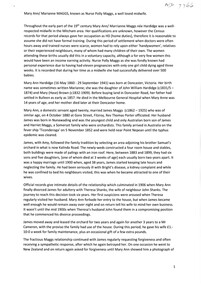
Instruction Manual, Arnall & Jackson, The Manual of Local Government, 1892
This the instruction manual of the (Victorian) local government law, published in 1892.Historical and research significanceFaded blue book, hard cover. -
 Wangaratta High School
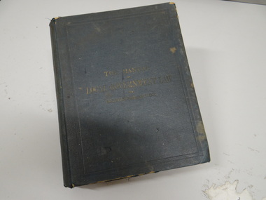
WHS Award Plaque, 2009
Black painted wooden trophy in the shape of Australia on a wooden stand. A science and engineering challenge logo in on the left and a silver metal plaque in on the right reading:nationally sponsored by The Australian Constructors Association The Science & Engineering Grand Challenge 2009 Finalist This initiative is supported by the Australian Government through the Department of Innovation, Industry, Science and Research -
 Wangaratta High School
WHS trophy, 2008
Glass geometric teardrop shaped trophy awarded to Wangaratta High School for placing runner up in the 2008 science and engineering challenge with silver text reading:The Science and Engineering Challenge Science and Engineering Challenge VICTORIAN SUPER CHALLENGE 2008 Presented by The University of Newcastle Latrobe University State Government Victoria in association with Engineers Australia WorleyParsons 2nd RUNNER UP this initiative is supported by the Australian Government through the Department of Innovation, industry, Science and Research -
 Wangaratta High School
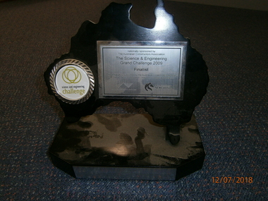
WHS trophy, 2008
Glass diamond trophy with a wooden base awarded to Wangaratta High School for winning the 2008 science and engineering Challenge with white text reading:The Science and Engineering Challenge Winning School- 11th April Wangaratta 2008 Presented by Victoria University faculty of Health, Engineering and Science This initiative is supported by the Australian Government through the Department of Innovation, industry, Science and Research -
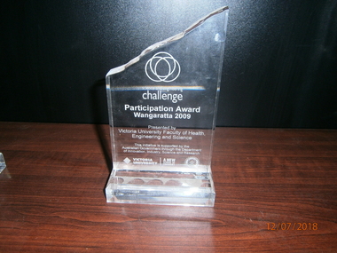 Wangaratta High School
WHS trophy, 2009
Glass trapezium shaped trophy with a rough cut top edge presented to Wangaratta High School for participating in the 2009 Science and Engineering Challenge and white writing reading:The Science and Engineering Challenge Participation Award Wangaratta 2009 Presented by Victoria university Faculty of Health, Engineering and Science This initiative is supported by the Australian Government through the Department of Innovation, industry, Science and Research -
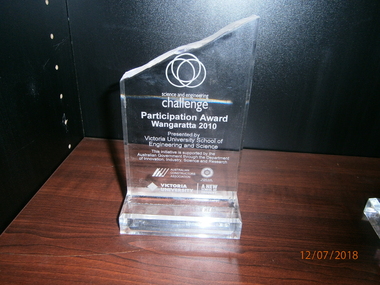 Wangaratta High School
WHS trophy, 2010
Glass trapezium shaped trophy with a rough cut top edge presented to Wangaratta high School for participating in the 2010 Science and Engineering challenge. Has white text reading:The Science and Engineering Challenge Participation Award Wangaratta 2010 Presented by Victoria university Faculty of Health, Engineering and Science This initiative is supported by the Australian Government through the Department of Innovation, industry, Science and Research -
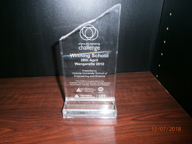 Wangaratta High School
WHS trophy, 2010
Glass trapezium shaped trophy with a rough cut top edge presented to Wangaratta high School for winning the 2010 Science and Engineering Challenge. Has white text reading:The Science and Engineering Challenge Winning School 28th April Wangaratta 2010 Presented by Victoria university School of Engineering and Science This initiative is supported by the Australian Government through the Department of Innovation, industry, Science and Research -
Southern Sherbrooke Historical Society Inc.
Information Folder - Germans Gully & Church of Freedom
Information folder containing items pertaining to the history of Germans Gully & Church of Freedom. Contents: -2 photos, gates of Church of Freedom -photocopy, sketch by Barbara Smith dated 29 October 02 of stone huts formerly on the property -article, "Fool around with scarlett!", Australian Post, 6 July 1972, re. John Wilson (colour copies in A3 folio #1 marked VSSH 71) -letter, Mother Superior Anne Beatrice, Church of Freedom LTD to Cr. M. Douglas, dated October 1983, requesting an audience with the council of the Shire of Sherbrooke. Attatched are biographical notes on John Wilson and his family -Memorandum of Association, Church of Freedom -Property report, 141 Mt Morton Rd, Belgrave Heights, from Victorian Government website -plan of survey, Crown Allotment 70, Parish of Narree Worran, showing Mt Morton Rd -Letter, dated 3 October 2005, from Gore Historical Museum & Hokonui Heritage Research Centre, Gore, New Zealand, to Mrs Eva Evans, Milton, New Zealand, re. John Charles Wilson, and covering the next three items -Funeral notice for John Wilson -Biographical entry for John Wilson from "Southern People - A Dictionary of Otago Southland Biography", 2 sheets -Biographical details from "Waitaki & Districts - A History", 1 sheetjohn wilson, church of freedom, germans gully, international bio colour naturopathic centre, wilson family -
Bendigo Historical Society Inc.
Document - Goornong Cemetery Headstones, August 1989
On 20th September 1878 land was gazetted for the purposes of a cemetery in the township of Goornong (Government Gazette, No. 53, 10th June 1881). The first burial occurred in the Goornong Cemetery on 4th August 1884. The site is known as Goornong Public Cemetery.Goornong Cemetery Headstones Research by Allan Llewellynhistory, bendigo, allan llewellyn collection, goornong cemetery -
 Bendigo Historical Society Inc.
Document - RESEARCH PAPERS: THOMAS WILKINSON PINNIGER, 1828
Thomas Pinniger (1828-1927) was born in England and emigrated to New Zealand before coming to Australia in 1852. With a team of 4 he conducted the first geodetic* survey of Victoria. He became the Government Surveyor for Bendigo in 1853 and in 1854 he laid out the plans for the town of Broadford. His son George, became the Victorian Surveyor General 1925-6. * Large scale mapping based on global measurements of large land masses. It allows corrections for the curvature of the earth.Document detailing the history of district serveyor Thomas Wilkinson Pinniger and his family history. -
Kew Historical Society Inc
Archive (Sub-series) - Subject File, Kew Historical Society et al, Human Services, 1997
Various partiesReference, Research, InformationSecondary Values (KHS Imposed Order)Subject file containing a three-part ‘Field Analysis’ / Major Assignment for RMIT Coursework by Lisa D’Acri and Simon Chambers on the History of Kew. Part 1 covers a ‘Community Area Profile’ (8 pages), Part 2 covers ‘Community Issues - The Effects of Amalgamation’ (4 pages), Part 3 covers ‘Human Service Organisation: Kew Residential Services’ (9 Pages). The research includes an analysis of demographic change over time, and summaries of interviews with residents and council officers. The file also includes the text of a talk provided by Lisa D’Acri to the Society in 1997 on Researching Kew’s History. Specific organisations covered include: Kew Cottages, St Nicholas Parents Assn. Inc.kew historical society - archives, kew - history, social services - kew (vic), local government amalgamations - kew (vic)kew historical society - archives, kew - history, social services - kew (vic), local government amalgamations - kew (vic) -
![Governing the Metropolis: politics, technology and social change in a Victorian city - Melbourne, 1850-1891 / [by] David Dunstan](/media/collectors/550653872162f11fb04854aa/items/5ed0413cdcf9cd08346b6448/item-media/5ed04231dcf9cd08346b66f5/item-fit-380x285.jpg) Kew Historical Society Inc
Kew Historical Society IncBook, Melbourne University Press, Governing the Metropolis: politics, technology and social change in a Victorian city - Melbourne, 1850-1891, 1984
Carlton, Vic. : Melbourne University Press, 1984 xvii, 362 p., [14] p. of plates : ill., facsims., maps, ports. ; 24 cm. non-fictionmelbourne metropolitan area (vic) -- politics and government -- 1851-1891., urbanization -- victoria -- melbourne. -
![Victoria's Colonial Governors 1839-1900 / [by] McCaughey, Perkins & Trumble](/media/collectors/550653872162f11fb04854aa/items/5ed05921dcf9cd08346c3084/item-media/5ed05a20dcf9cd08346c3c12/item-fit-380x285.jpg) Kew Historical Society Inc
Kew Historical Society IncBook, Victoria's Colonial Governors 1839-1900 / [by] McCaughey, Perkins & Trumble, 1993
The stories of the acheivements, friends and adversaries, changing roles and expectations, imagery and daily life of each of the Colonial Governors of Victoria starting with La Trobe in 1839 to 1854 and ending up with Lord Brassey who held the position from 1895 to 1900.xix, 453 p., 1 folded leaf, [8] p. of plates : ill. (some col.), ports. (some col.) ; 25 cm.non-fictionThe stories of the acheivements, friends and adversaries, changing roles and expectations, imagery and daily life of each of the Colonial Governors of Victoria starting with La Trobe in 1839 to 1854 and ending up with Lord Brassey who held the position from 1895 to 1900.governors -- victoria -- biography, victoria -- politics and government -- 1834-1900 -
![Colonial Consorts: The wives of Victoria's Governors 1839-1900 / [by] Marguerite Hancock](/media/collectors/550653872162f11fb04854aa/items/5ed05c0fdcf9cd08346c4ced/item-media/5ed05cbddcf9cd08346c5235/item-fit-380x285.jpg) Kew Historical Society Inc
Kew Historical Society IncBook, Colonial Consorts: The wives of Victoria's Governors 1839-1900 / [by] Marguerite Hancock, 2001
xxii, 324 p., [10] p. of plates : ill. (some col.), ports., photos. ; 25 cm.non-fictiongovernors' spouses -- victoria -- history -- 19th century., victoria -- politics and government -- 1834-1900. -
Kew Historical Society Inc
Book, Allen & Unwin, At The End Of The Road : Government, society and the disposal of human remains in the nineteenth and twentieth centuries, 1994
xvi, 464 p., [4] leaves of plates : ill. (some col.), plans, ports. ; 24 cm. non-fictioncemeteries -- south australia -- history, funeral rites and ceremonies -- south australia -- history, burial laws -- south australia, cremation -- south australia -- history -
Kew Historical Society Inc
Book, Pauline Jones, Beginnings Of Permanent Government, 1981
xv, 570 p. : ill., ports. ; 27 cm. non-fictionvictoria ca 1851-ca 1901, victoria - history - 1834-1900, victoria - politics and government - 1834-1900. -
Kew Historical Society Inc
Book, City of Boroondara, City of Boroondara Annual Report 2003-2004, 2004
non-fictioncity of boroondara (vic.), local government -- victoria -- annual reports -
![Borough of Kew - Gazetted Streets [1865-1937]](/media/collectors/550653872162f11fb04854aa/items/59614050d0cdd511a09c84a0/item-media/59614577d0cdd511a09e80c0/item-fit-380x285.jpg) Kew Historical Society Inc
Kew Historical Society IncDocument, Borough of Kew / Gazetted Streets, 1865-1937
The Melbourne suburb of Kew gained independence from the Boroondara Roads Board in 1860, being declared a Municipality in that year. Kew became a Borough in 1863, a Town in 1910, and a City in 1921. The former City of Kew became part of a newly declared City of Boroondara in 1994. This very fragile document records the following information about streets in Kew - Name, Total Width, Width of Carriageway, Description, Government Gazetted - Year & Page.While the name of a street was formally acknowledged and published in the Victorian Government Gazettes, this document, compiled by a public officer, probably in the Town Clerk's Department, is the earliest known local record listing street names in the Borough, later Town, then City of Kew. The front page indicates that in 1865, the responsibility for an initial 36 streets in Kew was taken over by Council. The final annotation in the document was made in 1937. The document is an important record for researchers seeking to understand the dating of streets in the district.27-page document compiled by officers of the Borough, Town and City of Kew, listing the names of streets taken over by Council, and providing details of their proportions and gazettiing. The document covers the period of 1865 to 1937. Handwritten documentborough of kew, streets -- kew (vic.) -
 Kew Historical Society Inc
Plan - Subdivision Plan, J Hurrey, Section 115 in the Parish of Boroondara Near Richmond Bridge, 1853
Despite the plans claims that it is a subdivision near the Richmond Bridge, Section 115 was located at what is now Camberwell Junction. While the plan only lists government roads rather than named streets, the section was located on the east side of Burke Road, stretching up the hill from the current Junction. Research on Trove, conducted by Kerry Fairbank, discovered an advertisement for unsold lots in Section 115 which clarifies the extent and location of subsequent land sales in the original section. The original article can be viewed through the link in the catalogue record. The interesting link to Kew is the reference to James Beavan as the purchaser of lots 14 and 15. The historian Gwen McWilliam has notes that a Mr Beavan changed his name from Bevan. The Bevans were descendants of the Derricks family of Kew. This subdivision plan is the earliest original map or plan in the collection which shows parts of what is now the City of Boroondara, dating from circa 1853. It provides important information for researchers on subsequent subdivisions following the original land sales in [Camberwell] Boroondara. The site, on the east side of Burke Road is a highly-significant and historic site. This is believed to be the only extant copy of the subdivision in public collections.A small plan on parchment listing 28 lots, between one and two acres each, for sale in Section 115 in the Parish of Boroondara, dating from 1853 when the portion was subdivided.Obverse: Lot 16 "Joseph Duval", Lots 14 & 15 "James Beavan". Other annotations (measurements) are unreadable. Reverse: "KH-981 / Section 115 in the Parish of Boroondara / Near Richmond Bridge / 1640T. / J Duval / 14-15 J. Beavanparish of boroondara, subdivision plans - camberwell, section 115 - boroondara, subdivision plans -- camberwell (vic), riverscape road, burke road, camberwell junction -
 Kew Historical Society Inc
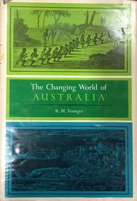
Book, Franklin Watts, The Changing World of Australia, 1963
General history with very brief mention of Aborigines.New York : Franklin Watts, 1963 vii, 253 p. ; 25 cm. non-fictionGeneral history with very brief mention of Aborigines.settlement and contacts - colonisation., settlement and contacts - ancient and early historical., politics and government - sovereignty, economic sectors - agriculture and horticulture - pastoral industry., settlement and contacts - government settlements, history - political. | settlement and contacts - settlers., australia -- history. -
 Kew Historical Society Inc
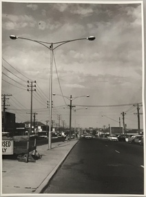
Photograph, Stuart Tompkins Studio, Electricity Supply Poles, Warrigal Road, Holmesglen, 1965
Research provided by Stuart Tompkins Studio, Box Hill, into alternatives for median strip street lighting to be used in Burke Road, Kew. The photographers identified variants in different suburbs appropriate to Kew's needs. The series from which the photograph is drawn provides a snapshot by a commercial photographic studio of each named vicinity in 1965 as well as providing examples of public works infrastructure being commissioned by local government in the 1960s. The photos originally formed part of the Engineering Department's files in the City of Kew before being donated to the kew Historical Society.Electricity Supply Poles, Warrigal Road, Holmesglen, 1965. Stuart Tompkins Studio provided this photograph for the Kew City Council. The photograph of Warrigal Road, north of Holmesglen looking north depicts wooden poles with bracket light fittings. These were the same as those proposed for Kew, except the lights and fittings were not to be 350 watt. Mercury lamps were preferred. [There are three copies of this photograph in the Collection.] Typed inscription on reverse: "Electricity Supply Poles. Photographed for Kew City Council 8/2/65. No.3 Warrigal Road - North of Holmesglen looking north. Wooden poles with bracket fittings same as those proposed for Kew except lights and fittings are not for 250 watt c. c. mercury lamps proposed. Wooden pole 3' up 11 3/4" dia." Studio stamp: "Stuart Tompkins Studio. 547 Station Street, Box Hill. WX1439."stuart tompkins studio, warrigal road (holmesglen) 1965, street lighting -
 Kew Historical Society Inc
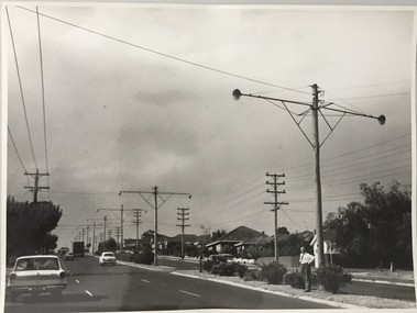
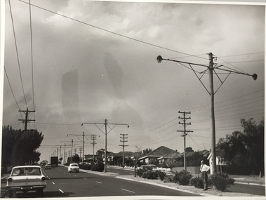
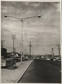
Photograph, Stuart Tompkins Studio, Electricity Supply Poles, South Road, Moorabbin, 1965
Research provided by Stuart Tompkins Studio, Box Hill, into alternatives for median strip street lighting to be used in Burke Road, Kew. The photographers identified variants in different suburbs appropriate to Kew's needs.The series from which the photograph is drawn provides a snapshot by a commercial photographic studio of each named vicinity in 1965 as well as providing examples of public works infrastructure being commissioned by local government in the 1960s. The photos originally formed part of the Engineering Department's files in the City of Kew before being donated to the kew Historical Society.Electricity Supply Poles, South Road, Moorabbin, 1965. Stuart Tompkins Studio provided this photograph for the Kew City Council. The photograph of South Road, Moorabbin, west of Jasper Road, looking east depicts steel poles with two lamps in a median strip and supply wires from pole to pole. The poles were described as 100′ apart. The notation on the rear of the photograph was that there were lamps along the median strip except at intersections. A wooden pole is recognised as supporting heavy supply lines across the road. The steel poles in the photograph were said to be between 3′ to 3.5′ whereas the wooden poles were three to 12.25″ in diameter. [There are three copies of this photograph in the Collection.] Typed inscription on reverse: "Electricity Supply Poles. Photographed for Kew City Council 8/2/65. No.2 South Road - Moorabbin, west of Jasper Road, looking east. Steel poles with two lamps in median strip and supply wires from pole to pole along median strip (poles only 100' apart). Lamps along median only except at intersections. Wooden pole supports heavy supply lines across the road. Wooden poles 3' up and 8 1/2" dia. Wooden poles 3' up and 12 1/2 dia." Studio stamp: "Stuart Tompkins Studio. 547 Station Street, Box Hill. WX1439."public infrastructure -- kew (vic.), city of kew - engineers department -
 Kew Historical Society Inc
Photograph, Stuart Tompkins Studio, Electricity Supply Poles, South Road, Moorabbin, 1965
Research provided by Stuart Tompkins Studio, Box Hill, into alternatives for median strip street lighting to be used in Burke Road, Kew. The photographers identified variants in different suburbs appropriate to Kew's needs.The series from which the photograph is drawn provides a snapshot by a commercial photographic studio of each named vicinity in 1965 as well as providing examples of public works infrastructure being commissioned by local government in the 1960s. The photos originally formed part of the Engineering Department's files in the City of Kew before being donated to the kew Historical Society.Electricity Supply Poles, South Road, Moorabbin, 1965. Stuart Tompkins Studio provided this photograph for the Kew City Council. The photograph of South Road, Moorabbin, west of Jasper Road, looking east depicts steel poles with two lamps in a median strip and supply wires from pole to pole. The poles were described as 100′ apart. The notation on the rear of the photograph was that there were lamps along the median strip except at intersections. A wooden pole is recognised as supporting heavy supply lines across the road. The steel poles in the photograph were said to be between 3′ to 3.5′ whereas the wooden poles were three to 12.25″ in diameter. [There are three copies of this photograph in the Collection.] Typed inscription on reverse: "Electricity Supply Poles. Photographed for Kew City Council 8/2/65. No.2 South Road - Moorabbin, west of Jasper Road, looking east. Steel poles with two lamps in median strip and supply wires from pole to pole along median strip (poles only 100' apart). Lamps along median only except at intersections. Wooden pole supports heavy supply lines across the road. Wooden poles 3' up and 8 1/2" dia. Wooden poles 3' up and 12 1/2 dia." Studio stamp: "Stuart Tompkins Studio. 547 Station Street, Box Hill. WX1439."city of kew -- engineers department, public infrastructure -- kew (vic.)