Showing 1019 items
matching houses and housing
-
 Eltham District Historical Society Inc
Photograph, Artichokes growing at Bell Street, Eltham, c.1990s
Fabbro's farm and house, Bell Street, Eltham, c.1990s. A crop of artichokes were planted on the farm at this time. The site of the Fabbro farm (Diamond Creek side land) is now called Barrack Bushlands. It is doubtful that Fabbro's farm holding was ever called Barrak Park, This title is fairly recent after the Shire of Eltham purchased the land, including the last section in 1993/94. About this time the area on the west side of Falkiner Street was purchased by a private developer and developed as housing. The area in Bell Street opposite the Eltham High School was purchased by the State Government is recent years and is called Fabbro Fields. The Fabbro Family operated their farm in Bell Street, Eltham. 1 colour photograph printed with white borderfabbro's farm, bell street, eltham, artichokes, barak farm -
 Eltham District Historical Society Inc
Photograph, Maurice Fabbro with artichokes growing at Bell Street, Eltham, c.1990s. Maurie is in his 70s
Fabbro's farm and house, Bell Street, Eltham, c.1990s. A crop of artichokes were planted on the farm at this time. The site of the Fabbro farm (Diamond Creek side land) is now called Barrack Bushlands. It is doubtful that Fabbro's farm holding was ever called Barrak Park, This title is fairly recent after the Shire of Eltham purchased the land, including the last section in 1993/94. About this time the area on the west side of Falkiner Street was purchased by a private developer and developed as housing. The area in Bell Street opposite the Eltham High School was purchased by the State Government is recent years and is called Fabbro Fields. The Fabbro Family operated their farm in Bell Street, Eltham. 1 colour photograph printed with white borderfabbro's farm, bell street, eltham, artichokes, barak farm, maurice fabbro -
 Tennis Australia
Lawn tennis set, Circa 1876
A chest (.1), housing a lawn tennis and badminton set. Black and green lithographic print features couples playing mixed doubles tennis and badminton in Cassiobury Park, with Cassiobury House in the background. Inscription: THE CASSIOBURY GAMES OF/BADMINTON AND GARDEN TENNIS/.../LONDON/DEAN & SON 160 FLEET STREET. The hourglass court used in Wingfield's version of lawn tennis is depicted in this lithograph. Contents include: racquets (.2 -.3); tennis balls (.4 - .5); shuttlecock (.6); badminton net (.7); guy ropes (.8 - .9); ornate pegs (.10 - .11); mallet (.12); and net posts (.13 - .14, 2 parts each). Materials: Wood, Metal, Ink, Glue, Paint, Paper, Lacquer, Gut, Rope, String, Velvet, Bird feather, Felt, Rubbertennis -
 Wodonga & District Historical Society Inc
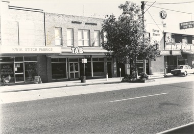
Photograph - Codling Collection 01 - Wodonga, High Street West - Kwik Stitch Fabrics, T.A.B. and Terminus Hotel, 1980s
Miss Olive Codling was a Foundation Member and a Life Member of the Wodonga Historical Society. Many of her prize-winning photos are held in the Society Collection. She also held a range of roles and committee positions in a wide range of Wodonga community organisations. These included the Horticultural Society, the Wodonga Arts Council, the Wodonga Camera Club and the Wodonga Lapidary Club. This photo collection is significant as it documents how the businesses and buildings in Wodonga have evolved and contributed to community throughout the 20th century.Wodonga, High Street West Businesses including Kwik Stitch Fabrics, T.A.B., Housing Advice and Referral Service, Nolans Sports Store, Pares House and the Terminus Hotel. The Terminus Hotel was built in 1873. It was purchased by Annie and George Allen in 1879. In 1888 they added extensions including a billiard room, a dining room and 18 other rooms. After the death of her husband, Annie Allen continued to run the Terminus Hotel. She later married John Haldon and was licensee of the hotel until 1893 when the license was transferred to William Carkeek. Carkeeks owned the hotel from 1900 - 1903 and again from 1906 - 1909. It was destroyed by fire in 1998 and the building demolished in 1999. In 2021 it is the location of Tristar Medical Centre. This T.A.B. store closed in 2006.wodonga businesses, high st wodonga, terminus hotel, nolans sports store -
 Glen Eira Historical Society
Book - Hillcrest Estate Draft Heritage Guidelines July 2000
2 items about Hillcrest Estate and heritage: 1/A 20 page report giving draft heritage guidelines by the City of Glen Eira for properties within the Hillcrest Estate Heritage Area of Caulfield South, including Hillcrest Avenue numbers 1 and 3-12 and Marara Road numbers 27 and 28. The Heritage Area has been assessed as noteworthy as 'the first housing estate developed by the AV Jennings Construction Co., later known as Jennings Group Limited.' Developed during the Depression years of the early 1930s, it is considered an 'unusually intact example of an interwar garden estate' and is also considered noteworthy for its aesthetic values. The Report describes typical features for two house forms typical of the area: the single-storey villa with decorative porch and the single storey villa with decorative verandah. It gives guidelines on the types of changes which can be made to houses within the Heritage Area. Included are photographs of typical houses and design features, maps, and diagrams showing acceptable zones for additions, amongst other Sections (eg. Key design checklist). 2/A three page photocopy taken from Andrew Ward's Heritage Study for The Hillcrest Estate Historic Area.hillcrest estate, glen eira heritage management plan, glen eira planning scheme, glen eira city council, hillcrest estate heritage area, hillcrest avenue, merri street, marara road, eumerella street, av jennings construction co, jennings group limited, caulfield south, jennings albert, brick houses, architectural styles, architectural features, housing estates, garden estate, heritage studies, glen eira city council, city of glen eira, draft heritage guidelines july 2000, glen huntly, vines william, gurney edward, eumeralla street, 'karkill', house names, cropmpton court, booran road, estate agents -
 Melton City Libraries
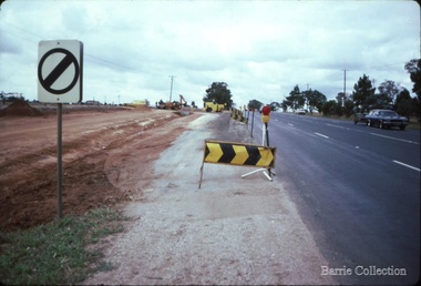
Photograph, Western Highway, 1983
Construction of service road in front of the former Ann Dowling (Miers) 1866 Crown Grant, Title dated October 1870. She married Henri Miers in 1867.Their house was located on the site near the Myers Gully part of Ryans Creek. Built in 1867 and later named “Burnbank” by Martha Myers after the Street in Ballarat were she lived before arriving in Melton in 1907. She married Frederick Myers in 1908. He died in 1963, and Martha moved to a new home at 5 McKenzie Street Melton in 1968. Attempts made by the family to retain the historic cottage were unsuccessful. A demolition order imposed by the Housing Commission and it was pulled down by the family. It was the home of the family and stood for over 100 years.East of Reserve Road towards Ferris Roadlandscapes of significance, misc. -
 Kiewa Valley Historical Society
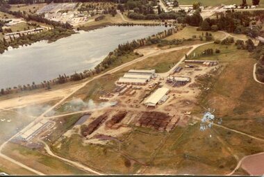
Photograph - Mt Beauty timber Industries, 1960's (estimate only)
Hume and Hovell discovered the area in 1824 and by the end of the 19th century the valley was transformed by logging, dairy and beef cattle properties and tobacco farms. Timber was required for construction of McKay Creek Power Station which began construction in 1951 and also the camps and houses for the workers and their families. There was a need for housing and infrastructure for an increasing population of workers for the hydro-electric scheme as there was a general shortage of this commodity. A timber mill was started in Tawonga by Mates, of Albury, in 1945, and electricity became available in 1946 the S.E.C. bought the mill, and enlarged it. In 1960 it was purchase by a local family. They also started a timber mill in Mt Beauty and worked both until 1980 when they closed the Tawonga mill and enlarged the mill called Mt. Beauty Timbers Pty Ltd which employed approximately 50 people. A pictorial record of the development of the Mt Beauty community and the local timber industry.Colour photograph of aerial view of Mt Beauty Timber Mills and surrounding area including pondage and part of airfield. Photo taken in 1960’s (estimate only)Handwritten in ink on back of photograph in very faint writing – Recent photo of Mt Beauty Timber Industries Mt Beauty Operationsmt beauty timber industry, timber industry, timber mill, secv -
 Kiewa Valley Historical Society
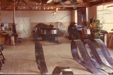
Photograph - Mount Beauty Timber Industries, 1960's (estimate only)
Hume and Hovell discovered the area in 1824 and by the end of the 19th century the valley was transformed by logging, dairy and beef cattle properties and tobacco farms. Timber was required for construction of McKay Creek Power Station which began construction in 1951 and also the camps and houses for the workers and their families. There was a need for housing and infrastructure for an increasing population of workers for the hydro-electric scheme as there was a general shortage of this commodity. A timber mill was started in Tawonga by Mates, of Albury, in 1945, and electricity became available in 1946 the S.E.C. bought the mill, and enlarged it. In 1960 it was purchase by a local family. They also started a timber mill in Mt Beauty and worked both until 1980 when they closed the Tawonga mill and enlarged the mill called Mt. Beauty Timbers Pty Ltd which employed approximately 50 people. A pictorial record of the development of the local timber industry in the Kiewa Valley showing equipment used in timber milling.Colour photograph of Mt Beauty Timber Industries Mill. Photo taken inside the workshop showing saw blades and equipmentmt beauty, mt beauty timber industry, timber mill -
 Warrnambool and District Historical Society Inc.
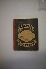
Tradesman’s Work Diary, Book, 1940s
This exercise book contains details on the work carried out by A.Greed, a tradesman undertaking small carpentry and repair jobs in the Warrnambool region. The works completed date from 17 April 1945 to 11 October 1949. Mr Greed apparently worked mostly for the Public Works Department and had contracts for schools including Ecklin South, Panmure, Cudgee, Dennington, Mailors Flat, Grasmere, and Warrnambool Technical School and for other public buildings including the Warrnambool Court House, the Police Station and Housing Commission buildings. Other contracts included ones for the Framlingham Aboriginal Reserve, Callaghan’s Garage, the Caledonian Hotel, the Methodist Croquet Club and many private home owners. Details on the identity of ‘A. Greed’ are not known as there are several possibilities for the 1940s era. One clue is that an ‘E. Greed’ was also an employee.This exercise book is of some interest as an example of a tradesman’s handwritten details of his work as a carpenter and repair man in the 1940s in the Warrnambool area. There are many local names and businesses of interest mentioned in the exercise book. This is an exercise book with a grey cover with red binding. The dark blue printing on the front cover is enclosed in scroll patterns and the back cover has dark blue printing The cover is creased and has some ink splotches. The front cover has been stamped but the printing is now mostly illegible. The pages contain handwritten work and accounting information in black and blue ink. Some pages have been overwritten in red and black ink and pencil and there is one loose sheet.The Vana Exercise Booka.greed,, warrnambool tradesman, history of warrnambool -
 Kew Historical Society Inc
Plan, Melbourne & Metropolitan Board of Works : Borough of Kew : Detail Plan No.1571, 1904
The Melbourne and Metropolitan Board of Works (MMBW) plans were produced from the 1890s to the 1950s. They were crucial to the design and development of Melbourne's sewerage and drainage system. The plans, at a scale of 40 feet to 1 inch (1:480), provide a detailed historical record of Melbourne streetscapes and environmental features. Each plan covers one or two street blocks (roughly six streets), showing details of buildings, including garden layouts and ownership boundaries, and features such as laneways, drains, bridges, parks, municipal boundaries and other prominent landmarks as they existed at the time each plan was produced. (Source: State Library of Victoria)This plan forms part of a large group of MMBW plans and maps that was donated to the Society by the Mr Poulter, City Engineer of the City of Kew in 1989. Within this collection, thirty-five hand-coloured plans, backed with linen, are of statewide significance as they include annotations that provide details of construction materials used in buildings in the first decade of the 20th century as well as additional information about land ownership and usage. The copies in the Public Record Office Victoria and the State Library of Victoria are monochrome versions which do not denote building materials so that the maps in this collection are invaluable and unique tools for researchers and heritage consultants. A number of the plans are not held in the collection of the State Library of Victoria so they have the additional attribute of rarity.Original survey plan, issued by the MMBW to a contractor with responsibility for constructing sewers in the area identified on the plan within the Borough of Kew. The plan was at some stage hand-coloured, possibly by the contractor, but more likely by officers working in the Engineering Department of the Borough and later Town, then City of Kew. The hand-coloured sections of buildings on the plan were used to denote masonry or brick constructions (pink), weatherboard constructions (yellow), and public buildings (grey). This plan is the other half of Plan No.1571 representing the constructions to the west of Wellington Street before and in 1903/4. This plan represents the built environment in Edgevale Road, Wellington Street, Atkins Street, Annadale Street, Mortimer Street, and Cotham Road. Whereas there are smaller allotments and more modest housing stock facing Edgevale Road, larger blocks and more substantial houses are represented facing Cotham Road.melbourne and metropolitan board of works, detail plans, mmbw 1571, cartography -
 Kew Historical Society Inc
Photograph - High Street, Kew, 1960-65
The borders of the main components of Kew and Kew East have not always conformed to current boundaries. In the past this photograph has been labelled as East Kew, whereas for most of the twentieth century the site has been within Kew's borders. The purpose of the photograph is unrecorded yet it has value in that it shows those businesses who occupied this site in Kew during the early 1960s.This small photograph is significant as it shows the location of and building used by WD Vaughan, former Mayor of Kew who was a successful newspaper proprietor in Melbourne.Small polaroid colour positive of High Street in Kew, probably in the 1960s. From left we can see the brick viaduct covering the tracks of what was once the Outer Circle Railway. Behind this brick wall, Dunnings Timber Yard was situated. At the end of the walls of the viaduct there is an entrance to a walkway [now the Anniversary Trail], which once provided access to Windsor Avenue, and also to the East Kew Station (now demolished and part of the Outer Circle Railway Reserve). On the other side of this walkway is a cream brick building (demolished) occupied at this time by WD Vaughan Pty Ltd, printer and publisher of the Kew Advertiser (newspaper). Stretching behind the brick facade is an extensive building that must have housed the printing works. Beside Vaughan's, there is a large building (demolished) housing at that time an estate agent named AJ Kennedy. This area is now separated by kerbing.High St East Kew / Corner of Harp Rd. / Looking South -
 Kiewa Valley Historical Society
Set of 2 hand coloured photographs of early Mount Beauty, photographs of Mount Beauty, 1947/48
Construction of the town of Mount Beauty commenced in 1946 and continued until 1952. It was built to provide family accommodation for workers engaged in the construction of the hydro electric power scheme. As well as housing, there was an administration building, staff hostel, merchandising centre, workmen's camps, base stores and workshops and the Mount Beauty Terminal Station. The first house was occupied in November, 1946 by the then manager of the trading store, with a frontage onto Hollonds Street. The total number of houses erected was 488, 162 custom built and 326 prefabricated. The main workmen's camp can be seen just left of the centre of the photograph and accommodated 144 men at the time of the photograph. By 1950 it could accommodate 1200men. Photo No. 1 is taken in 1947/early 1948 as there is no evidence of the staff hostel under construction. This hostel was commenced in August/September 1948 and is clearly shown in photograph No. 2, dating this photo as 1948 as it is before the completion of the bypass road connecting to the main (high plains) road. This road was constructed in 1939 and in 1948 followed the route of Tawonga Crescent. This remained in use until the bypass construction was completed in early 1949 and does not appear to be finished in this photograph.. Both photographs are taken from the power line easement adjacent to the Bright road.Significant historical pictorial record of the development of a town from grazing land. The type of terrain that had to be surveyed and then to construct roads and other infrastructure, with very little machinery, is also of prime significance in the development of the Kiewa Hydro Electric Scheme.Two photographs, both hand painted to show colours, and both of Mount Beauty c 1947/48 not long after commencement of construction of homes and facilities for workers.Photo No.1 - on back of photo, left upper corner, faintly in pencil, SPIKE, underneath this is written T Pay,. Photo No. 2 - on back of photo, left upper corner, faintly in pencil, Jmount beauty, housing, accommodation -
 Eltham District Historical Society Inc
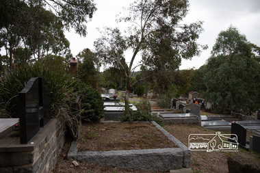
Photograph, Peter Pidgeon, Memorial to Alistair Knox, Eltham Cemetery, Victoria, 5 April 2021
Alistair Knox was an architect and builder who came to Eltham in 1948. Influenced by Frank Lloyd Wright and Walter Burley Griffin, he sought to create buildings that would blend into the landscape, enhanced by the planting of indigenous flora. The post-war shortage of building materials made traditional construction expensive. Adobe (mudbrick) provided a cheap and plentiful alternative, and one which would be aesthetically pleasing. Mud-brick manufacture was a problem at first. Sonia Skipper had been experimenting with Eltham clays for years to find the best mix for making bricks and render. Alistair employed her as building foreman on several of his sites. By the 1980s, he had brought mud-brick and earth building into the Australian mainstream, and a Knox-designed house had become highly desirable. Sonia said that he would craft a bespoke earthen house to fit with his client's lifestyle. He was drawn to the environmental movement, publishing three books on housing and the environment, and speaking on radio. He also served on the Eltham Shire Council 1971-1975, was Shire President 1974 and was instrumental in re-establishing the Eltham Community Festival in 1975. Alistair died in 1986 and is buried in a small garden setting at Eltham Cemetery.Born Digitaleltham cemetery, gravestones, heritage excursion, alistair knox -
 Eltham District Historical Society Inc
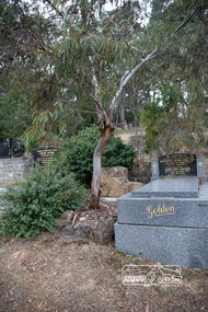
Photograph, Peter Pidgeon, Grave of Alistair Samuel Knox, Eltham Cemetery, Victoria, 5 April 2021
Alistair Knox was an architect and builder who came to Eltham in 1948. Influenced by Frank Lloyd Wright and Walter Burley Griffin, he sought to create buildings that would blend into the landscape, enhanced by the planting of indigenous flora. The post-war shortage of building materials made traditional construction expensive. Adobe (mudbrick) provided a cheap and plentiful alternative, and one which would be aesthetically pleasing. Mud-brick manufacture was a problem at first. Sonia Skipper had been experimenting with Eltham clays for years to find the best mix for making bricks and render. Alistair employed her as building foreman on several of his sites. By the 1980s, he had brought mud-brick and earth building into the Australian mainstream, and a Knox-designed house had become highly desirable. Sonia said that he would craft a bespoke earthen house to fit with his client's lifestyle. He was drawn to the environmental movement, publishing three books on housing and the environment, and speaking on radio. He also served on the Eltham Shire Council 1971-1975, was Shire President 1974 and was instrumental in re-establishing the Eltham Community Festival in 1975. Alistair died in 1986 and is buried in a small garden setting at Eltham Cemetery.Born Digitaleltham cemetery, gravestones, heritage excursion, alistair samuel knox -
 RMIT Design Archives
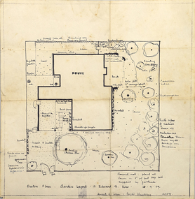
Diazotypes, Sketch Plan: Garden Layout - 13 Edward St. Kew
John and Phyllis Murphy designed this house and garden in Kew for Sir Frank and Lady Macfarlane Burnet in 1959, the year before Burnet and Peter Medaware received the Nobel Prize for discovering acquired immunological tolerance. For the most highly honoured scientist to have worked in Australia, Burnet's house is modest - single storey with two bedrooms. Typical of post-war suburban housing thought, the garden is a generous, and the planting a mix of existing shrubs and trees, old favourites such as camelias, hydrangeas, lilacs, and a unusually 'a thick copse of native trees'. John Murphy (1920-2004) and Phyllis Murphy (nee Slater) (1924-) are alumni of RMIT. John commenced his architectural studies at Swinburne Technical College prior to WW2, and subsequently studied at Melbourne Technical College (now RMIT University) from 1944 to 1946. Phyllis studied architecture at Melbourne Technical College from 1942, before transferring to Melbourne University's Architectural Atelier in 1944 They both completed their Bachelor of Architecture in 1949, with Phyllis topping the fourth year, and John coming in second. They established their architectural practice in 1950. One early project was their design with Kevin Borland and Peter McIntyre for the Olympic Swimming Pool (1956). Ann Carew 2018dye, paper, garden design, kew -
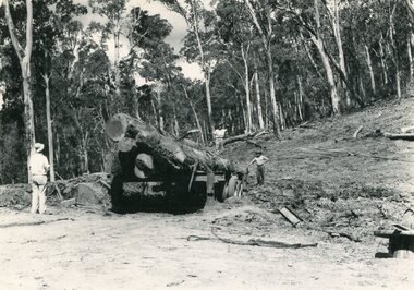 Kiewa Valley Historical Society
Photo - Mountain Creek Logging Camp, 1955
Hume and Hovell discovered the area in 1824 and by the end of the 19th century the valley was transformed by logging, dairy and beef cattle properties and tobacco farms. The logs could have been milled for timber at the State Electricity Commission's mill at Howman's Gap which provided a much needed source of timber for construction of McKay Creek Power Station which began construction in 1951 and also the camps and houses for the workers and their families. There was a need for housing and infrastructure for an increasing population of workers for the hydro-electric scheme as there was a general shortage of this commodity. A timber mill was started in Tawonga by Mates, of Albury, in 1945, and electricity became available in 1946 the S.E.C. bought the mill, and enlarged it. In 1960 it was purchase by a local family, they also started a timber mill in Mt Beauty worked both until 1980 when they closed it. The Tawonga mill and enlarged the mill called Mt. Beauty Timbers Pty Ltd employed approximately 50 people. An historical pictorial record of the general working conditions, type of machinery and vehicles in use in the 1950’s. Note the lack of protective clothing!Black and white photograph of the logging camp at Mountain Creek. November 1955Handwritten on the back of photograph - MOUNTAIN CREEK LOGGING CAMP NOV 55mountain creek logging camp, timber industry, tawonga -
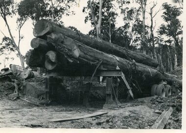 Kiewa Valley Historical Society
Photo - Logging. Mountain Creek, November 1955, November 1955
Hume and Hovell discovered the area in 1824 and by the end of the 19th century the valley was transformed by logging, dairy and beef cattle properties and tobacco farms. The logs could have been milled for timber at the State Electricity Commission's mill at Howman's Gap which provided a much needed source of timber for construction of McKay Creek Power Station which began construction in 1951 and also the camps and houses for the workers and their families. There was a need for housing and infrastructure for an increasing population of workers for the hydro-electric scheme as there was a general shortage of this commodity. A timber mill was started in Tawonga by Mates, of Albury, in 1945, and electricity became available in 1946 the S.E.C. bought the mill, and enlarged it. In 1960 it was purchase by a local family, they also started a timber mill in Mt Beauty worked both until 1980 when they closed it. The Tawonga mill and enlarged the mill called Mt. Beauty Timbers Pty Ltd employed approximately 50 people An historical pictorial record of the general working conditions, type of machinery and vehicles in use in the 1950’s. Black and white photograph of logging at Mountain Creek November 1955Small typed note attached to the back of photo - Logging Mountain Creek November 1955mountain creek logging camp, tawonga, timber industry -
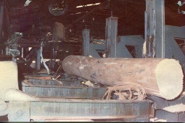 Kiewa Valley Historical Society
Photographs - 2 Colour photographs of logs being harvested and milled for timber in the Kiewa Valley
: Hume and Hovell discovered the area in 1824 and by the end of the 19th century the Kiewa Valley was transformed by logging, dairy and beef cattle properties and tobacco farms. The logs could have been milled for timber at the State Electricity Commission's mill at Howman's Gap which provided a much needed source of timber for construction of McKay Creek Power Station which began construction in 1951 and also the camps and houses for the workers and their families There was a need for housing and infrastructure for an increasing population of workers for the hydro-electric scheme as there was a general shortage of this commodity. A timber mill was started in Tawonga by Mates, of Albury, in 1945, and electricity became available in 1946 the S.E.C. bought the mill, and enlarged it. In 1960 it was purchase by a local family, they also started a timber mill in Mt Beauty worked both until 1980 when they closed the Tawonga mill and enlarged the mill called Mt. Beauty Timbers Pty Ltd which employed approximately 50 people. An historical pictorial record of the type of machinery and vehicles in use in the 1950’s to harvest and mill the logs from surrounding forested areas.1. Colour photograph of large logs being milled for timber at a timber mill 2. Colour photograph of heavy machinery being used to harvest large logs for milling timber; timber mill; kiewa valley; forests; logging -
 Melton City Libraries
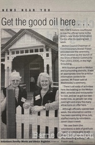
Newspaper, Get the good oil here…, 2001
"A court was established in Melton by 1864, when the first recorded case was heard before Mr BA Porter JP, with Mr A Carroll as the Clerk of Courts. John James was convicted of being drunk, for which he was fined five shillings or 24 hours imprisonment. The court was held in the ‘long room’ of the old Melton Hotel, before moving to rented accommodation at the Raglan Hotel, and finally to the Roads Board office. Tenders for construction of the present building were called for by the Public Works Department on 13th February 1892. The architect Samuel Edward Brindley was born in Birmingham, England, in 1842. He was articled to the local architect, J.R. Botham, FRIBA, before emigrating to Victoria where he was employed as an architect in the Education Department from 18 August 1873. With the amalgamation of the architectural branch of the Education Department with the Public Works Department in 1884, Bindley was placed in charge of Victorian government building design for the North-Western District. In 1975, the Melton and District Historical Society became concerned at hearsay that the court house was to be demolished to make way for carparking space. Melton had been declared a ‘satellite city’ and was developing rapidly. A new shopping centre had recently been built at a setback of 60 feet (c.18 metre) from 323-329 High Street, and the court house, together with the adjacent weatherboard police station, had been left standing alone. A new police station was planned, and the weatherboard police station was subsequently demolished. In its nomination of the building for National Trust classification the Society argued that the Court House was ‘the best of two early buildings left in the main street’ (the other being a bluestone hotel) and that its loss would be ‘tragic’. However the nomination was unsuccessful, the National Trust at the time judging that it was of no particular ‘distinction’ or ‘antiquity’. The building continued to be used as a court house at least until 1991 when the Department of Housing and Construction (formerly the PWD) conducted a heritage study of court houses. By this time Federation-era architecture had achieved acceptance within the heritage movement. The building was recognised as being ‘the only surviving example in brick of the Federation Queen Anne style which was used for court houses only twice.’ Twenty years later when it was proposed to modify the eastern façade of the building to accommodate a café, the M&DHS was again concerned. This time the National Trust objected that the proposed extension would be an over-development of the site, and questioned the changes to the interior court room furnishings and fittings. The site never appears to have been nominated to the Victorian Heritage Register. It has since been converted into the Shire of Melton Tourist Information Centre". Opening of the Visitor Centre in Meltoncouncil, local architecture -
 Bendigo Historical Society Inc.
Book - JOAN O'SHEA COLLECTION: 150TH ANNIVERSARY OF BENDIGO BOOKLET, 1850 - 1950's
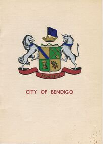
Joan O'Shea Collection. Buff Coloured Booklet City of Bendigo. 150th anniversary of Bendigo 1850s to 1950s. Image on cover coat of arms for City of Bendigo underneath word progress, left hand side horse, right hand side bullock. History of Bendigo: From Sheep Run to Provincial City in 100 years. Map of Bendigo and Surrounds Railways, Water Courses & Storage, Power, Municipal Boundaries & Land Available for Industry. Municipal District Creation 1855, Borough Proclamation 1863, Proclaimed City 1871, Area: 7992 Acres Population as of last census City of Bendigo 28,722, City of Bendigo and adjacent Urban Areas 36,909. City of Bendigo Map, The Past Prior to 1850. Icons of Bendigo The Bendigo base Hospital,Law Courts & Post Office, Primary Schools, Housing, Industry including Butter Production, Poultry Farming, Livestock Sales & Tomato Growing, Slaughter House & ordnance factory. The Present Recreation Photos: Bendigo Bowling Club, Queen Elizabeth Oval, Municipal Lawn Tennis Courts The Future of Bendigo, Bendigo Photographs From The 1950s,Cambridge Press Bendigobendigo, history, progress of bendigo 1850s on. -
 The Beechworth Burke Museum
Audio - Oral History, Jennifer Williams, Sister Elizabeth McGovern, Sister Mary Lacey, Sister Mary Griffiths, Sister Gerardus Thistlewaite, 18th March 2000
Sister Elizabeth McGovern, Sister Mary Lacey, Sister Mary Griffiths, and Sister Gerardus Thistlewaite were all nuns of the Brigidine Order in Beechworth in the second half of the twentieth century. They had backgrounds in teaching and office work. As nuns, their contributions to the community included teaching, running camps, being there for community members wishing to talk to them or pray, and visiting prisons and hospitals. During their time in the order, the role of the nuns in Beechworth shifted due to the closing down of the Priory School, and changes in where housing for nuns was provided. The oral history also includes stories of boarding at the convent in the 1950s, and reflections on how the experience of being a nun has changed due to increasing immersion in the modern world, and the move from convent to house. This oral history recording was part of a project conducted by Jennifer Williams in the year 2000 to capture the everyday life and struggles in Beechworth during the twentieth century. This project involved recording seventy oral histories on cassette tapes of local Beechworth residents which were then published in a book titled: Listen to what they say: voices of twentieth century Beechworth. These cassette tapes were digitised in July 2021 with funds made available by the Friends of the Burke.Sister Elizabeth McGovern, Sister Mary Lacey, Sister Mary Griffiths, and Sister Gerardus Thistlewaite's interview with Jennifer Williams is revealing of the history of the Brigidine order in Beechworth, and the role religion and nuns played in the wellbeing, education, and life of the community in the latter half of the twentieth century. It is significant both for what it illustrates about the lives and motivation of the Sisters, and for what it tells us about how the role of religious education and figures shifted in Beecjhworth from 1950 onward. It is especially illuminating about the experience of women in education. This oral history account is socially and historically significant as it is a part of a broader collection of interviews conducted by Jennifer Williams which were published in the book 'Listen to what they say: voices of twentieth-century Beechworth.' While the township of Beechworth is known for its history as a gold rush town, these accounts provide a unique insight into the day-to-day life of the town's residents during the 20th century, many of which will have now been lost if they had not been preserved.This is a series of digital recordings that were originally recorded on multiple cassette tapes. The cassette tapes are black with a horizontal white strip and are currently stored in a clear flat plastic rectangular container. They up to 40 minutes of recordings on each side.Sister Elizabeth McGovern, Sister Mary Lacey, Sister Mary Griffiths, Sister Gerardus Thistlewaitelisten to what they say, listen to what they say: voices of twentieth century beechworth, nuns, brigidine sisters, brigidine convent, school, religion, prison, boarding school, modernization, food, women's history, teaching, teachers, education, hospitals, beechworth hospital, charity, old priory, father stockdale, easter, beechworth 1950s -
![Map, Millbank Estate Bacchus Marsh Thursday 4th October 1888 [Land sales], 1924](/media/collectors/5e461d8021ea67224c82f2a1/items/67765662eb6d2cbd24e0797f/item-media/67765682eb6d2cbd24e07a41/item-fit-380x285.jpg) Bacchus Marsh & District Historical Society
Bacchus Marsh & District Historical SocietyMap, Millbank Estate Bacchus Marsh Thursday 4th October 1888 [Land sales], 1924
The Millbank Estate was a parcel of land close to the centre of the shopping area of Bacchus Marsh which was sub-divided and offered for sale in 62? lots on the 4th October 1888. The lots had frontages to Ballarat Road (Main Street), Maddingley Road (now Grant Street), Turner Street, Millbank Street, Clarinda Road (now Clarinda Street), and an unnamed street south of Turner Street (possibly known as Grant Street at this time) which connected to Maddingley Road through the vicinity of the present day Bacchus Marsh Hospital. This was a significant sub-division of land and represented a major expansion of residential housing in Bacchus Marsh in the late 19th century. The map includes a wealth of detail about the time of the sale, where it will take place, who the selling agents were, the deposit terms for purchases and details of a special train from Melbourne to Bacchus Marsh on sale day. The location of the allotments in relation to the shopping and commercial area of Bacchus Marsh, Maddingley and the railway station are indicated on an inset map within the overall map and poster. The Millbank Estate area was an area which had once belonged to the Grant family who were prominent early citizens of Bacchus Marsh and lived in a house in this area known as 'Millbank'.This land sale map is a typical example of housing estate land sales advertising maps produced by real estate agents in this era. The map is significant for the detailed information it provides about when and where land was sold for new housing estates in Bacchus Marsh in the late nineteenth century.Single page map showing land allotments for sale at auction in Bacchus Marsh in October 1888. A significant portion of the map is missing from the bottom right side. land sales bacchus marsh, land subdivsion bacchus marsh, housing estates land sales bacchus marsh, grant family bacchus marsh, millbank estate land sales -
 Robin Boyd Foundation
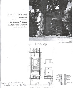
Article, Japan Interior Design, An Architect's House in Melbourne, Australia. Architect: Robin Boyd, Feb-62
This Japanese journal features a photographic article on Boyd's Walsh Street home. It was written by a Japanese architecture student who visited Walsh Street with a group of 6 such students in 1961. A translation of the text follows. ________________________________________________________ "An Architect’s House in Melbourne, Australia Author: Tamon Okubo This house was built by architect Robin Boyd as an experimental work. Although in a residential area of Melbourne, the site is a 40 x 126 ft rectangle in a corner of a former park with high rise buildings on either side. Due to its location, the design focuses on protecting the privacy of the house from the outside and on the composition of the interior space, creating a somehow introverted plan. However, the interior is not completely closed from the outside; it is cleverly designed to provide both views of the rooves of nearby houses as well as the mountains in the distance. Firstly, the couple’s room and the children’s rooms are in separate buildings. These two independent structures are connected by a courtyard. The ceiling of the courtyard is partly open, so one can look out from the second-floor terrace of the couple’s room. The walls on both sides of the courtyard are of opaque glass to ensure privacy from outside. In both buildings brick walls with three-inch steel pipe inserted into the brick cavities form the structure and separate each room. The roof is connected to pairs of 3/4-inch thick cables, spaced four feet apart, attached to the brick walls of both buildings and supported by wooden posts that separate the glass panels in the rooms. The cables are not tightly strung together but are loosely suspended from the front structure, where the entrance is, to the rear one. The upper cable in the courtyard is covered with vine. The materials used are insulation board for the roof, raw timber for the structural materials, native jarrah for the timber sections of the interior walls and white eucalyptus for the joints. Robin Boyd – A Brief Personal History 1919 Born in Melbourne, Australia 1947 As an architect, was the first director of the Small Homes Service, a public housing research institute established to provide homes for needy Australians. 1960 Wins the American Institute Architects Prize (the Japanese architect, Kenzo Tange, was awarded the same prize in 1959). In the same year he was elected an honorary member of the Institute. Mr Robin Boyd is currently writing a book on the history of Australian architecture, The Walls Around Us, as well as a book on Kenzo Tange. He is a frequent visitor to Japan to exchange ideas with Japanese architects and is quite a Japanophile. " This is a photocopy of the article from Japan Interior Design No 17. Pages 4-5 are glued together, and pages 6-7 are glued together, p8 p9, p10 are separate. There is writing on it (not Robin Boyd's hand). Geoffrey Serle, Robin Boyd's biographer, may have given it to Patricia Boyd.walsh st library -
 Eltham District Historical Society Inc
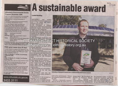
Document - Property Binder, 1184 Main Road, Eltham
Newspaper article: A sustainable award, Diamond Valley Leader, 1 November2006, Architect and building Llewellyn Pritchard won resource Efficiency Housing Award, finalist in HIA Greensmart Building of the Year Award. House – Environmental Leader (Published: Nillumbik Now and Then / Marguerite Marshall 2008; photographs Alan King with Marguerite Marshall.; p186) In 2006 environmental awareness was mushrooming in the community, which is reflected in the award-winning house at Main Road near Wattletree Road, Eltham. At first sight, the building appears a mix of a classic Eltham mud-brick house and an avant-garde building style. The crown of solar panels stretching along the width of the curved roof, indicates that this is no ordinary house. In fact it signals a new building trend of minimal impact on the environment. Yet it utilises the environment with high technical expertise to achieve comfort and cut running and maintenance costs. In recognition of this, its designer/builder, Conscious Homes, won the 2006 National HIA Greensmart Resource Efficiency Award. For Conscious Homes director, Llewellyn Pritchard, this house reflects a philosophy, strengthened by his connection with Aboriginal culture, through his foster siblings. Pritchard believes the sustainable way indigenous Australians lived and their spiritual connection with land, demonstrates how humanity is part of the ecology. His interest in environmental design stemmed from growing up in bushy Eltham Shire, with its mud-brick tradition. This was followed by studying Architecture at RMIT in the early 1980s, and learning about passive solar design. Pritchard says this house demonstrates that environmental sustainability is not about sacrifice, but about exceptional levels of occupant comfort, savings in running costs and modern fittings and appliances.1 The solar panels on the north roofs are intentionally obvious to make a statement about what the building is doing. But inside the systems are hidden and interactive with conventional services, such as the underground water tank. The house is water and energy self-sufficient and at 12 squares is much smaller than conventional houses, to minimise resources. Yet it accommodates his family of four with three bedrooms, a living/dining and kitchen area and a bathroom/laundry. Importantly the building is designed to last hundreds of years, by being able to be modified as the need arises, such as for commercial use. In this way the structure minimises its environmental impact. The solid double mud-brick walls (which are insulated) include steel beams and supporting frame, allowing the future removal or alteration of any section. The materials are local, recycled and of low toxicity where possible.2 Inside and out, the mud-brick is rendered and sealed with a combination of cement and sand and a mud-based coating in a soft golden hue increases its life. Inside, the golden-brown timber is plantation Mountain Ash and the concrete floors throughout – of local stone aggregate with a clear seal – have a natural looking random stone appearance. The house sustains a stable temperature of around 20 degrees, assisted by the concrete slab floor. The many large double-glazed windows and highlights (windows set high on walls) provide cross-flow ventilation. The north-facing living area maximises heating from the lower winter sun and is cooler in summer, because the sun is higher. Heating comes from a solar hydronic slab system. All appliances and fittings are high efficiency energy or water rated. Appliances in the timber kitchen include a gas stove and a dishwasher, using the building’s own power and water. French doors open from the living area to a deck, concealing the treatment system for all waste water. This is pumped through sub-soil drippers to the indigenous garden beds and no-dig vegetable patch. Below the carport is the 80,000-litre rainwater tank and at the back, the boiler room houses the solar boiler, water tank access, domestic water supply pump, filter gear and hydronic slab heating controls. The solar system is backed up with gas, which is needed to heat water only in winter. Gas used is less than one quarter of that for an average home with ducted heating. Excess power is fed back to the grid and the building uses about one quarter of the mains electricity of an average home. Other local builders have followed Pritchard’s lead in resource efficiency for minimal environmental impact.main road, eltham, businesses, llewellyn pritchard, hia greensmart building of the year award., efficiency housing award, conscious homes australia pty ltd -
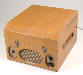 Vision Australia
Equipment - Object, Clarke & Smith, Clarke & Smith cartridge player, 1950-1960's
The first tape based talking book machine from the late 1950s, produced by Clarke & Smith, that allowed the listener to hear up to 20 hours of recordings. Although bulky (each tape cartridge alone weighed over 2 kgs), the MK1 was the first magnetic, multi-track tape produced and considered quite novel for it's time. The cartridge designed to be played on the Clarke & Smith MK1 Talking Book player came in it's own separate container. Each cartridge houses the complete mechanism, track change linkages, replay heads and tape spools, which are stacked on top of each other within the housing. When one track was finished, the user was required to lift the metal cassette, turn it over, and replace it on the turntable. The bulky cartridges were distributed by post or train in strong 'Globite' cases made with reinforced corners and strapped. The costs associated with talking book players were high and individuals/groups/service clubs were asked to sponsor a machine to help those who could not afford to buy or rent one. In this example, a plate attached to the lid indicates who raised the funds: "This talking book/is presented to you/by Tallimba Branch/ of CWA of NSW." Please note: despite images, there are no cartridges with this model.Metal talking book machine housed in a brown wooden carry case. There are two plastic knobs on the front facing right hand side, and an electric cord extending from the back of the case. To the left of the knobs is a speaker grille. Also includes talking book cartridge 'The darling buds of May'.audio equipment, clarke and smith -
 Department of Health and Human Services
Photograph, Berry Street Kindergarten
In 1877 the Victorian Infant Asylum was founded in Kew. In 1881, the asylum relocated to Berry Street in East Melbourne. By 1908, it was called the Foundling Hospital and Infants Home. It was non-denominational and controlled by a committee of management. By 1956, Berry Street consisted of a Mothercraft Training Centre and two main residential units: Berry Street for infants aged zero to 18 months, and Vale Street for toddlers aged zero to two years old. In August 1956, Berry Street was declared an approved category 2 Children's Home. In 1960, Vale Street was converted to an adult nursing home. In 1964, the name was changed to Berry Street Babies Home and Hospital. Berry Street was also an approved adoption agency. By 1968, Berry Street comprised the Training School for Mothercraft Nurses, the adoption agency, an infant life-protection house, a long-stay home for children to three years of age (the toddlers’ wing) and a small house for unmarried mothers. The home's infant life-protection work was seen as a critical agency function, particularly where family illness was putting pressure on mothers and Berry Street was able to provide respite and support. By the late 1960s, 30–40 adoptions annually were being arranged from Berry Street. By 1974 the home's orientation had shifted. Four family group homes had been established (two in Burwood, one in Ashburton and one in St Kilda), the mothercraft training function had been phased out, the toddlers wing converted to day care, and the main building (containing the nursery, administration, kitchen, dining room and single mothers accommodation) was demolished in favour of four home units, which housed 24 children, supervised by cottage parents. Berry Street provided short term, emergency and residential care for 'protection of infant' cases and state wards. Two flats were also established for short-term family accommodation. The nurses’ home was converted to house the home’s administration function and a social work service. The social work service coordinated family aid and family counselling services, and a neighbourhood house. In 1975 Berry Street also provided short-term care for 42 Vietnamese children brought to Australia in the official government-sponsored airlift. In 1976 Berry Street made application to change its category 2 Children's Home classification to category 1, as it was now catering for a wider range of children. It had ceased to be a babies’ home and hospital, and had started providing child and family care, including residential care. In 1977 Berry Street to established a family group home in Richmond to house children affected by the closure of St Cuthbert's Children's Home in Colac. Berry Street changed its name to Berry Street Child and Family Care in 1977. In 1978, the range of services provided by Berry Street Child and Family Care consisted of a social work counselling service, a financial aide, a family aide program using volunteers, two temporary accommodation units each housing eight children, an information and referral service, a neighbourhood house in Richmond, a day care centre for 36 children, and four family group homes. In 1980–81 the family group homes in Burwood were sold and the resources moved to the Richmond area. In 1994, Sutherland Youth and Family Services Inc. amalgamated into Berry Street Inc. During the 1990s, Berry Street combined with the Sutherland Community Resource Centre in Watsonia in Melbourne’s northern region. The agency operates today as Berry Street Victoria and has service centres across metropolitan and country Victoria. https://www.findingrecords.dhhs.vic.gov.au/CollectionResultsPage/BerryStreet -
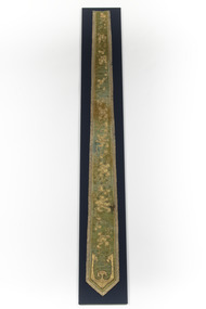
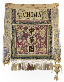 The Beechworth Burke Museum
Textile - Banner, c1872
This banner was one of five banners gifted to the Beechworth Chinese community in recognition of their support of the Hospital and Benevolent Asylum in 1875, from the Carnival Committee. These banners had been purchased in China by a social envoy from Beechworth then presented to the Chinese community during the Beechworth Fine Arts Exhibition in May of that same year, by Donald Fiddes, President of the Ovens District Hospital. The Burke Museum's Chinese Collection presents the history of Chinese settlement in Beechworth from 1856 and its involvement in local community affairs in the second half of the 19th century. In settling in the area they formed their own community with distinctive Chinese cultural traditions, forming their own 'camps' with laid out streets, housing a Temple, Chinese Theatre and restaurants, hotels, stores, gambling houses and dwellings. Members of the Chinese community took an active interest in town affairs and were generous donors to the appeal to build the Ovens District Hospital in 1856/7. The vibrant colours and dynamic graphics of the silk embroidered Chinese banners were a highlight of Beechworth Charitable processions that took place in the main street. Two of the Chinese banners were conserved for the Burke Museum in 2006 by Carol Campbell of Phoenix Conservation Services with funding from Victoria’s Heritage Grants. In 2015, with the enormous support of the Copland Foundation and fundraising activities by the Friends of the Bur Museum Committee, conservation of the third banner was undertaken by Artlab Australia in Adelaide. The banners display traditional Chinese textile techniques and are visually beautiful and very rare and are considered of local and national significance, with the potential to be deemed internationally significant.Multi panelled banner with embroidery and applied design motifs on front. Back panel is painted design of two men. The front panels have been constructed using strips of various weaves and colours of silk that have been embroidered or had a design applied prior to the overall construction of the piece. The embroidery is predominantly gold work with both plyed and floss silk threads. Silk macrame fringe and tassels to central panel and padded lotus and bowl motif hanging tassel from side panels. Velvet lettering applied to front "CHINA" CHINA /beechworth, burke museum, chinese, benevolent asylum, ovens district hospital, beechworth carnival processions, carnival, processions, beechworth chinese community, beechworth fine arts exhibition, donald fiddes -
 The Beechworth Burke Museum
Textile - Banner, c1872
This banner was one of five banners gifted to the Beechworth Chinese community in recognition of their support of the Hospital and Benevolent Asylum in 1875, from the Carnival Committee. These banners had been purchased in China by a social envoy from Beechworth then presented to the Chinese community during the Beechworth Fine Arts Exhibition in May of that same year, by Donald Fiddes, President of the Ovens District Hospital. The Burke Museum's Chinese Collection presents the history of Chinese settlement in Beechworth from 1856 and its involvement in local community affairs in the second half of the 19th century. In settling in the area they formed their own community with distinctive Chinese cultural traditions, forming their own 'camps' with laid out streets, housing a Temple, Chinese Theatre and restaurants, hotels, stores, gambling houses and dwellings. Members of the Chinese community took an active interest in town affairs and were generous donors to the appeal to build the Ovens District Hospital in 1856/7. The vibrant colours and dynamic graphics of the silk embroidered Chinese banners were a highlight of Beechworth Charitable processions that took place in the main street. Two of the Chinese banners were conserved for the Burke Museum in 2006 by Carol Campbell of Phoenix Conservation Services with funding from Victoria’s Heritage Grants. In 2015, with the enormous support of the Copland Foundation and fundraising activities by the Friends of the Bur Museum Committee, conservation of the third banner was undertaken by Artlab Australia in Adelaide.The banners display traditional Chinese textile techniques and are visually beautiful and very rare and are considered of local and national significance, with the potential to be deemed internationally significant.Multi panelled banner with embroidery and applied design motifs on front. The front panels have been constructed using strips of various weaves and colours of silk that have been embroidered or had a design applied prior to the overall construction of the piece. The embroidery is predominantly gold work with both plyed and floss silk threads.beechworth, burke museum, chinese, benevolent asylum, ovens district hospital, beechworth carnival processions, carnival, processions, beechworth chinese community, beechworth fine arts exhibition, donald fiddes -
 The Beechworth Burke Museum
Textile - Banner, c1872
This banner was one of five banners gifted to the Beechworth Chinese community in recognition of their support of the Hospital and Benevolent Asylum in 1875, from the Carnival Committee. These banners had been purchased in China by a social envoy from Beechworth then presented to the Chinese community during the Beechworth Fine Arts Exhibition in May of that same year, by Donald Fiddes, President of the Ovens District Hospital. The Burke Museum's Chinese Collection presents the history of Chinese settlement in Beechworth from 1856 and its involvement in local community affairs in the second half of the 19th century. In settling in the area they formed their own community with distinctive Chinese cultural traditions, forming their own 'camps' with laid out streets, housing a Temple, Chinese Theatre and restaurants, hotels, stores, gambling houses and dwellings. Members of the Chinese community took an active interest in town affairs and were generous donors to the appeal to build the Ovens District Hospital in 1856/7. The vibrant colours and dynamic graphics of the silk embroidered Chinese banners were a highlight of Beechworth Charitable processions that took place in the main street. Two of the Chinese banners were conserved for the Burke Museum in 2006 by Carol Campbell of Phoenix Conservation Services with funding from Victoria’s Heritage Grants. In 2015, with the enormous support of the Copland Foundation and fundraising activities by the Friends of the Bur Museum Committee, conservation of the third banner was undertaken by Artlab Australia in Adelaide. The banners display traditional Chinese textile techniques and are visually beautiful and very rare and are considered of local and national significance, with the potential to be deemed internationally significant.Multi panelled banner with embroidery and applied design motifs on front. The front panels have been constructed using strips of various weaves and colours of silk that have been embroidered or had a design applied prior to the overall construction of the piece. The embroidery is predominantly gold work with both plyed and floss silk threads.beechworth, burke museum, chinese, benevolent asylum, ovens district hospital, beechworth carnival processions, carnival, processions, beechworth chinese community, beechworth fine arts exhibition, donald fiddes -
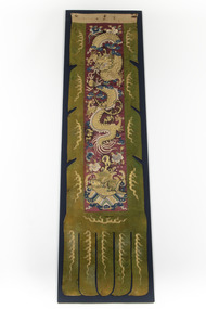
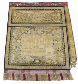 The Beechworth Burke Museum
Textile - Banner, c1872
This banner was one of five banners gifted to the Beechworth Chinese community in recognition of their support of the Hospital and Benevolent Asylum in 1875, from the Carnival Committee. These banners had been purchased in China by a social envoy from Beechworth then presented to the Chinese community during the Beechworth Fine Arts Exhibition in May of that same year, by Donald Fiddes, President of the Ovens District Hospital. The Burke Museum's Chinese Collection presents the history of Chinese settlement in Beechworth from 1856 and its involvement in local community affairs in the second half of the 19th century. In settling in the area they formed their own community with distinctive Chinese cultural traditions, forming their own 'camps' with laid out streets, housing a Temple, Chinese Theatre and restaurants, hotels, stores, gambling houses and dwellings. Members of the Chinese community took an active interest in town affairs and were generous donors to the appeal to build the Ovens District Hospital in 1856/7. The vibrant colours and dynamic graphics of the silk embroidered Chinese banners were a highlight of Beechworth Charitable processions that took place in the main street. Two of the Chinese banners were conserved for the Burke Museum in 2006 by Carol Campbell of Phoenix Conservation Services with funding from Victoria’s Heritage Grants. In 2015, with the enormous support of the Copland Foundation and fundraising activities by the Friends of the Bur Museum Committee, conservation of the third banner was undertaken by Artlab Australia in Adelaide.The banners display traditional Chinese textile techniques and are visually beautiful and very rare and are considered of local and national significance, with the potential to be deemed internationally significant.The banner has a narrow fuchsia embroidered top border, a wider embroidered panel depicting 2 dogs with embroidered Chinese text and a larger lower panel with the embroidered text “PRESENTED TO THE CHINESE OF BEECHWORTH BY THE COMMITEES OF THE PUBLIC INSTITUTIONS (missing) THAT TOWN IN COMMEMOR (missing) OF THE CARNIVAL 1873” The 2 lower panels have narrow decorative borders decorated with mirrors and extensive embroidery. There is an additional embroidered tab running along the right hand edge. The bottom edge has a wide knotted fringe. The back is lined with fabric decorated with a painted scene. Refer Attachment 1 quote ARTLAB AustPRESENTED TO THE CHINESE / OF BEECHWORTH BY THE / COMMITEES OF THE PUBLIC / INSTITUTIONS THAT / TOWN IN COMMEMOR / OF THE CARNIVAL 1873beechworth, burke museum, chinese, benevolent asylum, ovens district hospital, beechworth carnival processions, carnival, processions, beechworth chinese community, beechworth fine arts exhibition, donald fiddes