Showing 385 items
matching kew city hall
-
 Federation University Historical Collection
Book, The Old Pioneers' Memorial History of Melbourne From the Discovery of Port Phillip to the World War, 1924
Blue hard covered book of 494 pages. Images, and a large plan of prominent burials in the Melbourne Old Cemetery, and a Map of Melbourne. melbourne, melbourne cemetery, melbourne old cemetery, john batman, edmund hobson, batman's map, st francis' church, james balfour, mrs hornbrook, paddy's market, wilson hall, working men's college, henry kendall, le souef's cottage, world war one, westernport, melbourne cup, hoddle, collingwood, south melbourne, prahran, richmond, kew, brunswick, coburg, preston, hawthorn, camberwell, nunawading, doncaster, st kilda, brighton, sandringham, cheltenham, caulfield, oalkleigh, footscray, sunshine, north melbourne, carlton, ballarat school of art library, ballarat technical art school, book plate, library plate, hume and hovell's overland journey 1824-5, major mtichell's overland journey, australia felix, booplate, aborigine, aboriginal, captain cook, arthur phillip, isaac smith, george bass, matthew flinders, john murray, catain baudain, captain collins, edward henty, portalnd, map od melbourne in 1938, john pascoe fawkner, the "enterprise: and fawkner's first home, old colonists' homes, rushall crescent north fitszroy, richard bourke, the old melbourne post offfice, old governmnt house, toorak, latrobe's house at jolimont, first melbourne land sale, melbourne water supply, peter henry smith, victorian legislative council opening, map of melbourne and collingwood, prince's bridge, crossing the rivers by punt, f.a> rucker, canvas city emerald hill, arrival of the gold escort in melbourne, the yarra, queen's wharf, tall ships, old st james, mary e. budd, st francis church, michael carr, meolbourne city mission, state library of victoria, melbourne public library, bourke street, angus mcmilan, methodist ladies college, ormond college, armistance celebrations, robert russell, mia mia, theatre royal bouke st, melbourne from flaggstaff hill, federal coffee palace collins st, lord melbourne, melbourne mint, old melbourne town hall, robert russell's melbourne and yarra falls, mandevalle hall, point lansdale lighthouse, wilson's promontory, margaret m. ward cole, williamstown, flinders st melbourne, queenscliff battery, broadmeadows soldiers' camp, embarkation of first troops on the 'ceramic', general monsash, ian hamilton, general bridges, victorian war memorial, national war memorial, st kilda pier, first melbourne cup, hoddle's grid, albert park, melbourne mechanic's institute, st kilda toll gate, munted policeman, springthorpe memorial, james bonwick, mornane's paddock, victorian railways melbourne and surburban lines, carlton gardens, thomas napier, wiliam westgarth, george augustus robinson, william lonsdale, elizabeth mary batman, peomena frances darling batman, dig tree, exhibition of 1854, exhibition of 1866, exhibition buildings, geelong harbour, jubilee lake, port campbell, warrnambool, queenscliff lightboat, batman's first house -
 Ballarat Heritage Services
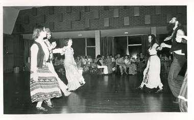
Photograph - Black and white photograph, Kew Festival Colonial Dance 1979, 1979
Kew Festival Colonial Dance held at the Kew Town Hall (later used as a library)city of kew, kew festival, colonial dance, kew town hall -
 Ballarat Heritage Services
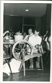
Photograph - Black and white photograph, Spinning Wool during the Kew Festival Colonial Dance, 1979, 1979
Jonathan Benyei spins wool during the Kew Festival Colonial Dance held at the Kew Town Hall. He is warched by his mother Dorothy Benyei. city of kew, kew festival, colonial dance, kew town hall, jonathan benyei, dorothy benyei, spinning wool -
 Ballarat Heritage Services
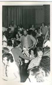
Photograph - Black and white photograph, Kew Festival Colonial Dance 1979, 1979
The music was supplied for this dance by the Bushwhackers.Cr Alan Hutchinson is central in this photograph of the Kew Festival Colonial Dance held at the Kew Town Hall (later used as a library). city of kew, kew festival, colonial dance, kew town hall, alan hutchison, bushwhackers -
 Ballarat Heritage Services
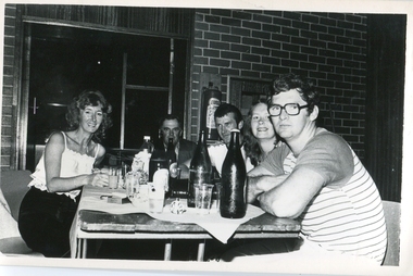
Photograph - Black and white photograph, Kew Festival Colonial Dance 1979, 1979
The music was supplied for this dance by the Bushwhackers.A table ot people at the Kew Festival Colonial Dance held at the Kew Town Hall (later used as a library). They include Martin O'Toole and Lawrence O'Toole who were both World Champian Woodcutters. city of kew, kew festival, colonial dance, kew town hall, bushwhackers, martin o'toole, lawrence o'toole -
 Ballarat Heritage Services
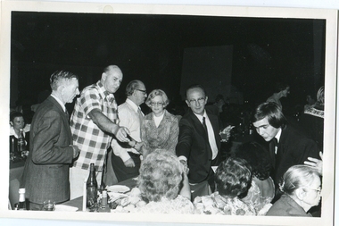
Photograph - Black and white photograph, Kew Festival Music Hall, 1979, 1979
The music was supplied for this dance by the Bushwhackers.A group at the Kew Festival Music Hall. From left to right: ? , Jack Joseph, ? , Kathleen Gervasoni (City of Kew Mayoress), Cr Jack Gervasoni (Mayor)city of kew, kew festival, colonial dance, kew town hall, bushwhackers, martin o'toole, lawrence o'toole -
 Ballarat Heritage Services
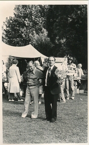
Photograph - Black and white photograph, Kew Festival, 1979
Two men stand in the Alexandria Gardens during the Kew Festival .city of kew, kew festival, colonial dance, kew town hall, bushwhackers, martin o'toole, lawrence o'toole -
 Kew Historical Society Inc
Plan, Melbourne & Metropolitan Board of Works. Borough of Kew Detail Plan No.1579, 1904
The Melbourne and Metropolitan Board of Works (MMBW) plans were produced from the 1890s to the 1950s. They were crucial to the design and development of Melbourne's sewerage and drainage system. The plans, at a scale of 40 feet to 1 inch (1:480), provide a detailed historical record of Melbourne streetscapes and environmental features. Each plan covers one or two street blocks (roughly six streets), showing details of buildings, including garden layouts and ownership boundaries, and features such as laneways, drains, bridges, parks, municipal boundaries and other prominent landmarks as they existed at the time each plan was produced. (Source: State Library of Victoria). This plan forms part of a large group of MMBW plans and maps that was donated to the Society by the Mr Poulter, City Engineer of the City of Kew in 1989. Within this collection, thirty-five hand-coloured plans, backed with linen, are of statewide significance as they include annotations that provide details of construction materials used in buildings in the first decade of the 20th century as well as additional information about land ownership and usage. The copies in the Public Record Office Victoria and the State Library of Victoria are monochrome versions which do not denote building materials so that the maps in this collection are invaluable and unique tools for researchers and heritage consultants. A number of the plans are not held in the collection of the State Library of Victoria so they have the additional attribute of rarity.Original survey plan, issued by the MMBW to a contractor with responsibility for constructing sewers in the area identified on the plan within the Borough of Kew. The plan was at some stage hand-coloured, possibly by the contractor, but more likely by officers working in the Engineering Department of the Borough and later Town, then City of Kew. The hand-coloured sections of buildings on the plan were used to denote masonry or brick constructions (pink), weatherboard constructions (yellow), and public buildings (grey). While MMBW Plan No.1579 does not include many buildings, those that it does show are significant to Kew’s history. These include the ‘Kew [Railway] Station’ in Denmark Street and the ‘Recreation Hall’ and rear courts off Wellington Street. The plan shows the outline of the Recreation Hall, constructed in 1880, at the rear of which is listed a bowling green, two tennis courts, a ‘skittle alley’ and a pavilion. When the Hall was first built, the Kew Cricket Club occupied an adjacent ground, however in 1885 this was acquired by the State Government as the future location of the Kew Railway Station. The Plan also shows a single oval at Xavier College. This oval was completed in 1883. One of the current ovals conforms to this oval’s original shape and position in the school grounds.melbourne and metropolitan board of works, detail plans, maps - borough of kew, mmbw 1579, cartography -
 Kew Historical Society Inc
Plan, Melbourne & Metropolitan Board of Works : Borough of Kew : Detail Plan No.1581, 1904
The Melbourne and Metropolitan Board of Works (MMBW) plans were produced from the 1890s to the 1950s. They were crucial to the design and development of Melbourne's sewerage and drainage system. The plans, at a scale of 40 feet to 1 inch (1:480), provide a detailed historical record of Melbourne streetscapes and environmental features. Each plan covers one or two street blocks (roughly six streets), showing details of buildings, including garden layouts and ownership boundaries, and features such as laneways, drains, bridges, parks, municipal boundaries and other prominent landmarks as they existed at the time each plan was produced. (Source: State Library of Victoria)This plan forms part of a large group of MMBW plans and maps that was donated to the Society by the Mr Poulter, City Engineer of the City of Kew in 1989. Within this collection, thirty-five hand-coloured plans, backed with linen, are of statewide significance as they include annotations that provide details of construction materials used in buildings in the first decade of the 20th century as well as additional information about land ownership and usage. The copies in the Public Record Office Victoria and the State Library of Victoria are monochrome versions which do not denote building materials so that the maps in this collection are invaluable and unique tools for researchers and heritage consultants. A number of the plans are not held in the collection of the State Library of Victoria so they have the additional attribute of rarity.Original survey plan, issued by the MMBW to a contractor with responsibility for constructing sewers in the area identified on the plan within the Borough of Kew. The plan was at some stage hand-coloured, possibly by the contractor, but more likely by officers working in the Engineering Department of the Borough and later Town, then City of Kew. The hand-coloured sections of buildings on the plan were used to denote masonry or brick constructions (pink), weatherboard constructions (yellow), and public buildings (grey). The streets and built structures in this plan were surveyed in 1903 and released to contractors in 1904. In addition to the designation of building types by colour, the plan includes detailed descriptions of land use and ownership. While many buildings remain from this period, a number of the buildings represented have been demolished including the original Kew Town Hall, and the Congregational and Roman Catholic churches in Walpole Street. While the mansion ‘Illapa’ in Princess Street is still extant – now part of ‘Rylands’ – the neighbouring mansion ‘Elsmere’ was demolished some decades ago. Rivalling Illapa and Elsmere in size were two mansions in Walpole Street, one named on the plan as ‘Gnarlbine’. Over time, Kew Junction and the south side of High Street have been reconfigured and widened, so that the commercial buildings on the corner of Princess and High Street no longer exist. A surprising feature of this part of central Kew to the northwest of Kew Junction is the amount of vacant land. In a number of cases, this land is noted by the contractor as used for vegetable gardens.melbourne and metropolitan board of works, detail plans, maps - borough of kew, mmbw 1581, cartography -
 Kew Historical Society Inc
Plan, Melbourne & Metropolitan Board of Works : Borough of Kew : Detail Plan No.1588, 1904
The Melbourne and Metropolitan Board of Works (MMBW) plans were produced from the 1890s to the 1950s. They were crucial to the design and development of Melbourne's sewerage and drainage system. The plans, at a scale of 40 feet to 1 inch (1:480), provide a detailed historical record of Melbourne streetscapes and environmental features. Each plan covers one or two street blocks (roughly six streets), showing details of buildings, including garden layouts and ownership boundaries, and features such as laneways, drains, bridges, parks, municipal boundaries and other prominent landmarks as they existed at the time each plan was produced. (Source: State Library of Victoria)This plan forms part of a large group of MMBW plans and maps that was donated to the Society by the Mr Poulter, City Engineer of the City of Kew in 1989. Within this collection, thirty-five hand-coloured plans, backed with linen, are of statewide significance as they include annotations that provide details of construction materials used in buildings in the first decade of the 20th century as well as additional information about land ownership and usage. The copies in the Public Record Office Victoria and the State Library of Victoria are monochrome versions which do not denote building materials so that the maps in this collection are invaluable and unique tools for researchers and heritage consultants. A number of the plans are not held in the collection of the State Library of Victoria so they have the additional attribute of rarity.Original survey plan, issued by the MMBW to a contractor with responsibility for constructing sewers in the area identified on the plan within the Borough of Kew. The plan was at some stage hand-coloured, possibly by the contractor, but more likely by officers working in the Engineering Department of the Borough and later Town, then City of Kew. The hand-coloured sections of buildings on the plan were used to denote masonry or brick constructions (pink), weatherboard constructions (yellow), and public buildings (grey). This plan shows the original configuration of the Kew Post Office, Court House and Police Station, which had opened in 1888. This configuration was to essentially remain until the purchase of the Court House and Police Station by the City of Boroondara in 2007 and its subsequent renovation. Interestingly, the MMBW surveyors incorrectly labelled parts of the complex. In the triangle in front of the Post Office, before the erection of the Kew Cenotaph in 1925, was located a lawn and the Queen Victoria Jubilee Fountain. While many of the shops on the south side of High street had been constructed by 1903 a number of sites were still used as vegetable gardens. Further along High Street, on the corner of Charles Street, the Salvation Army Barracks can be seen on the plan. These Barracks predate the later Citadel and ‘Young People’s Hall’ that were opened in 1919. At 22 Charles Street can be seen the house of James Venn Morgan. Hailed as the ‘father of Kew’, Morgan arrived in Melbourne in 1840. He was first engaged as a bookmaker, but a fortunate venture on the goldfields enabled him to purchase land in Kew. He conducted a market garden and dairy in Kew for many years.melbourne and metropolitan board of works, detail plans, maps - borough of kew, mmbw 1588, cartography -
 Kew Historical Society Inc
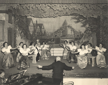
Photograph, Cast Members in The Maid of the Mountains / by Harold Fraser-Simson, 1957
The Arthur Dear Collection is a comprehensive collection of theatrical ephemera relating to performances by theatrical and musical organisations from within and outside the former City of Kew who performed at venues in Kew during the 1950s and 1960s.Historic photograph of a theatre productionPhotograph of a performance or a rehearsal of The Maid of the Moutains, performed by the Kew Light Opera Company in the Kew Recreation Hall in 1957.arthur dear collection, kew light opera company, the maid of the mountains -
 Kew Historical Society Inc
Photograph - 8 roomed DF Brick Villa, Kew, J E Barnes, c.1920
Subdivision plans are historically important documents used as evidence of the growth of suburbs in Australia. They frequently provide information about when the land was sold on which a built structure was subsequently constructed as well as evidence relating to surveyors and real estate and financial agents. The numerous subdivision plans in the Kew Historical Society's collection represent working documents, ranging from the initial sketches made in planning a subdivision to printed plans on which auctioneers or agents listed the prices for which individual lots were sold. In a number of cases, the reverse of a subdivision plan in the collection includes a photograph of a house that was also for sale by the agent. These photographs provide significant heritage information relating house design and decoration, fencing and household gardens. The photograph is of additional aesthetic significance as it was photographed by J. E. Barnes. Josiah Earl Barnes is a nationally significant photographer. He was also the most important photographer to have worked in Kew. He was active as a photographer in the district from c.1906 until his death in 1921. Best known as 'the Embarkation Photographer' (see the Australian War Memorial collection), J. Earl Barnes was also the official photographer employed by the Borough (and later Town, then City) of Kew. He clearly also completed commercial jobs for local businesses, as is the case in this photograph of a house for a local real estate and financial agent.A photograph, mounted on board of a double fronted Federation-era brick villa in Kew, photographed for a local real estate agent and financier by J. E. Barnes of Kew. On the reverse of the photograph is a subdivision plan for the Normanby Estate, East Kew - 2016.0039.1. As can be seen from the image, there is a large tear on the surface of the photograph.The brown card on which the photograph is mounted includes the following handwritten description, which may aid the identification of the house: "Kew, 3 minutes from tram, 8 roomed DF Brick Villa, tile roof including two attics, sleepout, bathroom, heater, E Light, Entrance Hall, double doors, leadlights, laundry, garden, lawns, land 75 x 170, 1975 pounds". Also photographers inscription on mount, lower left: J. E. Barnes / Photo / Phone 1966 Haw. KEW.j. e. barnes, josiah earl barnes, j. earl banes - photographer, architecture - federation style, houses - kew, real estate photographs -
 Kew Historical Society Inc
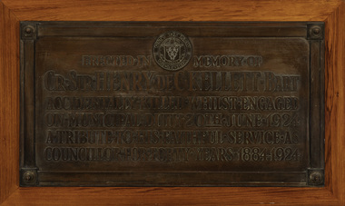
Plaque - Cr. Sir Henry de C. Kellett Bart, 1924
The plaque to Henry Kellett was originally mounted in the vestibule of the Kew Town Hall in Walpole StreetThe plaque was once part of the Municipal Collection of the former City of Kew and was presented to the Kew Historical Society before the move from the Walpole Street (Kew) Town Hall to new Civic offices in Charles Street in 1971.Bronze funeral plaque commemorating the life and death of Sir Henry de Castres Kellett, who was killed in a traffic accident in 1924. The plaque bears an extensive dedication and is mounted on a wooden mount that was previously attached to a wall in the Walpole Street [Kew] Town Hall ."City of Kew Victoria [logo] / Erected in Memory of / Cr. Sir Henry de C. Kellett Bart. / Accidentally Killed Whilst Engaged / On Municipal Duty 20th June 1924 / A Tribute to His Faithful Service as / Councillor for Forty Years 19884-1924"sir henry de castres kellett, mayors of kew (vic), councillors of kew (vic) -
 Kew Historical Society Inc
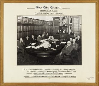
Photograph, Stuart Tompkins, Kew City Council Meeting, Cr Marie Dalley, O.B.E., J.P., Mayor, 1955
Cr. Marie Dalley was the first female mayor of Kew in 1954-55. The photograph shows the interior of the Council Chamber in the 1950s.An original photograph of Cr. Marie Dalley and councillors in 1955. The photograph was once part of the Municipal Collection of the former City of Kew and was presented to the Kew Historical Society in 1989.Framed photograph of the Kew City Council at a meeting in the Council Chamber of the Walpole Street {Kew] Town Hall in August 1955; the Mayor Cr. Marie Dalley chairing the meeting. Names of the councillors and council staff are inscribed on the mount. mayors of kew (vic), kew city council - 1955, council chamber - walpole street (kew) town hall, kew (vic.) — municipal collection -
 Kew Historical Society Inc
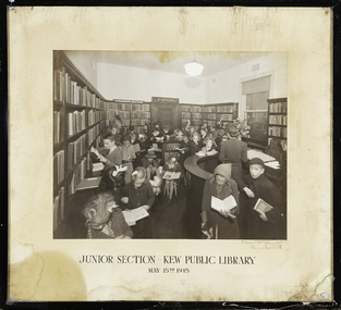
Photograph, C Stuart Tompkins, Junior Section, Kew Public Library, 15 May 1945
1860: Kew's first library was the Kew Literary and Scientific Society, which opened on 6 August 1860. 1884: Kew Town Hall was extended and the library transferred to a room on the upper floor. This was not an ideal arrangement as the room was required for Council purposes. 1904: A cottage adjoining Kew Town Hall was purchased for use as a library. 1937: The library was closed for a major overhaul of stock and renovation of the building. It reopened in December 1937 and remained there for more than 35 years. 1973: When the Civic Centre opened in Charles Street, Kew, the library moved in. 1987: Kew Library moved to its current location in the converted city hall, overlooking the beautiful Alexandra Gardens. The library was officially opened at this site on Friday 23 October 1987 by the Mayor of Kew, Cr James Tutt. (Source: Boroondara Library Service)Early original photograph of a children's library service taken by a notable Melbourne photographerOriginal photograph, in original frame, of the Junior Section of the Kew Public Library in Walpole Street, Kew. The photograph was taken by Stuart Tompkins who was the photographer of choice by the City of Kew from the 1930s to the 1960s. The details of the photograph are inscribed on the water-damaged mount, with the photographers signature at lower right. . "Junior Section, Kew Public Library, May 15th 1945"kew public library, photographers - c. stuart tompkins - camberwell (vic), children's libraries -
 Kew Historical Society Inc
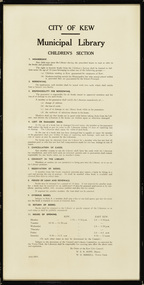
Document, City of Kew, City of Kew Municipal Library, Children's Section, 1953
1860: Kew's first library was the Kew Literary and Scientific Society, which opened on 6 August 1860. 1884: Kew Town Hall was extended and the library transferred to a room on the upper floor. This was not an ideal arrangement as the room was required for Council purposes. 1904: A cottage adjoining Kew Town Hall was purchased for use as a library. 1937: The library was closed for a major overhaul of stock and renovation of the building. It reopened in December 1937 and remained there for more than 35 years. 1973: When the Civic Centre opened in Charles Street, Kew, the library moved in. 1987: Kew Library moved to its current location in the converted city hall, overlooking the beautiful Alexandra Gardens. The library was officially opened at this site on Friday 23 October 1987 by the Mayor of Kew, Cr James Tutt. (Source: Boroondara Library Services)Historically and socially significant set of regulations governing the use of the children's library in Kew in the early 1950sOriginal framed rules and regulations of the junior section of the Kew Library, dated 16.6.1953, authorised by the Mayor (W.E.R. Hope) and Town Clerk (W.D.Birrell). The document also lists opening hours of the Kew and East Kew branches.kew public library - kew (vic), kew public library - east kew (vic), city of kew - library guidelines -
 Kew Historical Society Inc
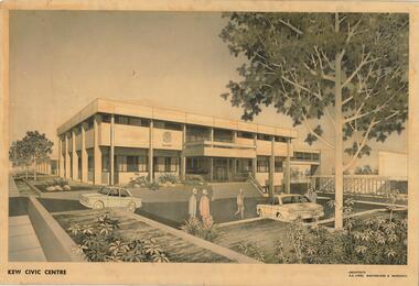
Drawing, AK Lines, Macfarlane & Marshall, Kew Civic Centre, c.1970
The Kew Civic Centre (A K Lines, MacFarlane & Marshall, 1972) was built next to the Kew Civic Hall (A C Leith & Bartlett, 1960) on the site of the former mansion Ordsall (later renamed South Esk). Whereas the entrance to the Civic Hall was positioned off Civic Drive, the main entrance to the Civic Centre faced Cotham Road, as shown in the undated perspective drawing of the proposed building. The Civic Hall was used for public functions and performances, while the Civic Centre was used for civic offices. It also contained the Council Chamber. The building opened in 1972, following the relocation of the councillors and council officers from the former Town Hall in Walpole Street (now a Woolworth's supermarket). Following the amalgamation of the former City of Kew into the City of Boroondara in 1994, the Civic Centre was sold to Trinity Grammar School. The exterior of the Centre has been modified by Trinity Grammar.A report for Heritage Victoria (date) describes how two architectural firms dominated the designs for new civic buildings in Victoria during the post war period. The report claims that: "An interesting sub-theme in the erection of post-war municipal offices in Victoria is that a considerable proportion were designed by the same three or four Melbourne-based architectural firms, who established themselves as the leading specialists in this type of work. The two most prolific firms in this regard were A K Lines, MacFarlane & Marshall, and A C Leith & Bartlett; both, in fact, had made names for themselves as designers of local government offices prior to the Second World War. Lines' office, for example had designed the Eltham Shire Offices in 1941, while Leith's firm had been responsible for the celebrated Heidelberg Town Hall in 1937). Both practices parleyed this early experience into a lucrative post-war career, designing numerous municipals offices well into the 1970s." (Survey of Post-War Built Heritage in Victoria, Built Heritage Pty Ltd, 2010.) The perspective drawing importantly captures the original design and function of the exterior of the building and its public entrance.Hand-coloured perspective sketch of the new Kew Civic Centre, completed in 1972 to designs by A K Lines, MacFarlane & Marshall; and located on the corner of Charles Street and Cotham Road, Kew. The sketch represents the front elevation of the building and its relation to the preexisting Kew Civic Hall at right. The three storey building features strong vertical concrete buttresses that extend across the three levels. KEW CIVIC CENTRE / A K LINES, MACFARLANE & MARSHALLkew civic centre, a.k. lines, macfarlane & marshall, architectural drawings, civic buildings -- kew (vic.), town hall -- kew (vic) -
 Kew Historical Society Inc
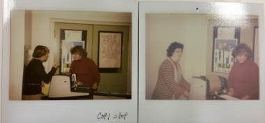
Photograph - 'Copy Shop', Old Masonic Hall, Walpole Street
... facilities -- city of kew masonic hall -- kew (vic.) front: "Copy ...The 'Copy Shop' in Walpole Street, Kew was located in the former Masonic Hall. It was a community operated facility. The 'shop' was designed for use by groups to run off leaflets or newsletters. It also served as a community space where people could drop in for a coffee and leave leaflets and information about events in the City of Kew. Two polaroid photographs, Thea Sartori in a red jumper is in both photographs. The woman in the pink cardigan is Aileen Cahill. Both photos were taken at the 'Copy Shop' in the old Masonic Hall [demolished] in Walpole Street. front: "Copy Shop"copy shop - walpole street - kew (vic), community facilities -- city of kew, masonic hall -- kew (vic.) -
 Kew Historical Society Inc
Archive (Sub-series) - Subject File, Buildings (Kew), 1964
Various partiesReference, Research, InformationSecondary Values (KHS Imposed Order)Subject file containing newspaper articles/clippings, research and correspondence from and to the Society. The earliest item, dating from 1964 is a letter from the Society to the City of Kew seeking Council support for the use of Ellesmore, 80 Princess Street as a cultural heritage centre. Other items of correspondence relate to the Masonic Hall (Walpole Street), Fernhurst, Southesk, Roberts House, Park Hill, Butleigh Wooton, Villa Alba, D’Estaville, Charleville, Roseneath, Merridale, La Verna, Otira, Raheen, Willsmere, Holy Trinity Church. Some of these letters contain information about construction of the buildings and architects. In addition to this correspondence, the file includes brief undated research notes on the Clock Tower at the Kew Cemetery, Tarring, Southesk, the Alexandra Gardens, Studley House (Burke Hall), Ellesmore, the Masonic Hall, Xavier College, Genazzano, Trinity Grammar, Carey Baptist College, Abbotsford, Fernhurst, Illapa, Madford, Morganville, Otira, Parkhill, Monnington, Field Place, Lalla Rookh, Merridale, Kew Mental Hospital, and D’Estaville.buildings -- kew (vic.), heritage -- kew (vic.)buildings -- kew (vic.), heritage -- kew (vic.) -
Kew Historical Society Inc
Archive (Sub-series) - Subject File, Citizen's Advice Bureau (Kew), 1975
... Citizens Advice Bureau that was located at the City Hall, Cotham... the Kew Citizens Advice Bureau that was located at the City Hall ...Various partiesReference, Research, InformationSecondary Values (KHS Imposed Order)Subject file containing information about the Kew Citizens Advice Bureau that was located at the City Hall, Cotham Road, Kew. The file includes various items including a newsletter from 1979, minutes of meetings of the Bureau in 1979, a meeting relating to ‘Kewcare’, and a document from 1975 entitled ‘Kew-Hawthorn Information System', which lists the areas (eg derelicts, drug dependency, firewood for aged etc) covered by the Bureau.citizens advice bureau - city of kew, city of kew - resident servicescitizens advice bureau - city of kew, city of kew - resident services -
Kew Historical Society Inc
Archive (Sub-series) - Subject File, Community Centre (Kew), 1958
Various partiesReference, Research, InformationSecondary Values (KHS Imposed Order)Subject file containing correspondence between office-bearers of the Kew Historical Society and the City of Kew relating to the possibility of purchasing historic buildings from demolition and for use as a community centre and historical society premises or museum. Properties discussed included 14/16 Princess Street and the hall (Neama) on the site of St Paul’s School.community centres -- kew (vic), historical museums - proposedcommunity centres -- kew (vic), historical museums - proposed -
 Kew Historical Society Inc
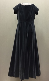
Clothing - Grey Velvet Evening Dress, 1960
The Fashion & Design collection of the Kew Historical Society includes examples of women’s, men’s, children’s and infants’ clothing from the 18th, 19th and 20th centuries. Items in the collection were largely produced for, or purchased by women in Melbourne, and includes examples of outerwear, protective wear, nightwear, underwear and costume accessories.Kew was declared a separate municipality in 1860. To commemorate this, a number of events were held in Kew, including a Centenary Dinner Dance in 1960 at which the speakers were Sir Robert Menzies and Cr WHS Dickinson. As the Mayoress, Mrs Doris Dickinson accompanied her husband, wearing this dress. Evening dress, made of unlined grey velvet, worn by the Mayoress, Mrs Doris Dickinson, (wife of Cr WHS Dickinson), to the Kew Centenary Dinner Dance in the Kew Civic Hall. The dress has matching cream kid gloves. The dress was donated by Mrs Judith Goodes, a daughter of Cr. and Mrs. Dickinson.cr whs dickinson, mrs doris dickinson, australian fashion - 1960s, women's clothing - 1960s, city of kew centenary - 1960, evening wear, evening dresses -
Kew Historical Society Inc
Archive (Sub-series) - Subject File, Kew Historical Society, Grip of Time, 1982
Various partiesReference, Research, InformationSecondary Values (KHS Imposed Order)Subject file containing both primary and secondary sources relating to the sculpture by Peter Schipperheyn (b.1955) - Grip of Time (1979) - installed on the north wall of the Kew Town Hall (now the Kew Library) in 1983. Mrs Laurel Abercrombie, a Kew resident, donated the sculpture to the City of Kew in 1982, and it formed part of the ‘municipal collection’ of the former City of Kew (now City of Boroondara). A note in the file records that prior to its installation on its current site; it was attached to a brick wall at the side of Abercrombie Galleries, Johnson Street, Collingwood. It was restored by the sculptor c.1996. The file contains two colour photographs of the sculpture and newspaper articles recording controversy at the time of its installation. The file also contains correspondence between the Society and the City of Boroondara relating to the plaque that was beside the sculpture.kew historical society - archives, kew library, kew civic hall, kew town hall, grip of time, peter schipperheyn (1955-), artworks - kew (vic), city of kew - municipal collectionkew historical society - archives, kew library, kew civic hall, kew town hall, grip of time, peter schipperheyn (1955-), artworks - kew (vic), city of kew - municipal collection -
 Kew Historical Society Inc
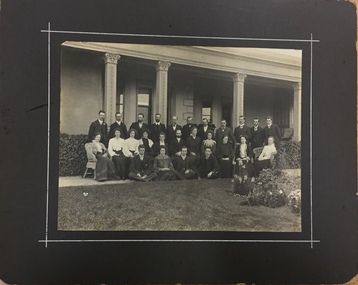
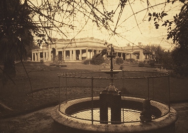
Photograph, Kew Congregational Church members at South Esk, circa 1900, c.1900
Ordsall, renamed Southesk in the 20th century was built for John Halfey in or before 1865. The house was rebuilt in the 1870s to designs by architect Michael Hennessy. In 1882 the house was redecorated by the firm of Culls Hill & Co., who hired the artists 'Mr Vandenbrandt' and 'Signor Rizzi" to paint the ceilings of the ballroom and the drawingroom. The artistic triumph was described in detail in The Argus, 30 October, 1882. In 1947, Southesk was purchased by the Kew City Council. For 23 years it was used as a meeting place for community groups. The house was then demolished in 1970 to make way for a new Town Hall.This is the earliest known photograph of Ordsall / South Esk, a significant mansion in Kew, built for John Halfey and now demolishedMembers of the Kew Congregational Church in front of one of the verandas of Southesk, circa 1900.congregational church - kew (vic), south esk - south esk - ordsall - kew (vic) -
 Kew Historical Society Inc
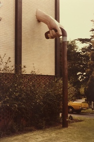
Photograph, 'The Grip of Time', Kew Civic Hall, c.1973
Two colour polaroid photographs of the sculpture 'The Grip of Time' on the north exterior wall of the Kew Library. At left is the coat of arms of the City of Kew. The sculpture was purchased and donated to the City of Kew by Mrs Laurel Abercrombie. The artwork was created by Peter Schipperheyn.public sculpture - kew (vic), kew civic hall, kew library, the grip of time, public art -
 Kew Historical Society Inc
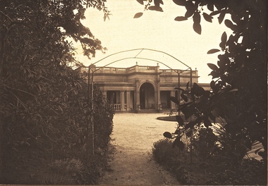
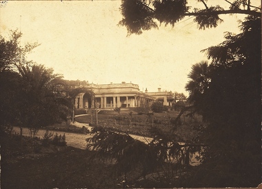
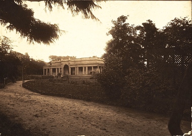
Photograph - 'Southesk' (formerly 'Ordsall'), Cotham Road, 1920s
Ordsall was originally built for John Halfey, second Chairman of Kew, and sold after his death to the Carnegie family who renamed it ‘South Esk'. The Carnegie family mounted a defence of their property when the City of Kew sought to compulsorily acquire the site for a new town hall in the 1930s. The house and land were later acquired by Council in 1947 and demolished in 1970. The present Kew Library and the former Council Offices (now owned by Trinity Grammar) are located on the site.One of the earliest photographs of 'Southesk' and its gardens. The house was of statewide significance because of its historical association with John Halfey. It was artistically significant due to its elaborate interiors, decorated by Cullis Hill & Co in the 1880s. Sepia photograph mounted on brown card of "Southesk' (formerly known as 'Ordsall'). The single-storey Italianate facade of the house can be seen surrounded by an extensive garden. The point-of-view of the camera is from Cotham Road.john halfey, david carnegie, southesk - south esk - ordsall -
 Kew Historical Society Inc
Photograph - 'Southesk' (formerly 'Ordsall'), Cotham Road, 1920s
Ordsall was originally built for John Halfey, second Chairman of Kew, and sold after his death to the Carnegie family who renamed it ‘South Esk'. The Carnegie family mounted a defence of their property when the City of Kew sought to compulsorily acquire it as the site for a new town hall in the 1930s. The house and land were later acquired by Council in 1947 and demolished in 1970. The present Kew Library and the former Council Offices (now owned by Trinity Grammar) are located on the site.One of the earliest photographs of 'Southesk' and its gardens. The house was of statewide significance because of its historical association with John Halfey. It was artistically significant due to its elaborate interiors, decorated by Cullis Hill & Co in the 1880s. Sepia photograph mounted on brown card of "Southesk' (formerly known as 'Ordsall'). The single-storey Italianate facade of the house can be seen surrounded by an extensive garden. The point-of-view of the camera is from Cotham Road.john halfey, david carnegie, southesk - south esk - ordsall -
 Kew Historical Society Inc
Photograph - 'Southesk' (formerly 'Ordsall'), Cotham Road, 1920s
Ordsall was originally built for John Halfey, second Chairman of Kew, and sold after his death to the Carnegie family who renamed it ‘South Esk'. The Carnegie family mounted a defence of their property when the City of Kew sought to compulsorily acquire it as the site for a new town hall in the 1930s. The house and land was later acquired by Council in 1947 and demolished in 1970. The present Kew Library and the former Council Offices (now owned by Trinity Grammar) are located on the site.One of the earliest photographs of 'Southesk' and its gardens. The house was of statewide significance because of its historical association with John Halfey. It was artistically significant due to its elaborate interiors, decorated by Cullis Hill & Co in the 1880s. Sepia photograph mounted on brown card of "Southesk' (formerly known as 'Ordsall'). The single-storey Italianate facade of the house can be seen surrounded by an extensive garden. The point-of-view of the camera is from Cotham Road.john halfey, david carnegie, southesk - south esk - ordsall -
 Kew Historical Society Inc
Photograph - 'Southesk' (formerly 'Ordsall'), Cotham Road, 1920s
Ordsall was originally built for John Halfey, second Chairman of Kew, and sold after his death to the Carnegie family who renamed it ‘South Esk'. The Carnegie family mounted a defence of their property when the City of Kew sought to compulsorily acquire it as the site for a new town hall in the 1930s. The house and land were later acquired by Council in 1947 and demolished in 1970. The present Kew Library and the former Council Offices (now owned by Trinity Grammar) are located on the site.One of the earliest photographs of 'Southesk' and its gardens. The house was of statewide significance because of its historical association with John Halfey. It was artistically significant due to its elaborate interiors, decorated by Cullis Hill & Co in the 1880s. Sepia photograph mounted on brown card of "Southesk' (formerly known as 'Ordsall'). The single-storey Italianate facade of the house can be seen surrounded by an extensive garden. The point-of-view of the camera is from Cotham Road.david carnegie, john halfey, southesk - south esk - ordsall -
 Kew Historical Society Inc
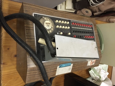
Equipment, City of Kew Switchboard, 1960s
The local government area of Kew was established in 1860. Through successive incarnations as a municipality, borough, town and city, its headquarters, at least until 1972, were located in a town hall in Walpole Street. In 1994, the city was amalgamated into a new City of Boroondara. This items served as telephone equipment - a switchboard - in the City's civic offices.Switchboard used in the City of Kew's Civic Offices in Walpole Street. The redundant equipment was donated to the Society in 1988.office equipment, city of kew, switchboards