Showing 3669 items
matching landscape.
-
 University of Melbourne, Burnley Campus Archives
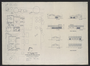
Plan, Fooks Martin Sandow Pty. Ltd, Victorian College of Agriculture & Horticulture Burnley Campus New Workshop, Equipment Store, & Landscape Construction Facilities, 1996
Plans by Fooks Martin Sandow, August 1996. Scale 1:200. (1) New Mechanics Workshop, New Equipment Store, etc. and Landscape Construction, with Elevations. (2) Layout of Equipment Store - where each piece of equipment to be placed.vcah, fooks martin sandow, equipment store, landscape construction -
 Eltham District Historical Society Inc
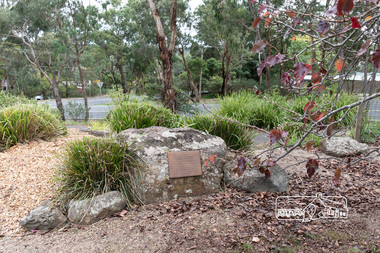
Photograph, Peter Pidgeon, Memorial to Gordon Craig Ford, Landscape Designer, Eltham Cemetery, Victoria, 5 April 2021
Gordon Ford was a conservationist and a pioneer of natural-style landscaping. He came to Eltham in 1948 and bought a block of land in John Street extending through to Pitt Street. Artist Peter Glass lived opposite in John Street. Early on, Gordon worked for Alistair Knox on construction of the mudbrick Busst house amongst others. At the same time, with the help of friends including artist Clifton Pugh, he progressively built his own house ‘Fülling’, which "grew like Topsy" utilising a variety of second-hand materials. His main focus, which became his life-long occupation, was garden landscaping. Inspired by Edna Walling and Ellis Stones, he sought to reflect the bush settings of rural Victoria where he had grown up. Commissions included Monash University and countless industrial sites but designing for the archetypal quarter-acre block gave him the most satisfaction. He had a huge impact on the look of gardens in Australia from the 1950s, creating seemingly natural bush environments by carefully integrating indigenous and exotic plantings. Gordon died in 1999 and is buried in Eltham Cemetery; the gravesite is marked by a plaque. Another plaque (away from his grave) notes his landscaping design work within the cemetery grounds and at Alistair Knox Park. Gordon Craig Ford Landscape Designer 30. 8 .1918 - 16. 6. 1999 Eltham Cemetery Trustee fom 1987 - 1999 Gordon settled in Eltham in 1948 He was a conservationist and a pioneer of natural style landscaping, continuing design and construction until his death. His local work and influence can be seen in many private gardens, the Eltham Cemetery and the Alistair Knox Park.Born Digitaleltham cemetery, gravestones, gordon craig ford -
 University of Melbourne, Burnley Campus Archives
Administrative record - Letters, Landscape Design Acceptances 1977
course, students, e b littlejohn, landscape design, certificate -
 Glenelg Shire Council Cultural Collection
Painting, Harry Rosengrave, (Untitled - Landscape), 1969
Caltex $500 Prizewinner at Portland Arts Festival - retained for Portland Collection.Dense landscape depiction - bushland in vivid blue and green shades. There is a clearing on the left with 3 houses and possibly a figure in the centre of the clearing. Blue sky with a long cloud. Mounted in a tan-coloured matt in a wooden frame with a faux-distressed gold finish.Front: H. Rosengrave 69 (lower right). Back: Top right - yellow sticker "1969-". Bottom centre - "Gary Hayman. Picture framer. 41 Julia Street, Portland, 33-5. 055 233154. Custom framing, framed printed, photos and oils."landscape, bush, bushland -
University of Melbourne, Burnley Campus Archives
Plan - Photocopy, Royal Park Landscape Development Plan, 1985
Photocopies of plans prepared for the City of Melbourne, November 1985 by Laceworks Landscape Collaborative Maunsell and Partners. (1) P & G DRG No 3/11 1 Longterm Parking Zoo. (2) P & G DRG No 3/12 0 Existing Conditionsroyal park, landscape, city of melbourne, zoological gardens, laceworks landscape collaborative maunsell and partners -
University of Melbourne, Burnley Campus Archives
Work on paper (item) - Student Work, Xueli Ruan, Sunbury Crescent Landscape Design, 2016
Created as an assignment for HORT90035 'Landscape Construction and Graphics,' a subject at Burnley Horticultural College coordinated by Andrew Laidlaw. There may be a sheet missing because usually these assignments would have three sheets. There was however a marking rubric found with the project. assignment, landscaping, burnley, 'landscape construction and graphics' -
University of Melbourne, Burnley Campus Archives
Work on paper (item) - Student Work, Lucas McGarrigle, Landscape Design Plan, 2018
Made as an assignment for HORT90035, a subject at Burnley Horticultural College coordinated by Andrew Laidlaw. assignment, landscaping, burnley horticultural college, landscape construction and graphics, hort90035 -
 University of Melbourne, Burnley Campus Archives
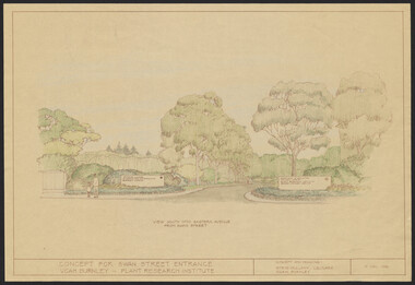
Plan, Landscape Plan Swan Street Entrance. VCAH Burnley and Plant Research Institute, 1988-1998
(1) Concept and Drawing by Steve Mullany, Lec turer V.C.A.H. Burnley 9 Dec 1988. Handdrawn. 1 coloured, 2 copies and 4 tracing paper sketches. (2) Landscape Plan by Steve Mullany 3 Feb 1989. Handdrawn. Includes Plant Plan. 2 copies on tracing paper. 3 copies original on paper with some additional notation. (30 Project Eden, Swan Street, Richmond - Landscape Plan LA2 Project No 682 by Mark McWha Pty Ltd Nov 1997. Photocopy. Includes Irrigation and Plant Schedule. (4) Swan St Frontage Planting Scheme by P. Tulk for AMRAD. Coloured. 19/2/1998. -
University of Melbourne, Burnley Campus Archives
Work on paper (item) - Student Work, E. Johnston, Mooney Residence Landscape Design, September 2017
Submitted as an assignment for an unspecified subject at Burnley Horticultural College, probably HORT90035 coordinated by Andrew Laidlaw. assignment, burnley horticultural college -
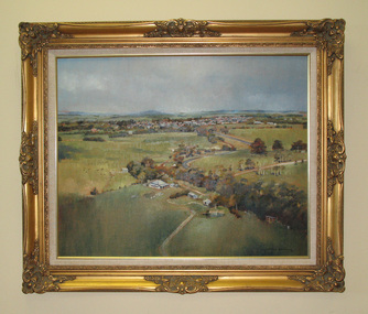 South Gippsland Shire Council
Painting. Oil, Leongatha Landscape
Framed oil painting titled: "Leongatha Landscape" painted by Harris Smith. Features scene of farming property in the foreground and township of Leongatha in the distance. Rolling hills, flora, buildings and sky. Gold decorative frame with cream textured vinyl window mount. Painted in shades of browns, greens, blues and yellows. -
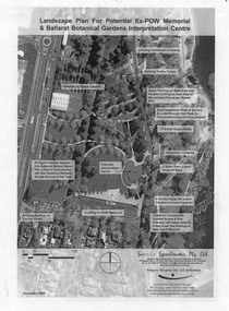 Ballarat Tramway Museum
Document - Photocopy, Gregory Burgess Pty Ltd and Architects and, "Landscape Plan for Potential Ex-POW Memorial & Ballarat Botanical Gardens Interpretation Centre", Nov. 2005
Three page photocopy consultation document titled "Landscape Plan for Potential Ex-POW Memorial & Ballarat Botanical Gardens Interpretation Centre" showing concept plans for the development to the east of the tram depot and for the POW memorial. The project did not proceed. Prepared by Gregory Burgess Pty Ltd, Architects, November 2005.trams, tramways, gardens, depot, botanical gardens -
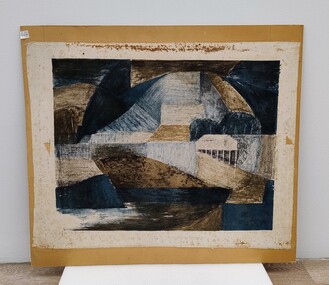 Royal Australian and New Zealand College of Obstetricians & Gynaecologists (RANZCOG)
Painting, John 'Jack' Courier, Blue Landscape
It is likely this item was received from the estate of John 'Jack' Courier. Courier left a bequest to the College consisting of a significant number of artworks by himself and others.Abstract artwork on paper. Artwork consists of a range of geometric shapes in shades of blue, brown and black. The artwork has been adhered to a piece of brown board. Title of work written at bottom left is partly obscured, but appears to read 'Blue Landscape'. The artist's name is handwritten at bottom right and reads 'J. Courier 5/12'. The board appears to have been previously housed inside a frame, as the back edges of the board have suffered losses from the removal of tape. Handwritten inscription on the back of the work has been partially lost, but reads '...E LANDSCAPE/J. COURIER/368 TOORAK RD/STH YARRA/Price $22'. There are four small stickers from Gibson's Auctioneers attached to the back of the artwork. -
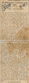 Eltham District Historical Society Inc
Newspaper Clipping, Australian Landscape Art; A fine collection; The Daily Telegraph (Sydney, NSW), p4, November 18, 1918
AUSTRALIAN LANDSCAPE ART. A FINE COLLECTION. The late Mr. Walter Withers was one of the little band of landscapists that Included Streeton Condor, who pioneered the "plein-airiste" movement In Victoria thirty years ago. Mr. Withers had been trained in Paris, but practically all his artistic life was spent in Australia, and examples from his easel are to be found in all the leading Australian galleries. He belonged to a brilliant little coterie of men whose works have since been eagerly sought for at ever-rising prices. And now collectors have an opportunity of acquiring examples of his art for a thoroughly characteristic collection of his work, both in oils and in water-color, will be open to-day In the fine art gallery at Anthony Horderns', in George Street. The collection includes 28 paintings in oil by the late Mr. Walter Withers, and 32 of his water-color drawings, while smaller collections by his daughter, Miss Margery Withers, and by his son, Mr. Meynell Withers, are also added. Among the landscapes in oils by the deceased artist may be seen examples of many moods, and also many phases of his artistic development. At different times he was a realist, a romanticist, an idealist. In his fine picture "The Easter Moon" the emotional appeal to the homing instinct is direct and compelling. This delightful work, low in tone and charming in its feeling of repose, suggests the sentiment of Gray's "Elegy." Entirely different in range, intention, and feeling, are two brilliantly-painted pictures entitled "The Young Gardener," and "The Dividing Fence," Mr. Withers here displays an unusual gift for placing effective notes in an admirably harmonised color scheme. "Sunlight in the Forest" is a pastoral poem in color. Most of these pictures were painted in the Eltham or Warrandyte country, while the "marines" are impressions at Phillip Island or on the shores of the bay. The artist was well equipped with technical knowledge and experience. His pictures are full of air and sunlight, and his realisation of cloud-forms is most convincing. The watercolor drawings which he did in the full maturity of his powers have, a softness, richness, and depth of color quite unusual. His son, Meynell Withers, shows a collection of landscapes of striking merit, recalllng his father's handling of color and selective taste In composition. Miss Margory Withers shows a charming group of watercolor portraits, and also some meritorious landscapes. The pictures have been hung with fine artistic discrimination in the grouping of the subjects, and so skilfully that in each group an essential harmony of tone has been preserved. The exhibition will be open to the public from to-day. AUSTRALIAN LANDSCAPE ART. (1918, November 18). The Daily Telegraph (Sydney, NSW : 1883 - 1930), p. 4. Retrieved August 22, 2023, from http://nla.gov.au/nla.news-article239575164Journal inscribed: "Mrs Withers 463 Collins St. West Melbourne"art exhibition, art review, artist, john withers collection, walter herbert withers -
University of Melbourne, Burnley Campus Archives
Plan, Yates Landscape Details - Mr & Mrs Yates, 1993
Plans by John Patrick Pty. Ltd. (1) Tracing paper plan, Yates Landscape Details DRG No P9235-L3. Drawn by M.P. 12.1.93. (2) Tracing paper plan, Irrigation Plan DRG No P9235-L3. Scale 1:100. Drawn by M.P. 20.8.93. (3) Tracing paper plan, Yates Planting and Layout DRG No 9235-L1. Drawn by M.P. 6.1.93.john patrick pty. ltd., hawthorn, yates, landscape design -
 Victorian Aboriginal Corporation for Languages
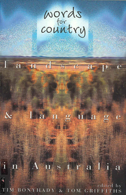
Book, Tim Bonyhady, Words for country : landscape &? language in Australia, 2002
Landscape and Language -- Lubra Creek -- The River Runs Backwards -- These Blarsted Hills -- Scarcely Any Water on Its Surface -- Everyone Who Has Ever Done A Tree Sit Always Says That The Tree Talks To You -- The Spirit of the Plains Kangaroo -- The Graveyard of a Century -- So Much for a Name -- Blackfellow Oven Roads -- The Ends of the Earth -- Natural Beauty, Man-Made -- Uluru -- The Outside Country -- It's Only Words.Mapslanguage and landscape, language essays, writing, storytelling -
University of Melbourne, Burnley Campus Archives
Plan, Roh Cross, Lilydale Quarry Recreational Study for Landscape Studies, 1986
Plans on tracing paper and paper by Rob Cross Landscape Design. (1) Site Analysis No 1 dated 08.06.96. Scale 1:2400. (2.) Proposed Activity Zones No 2 dated 03.06.96. Scale 1:2400. (3) West Section of Valley No 3 dated 11.06.96. Scale 1:1000. (4) Concept Plan No 4 dated 11.06.96. Scale 1:2400. (5) Axonometric View No 5 dated 30.06.96. Scale 1:2400.lilydale, quarry, rob cross landscape design, landscape studies -
 Eltham District Historical Society Inc
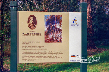
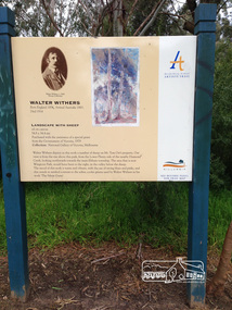
Photograph, Heidelberg Artists Trail sign, "Landscape with Sheep" Walter Withers, Wingrove Park, Eltham, c.May 2001
The Heidelberg School Artists Trail was established in about 1999 with about 52 signs across four local governemnt areas including Nillumbik and Banyule. This one acknowledges "Landscape with Sheep" by Walter Withers. The text on the board states: Walter Withers depicts in this work a number of sheep on Mr. Tom Orr’s property. Our view is from the rise above this park, from the Lower Plenty side of the nearby Diamond Creek, looking northwards towards the main Eltham township. The area that is now Wingrove Park, would have been to the right, in the valley below the sheep. The mood of this work is warm and vibrant, with the use of strong blues and pinks, and this stands in marked contrast to the softer, cooler greens used by Walter Withers in his work ‘The Silent Gums’.Roll of 35mm colour negative film, 7 stripsAgfa HDC 200 plus-2eltham, heidelberg artists' trail, wingrove park trail, landscape with sheep, walter withers -
 Eltham District Historical Society Inc
Audio - Audio Compact Cassette Tape, Shire of Eltham, Audio Recording; Listening to the landscape: stories and places collected from the Shire of Eltham, 1988, 1989
Listening to the landscape is a project in sound, made from recordings and interviews collected in and around the Shire of Eltham over the course of 12 months which were published in 1989. Thirty people, all of whom have lived or worked around the region most of their lives, were interviewed. There are six "channels" of stories: 1. Getting around - 2. "they were the wildflowers - we used to pick armfuls of them in those days" - 3."Up around Kinglake" - 4. "But it was home and no-one could put us out of it" - 5. "It was all orchards" - 6. "gradually the houses came". Each with a slightly different theme. The stories are supported by environmental and historical sound recordings. Tapes converted to three CDs - titled "Getting around" - Armful of flowers" and "Up around Kinglake" which includes the six "channels".Master recordings on three compact cassette audio tapes, TDK AD46. Each tape labeled with the recording track in red ink and Dolby B Noise Reduction activated) also in black ink copyright Duncan King-Smith 1989 Copy 1 Channel 2: Armfuls of Wildflowers Channel 4: “It was home . . .” Copy 2 Channel 1: Getting around Channel 6: “Gradually the houses came . . . ” Copy 3 Channel 3: Up around Kinglake Channel 5: “ . . it was all orchards.” Also commercial compact cassettes and CD formats held and information booklet. Converted to mp3 format from CD 1 - Getting Around; 17:17, 23.7 MB, 192kbs 2 - Gradually the houses came; 17:32, 24.0 MB, 192kbs 3 - Up around Kinglake; 23:31, 32.3 MB, 192kbs 4 - It was all orchards; 23:52, 32.7 MB, 192kbs 5 - Armful of wild flowers; 20:38, 28.3 MB, 192kbs 6 - But it was home, and no-one could put us out of it; 20:58, 28.8 MB, 192kbsaudio cassette, audio recording, duncan king-smith, eltham, listening to the landscape, compact disc, oral history, shire of eltham archives, series 45 -
 Eltham District Historical Society Inc
Photograph, Peter Pidgeon, Landscape with sheep by Walter Withers part of the Heidelberg Artist Trail, 2 Sep 2017
The Heidelberg School Artists Trail was established in about 1999 with about 52 signs across four local governemnt areas including Nillumbik and Banyule. This one acknowledges "Landscape with Sheep" by Walter Withers. The text on the board states: Walter Withers depicts in this work a number of sheep on Mr. Tom Orr’s property. Our view is from the rise above this park, from the Lower Plenty side of the nearby Diamond Creek, looking northwards towards the main Eltham township. The area that is now Wingrove Park, would have been to the right, in the valley below the sheep. The mood of this work is warm and vibrant, with the use of strong blues and pinks, and this stands in marked contrast to the softer, cooler greens used by Walter Withers in his work ‘The Silent Gums’. Heritage Excursion by EDHS members - An Eltham South Ramble, 2 Sep 2017Born Digitalactivities, eltham district historical society, eltham south, heritage excursion, local history centre, eltham, heidelberg artists' trail, walter withers, landscape with sheep, wingrove park trail -
University of Melbourne, Burnley Campus Archives
Document, Report on landscape education in Australia for the Australian Institute of Landscape Architects, 1968
(Not considered likely by Burnley)australian institute of landscape architects, education -
 RMIT Design Archives
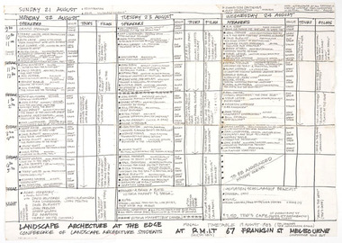
Photocopies, Landscape Architecture at the Edge: Conference of Landscape Architecture Students
Handwritten timetable by Maggie Fooke and Jerry de Gryce. Fooke wrote the headlines and de Gryce the smaller print.ink, paper -
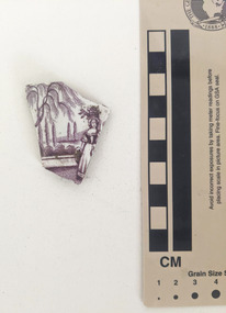 Working Heritage Crown Land Collection
Ceramic - Ceramic shard, Mint ceramic shard
Ceramic shard with white glazed finish and a purple pictorial design of a woman holding a basket on her head within a landscape. purple pictorial design of a woman holding a basket on her head within a landscape. pottery, ceramic, archaeology -
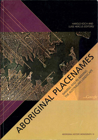 Victorian Aboriginal Corporation for Languages
Book, Harold Koch, Aboriginal placenames : naming and re-naming the Australian landscape, 2009
"Aboriginal approaches to the naming of places across Australia differ radically from the official introduced Anglo-Australian system. However, many of these earlier names have been incorporated into contemporary nomenclature, with considerable reinterpretations of their function and form. Recently, state jurisdictions have encouraged the adoption of a greater number of Indigenous names, sometimes alongside the accepted Anglo-Australian terms, around Sydney Harbour, for example. In some cases, the use of an introduced name, such as Gove, has been contested by local Indigenous people." "The 19 studies brought together in this book present an overview of current issues involving Indigenous placenames across the whole of Australia, drawing on the disciplines of geography, linguistics, history, and anthropology. They include meticulous studies of historical records, and perspectives stemming from contemporary Indigenous communities. The book includes a wealth of documentary information on some 400 specific placenames, including those of Sydney Harbour, the Blue Mountains, Canberra, western Victoria, the Lake Eyre district, the Victoria River District, and southwestern Cape York Peninsula." -- Publisher description. Contents: Introduction: Old and new aspects of Indigenous place-naming /? Harold Koch and Luise Hercus NSW &? ACT: 1. Aboriginal placenames around Port Jackson and Botany Bay, New South Wales, Australia: sources and uncertainties /? Val Attenbrow 2. Reinstating Aboriginal placenames around Port Jackson and Botany Bay /? Jakelin Troy and Michael Walsh 3. The recognition of Aboriginal placenames in New South Wales /? Greg Windsor 4. New insights into Gundungurra place naming /? Jim Smith 5. The methodology of reconstructing Indigenous placenames: Australian Capital Territory and south-eastern New South Wales /? Harold Koch Victoria: 6. Toponymic books and the representation of Indigenous identities /? Laura Kostanski 7. Reviving old Indigenous names for new purposes /? Laura Kostanski and Ian D. Clark 8. Reconstruction of Aboriginal microtoponymy in western and central Victoria: case studies from Tower Hill, the Hopkins River, and Lake Boga /? Ian Clark South Australia &? Central Australia: 'Aboriginal names of places in southern South Australia': placenames in the Norman B.Tindale collection of papers /? Paul Monaghan 10. Why Mulligan is not just another Irish name: Lake Callabonna, South Australia /? J.C. McEntee 11. Murkarra, a landscape nearly forgotten: the Arabana country of the noxious insects, north and northwest of Lake Eyre /? Luise Hercus 12. Some area names in the far north-east of South Australia /? Luise Hercus 13. Placenames of central Australia: European records and recent experience /? Richard Kimber Northern Australia: 14. Naming Bardi places /? Claire Bowern 15. Dog-people: the meaning of a north Kimberley story /? Mark Clendon 16. 'Where the spear sticks up': the variety of locatives in placenames in the Victoria River District, Northern Territory /? Patrick McConvell 17. 'This place already has a name' /? Melanie Wilkinson, Dr R. Marika and Nancy M. Williams 18. Manankurra: what's in a name? placenames and emotional geographies /? John J. Bradley and Amanda Kearney 19. Kurtjar placenames /? Paul Black.Maps, b&w photographs, tables, word listsaustralian placenames, sociolinguistics, linguistics, anthropology, sydney harbour placenames, blue mountains placenames, canberra placenames, western victoria placenames, lake eyre placenames, victoria river district placenames, cape york peninsula placenames -
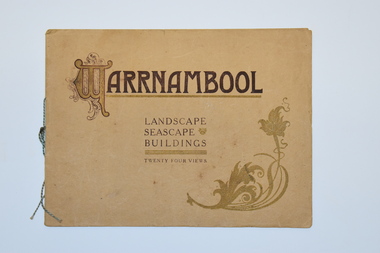 Warrnambool and District Historical Society Inc.
Booklet, Walter Davies, Warrnambool, Warrnambool - Landscape, Seascape, Buildings, early 20th century
This is a souvenir booklet Souvenir Booklet of WarrnamboolThis is a booklet of 16 pages. The cover is buff-coloured and has ornamental patterns and brown printing on the front cover. The pages contain printed text and 24 black and white photographs. Some pages have handwritten annotations.non-fictionThis is a souvenir booklet Souvenir Booklet of Warrnamboolwarrnambool tourism, walter davies bookseller warrnambool -
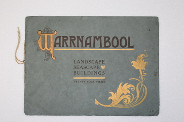 Warrnambool and District Historical Society Inc.
Booklet - Souvenir Booklet, Warrnambool Landscape Seascape Buildings, c. 1920
souvenir booklet of WarrnamboolThis is a booklet with a green cover with black and gold printing and ornamentation. The pages contain 24 black and white photographs and are tied together with string.non-fictionsouvenir booklet of Warrnamboolwarrnambool vintage tourist souvenirs, walter davies -
 Eltham District Historical Society Inc
Slide - Photograph, Landscape, Lavender Park Road, Eltham South, c. 1988
35mm colour positive transparency Mount - Black and Whitelandscape, percy leason, lavender park road -
 Eltham District Historical Society Inc
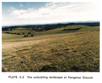
Work on paper (Sub-Item) - Photograph, The undulating landscape at Kangaroo Ground
kangaroo ground -
 Marysville & District Historical Society
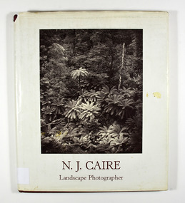
Book - Hardcover book, N.J. Caire Landscape Photographer, 1988
A book of photographs taken by Nicholas John Caire of places and scenery throughout Victoria.A book of photographs taken by Nicholas John Caire of places and scenery throughout Victoria. Photographs by Nicholas John Caire are among the most widely published late nineteenth and early twentieth-century Australian photographs. Between 1875 and 1905 Nicholas Caire travelled the Victorian countryside, looking to capture the scenery for the commercial market. His artistic sensitivity created images which earned him popular acceptance during his lifetime and an enduring place as one of Australia's finest landscape photographers.Hardcover. Front cover photograph-Fairy Scene at the Landslip, Blacks' Spur c1878-9; taken by Nicholas John Caire.For Jane and Clarephotographers, australia, photograpy, landscapes, history, description, travel, views, anne pitkethly, don pitkethly, nicholas john caire, victoria -
 Marysville & District Historical Society
Book, N.J. Caire Landscape Photographer, 1988
A book of photographs taken by Nicholas John Caire of places and scenery throughout Victoria.A book of photographs taken by Nicholas John Caire of places and scenery throughout Victoria. Photographs by Nicholas John Caire are among the most widely published late nineteenth and early twentieth-century Australian photographs. Between 1875 and 1905 Nicholas Caire travelled the Victorian countryside, looking to capture the scenery for the commercial market. His artistic sensitivity created images which earned him popular acceptance during his lifetime and an enduring place as one of Australia's finest landscape photographers.Hardcover. Front cover photograph-Fairy Scene at the Landslip, Blacks' Spur c1878-9; taken by Nicholas John Caire.For Jane and Clarenicholas j caire, photographers, australia, photograpy, landscapes, history, description, travel, views, anne pitkethly, don pitkethly, victoria -
 Federation University Historical Collection
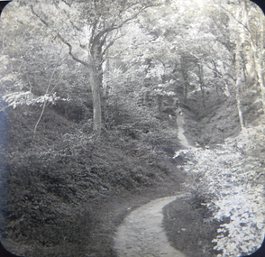
Photograph - Glass Plate, Henry Sutton, Path Through a Landscape by Henry Sutton, c1891
Henry Sutton was born in Ballarat into the musical Sutton Family. He is known as an important Australian inventor. Photograph of two boys paddling in a canal, watched by a number of onlookers.henry sutton, glass plates, photography, landscape, path