Showing 2592 items
matching maps of victoria
-
 Frankston RSL Sub Branch
Map Case
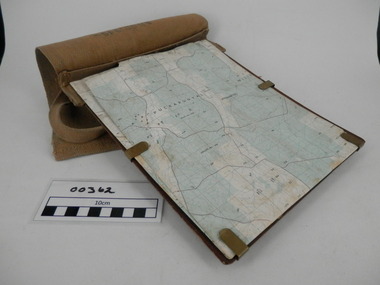
... Survey map of Puckapunyal, Victoria produced in 1988... Survey map of Puckapunyal, Victoria produced in 1988. Inscription ...Standard Australian Army webbing map case with shoulder strap. This map case is complete with a folded Australian Survey map of Puckapunyal, Victoria produced in 1988. Inscription BHG Ltd 1945 -
 Federation University Historical Collection
Photograph - coloured, Department of Lands and Survey, Portion of Victoria showing auriferous areas and mineral localities, 1935, 1935
... Map included with book "Victoria: Gold and Minerals" issued... Fold out coloured map Portion of Victoria showing auriferous ...Map included with book "Victoria: Gold and Minerals" issued by Mines Department Victoria, 1935Fold out coloured mapYellow mark indicating depositsvictoria, auriferous areas, mineral localities, department of mines, tin, antimony, copper, silver lead, tungsten, manganese, platinum, iron -
 Eltham District Historical Society Inc
Document - Folder, Survey Maps and Technical Drawings
... of Victoria, published 1869, Issued 1914 4. Map: Lake Mountain.... Military Survey Map: Ballan, Victoria, No. 837 Zone 7, Sheet South ...alan gardiner collection, maps -
 Bendigo Historical Society Inc.
Map - CAMPBELL COLLECTION: BENDIGO AND DISTRICT MAPS
... Map. Forest Commission Victoria, Bendigo Forest District... Bendigo forest district Map. Forest Commission Victoria, Bendigo ...Map. Forest Commission Victoria, Bendigo Forest District, Basic information prepared 1982, scale 1:100,000. Fire Prevention Strategy Plan. Mitiamo, Greater Bendigo Area, Castlemaine F.D.map, bendigo, forest district -
Glenelg Shire Council Cultural Collection
Map - Fold-out fire control map - Region 4 Victoria, n.d
... Fold-out fire control map - Region 4 Victoria...Fold-out fire control map for Region 4 - Victoria Northern... and alphabetical index. Map Fold-out fire control map - Region 4 Victoria ...Fold-out fire control map for Region 4 - Victoria Northern sheet, includes numerical and alphabetical index. -
University of Melbourne, Burnley Campus Archives
Map (item), Proposed Reserve for Horticultural & Experimental Garden in the Survey Paddock. Clement Hodgkinson Deputy Surveyor General, 1862
... Coloured printout of map in Public Record Office Victoria... Survey Paddock Clement Hodgkinson Coloured printout of map ...horticultural & experimental garden, survey paddock, clement hodgkinson -
Glenelg Shire Council Cultural Collection
Headwear - Town Crier's Hat - Syd Cuffe, n.d
... - gold map of Victoria Australia, Victorian flag, silver buffalo... - gold map of Victoria Australia, Victorian flag, silver buffalo ...Syd Cuffe's Town Crier's hat. Black felt sides, turned up with point in brim at front, back of brim also turned, trimmed in gold fabric black ribbon rosette on front brim, also 4 badges - gold map of Victoria Australia, Victorian flag, silver buffalo (Manitoba) and Canadian flag. Cockatoo feather threaded through gold ribbon on back. two small fabric appliqués on back turned up brim - red maple leafFront: Maker's tag inner crown. Red flower with green stemsyd cuffe, town crier, hat, headwear -
 Bendigo Historical Society Inc.
Slide - DIGGERS & MINING. THE CHINESE ON THE GOLD FIELDS, c1850s
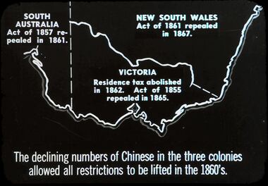
... : Shows map of Victoria and part of South Australia and New South.... The Chinese on the Gold Fields. Slide: Shows map of Victoria and part ...Diggers & Mining. The Chinese on the Gold Fields. Slide: Shows map of Victoria and part of South Australia and New South Wales. South Australia Act. Of 1857 repealed I 1861. New South Wales Act. Of 1861 repealed I 1867. Victoria Residence tax abolished in 1862. Act. Of 1855 repealed in 1865. The declining numbers of Chinese in the three colonies allowed all restrictions to be lifted in the 1860's. Markings: 2 2. Used as a teaching aid.hanimounteducation, tertiary, goldfields -
 Bendigo Historical Society Inc.
Map - STRUGNELL COLLECTION: GEOLOGICAL SURVEY OF VICTORIA, BENDIGO GOLD FIELD - GOLDEN SQUARE, 1992
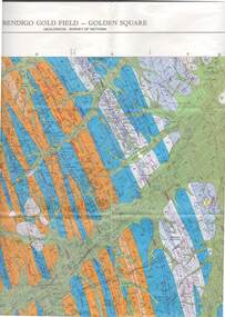
... Map, Geological Survey of Victoria, Bendigo Gold Field... Development. Map, Geological Survey of Victoria, Bendigo Gold Field ...Map, Geological Survey of Victoria, Bendigo Gold Field - Golden Square, Campaspe 10 000/2.2. Victoria 10,000.Dept. 0f Manufacturinf & Industry Development.map, bendigo, golden square gold field -
 Bendigo Historical Society Inc.
Map - STRUGNELL COLLECTION: GEOLOGICAL SURVEY OF VICTORIA, BENDIGO GOLD FIELD - EAGLEHAWK, 1992
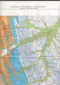
... Map, Geological Survey of Victoria, Bendigo Gold Field... Development Map, Geological Survey of Victoria, Bendigo Gold Field ...Map, Geological Survey of Victoria, Bendigo Gold Field - Eaglehawk.Campaspe10 000/2.3; Victoria 1:10,000. Index of Shafts.Dept. of Manufacturing & Industry Developmentmap, bendigo, eaglehawk gold field -
Bendigo Historical Society Inc.
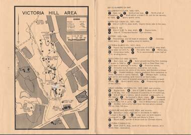
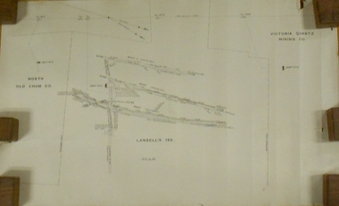
Document - VICTORIA HILL - VICTORIA HILL AREA MAP
... VICTORIA HILL - VICTORIA HILL AREA MAP... Victoria Hill Map...Photocopied map on cream paper. Map is the Victoria Hill... Bendigo victoria hill Victoria Hill Victoria Hill Map Gold Mines ...Photocopied map on cream paper. Map is the Victoria Hill area showing the locations of the Gold Mines Hotel, John Brown Factory and W Rae's Home. Map also shows mine shafts and open cuts.map, bendigo, victoria hill, victoria hill, victoria hill map, gold mines hotel, john brown factory, w rae's home, victoria consols, adventure and advance open cut, great central victoria, rae's open cut, victoria qiartz, ballerstedt's open cut, lansell's '180', north old chum, central nell gwynne -
Federation University Historical Collection
Book, George Brown, Prospectors' Guide (Victoria), 1936, 1936
... Brown soft covered book with pullout map showing auriferous... with pullout map showing auriferous areas of Victoria. Prospectors ...Brown soft covered book with pullout map showing auriferous areas of Victoria. prospecting, gold, geology, quartz reefs, indicators, ballarat indicators, miners' rights, mining leases, forest regulations, equipment, gold cradle, puddling machine, sluice box, whim, whip, california pump, cradle, mining, tools, mining laws -
 Bendigo Historical Society Inc.
Map - VICTORIA HILL AREA
... Map of Victoria Hill Area printed on yellow paper. Details... Claim Victoria Hill Reserve Mines Dept Reervation Map ...Map of Victoria Hill Area printed on yellow paper. Details of tracks, cuttings, contours (in Metres) and Anticline. Location of mines, open cuts and buildings are shown. Numbers on map are: Ballerstedt's Claim 1 - 5; North Old Chum Co. 6; Lansell's 180, 7,8,11; Battery 9.10.12; Victoria Quartz Co. 13 - 17; Rae's Open Cut and Vicinity 18 - 28, Great Central Victoria Co 29 - 36, Adventure and Advance Area and vicinity 37 - 40 and Victoria Consols Co 41.map, bendigo, victoria hill, victoria hill area, victoria consols, new chum anticline, great central victoria, rae's open cut, w rae's home, victoria quartz, ballerstedt's open cut, lansell's 180, north old chum, central nell gwynne, john brown factory, gold mines hotel, cleopatra needle type chimney, floyd's battery, ballerstedt's 24yd claim, humboldt shaft, wittscheibe's jeweller's shop, luffsman and sterry's claim, victoria hill reserve, mines dept reervation -
 Warrnambool and District Historical Society Inc.
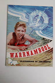
Document - Warrnambool Playground of the South Tourist Guide, Collett & Bain, 1959
... on the sand dunes, a small map of Victoria locating Warrnambool... an illustration of a young man on the sand dunes, a small map of Victoria ...A 1959 tourist guide showcasing Warrnambool attractions.This guide gives an insight into tourist attractions and facilities in Warrnambool in the late 1950'sThis 24page paper booklet contains colour and black and white photographs and text showcasing Warrnambool as a tourist destination. The front cover has an illustration of a young man on the sand dunes, a small map of Victoria locating Warrnambool in the bottom left hand corner and stylised tourist activities in the top right hand quadrant. The rear cover has a photograph of a woman in a swimsuit holding a green surf board surrounded by stylised tourist activities printed in red ink. There is a blue banner across the bottom of the rear cover.Front cover: Warrnambool Playground of the South Rear cover: A Warrnambool Holiday for Everyonewarrnambool, warrnambool tourist guide -
Stawell Historical Society Inc
Book - Somerset, Florence Chuk, The Somerset Years, 1987
... End maps: front Somerset Shire. Back Victoria...End maps: front Somerset Shire. Back Victoria Government ...End maps: front Somerset Shire. Back VictoriaHardback with dust jacket, Beige. Colour print of mining scene, tent, women, men, minesGovernment Assisted Emigrants from Somerset and Bristol who arrived in Port Phillip Victoria 1839 - 1854 Author Florence Chuk. Signed by Author - Florence Chuk 14-11-89 -
 Bendigo Historical Society Inc.
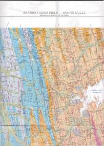
Map - STRUGNELL COLLECTION: GEOLOGICAL SURVEY OF VICTORIA, BENDIGO GOLD FIELD - SPRING GULLY, 1987
... Map, Geological Survey of Victoria, Bendigo Gold Field... & Resources. Map, Geological Survey of Victoria, Bendigo Gold Field ...Map, Geological Survey of Victoria, Bendigo Gold Field - Spring Gully, Campaspe 10 000 2/1; Victoria 10,000.Cept. Of Industry, Technology & Resources.map, bendigo, spring gully gold field -
 Warrnambool and District Historical Society Inc.
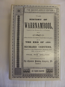
Book, The History of Warrnambool by Richard Osburne, 1980
... the cover is a map of southwest Victoria (1880). There are five fold... the cover is a map of southwest Victoria (1880). There are five fold... paper with black writing. Inside the cover is a map of southwest ...Richard Osburne (1825-1895) came to Warrnambool in 1847, a pioneer resident in the new settlement. In 1851, with John Wilkinson, he founded Warrnambool’s first newspaper, the Warrnambool Examiner, and issued it weekly for some months until he left the town for the goldfields. Returning in 1853 he resumed publication of the Examiner and continued it, intermittently in its last few years, until 1880. He was acknowledged in his day as the Father of the Warrnambool Press and was a dominant figure in Warrnambool’s early history. He was associated with the establishment of the Aboriginal Reserves, Fire Brigade, Mechanics’ Institute, Warrnambool Council, National School, Presbyterian Church, Public Wants Committee, Villiers Building Society, Fish Protection Society, Dramatic Club, Cricket Club, Otway Gold Exploration Syndicate and other institutions. In 1882 he went to live in Melbourne, returning to publish his ‘History of Warrnambool’ in 1887, a Queen’s Jubilee publication. Richard Osburne’s book is a seminal work of the 19th century history of Warrnambool and its importance cannot be over-emphasized. The original copies of this book are now hard to get and are very valuable. This facsimile is kept because the facsimiles are also now becoming rare and they are good examples of the way a facsimile is reproduced and the reason for the existence of this particular reprint– the importance and usefulness of Osburne’s history and the need to make it accessible to researchers today.This is a facsimile edition (1980) of Richard Osburne's book on the history of Warrnambool from 1847 to 1886. It is a hard cover buff-coloured book with gold lettering on the spine. The dust cover is cream-coloured paper with black writing. Inside the cover is a map of southwest Victoria (1880). There are five fold-up inserts (sketches, diagrams etc), a number of business advertisements, sepia photographs and sketches and an index. The dust cover includes information on the author. There are 25 chapters, a foreword by the Prime Minister of Australia, Malcolm Fraser and a Preface The proceeds of the book reprint went to Flagstaff Hill Maritime Village.This is a facsimile edition (1980) of Richard Osburne’s book on the history of Warrnambool from 1847 to 1886. It is a hard cover buff-coloured book with gold lettering on the spine. The dust cover is cream–coloured paper with black writing. Inside the cover is a map of southwest Victoria (1880). There are five fold-up inserts (sketches, diagrams etc), a number of business advertisements, sepia photographs and sketches and an index. The dust cover includes information on the author. There are 25 chapters, a foreword by the Prime Minister of Australia, Malcolm Fraser and a Preface The proceeds of the book reprint went to Flagstaff Hill Maritime Village.richard osburne, the history of warrnambool, warrnambool examiner -
Glen Eira Historical Society
Map - Victorian Railways
... map of Victoria with passenger mileages (in miles) which shows... railways grid map of Victoria with passenger mileages (in miles ...This file contains three items. 1. Original railways grid map of Victoria with passenger mileages (in miles) which shows railway stations in Glen Eira as part of the rail network. 2. Original pamphlet titled ‘Pocket History Vicrail 1839 – 1981’, dated 1981. Chronological history of milestones and dates, ie. 1981 Caulfield loop opened 24/01/1981 as part of underground rail loop. Image on front cover shows 2 images (steam train and stainless steel train). 3. Original pamphlet by Ministry of Transport titled ‘Your neighbourhood Public Transport System’ outlining fare structure. Stylised map of Caulfield (Glen Eira) neighbourhood.carnegie, bentleigh, caulfield, elsternwick, glenhuntly, ormond, murrumbeena, railways, public transport, bus, train, tram, railway stations, ‘vicrail’, underground rail loop -
 Bendigo Historical Society Inc.
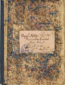
Book - EXERCISE BOOK: KAMAROOKA CENTRAL STATE SCHOOL, 1894
... grammar, arithmetic, geography and hand-drawn maps of Australia... in ink include grammar, arithmetic, geography and hand-drawn maps ...Exercise book belonging to Aggie Miles - Kamarooka Central State School, No. 3182. Contents in neat writing in ink include grammar, arithmetic, geography and hand-drawn maps of Australia, Victoria and Africa. Dated on cover, 1894. See research in Agnes.person, individual, kamarooka state school, kamarooka central state school no. 3182 -
 Warrnambool and District Historical Society Inc.
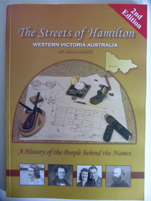
Book, Streets of Hamilton, 2007 (revised and reprinted 2009)
... , an outline of a map of Victoria and a photograph of a map... Hamilton people, an outline of a map of Victoria and a photograph ...This is a book providing information on the streets of Hamilton, Victoria and the origin of the names. Hamilton is a city in Western Victoria at the intersection of the Glenelg Highway and the Henty Highway. European settlement began with the arrival of pastoralists following the 1836 explorations of Major Thomas Mitchell. The Wedge family in 1839 had the property ‘The Grange’ which covered the site of Hamilton today. The town was gazetted in 1851 and named after a place in Scotland. Hamilton Victoria is the centre of a sheep-grazing and agricultural district. The book won an award in the 2008 Victorian Community History Awards. This book is of interest as it gives information on the Hamilton streets and the origin of their names. The history of Hamilton is of particular interest to those also living in the Western District. The book will be a useful research tool. This is a soft cover book of 174 pages. The back cover has a white background with black and white photographs of five local Hamilton people. The front cover has a yellow and brown background with black and white photographs of five local Hamilton people, an outline of a map of Victoria and a photograph of a map of the Hamilton area with some artefacts placed on the map. The book contains an Introduction, a Preface, a Foreword, an Early Days Overview, a list of Contents, a list of the streets in alphabetical order with information on the origin of the names, two Appendices and an Index. The book has many black and white photographs and sketches. Front Cover: ‘2nd Edition’ ‘The Streets of Hamilton’ ‘Western Victoria Australia’ ‘By John McKay’ ‘A History of the People behind the Names’hamilton, victoria, john mckay, street names of hamilton, warrnambool -
 Kiewa Valley Historical Society
Maps - Bogong x2, Tawonga, Omeo, Dargo, Victoria and others, 1. Bogong Alpine Area; 2. Bogong 8324; 3. Tawonga Topographical; 4. Omeo 8433; 5. Dargo 8323; 6. Victoria State
... ' and a light green map of Victoria with 'VICMSP' printed in white. 2... & Mapping Victoria' and a light green map of Victoria with 'VICMSP ...1. Bogong Alpine Area (outdoor Leisure Map. survey & Mapping Victoria, Government of Victoria, Edition 2, reprinted 1991 with an image of Mt. Feathertop on the front. Information for tourist in the Alpine National Park: Bogong Area. Including: recreational activities, history, weather and vegetation and a list of walks together with locality maps and photographs. The front cover has an image of Mt Feathertop against a blue sky with yellow writing 'Bogong Alpine Area', there is a yellow triangular block on the right hand top corner with black writing 'Outdoor Leisure Map. On the bottom edge is a block of yellow with black writing 'Survey & Mapping Victoria' and a light green map of Victoria with 'VICMSP' printed in white. 2. 8324 Bogong Victoria, Edition 1, Commonwealth of Australia 1981. A topographical Map: 1:100,000 scale (1 cm to 1 KM). Map has a red cover with white writing together with a white block and black writing and a map insert. 3. Tawonga Topographical Map - Forests Commission Victoria, / revised 5/9/77, DEG No. 68-G/399. A Tawonga 803 folded map in a beige colour with the back blank. 4. Omeo 8433 Victoria, Edition 1, Department of Natural Resources. The map has a red and white cover with black writing and a simple map of Australia at the bottom. 5. 8323 Dargo, Edition 1, Commonwealth of Australia. A red and white cover with a map insert. 6. Victoria State Map, Hema Maps, 2002. Hema Maps, State Map, colourful cover with a map of Australia and four tourism photographs. Scale 1: 850,000 An inscription handwritten in blue pen "Trappers Gap to Mitta Mitta 1" to 1 mile". There are some pen markings and notations of tracks.maps, bogong, omeo, tawonga, dargo, victoria, bogong alpine area -
 Bendigo Historical Society Inc.
Plan - MARKS COLLECTION: LANSELL'S 180 PLAN, LEVELS 18, 19 AND 20
... 18, 19 and 20. On RH side of map Victoria Quartz Mining... side of map Victoria Quartz Mining company claim marked, on LH ...Plan of underground section of Lansell's 180 mine, levels 18, 19 and 20. On RH side of map Victoria Quartz Mining company claim marked, on LH side North Old Chum Co. 'West or hanging wall' marked above each level.bendigo, mining, lansell's little 180 mine -
Tatura Irrigation & Wartime Camps Museum
Program, Goulburn Weir Rehabilitation Works Opening Ceremony
... of Victoria, map, Goulburn River system... names of Victoria, map, Goulburn River system irrigation ...Includes weir construction history, aboriginal names of Victoria, map, Goulburn River systemProgram of Opening Ceremony. White paper, black writing, blue water wheel logo in plastic sleeveirrigation, document, program, rural, industry -
 Melbourne Tram Museum
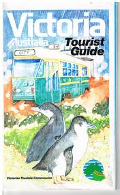
Map, Surveyor General for the Victorian Tourism Commission, "Victoria Australia Tourist Guide", 1985
... Folded map of Victoria, showing in colour relief Victorian... Trams tramways Victoria Map Victour Tourism Folded map ...Folded map of Victoria, showing in colour relief Victorian area, national parks, highways, towns, railways, airport, wine growing areas, towns with information centres, historic parks, ski fields. NSW and SA show major towns and highways. Front cover includes an image of a Z class tram and two penguins. Has town index. Folded 7 folds horizontally by 3 folds deep. On rear is a listing of locations with major tourist destinations provided. Provides location of VicTour offices. Prepared by the Surveyor General for the Victorian Tourism Commission, printed by the Government Printer, 4th edition 1985.trams, tramways, victoria, map, victour, tourism -
Whitehorse Historical Society Inc.
Article, Art in bark, 2012
... of a map of the State of Victoria in eight panels. Col. photo... has displayed their mural of a map of the State of Victoria ...The Art in Bark state branch has displayed their mural of a map of the State of Victoria in eight panels.The Art in Bark state branch has displayed their mural of a map of the State of Victoria in eight panels. Col. photoThe Art in Bark state branch has displayed their mural of a map of the State of Victoria in eight panels. bark murals, art in bark association of australia, koonung cottage community house, gibson, robyn -
 Warrnambool and District Historical Society Inc.
Document, Map: Lady Bay 1853, 1853
... also worked in the vignettes on the Proeschel Map of Victoria.... also worked in the vignettes on the Proeschel Map of Victoria ...This is one of the earliest surveys and maps of Warrnambool harbor, Lady Bay. Being done in 1853, it shows the depths of the bay area marked in fathoms, currents and directions and areas of rocks around mouth of the Merri and the Western side of the bay as well as a large sand spit to the middle right of the beach region.. It also marks the large areas of seaweed and fuci in the outer bay area. It has the area of Pertobe Lagoon marked and shows the early tracks to the town. The engraving work was done by Tulloch and Brown, with Tulloch being one of the earliest engravers and lithographers in the state of Victoria. He arrived in Melbourne in 1849 and set up business with James Davie Brown in 1853 with Brown being a map engraver. They were awarded bronze and silver medals for their work at the Victorian Industrial Exhibition. He also worked in the vignettes on the Proeschel Map of Victoria.This map is of high historical and comparitive significance as it shows the Lady Bay area prior to the changes that have occurred in the last 160 years with the building of the breakwater. The issue regarding access to Lady Bay remains a current one. The engraver D Tulloch engraved some of the earliest scenes of the goldfields in Ballarat and as such has left a record of a very early and important era in Australian history. Rectangular cream paper with black text. Map area is outlined by fine black lined border. Key in top right hand corner and scale at bottom middle of map.Map is labelled Town of Warrnambool printed at top of map. Small logo at top right corner which has “Hydrographic Department” in circle around an anchor. Lady Bay Warrnambool Surveyed by John Barrow assistant surveyor Engraved by Tulloch & Brown in bottom right corner. Melbourne engraved by order of the legislative Council of Victoria in middle bottom.map, warrnambool, town of warrnambool map 1853, tulloch & brown map 1853, lady bay warrnambool,, warrnambool harbour, warrnambool breakwater, warrnambool beach -
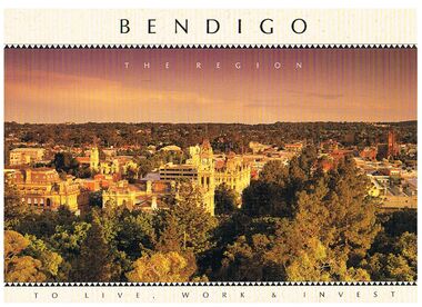 Bendigo Historical Society Inc.
Book - BENDIGO - THE REGION TO LIVE, WORK & INVEST
... Map of Victoria... picture, they are:- Hargreaves Mall, Eaglehawk Golf Course, Map... Golf Course Map of Victoria La Trobe University Big Hill ...Pale yellow 12 page book titled 'Bendigo the Region to Live Work & Invest'. On the front cover is a scenic view of Bendigo and on the back cover a picture of some quartz and gold nuggets on a green background. Sections in the book are: Live Work & Invest, Lifestyle, Access, Community, Infrastructure, Labour Force, Business, Opportunity, Successes and Information. Each page has a colour picture, they are:- Hargreaves Mall, Eaglehawk Golf Course, Map of Victoria, La Trobe University, Big Hill, Regional Office Department of Planning & Development, Sandhurst Farms, Construction Activity, Products of the Region, Dr. Ian Macbean, Mr Evan Jones and the Capital Theatre with information on each.book, bendigo, bendigo, bendigo - the region to live, work & invest, bendigo regional development board, dr ian macbean, mr evan jones, kate mildren, richard gibbs, express printers, hargreaves mall, eaglehawk golf course, map of victoria, la trobe university, big hill, regional office department of planning & development, sandhurst farms, construction activity, products of the region, capital theatre -
Tatura Irrigation & Wartime Camps Museum
Book, Edward M. Curr. The Tide of History
... . Recollections of squatting in Victoria. Map of Angerang Territory..... Helliers. Recollections of squatting in Victoria. Map of Angerang ...Map of the runs of the late E. M. Curr, St. Helliers. Recollections of squatting in Victoria. Map of Angerang Territory.Front cover profile in red of E. M. Curr. Cover images. Signed by Samuel Furphy, authoredward m curr, st helliers, angerang territory -
University of Melbourne, Burnley Campus Archives
Map - Topographic Survey, Grampians, 1969
... Australia 1:100,000 Topographic Survey Map of the Grampians... Australia 1:100,000 Topographic Survey Map of the Grampians ...Australia 1:100,000 Topographic Survey Map of the Grampians, Victoria dated 1969. Sheet 7323 (Edition 1) Series R 652. Produced by the Royal Australian Survey Corps.grampians, royal australian survey corps, topographic survey -
 Warrnambool and District Historical Society Inc.
Booklet, Victorian Almanacs, 1860s
... also has a map of Victoria as an insert. Both almanacs contain... of it. The 1869 Almanac also has a map of Victoria as an insert. Both ...These Victorian Almanacs were published from 1859 to 1916. They contained information of interest to all Victorians, especially historians, businessmen, farmers and gardeners and must have sold many copies in Warrnambool, particularly before the local Warrnambool Standard Almanacs began publication in 1875. These booklets are of interest as examples of 19th century almanacs published in Victoria. They are also somewhat similar to the Almanacs published annually by the Warrnambool Standard newspaper from 1875 to 1930. The 1869 Almanac is of particular interest as it has on the front cover the printed name of James Hider, stationer and bookseller of Warrnambool. James Hider had been a carpenter, a land agent and a rate collector before opening a shop in Timor Street, selling books and stationery and operating a Circulating Library. In 1865 Hider set up as a photographer and was still operating this business in 1878. He was active in community organizations, including the Mechanics Institute, the Fire Brigade, the National School, the Musical Group and the Benevolent Society. He was also a Councillor and a Mayor in the 1860s. It is interesting to note that his name does not appear to have been been added to the 1869 Almanac cover but is part of the original printing. These are two soft cover booklets of 60 pages each. The back covers of both are missing and the 1868 booklet has some back pages missing. The 1868 Almanac has a black and white cover with ornamental scrolls and the 1869 booklet has a red, green black and cream cover with an ornamental border and images of flora and fauna. The 1869 Almanac cover has a Coat of Arms with Advance Australia printed at the bottom of it. The 1869 Almanac also has a map of Victoria as an insert. Both almanacs contain an historical calendar, Victorian Parliamentary information, data on Victorian cities, postal regulations, farmers’ and gardeners’ guides etc. Both contain advertisements relevant to Melbourne. Both have been bound with string. victorian almanacs, annual journals, james hider, bookseller and stationer,, warrnambool.