Showing 186 items matching "moorabbin station"
-
 Kingston Arts
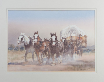
Painting, Gaye Bonham, Horsedrawn Woolwagon
... , 100 metres from Moorabbin train station) Moorabbin melbourne ... -
 Kingston Arts
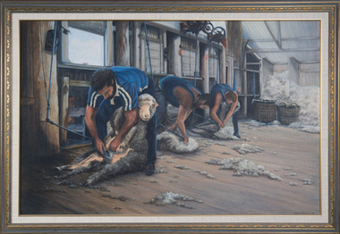
Painting, Dorothy Turnbull, Shearing at Wallanthedy Station, 1988
... , 100 metres from Moorabbin train station) Moorabbin melbourne ... -
 Kingston Arts
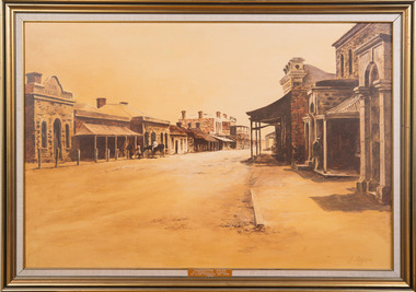
Painting, Julie Ogier, Clare 1870
... , 100 metres from Moorabbin train station) Moorabbin melbourne ... -
 Kingston Arts
Painting, Wendy Smith, Pink Roses
... , 100 metres from Moorabbin train station) Moorabbin melbourne ... -
 Moorabbin Air Museum
Document (Item) - Air Philippines Aircraft Specifications and Documentations RP-C8006 Certificates of Airworthiness. Certificates of Registration. Aircraft Station Licence. Insurance. Weight and Balance. Aircraft Specification. Compass Swing. Other random documents, Air Philippines Random Documentation
-
Moorabbin Air Museum
Manual (Item) - Interference to aeronautical radio systems from television receivers and transmitting stations. Paper 155-57/DO-81, RTCA Radio Technical Commission for Aeronautics
-
Moorabbin Air Museum
Memorabilia (Item) - Presentation Box of 5 soap tablets Fontaine To RAF Officers Station Castle Bromwich by Toro Soap Co Ltd, Presentation Soaps in box
The Officers RAF Kirkham -
Moorabbin Air Museum
Drawing (Item) - P3 Orion Drawing of Flight and Wing Stations
-
Moorabbin Air Museum
Drawing (Item) - Wessex Drawing , Identification Letters-Parent Ship Or Air Station. Drawing No. AMR/WESSEX 29-1
-
Moorabbin Air Museum
Drawing (Item) - Drawing Grumman Tracker , Identification Letters - Parent Ship Or Air Station. Drawing No. AMR/TRACKER /12/1
-
Moorabbin Air Museum
Drawing (Item) - Canberra Stations Diagram Mk 20 A12022 Shts 1, 2 and 3
... Moorabbin melbourne Drawing Canberra Stations Diagram Mk 20 A12022 ... -
Moorabbin Air Museum
Drawing (Item) - DHC Beaver A95 Stations and Centre of Gravity Diagrams A12968 and Issue A12968 (Issue 2)
-
Moorabbin Air Museum
Drawing (Item) - Boston IIIA A28 , Drawing Stations Diagram A5128
-
Moorabbin Air Museum
Drawing (Item) - RAAF Station Diagram for Jindivik Mk II
... Moorabbin melbourne RAAF Station Diagram for Jindivik Mk II Drawing ... -
Moorabbin Air Museum
Manual (Item) - AP 2173A Vol 11 Air Cooled Petrol Engines for Ground Equipment Part 4 Station Workshop Repair
-
Moorabbin Air Museum
Document (Item) - Engineering station drawings and data RAAF
... Moorabbin melbourne Engineering station drawings and data RAAF ... -
Moorabbin Air Museum
Drawing (Item) - F-18 Crew Station Production Configuration
-
Moorabbin Air Museum
Drawing (Item) - F-18 Crew Station Production Configuration
-
 Bayside Gallery - Bayside City Council Art & Heritage Collection
Map, Department of Crown Lands and Survey et al, Moorabbin, County of Bourke, Government Roads, 1920
The cadastral map of the Parish of Moorabbin in Victoria (L.6104) shows parish boundaries and land ownership 1920 when Sandringham was a Town. The government roads have been coloured in red pencil.moorabbin, county of bourke, map, plan, land subdivision, land titles, foreshores, hampton, beaumaris, highett, cheltenham, department of lands and survey, land owners, cartographic material, brighton, sandringham, town of sandringham, government roads -
 Bayside Gallery - Bayside City Council Art & Heritage Collection
Map, Department of Crown Lands and Survey, Moorabbin, County of Bourke, c. 1918
The cadastral map of the Parish of Moorabbin in Victoria (L.6104) shows parish boundaries and land ownership c. 1918 when Sandringham was a Borough.moorabbin, county of bourke, map, plan, land subdivision, land titles, foreshores, sndringham, hampton, beaumaris, highett, cheltenham, department of lands and survey, land owners, cartographic material, borough of sandringham, brighton -
Moorabbin Air Museum
Machine - Link Trainer A13-89, 1942
Historical Details: Serial number DA-389 trainer number D-2-3608, part of the contract DA W535 AC-147, shipped to New York 8-8-1942. Received 1SD 23-11-1942, 7SFTS 1-1-1943, 1SD 27-6-1946, RAAF Station Pt. Cook 9-2-1949.. Description: While it was not the first flight simulator the Link Trainer is, arguably, the most famous. Designed in America by Edward Link in 1936, it was originally intended as a childrens ride for amusement parlours before being adapted as a flight simulator. At. Level of Importance: Regional -
 Kew Historical Society Inc
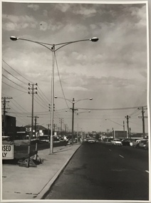
Photograph, Stuart Tompkins Studio, Electricity Supply Poles, South Road, Moorabbin, 1965
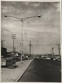
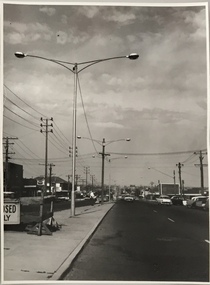
Research provided by Stuart Tompkins Studio, Box Hill, into alternatives for median strip street lighting to be used in Burke Road, Kew. The photographers identified variants in different suburbs appropriate to Kew's needs.The series from which the photograph is drawn provides a snapshot by a commercial photographic studio of each named vicinity in 1965 as well as providing examples of public works infrastructure being commissioned by local government in the 1960s. The photos originally formed part of the Engineering Department's files in the City of Kew before being donated to the kew Historical Society.Electricity Supply Poles, South Road, Moorabbin, 1965. Stuart Tompkins Studio provided this photograph for the Kew City Council. The photograph of South Road, Moorabbin, west of Jasper Road, looking east depicts steel poles with two lamps in a median strip and supply wires from pole to pole. The poles were described as 100′ apart. The notation on the rear of the photograph was that there were lamps along the median strip except at intersections. A wooden pole is recognised as supporting heavy supply lines across the road. The steel poles in the photograph were said to be between 3′ to 3.5′ whereas the wooden poles were three to 12.25″ in diameter. [There are three copies of this photograph in the Collection.] Typed inscription on reverse: "Electricity Supply Poles. Photographed for Kew City Council 8/2/65. No.2 South Road - Moorabbin, west of Jasper Road, looking east. Steel poles with two lamps in median strip and supply wires from pole to pole along median strip (poles only 100' apart). Lamps along median only except at intersections. Wooden pole supports heavy supply lines across the road. Wooden poles 3' up and 8 1/2" dia. Wooden poles 3' up and 12 1/2 dia." Studio stamp: "Stuart Tompkins Studio. 547 Station Street, Box Hill. WX1439."public infrastructure -- kew (vic.), city of kew - engineers department -
 Kew Historical Society Inc
Photograph, Stuart Tompkins Studio, Electricity Supply Poles, South Road, Moorabbin, 1965
Research provided by Stuart Tompkins Studio, Box Hill, into alternatives for median strip street lighting to be used in Burke Road, Kew. The photographers identified variants in different suburbs appropriate to Kew's needs.The series from which the photograph is drawn provides a snapshot by a commercial photographic studio of each named vicinity in 1965 as well as providing examples of public works infrastructure being commissioned by local government in the 1960s. The photos originally formed part of the Engineering Department's files in the City of Kew before being donated to the kew Historical Society.Electricity Supply Poles, South Road, Moorabbin, 1965. Stuart Tompkins Studio provided this photograph for the Kew City Council. The photograph of South Road, Moorabbin, west of Jasper Road, looking east depicts steel poles with two lamps in a median strip and supply wires from pole to pole. The poles were described as 100′ apart. The notation on the rear of the photograph was that there were lamps along the median strip except at intersections. A wooden pole is recognised as supporting heavy supply lines across the road. The steel poles in the photograph were said to be between 3′ to 3.5′ whereas the wooden poles were three to 12.25″ in diameter. [There are three copies of this photograph in the Collection.] Typed inscription on reverse: "Electricity Supply Poles. Photographed for Kew City Council 8/2/65. No.2 South Road - Moorabbin, west of Jasper Road, looking east. Steel poles with two lamps in median strip and supply wires from pole to pole along median strip (poles only 100' apart). Lamps along median only except at intersections. Wooden pole supports heavy supply lines across the road. Wooden poles 3' up and 8 1/2" dia. Wooden poles 3' up and 12 1/2 dia." Studio stamp: "Stuart Tompkins Studio. 547 Station Street, Box Hill. WX1439."city of kew -- engineers department, public infrastructure -- kew (vic.) -
 Kew Historical Society Inc
Photograph, Stuart Tompkins Studio, Electricity Supply Poles, South Road, Moorabbin, 1965
Research provided by Stuart Tompkins Studio, Box Hill, into alternatives for median strip street lighting to be used in Burke Road, Kew. The photographers identified variants in different suburbs appropriate to Kew's needs.The series from which the photograph is drawn provides a snapshot by a commercial photographic studio of each named vicinity in 1965 as well as providing examples of public works infrastructure being commissioned by local government in the 1960s. The photos originally formed part of the Engineering Department's files in the City of Kew before being donated to the kew Historical Society.Electricity Supply Poles, South Road, Moorabbin, 1965. Stuart Tompkins Studio provided this photograph for the Kew City Council. The photograph of South Road, Moorabbin, west of Jasper Road, looking east depicts steel poles with two lamps in a median strip and supply wires from pole to pole. The poles were described as 100′ apart. The notation on the rear of the photograph was that there were lamps along the median strip except at intersections. A wooden pole is recognised as supporting heavy supply lines across the road. The steel poles in the photograph were said to be between 3′ to 3.5′ whereas the wooden poles were three to 12.25″ in diameter. [There are three copies of this photograph in the Collection.] Typed inscription on reverse: "Electricity Supply Poles. Photographed for Kew City Council 8/2/65. No.2 South Road - Moorabbin, west of Jasper Road, looking east. Steel poles with two lamps in median strip and supply wires from pole to pole along median strip (poles only 100' apart). Lamps along median only except at intersections. Wooden pole supports heavy supply lines across the road. Wooden poles 3' up and 8 1/2" dia. Wooden poles 3' up and 12 1/2 dia." Studio stamp: "Stuart Tompkins Studio. 547 Station Street, Box Hill. WX1439."stuart tompkins studio, street lighting, south road (moorabin) 1965, public infrastructure -- city of kew, city of kew -- engineer's department -
Glen Eira City Council History and Heritage Collection
Document (Item) - Newspaper (digital), Caulfield Contact
The Caulfield Contact was the official newspaper of the City of Caulfield from 1976-1994. The City of Caulfield was the Municipal Council for an area of the South Eastern suburbs of Melbourne, including Brighton East, Carnegie, Caulfield, Elsternwick, Gardenvale, Glen Huntly, McKinnon, Murrumbeena, Ormond and St Kilda East. Following Amalgamation of City of Caulfield and parts of the City of Moorabbin in 1994, the Caulfield Contact was followed by the Glen Eira News. Contains References to the following Freedom of Entry to 3rd ordinance of the RAAOC, visit by Sir Zelman Cowen, Return to Rosstown, A 'spacy new home' (nursery at Caulfield Park), Profile on Gus Theobold, Meals on Wheels Aviary completed Caulfield Park. Profile resident Gus Theobold. Cr Irene Capek win Herald Australia Day essay prize. Caulfields Meals on Wheels set Victorian record. Historical feature Return to Rosstown. New ambulance station Glenhuntly and Clarinda roads opens. Volume 4 Number 5 Date 03 August 1978 Features Where and How to Vote in council election. Cr Irene Capek retires from council. Profiles election candidates. Image: Image Cr Irene Capek. Images of election candidates. Volume 5 Number 1 Date 14 September 1978 Freedom of Entry to 3rd ordinance of the RAAOC, visit by Sir Zelman Cowen, Subjects from Carol: GG Sir Zelman Cowen and Lady Cowen offical visit. Off street carpark project underway Pyne St and Hawthorn Rd. City Manager Graeme Caldwell submits plans for Townhall renovations. Action plan for development of Elsternwich Shopping precint to be developed. Freedom of Entry ceremony. Profile Rosemary Keppel. Booran Motors Glenhuntly donate dual control Holden Gemini to Caulfield Tech school pre-driver education program. council election results. Comments from elected Crs Jack Campell, Bob Baxter, Dorothy Ford, Brian Rudzki. Promotion of Caulfield Institute of Technology and TAFE. Image: Image Sir Zelman Cowen, Lady Cowen. Images Freedom of Entry ceremony and citizens attending. Image Rosemary Keppel. Cartoon pre-driver education program. Image Mayor Cr Geoff Patience in robes. Volume 5 Number 2 Date 26 October 1978 Rate rise 5.73% announced. Readership of Caulfield Contact surveyed. Caulfield ranger Reg Dixon and members of works dept rescue duck family from drain and reinstate them to Caulfield Racecourse dam. Profile resident and teacher Claire Manning. Image: Image of Reg Dixon and the rescued ducks. Image Claire Manning and students at Waverley Private school. city of caulfield, caulfield, glen eira, city of glen eira, caulfield contact, freedom of entry to 3rd ordinance of the raaoc, visit by sir zelman cowen, return to rosstown, a 'spacy new home' (nursery at caulfield park), profile on gus theobold, meals on wheels -
 City of Kingston
Photograph - Black and white, c. 1930
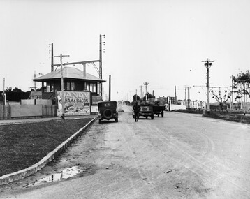
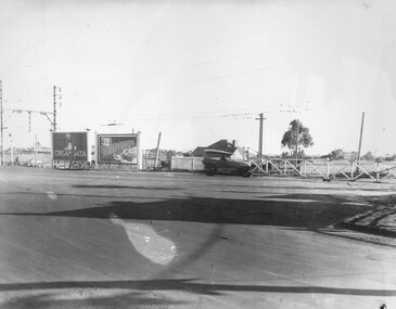
This image is part of a larger collection of images from the Public Transport Corporation displaying train stations and streetscapes in what is now the City of Kingston.The Nepean Highway is a major highway running through the City of Kingston. This image is one of many that depicts its importance to the local community as it undergoes many changes over time.Black and white photograph depicting the level crossing at Moorabbin. While the gates at the level crossing are open, two cars are making their way across the crossing, while a third car is parked on the side of the road, in front of a large billboard/hoarding for ham and bacon products. There is a man standing on the road as if watching the cars go through the crossing. The road appears to be unsealed. Black printed text on a round white sticker adhered to the reverse: 148 Handwritten in red ink: 60% Blue ink stamped on reverse: COPYRIGHT / Public Transport Corporation / For re-ordering photographs / Please quote negative No ADU907 / Enquiries C/- PTC Photographic Unit / Telephone switchboard 619 111moorabbin, trains, railway crossing, level crossing, cars, roads, nepean highway -
 City of Kingston
Photograph - Black and white, c. 1930
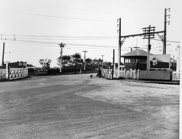
This image is part of a larger collection of images from the Public Transport Corporation displaying train stations and streetscapes in what is now the City of Kingston.The Nepean Highway is a major highway running through the City of Kingston. This image is one of many that depicts its importance to the local community as it undergoes many changes over time.Black and white photograph depicting railway crossing at Nepean Highway Moorabbin. The level crossing gates are open and a man is walking through with his dog. To the right of the crossing is a billboard/hoarding promoting what appears to be a brand of radio/wireless.White round sticker with indecipherable black printed text which has been scribbled over with black pen. White round sticker with black printed text: 175 Handwritten in red ink: 50% Blue ink stamped on reverse: COPYRIGHT / Public Transport Corporation / For re-ordering photographs / Please quote negative No ADV 903 / Enquiries C/- PTC Photographic Unit / Telephone switchboard 619 111moorabbin, trains, railway crossing, level crossing, nepean highway -
 City of Kingston
Photograph - Black and white, c. 1930
This image is part of a larger collection of images from the Public Transport Corporation displaying train stations and streetscapes in what is now the City of Kingston.The Nepean Highway is a major highway running through the City of Kingston. This image is one of many that depicts its importance to the local community as it undergoes many changes over time.Black and white photograph of the level crossing at Neapean Highway Moorabbin. Photograph is a slightly side view, with a blurred image of a car approaching the level crossing. The gates are closed. To the left of the image is a pair of billboards. The billboard on the left is promoting Creamoata, a New Zealand brand of oats, and the billboard on the right is promoting Kraft cheese.White round sticker on reverse with black printed text: 147 Handwritten in red ink on reverse: 100% Blue ink stamped on reverse: COPYRIGHT / Public Transport Corporation / For re-ordering photographs / Please quote negative No ADV 1030 / Enquiries C/- PTC Photographic Unit / Telephone switchboard 619 111moorabbin, level crossing, railway crossing, cars, advertising, nepean highway -
 City of Kingston
Photograph - Black and white, Percy Fairlam, c. 1920
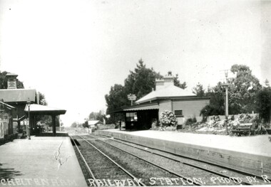
Cheltenham station was built in 1898 and serviced a primarily rural, market gardening community.The late 1870s saw the beginning of a massive program to construct railway lines throughout Victoria. One of these lines was from Caulfield to Frankston. A survey undertaken by J P Madden, an engineer employed by the railways, established the route, although this was later modified. At the time of the official opening of the line to Mordialloc no station buildings had been constructed despite the fact that tenders had been called in the Government Gazette of 26 May 1881 and subsequently in the Argus newspaper on 30 August 1881 for what became stations at Glenhuntly, Ormond, Bentleigh, Moorabbin, Highett, Cheltenham, Mentone and Mordialloc. However platforms and sidings were completed, ready to receive passengers. Cheltenham station opened in 1898.Black and white photograph of Cheltenham Railway Station with the two platforms separated by two sets of tracks. Each platform has a station house on it, and the one on the right hand side also has a garden and park bench.Handwritten in red ink on reverse: A7 / 75%cheltenham, trains, railway, railway station, railway crossing, suburbs -
 City of Kingston
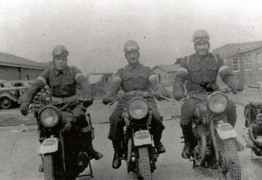
Photograph - Black and white, c.1942
... wireless receiving station established in Chesterville Road... in Chesterville Road, Moorabbin. The station was established ...This image shows motorbike despatch riders who were tasked with transporting intercepted Japanese communications from the wartime wireless receiving station established in Chesterville Road, Moorabbin to Queens Road, St Kilda where the Directorate of Naval Communications and the code-breaking unit called FRUMEL (Fleet Radio Unit - Melbourne) were housed. The despatch riders would travel every two hours, all day and night. The wireless receiving station was established in Moorabbin because it was considered an area free of significant electrical interference and was not too far afield from the Melbourne headquarters in Queens Road. Moorabbin was originally established as a rural market gardening community.A secret wartime wireless receiving station was established in March 1942 in Chesterville Road, Moorabbin. The station was established on requisitioned market garden properties, and soon housed WRAN (Women's Royal Australian Navy) personnel and up to 35 US Navy servicemen. The Navy personnel intercepted Japanese coded communications and then despatched these by motorbike riders to Queens Road, St Kilda where the Directorate of Naval Communications and the code-breaking unit called FRUMEL (Fleet Radio Unit - Melbourne) were housed. The information intercepted by the wireless receiving station helped shape the Allied response to Japan's advances in the Pacific. Declassified defence records show that this unprepossessing station handled some of World War II's most sensitive secrets, and the despatch riders were a familiar sight in the Moorabbin area, though few were aware of their purpose. Black and white image of three men in uniform sitting astride three motorcycles in front of cars and buildings. The rider on the right is Jack Barker a local resident. Handwritten in red ink: A 602 / 90% Handwritten in blue ink: SW / 950301111 Handwritten in grey pencil: A 34 CHAP 6 / Spy basemoorabbin, despatch riders, wireless receiving station, world war ii, frumel (fleet radio unit - melbourne)