Showing 167 items matching "nepean highway"
-
 City of Kingston
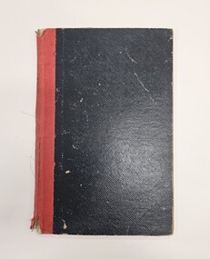
Book - Minute book, Minute book, Cheltenham Community Hospital, 1938
... on the Nepean Highway in Parkdale. The hospital opened in 1953... Ave on the Nepean Highway in Parkdale. The hospital opened ...The Mordialloc-Cheltenham Community Hospital was a hospital in the suburb of Parkdale. Residents of Mordialloc and Chelsea worked towards a community hospital from the late 1930s. Having a community hospital meant residents who required routine surgery did not need to travel into Melbourne to the larger established hospitals. This was important at a time when few people had their own transport. For many years the Mordialloc Carnival Committee contributed to the cost of building the hospital, with one of its contributions to the ‘opening day’ appeal amounting to one thousand pounds, adding to the several thousand already committed. Construction work commenced on the Mordialloc-Cheltenham Community Hospital in 1950. on a site between Booth St and Carrier Ave on the Nepean Highway in Parkdale. The hospital opened in 1953 and serviced the community until 1996. On 1 August 1995, the hospital became a part of the Southern Health Care Network. The former hospital site is now the main location of Central Bayside Community Health Services.Black hard cover book with red spine. cheltenham, mordialloc, hospital, parkdale, health -
 Warrnambool RSL Sub Branch
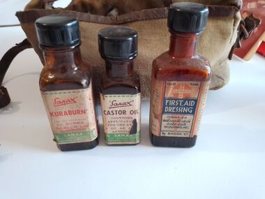
Equipment - WW2 First Aid Kit. Contents, part of, First Aid Dressing
... contains 60% ether. The Sanax Co 349-51 Nepean Highway Moorabin...-51 Nepean Highway Moorabin , Vic 6 sided brown glass bottle ...6 sided brown glass bottle with paper label and black screw capLabel Front: Trade Mark SANAX. FIRST AID DRESSING. Forms an Antiseptic skin over cuts, wounds etc. Label Side: DIRECTIONS. A few drops on the part affected and spread over the injury with the cork. For knuckle joint wounds place on the wound a thin film of absorbent cotton and then pour dressing over freely. Label Side: This bottle must be kept ell corked and away from flames. CAUTION contains 60% ether. The Sanax Co 349-51 Nepean Highway Moorabin , Vic -
 Brighton Historical Society
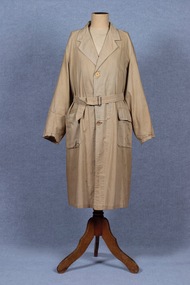
Coat, Dustcoat, c.1948
... on what had been renamed Nepean Highway. The business was sold... and the Commercial Bank on what had been renamed Nepean Highway ...Dust coat worn by Mr Frederick Alister Jennings when he managed a family grocery store circa 1948 at 510 Point Nepean Road, East Brighton. Frederick was born at Nagambie, Victoria in 1909 and died in Brighton in 1979. He was the son of Hugh Edwin Jennings and Alice Constance Warren. He married Margaret Jean Hughes in 1934 and served in the Second World War. He lived at 1 Valda Grove Brighton. Frederick was a commercial traveller as well as his time spent managing the store in Point Nepean Road. It is believed this coat dates from his time at the store c1948 - 1955. The store was owned for many years by his father-in-law W. G. Hughes and was one of a group of shops near the corner of Centre Road. In 1944-45 the group of shops included Fletcher’s fuel merchants, a haberdasher, butcher, fruiterer, grocer, Brighton East post office, a ladies’ hairdresser and Hughes’ grocer. In 1950 Hughes’ grocery store was between a service station and the Commercial Bank on what had been renamed Nepean Highway. The business was sold to G. S. Maynard, grocer, sometime before 1960.Unlined dustcoat of beige cotton. Fastens centre front with three brown plastic buttons. Two large patch pockets. Separate cloth belt with metal buckle. Signs of wear and mending. .1 - coat .2 -beltGarment label reads: APEX (RLG.) Dust Coat DEPT. MYER STORE for MEN. MELBOURNE & ADELAIDEdustcoat, occupational dress, grocer, hughes grocery store, brighton, frederick alister jennings -
 City of Moorabbin Historical Society (Operating the Box Cottage Museum)
Print - Mary Ann Charman 1820 - 1870
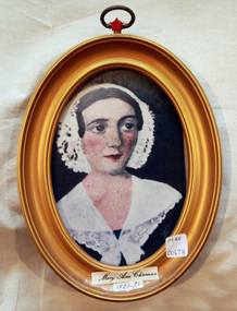
... from Nepean Highway , Cheltenham through Beaumaris... from Nepean Highway , Cheltenham through Beaumaris to the Beach ...Mary Ann Charman was a pioneer settler in the Cheltenham area of the Parish of Moorabbin c1850 Stephen Charman , who emigrated in 1942 as a Henry Dendy employee aged 21 years, sadly lost his wife and child shortly after arriving in Brighton. When Dendy could not employ him he found other work. In 1850 he met Mary Gettens a widow with 5 children who supported her family by managing her late husband’s Inn in Collins St. Melbourne. Stephen purchased land in Spring Grove, now Cheltenham, in 1852 and the family moved to the wattle and daub hut after their marriage. Mary and Stephen worked very hard to establish a market garden, poultry and pork farm . They specialised in Marigolds which they sold to Martin & Pleasance Pharmacy , Melbourne for medicinal purposes. Mary and Stephen had 7 more children and Mary still managed to find time to sell the pork, poultry and vegetables from a horse drawn cart she drove around St Kilda. 1857 Stephen donated land to the Methodist Church for a School, burial ground and Chapel in Balcombe Road. Mary died 1870. Stephen remarried in 1878 and died aged 85 years 1906. Charman Road runs from Nepean Highway , Cheltenham through Beaumaris to the Beach Road at Mentone. Mr Les Jones was the Great Grandson of Mary Ann CharmanAn oval framed colour copy of a painting of the likeness of Mary Ann Charman, 1820 - 1870 pioneer settler in the Cheltenham area of the Parish of Moorabbinpioneers, early settlers, dendy henry, charman mary ann, jones les, cheltenham, moorabbin, brighton, market gardeners, dairy farmers, charman road -
 City of Moorabbin Historical Society (Operating the Box Cottage Museum)
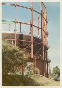
Photographs, x3 Colour,, Highett Gasworks c1974, 1974
... on a complete gas-making unit and the Highett Gasworks, Nepean Highway... and the Highett Gasworks, Nepean Highway, began supply 1939. 1950 ...3 of 5 photographs of the Highett Gasworks c 1974 The Brighton Gas Company was established 1877 by local residents including Thomas Bent. Initially all went well for residents as gas light replaced kerosene lamps and street lights were installed. However disruption to supply, poor quality and failure to reach all house lead to dissatisfaction. Thomas Bent therefore began the Central Brighton and Moorabbin Gas Company 1885 and a price war ensued. This was unsustainable and the two companies amalgamated in 1877 supplying gas from the New Street Works site. 1930 this Company expanded to Highett where it had purchased 45 acres adjacent to the train line. 1927 a gas holder was built connected to the Brighton works 1936 construction began on a complete gas-making unit and the Highett Gasworks, Nepean Highway, began supply 1939. 1950 an extension program was completed. However by 1965 , with the discovery of Natural Gas offshore in Bass Strait, changes to Gas distribution were apparent. At first some of the facilities at Highett were used to distribute the gas piped from Sale, Gippsland. However after conversion of 450,000 homes to Natural Gas the Highett site was redundant. The gasometers were removed 1978. Moorabbin Council obtained part of the land for public recreation purposes. ( Dr. G Whitehead KCC Historian ) c2012 the Moorabbin Justice Centre / Magistrates Court of Victoria was built and further development of the area for apartments proceeds. The establishment of the Brighton Gas Company 1877 and the Highett Gasworks 1885 brought bright lighting to houses, businesses and streets in Moorabbin Shire and cooking ovens and heating improved the living conditions of residents. 3 x Colour photographs of the Highett Gasworks c1970bass strait gas, highett gasworks, brighton gasworks 1877, central brighton and moorabbin gas company 1885, whitehead dr. graham, magistrates court of victoria, horse drawn carts, toll gates brighton, motor cars 1900, steam engines, early settlers, bentleigh, parish of moorabbin, city of moorabbin, county of bourke, moorabbin roads board, shire of moorabbin, henry dendy's special survey 1841, were j.b.; bent thomas, o'shannassy john, king richard, charman stephen, highett william, ormond francis, maynard dennis, market gardeners, vineyards, orchards -
 City of Moorabbin Historical Society (Operating the Box Cottage Museum)
Photographs,x3 Colour Early Weatherboard Cottage Cheltenham c1880, 1981
... Road - Arthur's Seat Rd, later Point Nepean Rd, now Nepean..., later Point Nepean Rd, now Nepean Highway. Notable settlers who ...Henry Dendy , a farmer from Sussex England, purchased 5,120 acres of land in the area of a 'Special Survey 1841' that extended from Brighton bayside North Road, East Boundary Rd to South Road. This area became known as Dendy's Brighton and as part of the sale 139 emigrant workers arrived in 1842 however Dendy was unable to find work and lodgings for these people. J.B.Were, financier took over the management of the 'Special Survey 1841' area and began to sell and lease allotments. 1850 the Squatter King brothers sold land south of Dendy's 'Special Survey 1841' to Josiah Holloway who sectioned it into 2 acre lots @ £10 each for market gardens - 'Two Acre Village' and Charles Whorral opened a small hotel - 'The Cheltenham Inn' on the main Road - Arthur's Seat Rd, later Point Nepean Rd, now Nepean Highway. Notable settlers who moved into the area were Keys, Charman, Bruton, Le Page, Fairlam, Meeres and 1862 saw the separation from Brighton and the formation of the Mooorabbin Roads Board District. .By 1879 1000settlers were living in 'Cheltenham' serviced by a Post Office with Bank, Mechanics Institute, State School No 84,Keys Hotel, Meeres Store, Sir Thomas Bent ensured the new Railway Line from Caulfield to Mordialloc went through his constituency of Cheltenham 1881 and this changed the development to the bayside area of Cheltenham away from the 'Two Acre Village ' side causing some dissention, However Cheltenham as whole prospered and this house in Pine St is typical of the cottages built c 1890- 1900 in the area. This weatherboard house c 1890-1900 in Pine St Cheltenham is typical of those built for early settler families. Photo taken 1981 by CMHS member 3 x Colour photographs of an early c 1900 weatherboard house in Pine St Cheltenham taken by CMHS member 1981Kodak Aug. 81 / Handwritten Pine St Cheltenhamkeys robert, holloway josiah, king brothers, smith j l; smith mary ann, stanley helen, chaff cutter, horse drawn carts, toll gates brighton, motor cars 1900, steam engines, early settlers, bentleigh, parish of moorabbin, city of moorabbin, county of bourke, moorabbin roads board, shire of moorabbin, henry dendy's special survey 1841, were j.b.; bent thomas, o'shannassy john, king richard, charman stephen, highett william, ormond francis, maynard dennis, market gardeners, vineyards, orchards -
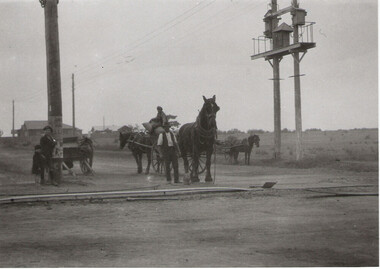 City of Moorabbin Historical Society (Operating the Box Cottage Museum)
Photograph - Plateway (Wheelway) Steel, circa 1885
... along Nepean Highway, but it soon extended from Centre Dandenong... along Nepean Highway, between Asling St. and Bay St. The Point ...By the later 1800s the dirt roads in the then out-lying areas of the City of Moorabbin became dangerous, and almost impassable due to huge potholes and muddy swampy areas. The heavily laden market gardener’s carts regularly broke axles and wheels, and horses foundered on their way to the Melbourne markets. Even worse, the heavier “iron maidens”, carrying their malodorous loads of sewage from Melbourne’s inner suburbs for dumping in the outlying areas of the City of Moorabbin, also got bogged in the mire. It was decided that a practical solution to this problem was to install a metal plateway on the side of the problematic roads. In about 1887 the Moorabbin Shire Centre Road, in the Brighton East area, two parallel metal rails were installed so that the wheels of carts could run along smoothly, the horse travelled in the filled, middle area between the rails. Point Nepean Road plateway was removed in 1930 and Centre Dandenong Road plateway was removed in 1934-35. The worn plateway along Centre Road, East Brighton (now known as Bentleigh), was gradually taken up in several pieces, commencing in the the1920s, when its condition deteriorated and it caused a hazard to bikes, pedestrians, motor-cycles and the few early cars. The early steel plateway, constructed by David Munro, and opened on 23rd March 1885 by Thomas Bent, was built along Nepean Highway, between Asling St. and Bay St. The Point Nepean Track was subsequently extended into Moorabbin with branches along Centre, Cumins, South, Wickham, and Keys Roads, the total length was 13 miles. In 1908-1909 plates were laid along Centre Dandenong Road to Ross Street Bentleigh This innovative solution proved successful and was used until gradually the main roads were upgraded, and motorised vehicles started to appear. Two parallel metal rails were installed in the right hand side of a few main roads in the Shire of Moorabbin so that the wheels of heavily-loaded market gardener's carts on their way to markets in Melbourne could run along smoothly. The horse pulling the carts travelled in the filled, middle area between the rails. The Steel Plateway was constructed by David Munro, and opened on 23rd March 1885 by Thomas Bent. The wheelway first only ran along Nepean Highway, but it soon extended from Centre Dandenong Road, along Nepean road to its junction with Chapel Street, St Kilda. Later branch lines were built along Centre Road, Bentleigh as far as Warrigal Road and, according to early photographs, along Wickham Road Moorabbin as well. This innovative solution proved successful and was used until gradually the main roads were upgraded, and motorised vehicles started to appear. There was a problem with the wheelway : there was only a single set of rails and this was established on the right-hand side of the Nepean Road, travelling towards the city. Traffic FROM the city travelled on the correct or left-hand side of the road. The exception to this rule was the malodorous iron-clads, heavily riveted iron carts, generally travelling in convoy, carrying several tons of human effluent out of Melbourne to be trenched-in in the sandy soil of the Moorabbin district. Moorabbin City Council donated and installed a small section of Plateway at Box Cottage Museum in 1984melbourne, brighton, moorabbin, roads, plateway, wheelway, transport, st kilda, bent thomas, munro david, market gardens, steelway, carts horse-drawn, iron maidens, point nepean track -
 Glen Eira City Council History and Heritage Collection
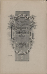
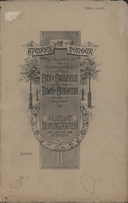
Booklet, "AVENUES OF HONOUR The Councils of the Municipalities of the CITY OF CAULFIELD TOWN OF BRIGHTON acting in conjunction PUBLIC DEMONSTRATION SAT 3rd AUG. 1918 AT 3oCLOCK"
... , McMillan Street and Point Nepean Road (now Nepean Highway... Street and Point Nepean Road (now Nepean Highway). The Avenue ...Souvenir Programme from the Councils of the Municipalities of the City of Caulfield and the Town of Brighton for a Public Demonstration to be held on Sat 3rd August 1918 at 3 o'clock for the proposed Avenues of Honour to be planted in memory of fallen WWI soldiers. From Honour Roll Display 2019 interpretation panel - Brighton-Caulfield Avenue of Honour It is hard to imagine but a grand arboreal Avenue of Honour once lined parts of North Road, McMillan Street and Point Nepean Road (now Nepean Highway). The Avenue of Honour was a distinctly Australian phenomenon with hundreds being constructed throughout Australia during and following World War One, most of these in Victoria. Consisting of tree lined streets with each tree representing a solider, the Avenue of Honour signalled a more egalitarian approach to commemoration where rank was not a consideration. Arguably the most famous Avenue of Honour in Victoria still exists at Ballarat. Stretching for nearly 22 kilometres, the entrance to the Avenue is marked by the imposing Arch of Victory. Smaller in scale, the Brighton-Caulfield Avenue of Honour was dedicated to the ‘memory of (Brighton and Caulfield’s) kith and kin who came from (the) district and who died in the Great War’. A joint project between the neighbouring Councils, the idea was first reported in The Argus on 1 July 1918. Plans moved along quickly and on 3 August 1918 the Governor of Victoria Arthur Stanley planted the first Australian flowering gum. The next of kin were then invited to plant trees for lost sons, brothers, uncles, nephews and husbands. In all, over 400 trees were planted. Intensely personal, the Avenue also acted as a focus of grief and remembrance for the wider community. For many years, the annual civic Anzac Day service was held at the Avenue on Point Nepean Road, near Glen Huntly Road, Elsternwick. The service was moved to Caulfield Park upon the completion of the Cenotaph in 1930. Due to road widening and disease the last original tree was replaced in the 1980s, however a plaque in Caulfield Park records the Avenue’s plantation. Commemorative booklet, grey cover with text printed on the grey textured paper cover and an image of four trees and a wreath. Image of a kookaburra on the back. Inside, 28 numbered pages with b/w text and photographic images including a transparent paper representation of the proposed Avenues of Honour on Brighton Road and Point Nepean Road. Souvenir programme for a Public Demonstration for the Avenues of Honour as detailed on the front.city of caufield, world war one, first world war, anzac, remembrance, town of brighton, brighton, caulfield, avenue of honour -
 Brighton Historical Society
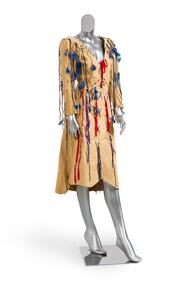
Clothing - Dress, c. 1974
... of a bike path along Nepean Highway and the first Brighton Festival... Nepean Highway and the first Brighton Festival, while balancing ...This dress was worn by Brighton's first female mayor, Councillor Di Lopez, to a Mayoral Ball held at Brighton Technical School in 1977. Diane Margaret Lewis completed a law degree at the University of Melbourne, later marrying one of her classmates, criminal lawyer Ramon (Ray) Lopez. When she decided to run for the Brighton City Council in 1975, she was seen as an outside chance. Undeterred, she rallied a small group of friends and supporters and set out on an extensive door-knocking campaign that won voters to her side and successfully unseated former mayor Keith Devenport. She went on to serve two terms on council from 1975 to 1981. Di initiated many local projects, including the creation of a bike path along Nepean Highway and the first Brighton Festival, while balancing family life and a demanding ‘day job’ as personal assistant to Victorian Minister for Youth, Sport and Recreation Brian Dixon. She was a member of the Women’s Electoral Lobby and a champion for women’s representation, encouraging both Sally Allmand and Kate Harman to run for council (both were successfully elected). She advocated forcefully for an open, transparent local government in which ratepayers had the chance to participate and be heard. In 1976 Di became the first woman to hold the title of Mayor of Brighton, and she made it clear from the outset that she was going to do it her way. For the annual mayoral ball in 1977, ordinarily a staid traditional function, she chose a discotheque theme based on the Rod Stewart album Night on the Town, with a broad dress code of ‘black tie or jeans’: ‘You’ve got to get with the times,’ she said. ‘We want people to wear whatever they feel comfortable in.’ Di herself chose to attend in this knee-length chamois dress embellished with strings, ribbons, beads and feathers. It was both a fashion statement, exemplifying her colourful, flamboyant and forthright style, and a political one: a declaration of her intention to lead a progressive council, embracing the new and refusing to be hemmed in by dated traditions. In 2020 she was awarded an Order of Australia Medal for her service to local government and to the community of Brighton.This dress has local historical significance for its association with Brighton's first female mayor, Councillor Di Lopez, who wore it to a Mayoral Ball in 1976. The dress exemplifies her flamboyant reputation, modern outlook and willingness to break norms. At the time, the dress was a radical choice for a Mayoral Ball, where women typically wore formal evening gowns. With her choice of dress, Cr Lopez was making a public statement, breaking away from dated traditions and announcing her intention to bring the Mayor's office into the 1970s. In this way, the dress also points to the wider social and political changes taking place both in Brighton and across Australia during the mid-1970s.Three quarter length chamois dress circa 1974. Machine stitched with a v-neck and full length sleeves and an uneven raw hem, the dress is decorated with narrow thongs of chamois embellished with red beads and blue feathers. The open-fronted bodice is laced with red ribbon and the skirt is decorated with a large blue wool cross stitch and a combination of blue wool and purple ribbon cross stitch. Made in the style of an Indian 'Wild West Dress'.di lopez, chamois, brighton, brighton council, brighton technical school, mayoral ball, 1970s, feminism -
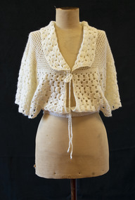 Brighton Historical Society
Bed jacket, circa 1955
... manufacturer on Nepean Highway, and paid for her passage. Carmela... at the Brighton Case Company, a box manufacturer on Nepean Highway ...This bed jacket was crocheted for Carmela Materia (1931-2018) by her mother, Giuseppa Auditore, around the time they emigrated from Italy to Melbourne. Both women were longtime Brighton locals, residing in the area from the 1950s until their deaths. Carmela Auditore was the first woman from her home village of Scaletta, Italy to emigrate to Australia. Setting sail alone in 1950 at the age of 19, she joined her brother John and uncle Frank in McCallum St, Brighton. Frank had arrived some years earlier and had spent the duration of the First World War in an internment camp. John worked at the Brighton Case Company, a box manufacturer on Nepean Highway, and paid for her passage. Carmela found a job sewing children's clothing at Drummonds, a small factory in Church St. Working eight hours a day, five days per week, netted her a weekly wage of three pounds. To earn a little extra, she washed dishes at a St Kilda Road restaurant for ten shillings a shift. Her parents, Salvatore and Giuseppa Auditore, joined her in Brighton in 1952. They rented a house behind an antique shop in Bay Street. Salvatore had been a fisherman in Scaletta, but quickly adapted to the job he found helping around the Garage at Brighton Motors in Male Street. On 14 February 1953, Carmela married her sweetheart, Salvatore Materia, at St James Catholic Church in Gardenvale. Salvatore had been living with his aunt in Well Street and worked on the wharves. Both Carmela and Salvatore were hard workers. They owned a fruit shop in Church Street where Woolworths now stands, and years later Carmela recalled the familiar 6am tap on her window each morning when her husband returned from the market. On dark winter mornings, she felt as if her hands would freeze as she helped Salvatore unload cold cabbages and cauliflowers from his truck. They later owned a shop in Ludstone Street in Hampton. After Salvatore died suddenly at the age of 48, Carmela returned to sewing, working at the Willow Fashions knitting mill in Gardenvale. She later went into partnership with her sister and brother-in-law, this time in the delicatessen business. Her parents, Giuseppa and Salvatore, spent the rest of their days with Brighton. Carmela recalled her father cheerfully walking the streets, greeting people by name. He knew everybody. He loved being in Australia and enjoyed life to the last, insisting on having bread and wine on the table at every meal.Cream crocheted wool bed jacket. Loose around bust with wide sleeves and open sides. Fastens at collar with thin braided ties, and at waist with two pearlescent plastic buttons.bed jacket, migration, 1950s, carmela auditore, carmela materia, giuseppa auditore -
 Glen Eira City Council History and Heritage Collection
Booklet, D. W. Paterson Co. Pty. Ltd, "AVENUES OF HONOUR The Councils of the Municipalities of the CITY OF CAULFIELD TOWN OF BRIGHTON acting in conjunction PUBLIC DEMONSTRATION SAT 3rd AUG. 1918 AT 3oCLOCK SOUVENIR"
... , McMillan Street and Point Nepean Road (now Nepean Highway... of the proposed Avenues of Honour on Brighton Road and Point Nepean Road ...Souvenir Programme from the Councils of the Municipalities of the City of Caulfield and the Town of Brighton for a Public Demonstration to be held on Sat 3rd August 1918 at 3 o'clock for the proposed Avenues of Honour to be planted in memory of fallen WWI soldiers. One of two known copies, this copy has "Town Clerk" stamped in the upper corner, rhs.Commemorative booklet, grey cover with text printed on the grey textured paper and an image of four trees and a wreath. Image of a kookaburra on the back. Inside, 28 numbered pages with b/w text and photographic images including a transparent paper representation of the proposed Avenues of Honour on Brighton Road and Point Nepean Road. Souvenir programme for a Public Demonstration for the Avenues of Honour as detailed on the front. From Honour Roll Display 2019 interpretation panel - Brighton-Caulfield Avenue of Honour It is hard to imagine but a grand arboreal Avenue of Honour once lined parts of North Road, McMillan Street and Point Nepean Road (now Nepean Highway). The Avenue of Honour was a distinctly Australian phenomenon with hundreds being constructed throughout Australia during and following World War One, most of these in Victoria. Consisting of tree lined streets with each tree representing a solider, the Avenue of Honour signalled a more egalitarian approach to commemoration where rank was not a consideration. Arguably the most famous Avenue of Honour in Victoria still exists at Ballarat. Stretching for nearly 22 kilometres, the entrance to the Avenue is marked by the imposing Arch of Victory. Smaller in scale, the Brighton-Caulfield Avenue of Honour was dedicated to the ‘memory of (Brighton and Caulfield’s) kith and kin who came from (the) district and who died in the Great War’. A joint project between the neighbouring Councils, the idea was first reported in The Argus on 1 July 1918. Plans moved along quickly and on 3 August 1918 the Governor of Victoria Arthur Stanley planted the first Australian flowering gum. The next of kin were then invited to plant trees for lost sons, brothers, uncles, nephews and husbands. In all, over 400 trees were planted. Intensely personal, the Avenue also acted as a focus of grief and remembrance for the wider community. For many years, the annual civic Anzac Day service was held at the Avenue on Point Nepean Road, near Glen Huntly Road, Elsternwick. The service was moved to Caulfield Park upon the completion of the Cenotaph in 1930. Due to road widening and disease the last original tree was replaced in the 1980s, however a plaque in Caulfield Park records the Avenue’s plantation. Inkstamp upper corner rhs: "TOWN CLERK" -
 City of Moorabbin Historical Society (Operating the Box Cottage Museum)
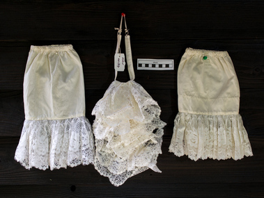
Ceremonial object - Clothing, 'Jabot' style collar and cuffs Moorabbin City Council Mayoral Robes, c1960
... at Kingston City Council Offices Nepean Highway Cheltenham . clothing ...In clothing, a collar is the part of a shirt, dress, coat or blouse that fastens around or frames the neck and may be permanently attached to the main body of the garment (e.g. by stitching) or detachable. Today's shirt collars descend from the ruffle created by the drawstring at the neck of the medieval chemise, through the Elizabethan ruff and its successors, the whisk collar and falling band. Separate collars exist alongside attached collars since the mid-16th century, usually to allow starching and other fine finishing. Jabots made of lace and hanging loose from the neck were an essential component of upper class, male fashion in the baroque period. During the Edwardian period, and sporadically thereafter, ornamental collars were worn as a form of jewellery. Names for specific styles of collars vary with the vagaries of fashion. Jabots survive in the present days as components of various official costumes, as are those worn by judges and counsel throughout Australian courts and town mayors. 2018 Kingston City Council Mayor Steve Staikos asked CMHS to loan the Former Moorabbin Mayoral Robes and Jabot for display at KCC Office Cheltenham. These Moorabbin Mayoral Robe with Jabot are now displayed along with those of the former City of Chelsea Robe and the former City of Mordialloc Robe at Cheltenham . KCC possesses the original Mayoral Chains of each former Council and they are displayed on each Robe for the annual Opening Meeting of KCC in February. This set of a 'Jabot' style collar and cuffs was part of the ceremonial Mayoral Robes c1960- 94 for the City of Moorabbin 1934-94. This is the last City of Moorabbin Mayoral Robe and was worn by Mayor Ron Brownlees, (prior to amalgamation with the City of Glen Eira and City of Kingston in 1994), and donated to the City of Moorabbin Historical Society in February 2007 by the City of Kingston. The City of Moorabbin developed from the Moorabbin Roads Board of 1862, becoming The Shire of Moorabbin in 1871 and the City of Moorabbin in 1934. November 2018 At the request of the Mayor Cr Steve Staikos this Jabot Collar and Cuffs is now on display with the Mayoral Robes at Kingston City Council Offices Nepean Highway Cheltenham . A detachable , white, nylon, 'Jabot' style, standing collar with a pleated, ruffled, and lace-trimmed frill down the front and 2 matching cuffs that was part of the City of Moorabbin Mayoral Robes c1960 - 94 It has a tear in corner. clothing, collars, ornamental collars, civic robes, mayoral robes, moorabbin, cheltenham, bentleigh, lacework, dressmaking, fashion, formal wear, city of moorabbin. moorabbin shire, moorabbin roads board, brownlees ron, city of glen eira, city of ikngston -
 City of Moorabbin Historical Society (Operating the Box Cottage Museum)
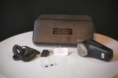
Personal Effects. 'Philips" electric Shaver, c1977
... Chinese market gardeners at the Hotham St. / Nepean Highway corner ...Established in 1891 in Eindhoven, the Netherlands, Philips & Co. was founded to meet the growing demand for light bulbs following the commercialization of electricity. Science and technology underwent tremendous development in the 1940s and 1950s, with Philips Research inventing the rotary heads that led to the development of the Philishave electric shaver, and laying down the basis for later ground-breaking work in transistors and integrated circuits.Philishave was the brand name for the electric shavers manufactured by the Philips Domestic Appliances and Personal Care unit of Philips They used the Philishave brand name for their shavers from 1939 to 2006. The Philishave shaver was invented by Philips engineer Alexandre Horowitz, who used rotating cutters instead of the reciprocating cutters that had been used in previous electric shavers. The shaver was introduced in 1939, though initial production was limited due to the outbreak of World War II. A more ergonomic egg-shaped single-head model was introduced in 1948 and was designed by US industrial designer Raymond Loewy. Global sales increased markedly after a double-head model was introduced in 1951. As a spin off from the light bulb and research is the dynamo-powered bicycle lamp. Its rotating power system inspires the Philishave triple head electric razor. A triple-head model was test marketed in Australia and New Zealand in 1956, but would not be introduced globally until 1966. The brand name Philishave was phased out in 2006 so shavers now bear only the Philips name. Mr Alfred William ( Bill ) Roper, 1913 - 1996 grew up in Ripponlea, ( East St Kilda ) Victoria. As a child he went with his father Arthur Leopold Roper to purchase vegetables from the Moorabbin Chinese market gardeners at the Hotham St. / Nepean Highway corner. c1920 . Bill served in WW2 in New Guinea and post war was Army Auditor, Victoria Barracks, St Kilda Road Melbourne. His staff presented this 'Philishave upon his retirement and he used it until his death1996. He lived in Carlton, Belgrave, Ascot Vale, South Yarra, East St Kilda and moved to Bentleigh in 1987.A ‘Philishave’ triple head electric razor , with cord, head protector and cleaning brush in a hinged plastic case The case has compartments, for Razor and cord, that are lined with a mustard coloured, soft, synthetic material .Case top PHILIPS ; inside EXCLUSIVE PHILISHAVE Razor Handle front PHILIPS / PHILISHAVE; back Type HP 1121/ 110-130V/ 220-240 V / PHILIPS Shield / ? Shield / BS 3456 / V 75255 / MADE IN HOLLAND Nameplate Presented to / BILL ROPER / On the occasion of his retirement / BY THE STAFF OF / DEFENCE AUDIT BRANCH / May 1977 philishave, royal philips electric company, razors, electric razors, bentleigh, moorabbin, market gardeners, st kilda markets, world war 2 1939-1945, department of defence melbourne, melbourne, roper alfred william, roper arthur leopold, ripponlea, chinese market gardeners -
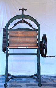 City of Moorabbin Historical Society (Operating the Box Cottage Museum)
Functional object - Laundry equipment, Mangle, c1900
... 1900s This large Mangle was used at The Exchange Hotel, Nepean ...The mangle was used in the laundry at Key's, Exchange Hotel. This large, iron framed, manual, machine with 3 cylinders for rolling and pressing washed clothes was a prominent and necessary piece of equipment used by early settler women in Moorabbin Shire 1800 to mid 1900sThis large Mangle was used at The Exchange Hotel, Nepean Highway, Cheltenham , built in 19thC , now known as The Tudor Inn.A large, iron framed, manual, machine with 3 cylinders, for rolling and pressing washed clothes, connected by cogs manually operated by turning a side wheel with a large crank handle.On an oval plate at base of iron frame 'W. Summerscales / & Sons / Keighley Englandclothing, brighton, moorabbin, linen, washing machine, bentleigh, market gardeners, laundry equipment, mangle, early setters pioneers -
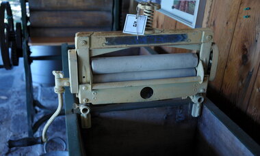 City of Moorabbin Historical Society (Operating the Box Cottage Museum)
Functional object - Laundry Eqipment , 'ACME' clothes wringer, mid 20thC
... burden of the women. The Exchange Hotel Nepean Highway Cheltenham ...This ACME portable clothes wringer could be attached to a wash trough or hand washing machine to remove excess water from the washing. It was much less cumbersome that the earlier Mangles used for this purposeMost homes of 20th C in City of Moorabbin would have had one of these ACME wringers . It greatly eased the washday burden of the women. The Exchange Hotel Nepean Highway Cheltenham was a well established meeting place for Moorabbin Shire settlers by 1915A metal clothes wringer with side hand crank and 2 rollers that could be attached by screw clamps to a wash trough or washing machine for removing excess water from washing. The pressure of 2 rollers was controlled by a screw on the top of machine that could be loosened or tightened according to the material being passed through.ACME 14 INCH / on hand crank is list of patents for Great Britain, USA, Aust. NZ, Germany, Belgium, Sweden moorabbin, bentleigh, cheltenham, laundry equipment, washing, washing mangles, washing machines -
 City of Kingston
Photograph - Colour, 6 March 1993
... residential with a shopping strip along Nepean Highway but little ...Edithvale is a suburb in the City of Kingston. It is located between Aspendale and Chelsea on the Port Phillip Bay and built within remnant areas of the Carrum Carrum swamp. The foreshore precinct comprises a wide sandy beach, with low sand dunes and numerous historic boat sheds. The suburb consists of older style dwellings and former holiday houses, combined with mid-century housing and newer homes. The large blocks are increasingly subdivided and the existing dwellings demolished to accommodate units and townhouses, thus changing the landscape of the area and reducing the tree canopy.The beachside suburb of Edithvale was previously part of the extensive Carrum Carrum Swamp. The area was once a source of fish and eels for the Mayone-Bulluk clan of the Bunurong people. Over time the area was drained and predominantly devoted to dairy farming and holiday houses. The farms were gradually sold and subdivided with a large number of homes built after World War II and in the 1960s. Edithvale is mainly residential with a shopping strip along Nepean Highway but little significant industry was ever established in the area apart from a plaster works and confectionary factory, both now closed.Laminated aerial colour photograph of Edithvale as viewed from Alexandra Avenue in the north to Ella Grove Chelsea/Edithvale in the south. regents Park Aspendale can be seen in the top left. The area is built-up with residential housing and facilities including Edithvale Primary School, numerous churches and the Edithvale Railway station. Large sections depict the remnant Carrum Carrum swamp. Edithvale Common and the former "Duck Inn" (Melbourne Water/Friends of Edithvale Seaford Wetlands) can be seen. Edithvale Recreational reserve, the valodrome and Edithvale Public Golf Course are prominent. The image shows vacant land in the area now known as Aspendale Gardens and the newer residential section of Chelsea Heights is not developed. A bike path has been established to cover the secondary drain. The Golf Links Court residential development located off Hughes Avenue is a large vacant block.Black type on white adhesive label: 6-3-93 Black type on white adhesive label: 25/9211, 6/3/93, 11.20 am Black type on white adhesive label: 9211 Yellow circular adhesive sticker Black pencil: 9211 6-3-93 arrow pointing Nedthvale, carrum carrum swamp, aspendale, chelsea -
City of Kingston
Photograph - Colour, Circa 1993
... residential with a shopping strip along Nepean Highway but little ...Edithvale is a suburb in the City of Kingston. It is located between Aspendale and Chelsea on the Port Phillip Bay and built within remnant areas of the Carrum Carrum swamp. The foreshore precinct comprises a wide sandy beach, with low sand dunes and numerous historic boat sheds. The suburb consists of older style dwellings and former holiday houses, combined with mid-century housing and newer homes. The large blocks are increasingly subdivided and the existing dwellings demolished to accommodate units and townhouses, thus changing the landscape of the area and reducing the tree canopy.The beachside suburb of Edithvale was previously part of the extensive Carrum Carrum Swamp. The area was once a source of fish and eels for the Mayone-Bulluk clan of the Bunurong people. Over time the area was drained and predominantly devoted to dairy farming and holiday houses. The farms were gradually sold and subdivided with a large number of homes built after World War II and in the 1960s. Edithvale is mainly residential with a shopping strip along Nepean Highway but little significant industry was ever established in the area apart from a plaster works and confectionary factory, both now closed.Aerial colour photograph of Edithvale as viewed from Alexandra Avenue in the north to Ella Grove Chelsea/Edithvale in the south. The area is built-up with residential housing and facilities including Edithvale Primary School, numerous churches and the Edithvale Railway station. Large sections depict the remnant Carrum Carrum swamp. Edithvale Common and the former "Duck Inn" (Melbourne Water/Friends of Edithvale Seaford Wetlands) can be seen. Edithvale Recreational reserve, the velodrome and Edithvale Public Golf Course are prominent. The image shows vacant land in the area now known as Aspendale Gardens and the newer residential section of Chelsea Heights is not developed. A bike path has been established to cover the secondary drain. The Golf Links Court residential development located off Hughes Avenue is a large vacant block.Yellow circular adhesive sticker on plastic Black ink (marker): * (asterisk) Black type on white adhesive sticker: P000108edithvale, aspendale, chelsea, carrum carrum swamp