Showing 1360 items matching "parks and reserves"
-
 Bendigo Historical Society Inc.
Document - PRESENTATION TO BHS 7TH JULY 2000: ''CAMP RESERVE'', 7th July 2000
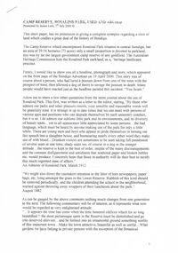
Presentation by James Lerk to BHS 7th July 2000: ''Camp Reserve -Rosalind Park, used and abused''. First line: ''This short paper has no pretension in giving a complete synopsis regarding a slice of land which cradles a great deal of the history of Bendigo''. References to Commissioner Gilbert; Bank of Victoria; Bendigo Bank; powder magazine; post office; Survey Office; Court of Petty Sessions; Police Barracks; Supreme Court; Gaol; Temperance Society; Robert Strickland residence; tenements on Reserve; Mac's Track; Orderly Room; Cascades; Corporate High School; Temperance Fire Brigade; Masonic Hall; Central School Camp Hill; Fernery; ''The Willows''; Conservatory; Parade Ground; Sandhurst Club; Police Station; Grandstand in Upper Reserve; High School; Soldiers Memorial Insitutute; Lookout (poppet head - Garden Gully United); Advance Bendigo and North League crèche; Sound Shell; Olympic Swimming Pool. Two printed copies.James Lerk.bendigo, streetscape, camp reserve, rosalind park, bendigo creek -
 Greensborough Historical Society
Book, Sue Ballantyne et al, The Partingtons Of Greensborough, 2024
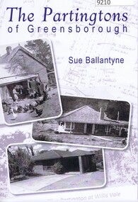
History of the Partington Family of Greensborough; from their arrival in Australia in 184 , including the purchase of land in Greensborough and the subsequent compulsory acquisition of some of this land for parks and reserves by various local government authorities. An edited version of family histories by descendant Faye Fort (nee Partington) is included in part 2 of the book.Sourced from family documents and primary sources.Soft Covered book with black and white text and images in black and white, colour, sepiapartington family, greensborough, local history, whatmough park, partingtons flat, yandell reserve, faye fort (nee partington) -
 Bendigo Historical Society Inc.
Document - HUSTLERS REEF - PLANS & SECTIONS TO ACCOMPANY BULLETIN NO 33
Pink page pasted onto cream card titled Plans and Sections to accompany Bulletin No 33. Hustler's Line of Reef, Bendigo by H S Whitelaw, by Authority: Albert J. Mullett, Government Printer, Melbourne. Plate No 1 to No 34. Mines mentioned: Fortuna Hustler's Mine, Hustler's Royal Reserve No 2 Mine, Hustler's Royal Reserve Mine Park Shaft, Great Extended Hustler's Mine, Hustler's Reef and Hustler's Reef No 1 Mines, Hustler's Reef Mine, Comet Mine, United Hustler's and Redan Mine, K. K. Mine, Hustler's Consols Mine, Fortuna Hustler's Mine. Department of Mines Geological Survey of Victoria 1914. Written on the back: Lightning Hill area to Summer Hill.document, hustlers reef, plans & sections to accompany bulletin no 33, geological survey of victoria, department of mines, hustler's line of reef, h s whitelaw, fortuna hustler's mine, hustler's royal reserve no 2 mine, hustler's royal reserve mine park shaft, great extended hustler's mine, hustler's reef mine, hustler's reef no 1 mine, comet mine, united hustler's mine, redan mine, k k mine, hustler's consols mine, fortuna hustler's mine, hustler's consols mine, albert j mullett, government printer melbourne -
 Bendigo Historical Society Inc.
Document - Geological Survey of Victoria, Hustlers Line of Reef, Bendigo, April, 2014
Seven men were killed at the Great Extended Hustler's mine disaster on 2nd May 1914 by an explosion of dynamite occurring as the men were waiting at the plat to ascend the mine at the end of their shift. No blame was attached to anyone in the findings of the inquisition. It was unknown what caused the dynamite to explode. This document formed part of the research done at the time by Bendigo Historical Society, of the 100 years commemoration of the mine disaster, held at Hustler's Hill in 2014. Seven page photocopy of Department of Mines, Bulletin, Geological Survey of Victoria, Hustlers Line of Reef, Bendigo, No. 33 by H.S. Whitelaw. Includes plan of Hustlers Royal Reserve No. 2, (main shaft) showing location on Pall Mall, and location of Post Office and Law Courts; plan of location of Hustlers Royal Reserve No. 2 (Park Shaft) showing Jail (sic), Camp Hill State School, two 'lagoons' in between tennis court, croquet court and bowling green; a plan of the Great Extended Hustler's Shaft and two copied images of Hustler's Hill showing mining buildings, poppet heads and chimneys. Comet, K.K., Hustler's No. 1, Old Comet and United Hustler's and Redan Mines are shown in the images. great extended hustlers, goldmining, accident, quartz, mining, k.k. mine, comet mine, hustler's line of reef, old comet, united hustler's, redan -
 Bendigo Historical Society Inc.
Document - Regulation of Mines Bill, famous mines of Bendigo, April, 2014
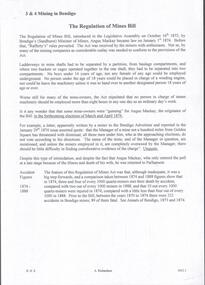
Seven men were killed at the Great Extended Hustler's mine disaster on 2nd May 1914 by an explosion of dynamite occurring as the men were waiting at the plat to ascend the mine at the end of their shift. No blame was attached to anyone in the findings of the inquisition. It was unknown what caused the dynamite to explode. Three page typed document. First page: 'The Regulation of Mines Bill' by Albert Richardson; Angus Mackay, Minister of Mines introduced the Bill in the Legislative Assembly on October 16th 1873 and it became law on January 1st 1874. Second page: 'Famous Gold Mines of Bendigo and Eaglehawk' by Albert Richardson, discusses deep shafts, more than 4000 feet shafts, wages for 1911. Hustler's Line of Reef mines are listed from north to south: Hustler Consols; United Hustler's and Redan, K.K., Comet, Hustler's Reef No. 1, Hustlers Reef, Great Extended Hustlers (formed 4.2.1865) Hustler's Royal Reserve Co., (Park Shaft) Hustler's Royal Reserve (City Shaft) and Fortuna Hustler's (formed August 1888).great extended hustlers, goldmining, accident, quartz, mining, k.k. mine, comet mine, hustler's line of reef, old comet, united hustler's, redan -
 St Kilda Historical Society
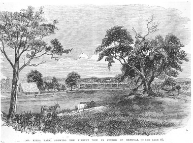
Photograph - Photograph of artwork, St Kilda Park, showing the viaduct now in course of removal, 25/06/1867
St Kilda Park, now Albert Park Reserve, showing cows, eucalyptus trees, oval and a railway viaduct in background. The viaduct was part of the Windsor to St Kilda loop line which operated between 1857 and 1867. The loop line ran from the St Kilda railway station on a combination of wooden viaducts and earth embankments fifteen feet high, crossing over St Kilda and Punt Roads by way of bridges and then gradually decreasing to a level crossing at Union Street and then on to Windsor station. Black and white photograph of a lithograph published in a book (unidentified)ST KILDA PARK, SHOWING THE VIADUCT NOW IN COURSE OF REMOVAL - SEE PAGE 85st kilda railway station, albert park, windsor to st kilda rail loop -
 Eltham District Historical Society Inc
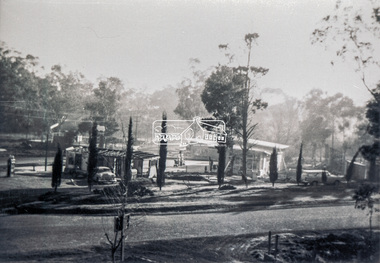
Slide - Photograph, Grace Mitchell, Golden Fleece Service Station at the corner of Main Road and Mount Pleasant Road, Eltham, c.1961
View from Grace Mitchell's shop at the corner of Mount Pleasant Road and Main Road. Grace Mitchell was probably best known for her Eltham shop at the corner of Mt Pleasant Road and Main Road. Grace's memories covered many local identities who were patrons of her shop between 1954 and 1971. From the elevated position of her shop and home Grace was able to view a varied passing parade of Eltham events from ERSILAC, Easter and Eltham Festival parades passing on their way to Eltham Lower Park, circuses in Wingrove Park (then Bremner’s Reserve), roadworks and other happenings. Bremner's Reserve was renamed Wingrove Park c.1970 This photo was from a series of images presented by Grace Mitchell at a Society talk 10 March 1993 on the theme of “My Eltham”. The Holden wagon appears to be an FB or EK model with finned rear taillights. The FB was produced January 1960-May 1961 and the EK May 1961 to July 196235mm Kodak 5052 TMX Black and White transparency, 1 strip, 6 frames Black and white print 17 x 25.4 cmgolden fleece service station, main road, mount pleasant road -
 The Beechworth Burke Museum
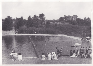
Photograph, 1960s
Taken in the 1960s, depicted are approximately twenty-nine male and female spectators at a school swimming carnival on Lake Sambell near the caravan park. Lake Sambell is a beautiful Victorian recreation lake and urban park with a unique history. It was created in the mid-1800s by the Rocky Mountain Mining company during the gold rush era and used as a mining site until the early 1900s, which brought Europeans into the area. It was turned into a reserve for residents in 1920 and is considered an icon of Beechworth as it represents the development of the community, human endeavour, and the spirit of the landscape. This photograph represents the post-gold rush era use of Lake Sambell as a recreational reserve. Swimming carnivals were held at the lake and considered a social event for the Beechworth community.Black and white reproduced rectangular photograph print on paper.Reverse: Community/ Swimming pool 1960s/ near the caravan park/ Lakes?lake swimming pool, lake swimming, beechworth carnival processions, carnival, #beechworth, beechworth 1960s, victoria -
 Greensborough Historical Society
Map, Melbourne and Metropolitan Board of Works. Survey Division, MMBW, Yarra 2500 / 15.21. Eltham North, 1979_08
Melbourne and Metropolitan Board of Works. Yarra 2500 [base map] 15.21. Eltham North. Parish of Nillumbik 3310. Municipalities of Diamond Valley 257 and Eltham 238. Prominent streets include: Progress Road, Glen Park Road and Zig Zag Road. Features include the Diamond Creek, Eltham Council Pound and Eltham North Reserve.MMBW Map in 1:2500 [scale] series. Cream parchment with green tape reinforcing on edges and punched holes on left edge.mmbw, melbourne and metropolitan board of works, shire of diamond valley, nillumbik, eltham - maps -
 Rutherglen Historical Society
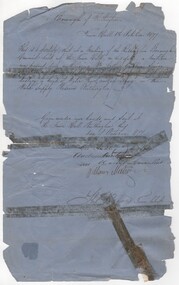
Document - Council permit, 1877 (Exact)
Letter granting permission to Mr Arthur Gribbin to shoot shag on the Water Supply Reserve. Mr Gribble was senior Constable of Police stationed at Rutherglen. Water supply came from Lake King in the park. Councillors signing were Geo. Audley / Andrew Hunter (M. Gunter?) William Meehan. [check names - Gribbin - Gribble]Document written in black ink on blue paper, stamped with seal of Rutherglen Municipality, granting permission to Mr Arthur Gribbin to shoot shag on the Water Supply Reserve"Borough of Rutherglen / Town Hall / Rutherglen / 1st October 1877" Signed by Councillors and Town Clerk Thos. Reevespermit, water supply reserve, lake king, shag, rutherglen borough -
 Greensborough Historical Society
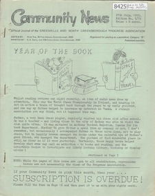
Newsletter, Greenhills and North Greensborough Progress Association, Community News: official journal of the Greenhills and North Greensborough Progress Association. 27th July, 1972. Edition No. 5/72, 27/07/1972
This edition includes a report on the Progress Association's July 1972 meeting, Year of the Book, Spring planting time, School and kinder news, Letter to the editor, Megalopolis or the bush, Parks, gardens and reserves, Eltham Film Society. Supplement to July 1972 "Community News" Open forum. A digital copy of this Newsletter is available from Greensborough Historical Society.Newsletter, 16 p., illus. greenhills and north greensborough progress association, greenhills -
 Eltham District Historical Society Inc
Photograph, Fay Bridge, Save Community Reserves Rally, 895 Main Road, Eltham, 7 November 2017
... Save Community Reserves Rally, 895 Main Road, Eltham...Parks ...Protest rally against Nillumbik Shire Councillors' proposal to sell off 17 community reserves. Held at the site of the former Shire of Eltham offices, at 895 Main Road, which were demolished in August 1996, followed by a march along Main Road finishing at the Eltham Railway Station car park at Luck Street. Estimated attendance was approximately 3,000.fay bridge collection, 895 main road, 2018-03-04, margaret jennings, nillumbik shire council, parks, save community reserves protest rally, save our reserves -
 Greensborough Historical Society
Photograph - Digital Image, Pioneer Reserve 2014 -2, 01/10/2014
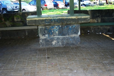
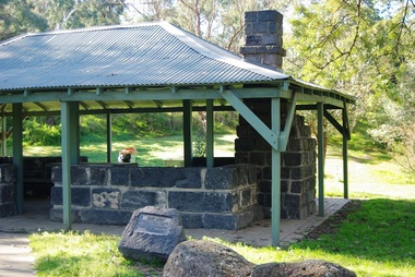
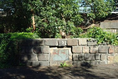
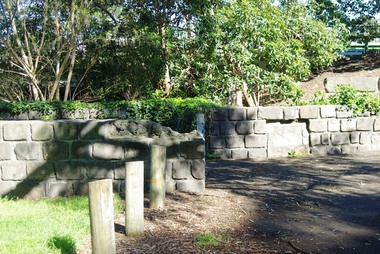
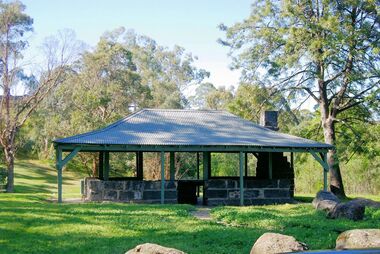
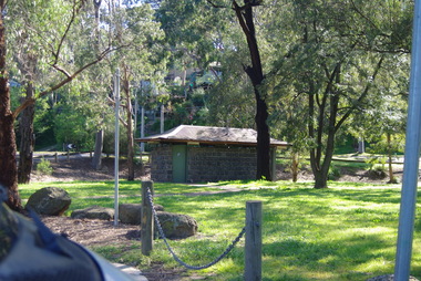
Pioneer Reserve, Greensborough is a small park on the corner of St Helena and Diamond Creek Roads. It is adjacent to the site of Greensborough's first bridge across the Plenty River, c. 1864 - 1960s. The shelter, viewing platform, retaining wall and entrance are built from the bridge's massive bluestone arched abutments dismantled between 1974 and 1983. Photograph by Marilyn Smith 2014.Digital copy of colour photograph.pioneer reserve greensborough -
 Greensborough Historical Society
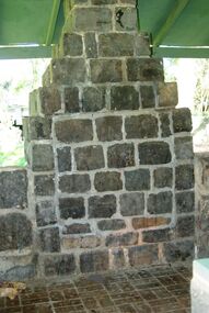
Photograph - Digital Image, Pioneer Reserve 2014 -3, 01/10/2014
Pioneer Reserve, Greensborough is a small park on the corner of St Helena and Diamond Creek Roads. It is adjacent to the site of Greensborough's first bridge across the Plenty River, c. 1864 - 1960s. The shelter, viewing platform, retaining wall and entrance are built from the bridge's massive bluestone arched abutments dismantled between 1974 and 1983. Photograph by Marilyn Smith 2014.Digital copy of colour photograph.pioneer reserve greensborough -
 Greensborough Historical Society
Photograph - Digital Image, Pioneer Reserve 2014 -4, 23/09/2014
Pioneer Reserve, Greensborough is a small park on the corner of St Helena and Diamond Creek Roads. It is adjacent to the site of Greensborough's first bridge across the Plenty River, c. 1864 - 1960s. The shelter, viewing platform, retaining wall and entrance are built from the bridge's massive bluestone arched abutments dismantled between 1974 and 1983. Photograph by Marilyn Smith 2014.Digital copy of colour photograph.pioneer reserve greensborough -
 Greensborough Historical Society
Photograph - Digital Image, Pioneer Reserve 2014 -5, 23/09/2014
Pioneer Reserve, Greensborough is a small park on the corner of St Helena and Diamond Creek Roads. It is adjacent to the site of Greensborough's first bridge across the Plenty River, c. 1864 - 1960s. The shelter, viewing platform, retaining wall and entrance are built from the bridge's massive bluestone arched abutments dismantled between 1974 and 1983. Photograph by Marilyn Smith 2014.Digital copy of colour photograph.pioneer reserve greensborough -
 Greensborough Historical Society
Photograph - Digital Image, Pioneer Reserve 2014 -6, 23/09/2014
Pioneer Reserve, Greensborough is a small park on the corner of St Helena and Diamond Creek Roads. It is adjacent to the site of Greensborough's first bridge across the Plenty River, c. 1864 - 1960s. The shelter, viewing platform, retaining wall and entrance are built from the bridge's massive bluestone arched abutments dismantled between 1974 and 1983. Photograph by Marilyn Smith 2014.Digital copy of colour photograph.pioneer reserve greensborough -
 Greensborough Historical Society
Photograph - Digital Image, Pioneer Reserve 2014, 23/09/2014
Pioneer Reserve, Greensborough is a small park on the corner of St Helena and Diamond Creek Roads. It is adjacent to the site of Greensborough's first bridge across the Plenty River, c. 1864 - 1960s. The shelter, viewing platform, retaining wall and entrance are built from the bridge's massive bluestone arched abutments dismantled between 1974 and 1983. Photograph by Marilyn Smith 2014.Digital copy of colour photograph.pioneer reserve greensborough -
 Greensborough Historical Society
Photograph - Digital Image, Pioneer Reserve 2014 -8, 23/09/2014
Pioneer Reserve, Greensborough is a small park on the corner of St Helena and Diamond Creek Roads. It is adjacent to the site of Greensborough's first bridge across the Plenty River, c. 1864 - 1960s. The shelter, viewing platform, retaining wall and entrance are built from the bridge's massive bluestone arched abutments dismantled between 1974 and 1983. Photograph by Marilyn Smith 2014.Digital copy of colour photograph.pioneer reserve greensborough -
 Eltham District Historical Society Inc
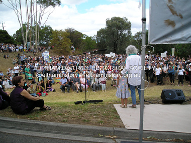
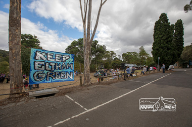
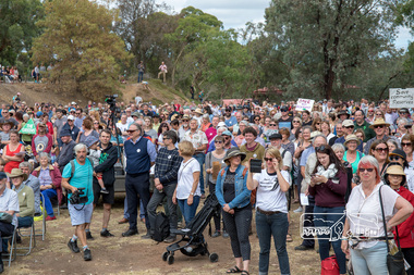
Photograph, Members of the community gather on the site of the former Shire of Eltham offices, Save Community Reserves Rally, Main Road, Eltham, 4 March 2018, 4/3/2018
... Shire of Eltham offices, Save Community Reserves Rally, Main...parks ...Protest rally against Nillumbik Shire Councillors' proposal to sell off 17 community reserves. Held at the site of the former Shire of Eltham offices, at 895 Main Road, which were demolished in August 1996, followed by a march along Main Road finishing at the Eltham Railway Station car park at Luck Street. Estimated attendance was approximately 3,000.Born digital image (8)nillumbik shire council, parks, save community reserves, protest rally -
 Eltham District Historical Society Inc
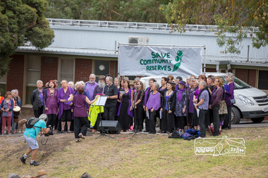
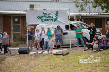
Photograph, The Chocolate Lilies Choir kick off the entertainment, Save Community Reserves Rally, Main Road, Eltham, 4 March 2018, 4/3/2018
... Community Reserves Rally, Main Road, Eltham, 4 March 2018...parks ...Protest rally against Nillumbik Shire Councillors' proposal to sell off 17 community reserves. Held at the site of the former Shire of Eltham offices, at 895 Main Road, which were demolished in August 1996, followed by a march along Main Road finishing at the Eltham Railway Station car park at Luck Street. Estimated attendance was approximately 3,000.Born digital image (15)nillumbik shire council, parks, save community reserves, protest rally -
 Eltham District Historical Society Inc
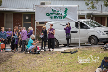
Photograph, Nerida Kirov, one of the rally organisers, addresses the crowd, Save Community Reserves Rally, Main Road, Eltham, 4 March 2018, 4/3/2018
... crowd, Save Community Reserves Rally, Main Road, Eltham, 4 March...parks ...Protest rally against Nillumbik Shire Councillors' proposal to sell off 17 community reserves. Held at the site of the former Shire of Eltham offices, at 895 Main Road, which were demolished in August 1996, followed by a march along Main Road finishing at the Eltham Railway Station car park at Luck Street. Estimated attendance was approximately 3,000.Born digital image (16)nillumbik shire council, parks, save community reserves, protest rally -
 Eltham District Historical Society Inc
Photograph, Sarah Krug, one of the rally organisers from Save Community Reserves, addresses the crowd, Save Community Reserves Rally, Main Road, Eltham, 4 March 2018, 4/3/2018
... Reserves, addresses the crowd, Save Community Reserves Rally, Main...parks ...Protest rally against Nillumbik Shire Councillors' proposal to sell off 17 community reserves. Held at the site of the former Shire of Eltham offices, at 895 Main Road, which were demolished in August 1996, followed by a march along Main Road finishing at the Eltham Railway Station car park at Luck Street. Estimated attendance was approximately 3,000.Born digital image (10)nillumbik shire council, parks, save community reserves, protest rally -
 Eltham District Historical Society Inc
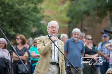
Photograph, Historian, Andrew Lemon addresses the crowd, Save Community Reserves Rally, Main Road, Eltham, 4 March 2018, 4/3/2018
... Reserves Rally, Main Road, Eltham, 4 March 2018...parks ...Protest rally against Nillumbik Shire Councillors' proposal to sell off 17 community reserves. Held at the site of the former Shire of Eltham offices, at 895 Main Road, which were demolished in August 1996, followed by a march along Main Road finishing at the Eltham Railway Station car park at Luck Street. Estimated attendance was approximately 3,000.Born digital image (13)nillumbik shire council, parks, save community reserves, protest rally -
 Eltham District Historical Society Inc
Photograph, Former Mayor, Margaret Jennings addresses the crowd, Save Community Reserves Rally, Main Road, Eltham, 4 March 2018, 4/3/2018
... Community Reserves Rally, Main Road, Eltham, 4 March 2018...parks ...Protest rally against Nillumbik Shire Councillors' proposal to sell off 17 community reserves. Held at the site of the former Shire of Eltham offices, at 895 Main Road, which were demolished in August 1996, followed by a march along Main Road finishing at the Eltham Railway Station car park at Luck Street. Estimated attendance was approximately 3,000.Born digital image (8)nillumbik shire council, parks, save community reserves, protest rally -
 Eltham District Historical Society Inc
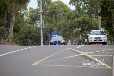
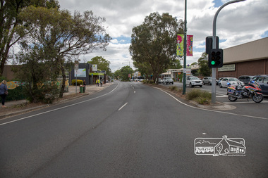
Photograph, Main Road north bound closed and secured by Police, Save Community Reserves Rally, Main Road, Eltham, 4 March 2018, 4/3/2018
... Community Reserves Rally, Main Road, Eltham, 4 March 2018...parks ...Protest rally against Nillumbik Shire Councillors' proposal to sell off 17 community reserves. Held at the site of the former Shire of Eltham offices, at 895 Main Road, which were demolished in August 1996, followed by a march along Main Road finishing at the Eltham Railway Station car park at Luck Street. Estimated attendance was approximately 3,000.Born digital image (4)nillumbik shire council, parks, save community reserves, protest rally -
 Eltham District Historical Society Inc
Photograph, Greg Champion entertains the crowd, Save Community Reserves Rally, Main Road, Eltham, 4 March 2018, 4/3/2018
... Greg Champion entertains the crowd, Save Community Reserves...parks ...Protest rally against Nillumbik Shire Councillors' proposal to sell off 17 community reserves. Held at the site of the former Shire of Eltham offices, at 895 Main Road, which were demolished in August 1996, followed by a march along Main Road finishing at the Eltham Railway Station car park at Luck Street. Estimated attendance was approximately 3,000.Born digital image (19)nillumbik shire council, parks, save community reserves, protest rally -
 Eltham District Historical Society Inc
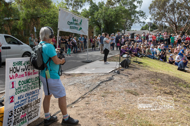
Photograph, Getting ready for the crowd about to march down Main Road, Save Community Reserves Rally, Main Road, Eltham, 4 March 2018, 4/3/2018
... , Save Community Reserves Rally, Main Road, Eltham, 4 March 2018...parks ...Protest rally against Nillumbik Shire Councillors' proposal to sell off 17 community reserves. Held at the site of the former Shire of Eltham offices, at 895 Main Road, which were demolished in August 1996, followed by a march along Main Road finishing at the Eltham Railway Station car park at Luck Street. Estimated attendance was approximately 3,000.Born digital image (3)nillumbik shire council, parks, save community reserves, protest rally -
 Eltham District Historical Society Inc
Photograph, The march down Main Road commences, Save Community Reserves Rally, Main Road, Eltham, 4 March 2018, 4/3/2018
... The march down Main Road commences, Save Community Reserves...parks ...Protest rally against Nillumbik Shire Councillors' proposal to sell off 17 community reserves. Held at the site of the former Shire of Eltham offices, at 895 Main Road, which were demolished in August 1996, followed by a march along Main Road finishing at the Eltham Railway Station car park at Luck Street. Estimated attendance was approximately 3,000.Born digital image (3)nillumbik shire council, parks, save community reserves, protest rally -
 Eltham District Historical Society Inc
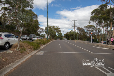
Photograph, An empty Main Road looking north, Save Community Reserves Rally, Main Road, Eltham, 4 March 2018, 4/3/2018
... An empty Main Road looking north, Save Community Reserves...parks ...Protest rally against Nillumbik Shire Councillors' proposal to sell off 17 community reserves. Held at the site of the former Shire of Eltham offices, at 895 Main Road, which were demolished in August 1996, followed by a march along Main Road finishing at the Eltham Railway Station car park at Luck Street. Estimated attendance was approximately 3,000.Born digital image (3)nillumbik shire council, parks, save community reserves, protest rally