Showing 189 items matching "parks wide"
-
 Kew Historical Society Inc
Photograph - 'Fernhurst', 13 Fernhurst Grove, 1978
George Wharton arrived in Melbourne in 1844. An architect and surveyor, he was appointed to lay out the 'Village of Kew' by N.A. Fenwick following the land sales of 1851. A protagonist for Kew's separation from the Boroondara District Road Board, he was elected chairman when Kew achieved municipal status in December 1860. His home, 'Fernhurst', was built in 1866 on eight acres in Studley Park, with a four-storey tower and pyramidal roof. The Italianate home was a prominent Kew landmark. It was demolished in 1979 and replaced by St Paul's College in 1980.Rare colour photograph of what was once a significant mansion in Kew.Original colour positive photograph (Kodak print) of 'Fernhurst' in 1978. Photographed by Stewart West in May 1978, one year before it was demolished, the photograph gives little idea of the large landholding once surrounding the house. Originally accessed from near the corner of Princess Street and Studley Park Road, its gardens had been subdivided in the 1900s and its footprint restricted to 13 Fernhurst Grove. Like many other grand houses, by the 1970s it had been converted into apartments. From the photograph, one can see that the house had retained many of its original features such as the distinctive tower and the wide bow-fronted verandah. The slates on the roof (apart from those on the tower) had been replaced by tiles and the cement render of the exterior painted white. Annotated reverse: "Back view of Fernhurst / 8"fernhurst, 13 fernhurst grove -- kew (vic.), george wharton, italianate architecture, vila maria society, st paul's school for the blind -
 Kew Historical Society Inc
Photograph - 'Fernhurst', 13 Fernhurst Grove, 1978
George Wharton arrived in Melbourne in 1844. An architect and surveyor, he was appointed to lay out the 'Village of Kew' by N.A. Fenwick following the land sales of 1851. A protagonist for Kew's separation from the Boroondara District Road Board, he was elected chairman when Kew achieved municipal status in December 1860. His home, 'Fernhurst', was built in 1866 on eight acres in Studley Park, with a four-storey tower and pyramidal roof. The Italianate home was a prominent Kew landmark. It was demolished in 1979 and replaced by St Paul's College in 1980.Rare colour photograph of what was once a significant mansion in Kew.Original colour positive photograph (Kodak print) of 'Fernhurst' in 1978. Photographed by Stewart West in May 1978, one year before it was demolished, the photograph gives little idea of the large landholding once surrounding the house. Originally accessed from near the corner of Princess Street and Studley Park Road, its gardens had been subdivided in the 1900s and its footprint restricted to 13 Fernhurst Grove. Like many other grand houses, by the 1970s it had been converted into apartments. From the photograph, one can see that the house had retained many of its original features such as the distinctive tower and the wide bow-fronted verandah. The slates on the roof (apart from those on the tower) had been replaced by tiles and the cement render of the exterior painted white. Annotated reverse: "Fernhurst front view taken from across Fernhurst Grove / 6"fernhurst, 13 fernhurst grove -- kew (vic.), george wharton, italianate architecture, vila maria society, st paul's school for the blind -
 Kew Historical Society Inc
Photograph - 'Fernhurst', 13 Fernhurst Grove, 1978
George Wharton arrived in Melbourne in 1844. An architect and surveyor, he was appointed to lay out the 'Village of Kew' by N.A. Fenwick following the land sales of 1851. A protagonist for Kew's separation from the Boroondara District Road Board, he was elected chairman when Kew achieved municipal status in December 1860. His home, 'Fernhurst', was built in 1866 on eight acres in Studley Park, with a four-storey tower and pyramidal roof. The Italianate home was a prominent Kew landmark. It was demolished in 1979 and replaced by St Paul's College in 1980.Rare colour photograph of what was once a significant mansion in Kew.Original colour positive photograph (Kodak print) of 'Fernhurst' in 1978. Photographed by Stewart West in May 1978, one year before it was demolished, the photograph gives little idea of the large landholding once surrounding the house. Originally accessed from near the corner of Princess Street and Studley Park Road, its gardens had been subdivided in the 1900s and its footprint restricted to 13 Fernhurst Grove. Like many other grand houses, by the 1970s it had been converted into apartments. From the photograph, one can see that the house had retained many of its original features such as the distinctive tower and the wide bow-fronted verandah. The slates on the roof (apart from those on the tower) had been replaced by tiles and the cement render of the exterior painted white. Annotated reverse: "Front view of Fernhurst showing tower to advantage / 9"fernhurst, 13 fernhurst grove -- kew (vic.), george wharton, italianate architecture, vila maria society, st paul's school for the blind -
 Kew Historical Society Inc
Photograph - 'Fernhurst', 13 Fernhurst Grove, 1978
George Wharton arrived in Melbourne in 1844. An architect and surveyor, he was appointed to lay out the 'Village of Kew' by N.A. Fenwick following the land sales of 1851. A protagonist for Kew's separation from the Boroondara District Road Board, he was elected chairman when Kew achieved municipal status in December 1860. His home, 'Fernhurst', was built in 1866 on eight acres in Studley Park, with a four-storey tower and pyramidal roof. The Italianate home was a prominent Kew landmark. It was demolished in 1979 and replaced by St Paul's College in 1980.Rare colour photograph of what was once a significant mansion in Kew.Original colour positive photograph (Kodak print) of 'Fernhurst' in 1978. Photographed by Stewart West in May 1978, one year before it was demolished, the photograph gives little idea of the large landholding once surrounding the house. Originally accessed from near the corner of Princess Street and Studley Park Road, its gardens had been subdivided in the 1900s and its footprint restricted to 13 Fernhurst Grove. Like many other grand houses, by the 1970s it had been converted into apartments. From the photograph, one can see that the house had retained many of its original features such as the distinctive tower and the wide bow-fronted verandah. The slates on the roof (apart from those on the tower) had been replaced by tiles and the cement render of the exterior painted white. Annotated reverse: "Fernhurst corner shot through trees / 12-22"fernhurst, 13 fernhurst grove -- kew (vic.), george wharton, italianate architecture, vila maria society, st paul's school for the blind -
![Studley Park [Toll] Bridge, Kew](/media/collectors/550653872162f11fb04854aa/items/579ebf04d0cdd117c4c0815f/item-media/579ebf3ad0cdd117c4c0953e/item-fit-380x285.jpg) Kew Historical Society Inc
Kew Historical Society IncPhotograph, Studley Park [Toll] Bridge, Kew, 1870s
‘Studley Park Bridge’ or ‘penny bridge’ linked Church Street in Abbotsford and what is now Yarra Bend Park. The privately constructed bridge opened in 1857, gaining its popular name from the toll charged at the Abbotsford end. The engineer of the 485ft wide bridge was Mr. Austin and the builder was ‘Mr Grant, who threw the bridge over the Niagara’. Following the opening of Johnston Street Bridge, declining tolls led to the Bridge falling into disrepair. Badly damaged by the flood of 1891, the Bridge was compulsorily acquired by the Government in 1899, and later dismantled and sold for firewood.This work forms part of the collection assembled by the historian Dorothy Rogers, that was donated to the Kew Historical Society by her son John Rogers in 2015. The manuscripts, photographs, maps, and documents were sourced by her from both family and local collections or produced as references for her print publications. Many were directly used by Rogers in writing ‘Lovely Old Homes of Kew’ (1961) and 'A History of Kew' (1973), or the numerous articles on local history that she produced for suburban newspapers. Most of the photographs in the collection include detailed annotations in her hand. The Rogers Collection provides a comprehensive insight into the working habits of a historian in the 1960s and 1970s. Together it forms the largest privately-donated collection within the archives of the Kew Historical Society.A print, taken in the 1960s by Dorothy Rogers, from an original albumen silver photograph now in the collection of the Kew Historical Society. The photograph shows the toll bridge (also known as the Penny Bridge) from the northern end."P[enny] Toll Bridge - built 1857. from old photo"studley park bridge, penny bridge, bridge, timber bridge, toll bridge -
 Kew Historical Society Inc
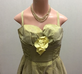
Clothing - Shot Silk Dance Frock & Wrap, Park Avenue Gowns, c.1960
The Fashion & Design collection of the Kew Historical Society includes examples of women’s, men’s, children’s and infants’ clothing from the 18th, 19th and 20th centuries. Items in the collection were largely produced for, or purchased by women in Melbourne, and includes examples of outerwear, protective wear, nightwear, underwear and costume accessories.This 'dance frock' by Park Avenue Gowns is one of a number of garments in the collection by this designer.Metallic thread silk cocktail dress and wrap by Park Avenue Gowns, 1960. Virtually identical dresses by the designer were featured in the Australian Women's Weekly in 1960, described as 'dance frocks', to which the wide flairing skirt would be well suited.Label : "Park Avenue Gowns"women's clothing, cocktail dresses, dance frocks, australian fashion - 1960s, fashion designers - melbourne (vic) - park avenue gowns -
 Glen Eira City Council History and Heritage Collection
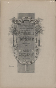
Booklet, "AVENUES OF HONOUR The Councils of the Municipalities of the CITY OF CAULFIELD TOWN OF BRIGHTON acting in conjunction PUBLIC DEMONSTRATION SAT 3rd AUG. 1918 AT 3oCLOCK"
Souvenir Programme from the Councils of the Municipalities of the City of Caulfield and the Town of Brighton for a Public Demonstration to be held on Sat 3rd August 1918 at 3 o'clock for the proposed Avenues of Honour to be planted in memory of fallen WWI soldiers. From Honour Roll Display 2019 interpretation panel - Brighton-Caulfield Avenue of Honour It is hard to imagine but a grand arboreal Avenue of Honour once lined parts of North Road, McMillan Street and Point Nepean Road (now Nepean Highway). The Avenue of Honour was a distinctly Australian phenomenon with hundreds being constructed throughout Australia during and following World War One, most of these in Victoria. Consisting of tree lined streets with each tree representing a solider, the Avenue of Honour signalled a more egalitarian approach to commemoration where rank was not a consideration. Arguably the most famous Avenue of Honour in Victoria still exists at Ballarat. Stretching for nearly 22 kilometres, the entrance to the Avenue is marked by the imposing Arch of Victory. Smaller in scale, the Brighton-Caulfield Avenue of Honour was dedicated to the ‘memory of (Brighton and Caulfield’s) kith and kin who came from (the) district and who died in the Great War’. A joint project between the neighbouring Councils, the idea was first reported in The Argus on 1 July 1918. Plans moved along quickly and on 3 August 1918 the Governor of Victoria Arthur Stanley planted the first Australian flowering gum. The next of kin were then invited to plant trees for lost sons, brothers, uncles, nephews and husbands. In all, over 400 trees were planted. Intensely personal, the Avenue also acted as a focus of grief and remembrance for the wider community. For many years, the annual civic Anzac Day service was held at the Avenue on Point Nepean Road, near Glen Huntly Road, Elsternwick. The service was moved to Caulfield Park upon the completion of the Cenotaph in 1930. Due to road widening and disease the last original tree was replaced in the 1980s, however a plaque in Caulfield Park records the Avenue’s plantation. Commemorative booklet, grey cover with text printed on the grey textured paper cover and an image of four trees and a wreath. Image of a kookaburra on the back. Inside, 28 numbered pages with b/w text and photographic images including a transparent paper representation of the proposed Avenues of Honour on Brighton Road and Point Nepean Road. Souvenir programme for a Public Demonstration for the Avenues of Honour as detailed on the front.city of caufield, world war one, first world war, anzac, remembrance, town of brighton, brighton, caulfield, avenue of honour -
 Glen Eira City Council History and Heritage Collection
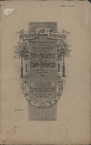
Booklet, D. W. Paterson Co. Pty. Ltd, "AVENUES OF HONOUR The Councils of the Municipalities of the CITY OF CAULFIELD TOWN OF BRIGHTON acting in conjunction PUBLIC DEMONSTRATION SAT 3rd AUG. 1918 AT 3oCLOCK SOUVENIR"
Souvenir Programme from the Councils of the Municipalities of the City of Caulfield and the Town of Brighton for a Public Demonstration to be held on Sat 3rd August 1918 at 3 o'clock for the proposed Avenues of Honour to be planted in memory of fallen WWI soldiers. One of two known copies, this copy has "Town Clerk" stamped in the upper corner, rhs.Commemorative booklet, grey cover with text printed on the grey textured paper and an image of four trees and a wreath. Image of a kookaburra on the back. Inside, 28 numbered pages with b/w text and photographic images including a transparent paper representation of the proposed Avenues of Honour on Brighton Road and Point Nepean Road. Souvenir programme for a Public Demonstration for the Avenues of Honour as detailed on the front. From Honour Roll Display 2019 interpretation panel - Brighton-Caulfield Avenue of Honour It is hard to imagine but a grand arboreal Avenue of Honour once lined parts of North Road, McMillan Street and Point Nepean Road (now Nepean Highway). The Avenue of Honour was a distinctly Australian phenomenon with hundreds being constructed throughout Australia during and following World War One, most of these in Victoria. Consisting of tree lined streets with each tree representing a solider, the Avenue of Honour signalled a more egalitarian approach to commemoration where rank was not a consideration. Arguably the most famous Avenue of Honour in Victoria still exists at Ballarat. Stretching for nearly 22 kilometres, the entrance to the Avenue is marked by the imposing Arch of Victory. Smaller in scale, the Brighton-Caulfield Avenue of Honour was dedicated to the ‘memory of (Brighton and Caulfield’s) kith and kin who came from (the) district and who died in the Great War’. A joint project between the neighbouring Councils, the idea was first reported in The Argus on 1 July 1918. Plans moved along quickly and on 3 August 1918 the Governor of Victoria Arthur Stanley planted the first Australian flowering gum. The next of kin were then invited to plant trees for lost sons, brothers, uncles, nephews and husbands. In all, over 400 trees were planted. Intensely personal, the Avenue also acted as a focus of grief and remembrance for the wider community. For many years, the annual civic Anzac Day service was held at the Avenue on Point Nepean Road, near Glen Huntly Road, Elsternwick. The service was moved to Caulfield Park upon the completion of the Cenotaph in 1930. Due to road widening and disease the last original tree was replaced in the 1980s, however a plaque in Caulfield Park records the Avenue’s plantation. Inkstamp upper corner rhs: "TOWN CLERK" -
 Surrey Hills Historical Society Collection
Photograph, 17 Essex Road, Surrey Hills
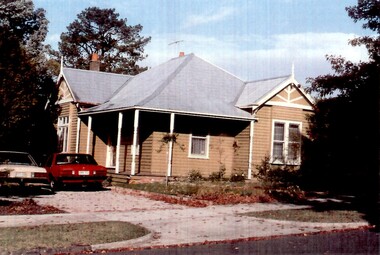
An Edwardian style timber house with a galvanised iron roof on a wide block. It is painted in a mid-brown with white trim to the windows, gables, finials and veranda posts. The veranda is timber with 6 turned posts. The front door is accessed from the side off the driveway in which are parked 2 (?) Ford falcons, one cream-coloured and the other red. -
 Federation University Art Collection
Artwork, other - Artwork, "West Park Proposition' by Ash Keating, 2013
Ash KEATING Among fifteen finalists this artwork won the 2012 Guirguis New Art Prize, a prestigious national acquisitive biennial art prize administered by Federation University Australia. The Guirguis New Art Prize (GNAP) is a national acquisitive $20,000 contemporary art prize which presents a selection of Australia's most exciting contemporary artists with works that explore and embrace new ways of artistic expression, utilising existing mediums and new technologies in innovative ways. Initiated and generously supported by local Ballarat surgeon Mr Mark Guirguis, this prestigious art prize is administered by the Federation University Australia (FedUni). As a local philanthropist and art collector, in developing the Prize, Mark Guirguis' aims were to celebrate the significance of the arts to communities and to Ballarat, emphasising contemporary art and 'living' culture, and to highlight FedUni's Arts Academy. Artist Ash Keating works across a conceptual, site-responsive and often collaborative art practice that incorporates painting, sculpture, installation, video, performance and public interventions, and has referenced a wide range of social and environmental issues within his art. Frequently working beyond the gallery, and often harnessing community narrative and energy, his work also draws upon myth, ritual and ceremony. 'West Park Proposition', 2012, is a three channel and screen video installation, utilising multiple camera video documentation of an endurance painting intervention undertaken on the morning of 01 September 2012 on the east facing wall of a newly built tilt-slab industrial building, situated on the direct edge of the current urban and rural boundary in Truganina, Victoria. The multi-screen work documents an endurance guerilla-style action painting intervention and ritualised painting performance in which a symbolic violence is enacted against a storehouse of commodity production and consumption. Upon winning the award artists Ash Keating said; “The work was made near Ballarat on the Deer Park bypass. It is an aesthetic comment about the way these new tilt-slab industrial buildings spring up without caring for the environment." The work, which took eight hours to create, was about reclaiming the space from “cost-effective architecture” without any aesthetics. The inaugural judge for the Prize, Jason Smith, Director, Heide Museum of Modern Art (MoMA) said, "Selecting the winner of this inaugural GNAP was exhilarating and excruciating: exhilarating because the seriousness of each artist's enterprise, and their uncompromising resolution of concepts, has created an inaugural exhibition of exceptional power. This first GNAP is a survey of some of the most poetic and provocative imaginations working in Australia today. Selecting one winner from such a show in which each of these artists has in some way transformed my thinking about the world was the excruciating part. Ash Keating's work West Park Proposition, 2012 kept drawing me back in the several hours I spent viewing the works. It simultaneously affirms the political and critical role of the artist as a key agent of change and action, and someone who reminds us of the beauty and resilience of humanity and nature in the face of unrelenting change. As a work combining performance, collaboration and hope, Keating's West Park Proposition is a work of immense and compelling poetry."artist, artwork, keating, ash keating, guirguis, guirguis new art prize, gnap, gnap13 -
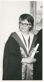 Royal District Nursing Service (now known as Bolton Clarke)
Photograph - Photograph, black and white, Barry Sutton, 13 07 1971
The photograph was taken in the Board Room of Royal District Nursing Service (RDNS) 452 St. Kilda Road, Melbourne. It was taken after Sister Pat (Paddy) Rowley received her Fellowship of the Australian College of Nursing. The Australian College of Nursing describes the Fellowship as follows: "Fellowship of the Australian College of Nursing (ACN), is a prestigious member status awarded to nurses in recognition of significant professional achievement. Fellowship recognizes the experience and contribution of nurse leaders to ACN and the profession".The regalia worn by Sr. Rowley as a Fellow, is a black gown with the wide trim to the front edges of scarlet satin and the regalia hood of inner white and outer scarlet satin. Sr. Rowley is the Principal Nurse Educator at RDNS.Sister Rowley commenced at Melbourne District Nursing Society (MDNS) in 1956 working as a District Nurse in a large district covering South Melbourne, Albert Park, Middle Park, and suburbs bordering from St. Kilda to Port Melbourne. In 1961 she was asked to be a Control Sister answering the telephones in Headquarters. She left MDNS for a short period, and after being asked to return was accepted, in August 1962 to take the MDNS 2nd Post Basic Course written by Miss Mary Evans; during this time Sr. Rowley wrote a paper on Liaison which led to continuity of care of patients between hospitals and RDNS. Following the course she commenced in Education and rewrote the Post Basic Course. In 1964 Sr. Rowley commenced, on a part time basis, working as a Liaison Officer at the Alfred Hospital. She attended the Teachers College, doing the 12 month course in 6 months, but this course did not have a health component, so she applied, and received, a Florence Nightingale Scholarship to the College of Nursing, gaining her Diploma of Nursing Education in 1968. Following this she became the, now named, Royal District Nursing Service (RDNS), Education Officer. In 1969 Sr. Rowley, with Miss Mary Evans, DON, attended the quadrennial Congress of the International Council of Nurses in Montreal, Canada and then Sr. Rowley visited USA looking at Public Health Nursing Education programs. As well as her RDNS work, Sr. Rowley became Nursing Consultant to the St. John's Ambulance Association in 1970, assisting in planning their Home Nursing Course book. In July 1971 Sister Pat (Paddy) Rowley, was awarded Fellowship of the Australian College of Nursing (ACN). The Australian College of Nursing describes the Fellowship as follows: "Fellowship of the Australian College of Nursing (ACN), is a prestigious member status awarded to nurses in recognition of significant professional achievement. Fellowship recognizes the experience and contribution of nurse leaders to ACN and the profession”. Sr. Rowley was then appointed as Principal Nurse Educator and wrote many of the programs for the Education department. Working as an Educator she travelled to regional hospitals, e.g. in Geelong and Ballarat to give lectures on District Nursing. When the Education Department relocated to 488 St. Kilda Road, she arranged the floor plan of the rooms. Sister Rowley retired from RDNS in 1988 having worked for 26 years in Education and a total of 32 years with the Melbourne, later named Royal, District Nursing Service. . Black and white photograph of a three quarter length view of Royal District Nursing Service (RDNS), Sister Pat (Paddy) Rowley. Sister Rowley, who has her head turned slightly toward the left of the photograph, is wearing dark rimmed glasses and has short dark straight hair. Over her light coloured top, she is wearing a black long open gown with wide trim, and regalia hood of white inner and dark outer satin. Her hands are clasped to the front holding a rolled white certificate held closed with a ribbon and bow. In the background the left edge of a framed landscape painting is seen on the wall. Part of Photographer stamp. Quote No. KJ 57royal district nursing service, rdns, fellowship of the acn, melbourne district nursing service, sister pat (paddy) rowley -
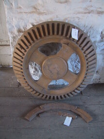 Parks Victoria - Andersons Mill
Tool - Pattern, wooden
Used as pattern to cast crown wheel of drive on water wheel. Actual drive has since been sold, only mold remainsCircular wooden pattern, raised centre circular area surrounded by four wide, flat spokes at regular intervals (the interim spaces being cut out with rounded corners) which are in turn surrounded by a rim which tapers back from the centre of the piece and has fixed to it regularly interleaved slats. Slats of protruding oblongs tapered from attachment to top and also central end to outer point. Light coloured wood 1 & 2 are Broken off pieces of back. -
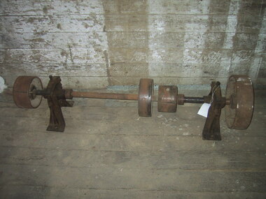 Parks Victoria - Andersons Mill
Equipment - Drive shaft
Probably used to drive machinery as part of milling process.From left to right along long centre pole (horizontal) is a small wide wheel, on a narrow arched stand.At the centre of the pole is a larger, slimmer wheel followed by a smaller wheel. -
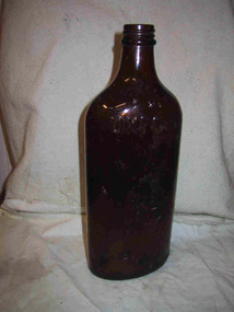 Parks Victoria - Gabo Island Lightstation
Bottle
Found on Gabo Island. The screw top bottle is the property of Nugget Polish P/L, Oxford brand shoe polish. The firm, which was a branch of the London firm, Nugget Polish Co., was located at 16-20 Kanowna Street, Williamstown from 1909. The age of the bottle is unknown.Brown glass bottle, long body, short neck for screw top. Wide at front curved to narrow sides.On front"OXFORD / THE PROPERTY OF NUGGET POLISH PTY. LTD" -
 Parks Victoria - Gabo Island Lightstation
Lens section
Detached sector panel from upper lantern. The lens segment is one of a pair of freestanding panels that formerly stood on a platform in the upper lantern room on either side of a small fixed light. The platform rested above the 1860/62 Chance Bros. first order, fixed lens and could be accessed by a ladder. The two sector lens panels were each set in a bronze frame and comprised a curved wider (belt) piece in the centre with nine curved, slim line pieces above and below it (19 pieces in total). The belt aligned with the light source to provide optimal focus and range. The panels, the light and the platform were installed in 1934 to upgrade the original optical system with red warning lights. Fitting them above the lantern was a convenient and inexpensive way to do this, with each lens panel set up behind a red glass panel to project a red sector to the seaward over to Cape Howe and the Western Shore. The two sectors are likely to be Chance Bros. by manufacture although they do not appear to bear the maker’s name. This is probably because Chance Bros. typically fixed metal plaques to their apparatus and tended not to stamp smaller components such as their lens frames. It could possibly indicate that the two sectors are former components of a larger system, i.e. another lens. This can easily be confirmed by closely inspecting the bronze frames. A series of holes on the frame would indicate that ‘they would have bolted to other panels to make a larger lens assembly’. The absence of holes would confirm that ‘they were made specifically to stand alone’. The sector panels were removed from the Gabo lantern in February 1992. At some point after their removal, they were found in boxes marked with ‘Ince Pt.’, however it is thought that Ince Point lighthouse ‘never had … stand alone sectors’. The panel in the Gabo Island collection is one of two segments discovered at the Eden Killer Whale Museum in about 2007. One section was repatriated to Gabo Island and the other was to go to Smoky Cape Lighthouse in northern NSW. The Gabo lens segment has first level contributory significance for its historic value and provenance to the lantern room. It is recommended that Parks Victoria/AMSA seek to return the Smoky Cape segment to Gabo Island and reunite the sector panels.The Gabo lens segment has first level contributory significance for its historic value and provenance to the lantern room.Section of a lens from a lighting apparatus , rectangular louvers of glass enclosed in a metal frame. -
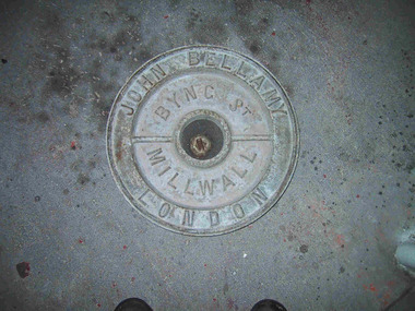 Parks Victoria - Point Hicks Lightstation
Lid, ship tank
The heavy cast iron, round lid was originally fastened into a large, riveted metal box, known as a ship tank. It has the name ‘John Bellamy London’ cast in capitals in a continuous circle on the outer edge of the lid face, and the words ‘Byng St Millwall’ on the inner circle. , of Millwall, London, manufactured boilers and ship tanks from the 1860s to the 1930s and came from a family of tank makers who began manufacturing tanks some time before 1856. Ship tanks were invented in 1808 by notable engineer, Richard Trevithick and his associate John Dickinson. Their patent obtained the same year described the tank’s superior cubic shape that allowed it to fit squarely as a container in vessels and thus use space efficiently, while its metal fabric preserved and secured its liquid or solid contents from damage. The containers revolutionised the movement of goods by ship and made wooden casks redundant. Research by Michael Pearson has determined that they were carried on passages to Australia from at least the 1830s conveying ships’ victuals and water storage, as well as general goods heading for the colonies. Pearson found photographic evidence of their use in the 1860s, and by the 1870s they appeared to be in common use. lids surviving from containers indicate that nearly all the tanks transported to Australia came from London manufacturers. It was usual for the brand name to also feature as a stencil on the tank but in most cases this eventually wore off. A tank without its original stencil survives at Wilsons Promontory. Tanks transporting ‘drinking water or perishable dry goods were hermetically sealed by the use of the tightly fitting lid with a rubber sealing ring ‘which was screwed tight with the aid of lugs cast into the lid and wedges cast into the rim of the loading hole’. The raised iron rod welded across the outer face of many lids such as the Bellamy example, allowed for screwing the lid tight. Once in the colonies, the ship tanks were often recycled and adapted for many resourceful uses such as packing cases, dog kennels, water tanks, oil containers and food stores and this invariably led to the separation of the lid and tank. The Bellamy lid could have been salvaged from a shipwreck but is more likely to have to have originated from a recycled tank that was brought to the lightstation for water storage purposes. Pearson writes that: Ship tanks show up at a wide range of sites, many of them isolated like lighthouses. They were, I think, usually taken there for the purposes they filled, usually water storage, as they were readily available, relatively light to transport, and probably very cheap to buy as second-hand goods containers. In rural areas they may have been scavenged for their new uses from local stores, to whom goods were delivered in them. Parks Victoria has identified five tank lids in the lightstation collections covered by this project. In addition to the Bellamy lid at Point Hicks, they include a Bow brand lid at Point Hicks and another at Cape Otway, unidentified lids at Cape Otway and Wilsons Promontory. Pearson and Miles Lewis have each recorded two versions of the Bellamy trade name on the lids; one being ‘John Bellamy Byng St. London’; the other, ‘John Bellamy Byng St. Millwall London’. The Point Hicks lid has the second version of the name, as do other examples in Victoria that Lewis has identified at Illawarra, Toorak; Warrock homestead, Casterton; Eeyeuk homestead, Terang; Ward’s Mill, Kyneton; and Boisdale homestead near Maffra, and in NSW at Ayrdale Park, Wolumla; and Bishop’s Lodge, Hay. Pearson’s list includes the same lids in NSW at Tumbarumba; the Quarantine Station, Sydney; Willandra Station; Bedervale, Braidwood; Gunnedah Museum; Walla Walla and Macquarie Island. The Point Hicks lid is currently stored in the lighthouse although it is unlikely that its use had any association with this building. The lid is in good condition and retains the central bung. Pearson notes that ‘surviving lids are far less numerous than the tanks themselves, presumably because the uses to which the tanks were put did not require the lid to be retained’.347 The Bellamy ship tank lid has first level contributory significance for its historic values. Circular cast-iron disc with raised outer ridge with inscription. It also has an inner depression with inscription. Two metal sections form handles over inner depression. Hole in middle of disc.Around perimeter of outer edge "JOHN BELLAMY LONDON" Around inner area "BYNG ST MILLWALL" -
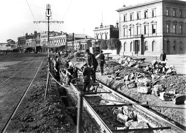 Ballarat Tramway Museum
Photograph - Geelong Tramway relaying stringer constructed track
Relaying stringer constructed track in Mercer St., just west of the Gheringhap St. intersection opposite Johnstone Park, looking east towards Malop Street. The southern track has subsided and the original concrete stringers dug out, with them lying beside the track. According to the local papers, wider stringers are to be used. August 1914.Black and white print on paper.GSR710/25/1/5, 25-5, and the no. 3 inside a circle, written in pencil on the reverse. The letter A, and the no. 1 in a circle are written in ink on the reverse.geelong tramway relaying tracks, geelong streetscape c. 1914 -
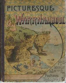 Warrnambool and District Historical Society Inc.
Book, Picturesque Warrnambool, 1891
This book presents a pictorial and written record of Warrnambool in 1891.It covers a wide range of topics. It provides statistical evidence relating to public buildings and organisations of that era, as well as basic information about district points of interest. The Mechanics Institute, the Common, Albert Park, the rivers, the Museum and the Sea Baths are all mentioned. The various drawings and advertisements provide a list of businesses which were prevalent at the time. As this book is one of only two complete copies documented to be still in existence, it is of considerable significance and importance to our collection. The drawings and text are artistically very much of the era and are aesthetically pleasing. Cardboard cover with picture of people on beach in tones of yellow, pink and blue sitting within a circle. Dark purple cloth spine binding. Back cover has drawing of Western Hotel. Pages are not numbered and there are a number of coloured and black and white drawings. Title is in dark purple and Warrnambool is in pink and blue tonesOn front cover “The Mermaids Caves” 1896. 1891 written in pen beneath roman numerals on bottom of title page. List of numbers written down title page in black pen.warrnambool, picturesque warrnambool, warrnambool 1891,, warrnambool, warrnambool 1891 -
 Wooragee Landcare Group
Photograph, 28th April 2004
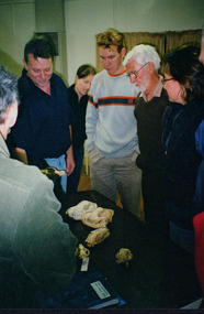
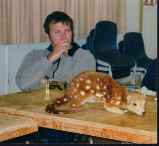
This photograph was taken at Wooragee Hall on Wednesday the 28th of April 2004 as part of an event called 'Queries about Quolls'. This event was hosted by the Wooragee Landcare Group and was led by Andrew Murray, President of the South East Forest Spotted-tailed Quoll Working Group and one of Victoria's leading authorities in quolls. As the name of the event would suggest, this session provided attendees with insight and general information on quolls, including the characteristics of quolls, the habitat of quolls and the techniques that can be used when searching for quolls. This event was likely part of a wider project aimed at protecting the endangered species of the tiger quoll, also known as the spotted-tailed quoll, an animal that once inhabited Mount Pilot-Chiltern National Park. The Tiger Quoll is the largest of the quoll species. Largely resembling a cross between a possum and a cat, the quoll is distinctive due to the white spots that are often found all over its brown fur. This photograph is significant as it provides evidence of a project undertaken by the Wooragee Landcare Group to educate members of the public on the tiger quoll in the early 2000s in an attempt to better understand and protect the species. The Wooragee Landcare Group has been instrumental in the co-ordination of programs relating to biodiversity protection in the local area, providing great assistance to landholders. Portrait coloured photograph printed on gloss paper.Reverse: WAN / NA / OANA2NO / NNN+ / 2 / 8743 / wooragee, wooragee hall, wooragee landcare, wooragee landcare group, quoll, spotted-tailed quoll, tiger quoll, queries about quolls, south east forest spotted-tailed quoll working group, andrew murray quolls, andy murray quolls, mount pilot chiltern national park, quoll species, endangered quoll -
 Wooragee Landcare Group
Photograph, 28th April 2004
This photograph was taken at Wooragee Hall on Wednesday the 28th of April 2004 as part of an event called 'Queries about Quolls'. This event was hosted by the Wooragee Landcare Group and was led by Andrew Murray, President of the South East Forest Spotted-tailed Quoll Working Group and one of Victoria's leading authorities in quolls. As the name of the event would suggest, this session provided attendees with insight and general information on quolls, including the characteristics of quolls, the habitat of quolls and the techniques that can be used when searching for quolls. This event was likely part of a wider project aimed at protecting the endangered species of the tiger quoll, also known as the spotted-tailed quoll, an animal that once inhabited Mount Pilot-Chiltern National Park. The Tiger Quoll is the largest of the quoll species. Largely resembling a cross between a possum and a cat, the quoll is distinctive due to the white spots that are often found all over its brown fur.This photograph is significant as it provides evidence of a project undertaken by the Wooragee Landcare Group to educate members of the public on the tiger quoll in the early 2000s in an attempt to better understand and protect the species. The Wooragee Landcare Group has been instrumental in the co-ordination of programs relating to biodiversity protection in the local area, providing great assistance to landholders.Square coloured photograph printed on gloss paper. Reverse: + 3 8748 / 265 wooragee, wooragee hall, wooragee landcare, wooragee landcare group, quoll, spotted-tailed quoll, tiger quoll, queries about quolls, south east forest spotted-tailed quoll working group, andrew murray quolls, andy murray quolls, mount pilot chiltern national park, quoll species, endangered quoll -
 Eltham District Historical Society Inc
Photograph - Digital Photograph, Marguerite Marshall, Eltham Lower Park, 20 April 2008
Originally a race course, the park has brought the community together with a variety of activities. Published: Nillumbik Now and Then / Marguerite Marshall 2008; photographs Alan King with Marguerite Marshall.; p45 Once used for horse racing, which attracted visitors from Melbourne, the Eltham Lower Park has brought the community together with a wide range of activities. Horse riding is now enjoyed as a recreation in the park as are other sports. The park also includes the Diamond Valley Railway miniature trains and a sanctuary for the rare and vulnerable Eltham Copper Butterfly. Eltham Lower Park, with other parks, forms an almost continuous green band from Eltham’s centre, along the Diamond Creek to the Yarra River.1 Before European settlement the Wurundjeri people met on this land, particularly at the junction of the Diamond Creek with the Yarra River, which they called Birr-arung. This is commemorated by the sculpture, Not just a Pretty Place by Aleks Danko, winner of the 2000 Nillumbik Art in Public Places Award. The first European to settle here was probably Henry Foley, who in 1841 used it as part of his pastoral run. Foley sold his leasehold to Joseph Wilson in 1845, who soon after sold it to Frederick Falkiner. During the 1840s the future park was part of a government square mile (2.6 sqkm) reserve, north of the Yarra, within the Parish of Nillumbik, later named Eltham. Soon the land was used for horse racing after nearby residents cleared ten acres (4ha) in the early 1850s. A three-quarter of a mile (1.2km) race secured the winner the £10 Publican’s Prize. In response to popular demand, the newly formed Eltham District Road Board petitioned the Surveyor General of the Colony of Victoria, in 1856, for 36 acres (14.6ha) of crown land for a racecourse and recreation. By 1858 the Eltham races had become an institution. ‘Many skirmishes occurred and the way home was paved with temptation, with sly-grog for sale.3 In the early 1870s, two jockeys were sons of the police officer in charge of the Eltham Police Station, Miles S Lyons. Another ten acres (4ha) was added to the area in 1866 and 12 acres (4.8ha) – Hohnes Hill – in 1870. In 1866, two acres (0.8ha) on the creek banks became an animal pound with William Walsh the pound keeper in 1870, but this was later incorporated into the park. By 1877 the area was called a public park but horse racing and training continued into the 1920s. In the mid-1900s trotters were trained on a circuit road. In 1953 the Eltham Pony Club was established and used a cross-country course on Hohnes Hill. From the mid 1950s the club held the Eltham Easter Fair at the park, later to include a procession along Main Road from the town centre to the park. The park also attracted picnic parties and campers from the inner suburbs as did Wingrove Park, and businesses catering for visitors, sprang up on the opposite side of Main Road. Bus-loads of school children visited the park for Gould League bird days in the 1960s. In 1979 the Eltham Shire Council bought Lenister Farm, linking the park with the Yarra River. The Lenister Farm wetland includes a bird hide, viewing platform and interpretive signs.5 Pioneer Henry Stooke, later Road Board chairman, bought the 11 acres (4.5ha) - later to become Lenister Farm - from the Crown in 1862. Stooke never lived on this site and the two houses at Lenister Farm were built in the 20th century. Since its formation in 1871, the Council has controlled this crown land, which it named Eltham Park. But in the 1920s Eltham Council bought land near the town centre for a park, which it named Eltham Central Park. To avoid confusion the Council renamed Eltham Park, Eltham Lower Park. Since 2004 the Yarra footbridge has linked the park with the Yarra Valley Metropolitan Park and the Main Yarra Trail.This collection of almost 130 photos about places and people within the Shire of Nillumbik, an urban and rural municipality in Melbourne's north, contributes to an understanding of the history of the Shire. Published in 2008 immediately prior to the Black Saturday bushfires of February 7, 2009, it documents sites that were impacted, and in some cases destroyed by the fires. It includes photographs taken especially for the publication, creating a unique time capsule representing the Shire in the early 21st century. It remains the most recent comprehenesive publication devoted to the Shire's history connecting local residents to the past. nillumbik now and then (marshall-king) collection, eltham lower park, eltham park -
 Falls Creek Historical Society
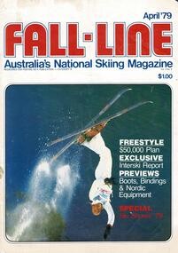
Magazine - Fall-Line - Australia's National Skiing Magazine April '79
“Fall-Line” was one of a series of magazines published by the Victorian Ski Association. It was produced from 1979 until 1985. It superseded their previous publication, “Ski” magazine and was followed by the “Australian Skiing” magazine. The Victorian Ski Association was formed in 1955.This magazine is significant because it documents developments in the ski industry in Australia.A magazine featuring a coloured image on the cover and containing articles and advertising related to developments in skiing in Australia. This issue included an update on improvements being made at Falls Creek. FALLS CREEK The chairlift access area near the medical centre, long famous as the Mudpie Parlour of Falls Creek, has been sealed and Falls Creek itself, the waters of which have filled many an unsuspecting gum- boot, has been bridged, also near the medical centre. A lock-up storage shed will be built along Bogong High Plains Road, just below the oversnow terminal, for the use and convenience of all village commercial operators and site holders. Direct access will be possible by snowmobile. Falls Creek rates have risen to $82.50 per bed (less 10% discount if paid on time). The rise is the first in two years, and is less than the corresponding rise in the C.P.I. over that period. The access trail from the water tanks at the base of the Home Trail to the nursery slope has been smoothed and widened to 12 metres, and a new six metre wide access trail has been cut from Falls Creek Road, just behind Diana lodge to the chairlift bottom station. The Village Bowl comfort station is being extended and renovated, and the finishing touches are being put on the comfort station in the upper car park. Construction of an akja station/toilet block in Sun Valley will commence in 1980. The Management Committee is investigating the purchase of a Mercedes 800 series snow-clearing machine to supplement the CRB equipment in use in village parking areas The village water supply has been re- designed to ensure adequate supply at all times.australian ski magazines, skiing australia, victorian ski association -
 Emerald Museum & Nobelius Heritage Park
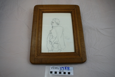
Sketch, "Spud" Dr. Ian S. McLeod Murphy
Dr. Murphy was a popular identity in Emerald and its surrounds. The sketch is significant because it gives a rough image of Dr. Murphy. After he died, a medical scholarship was created in his name for a young, local, first year undergraduate in Medicine. Pencil sketch on cartridge like paper, framed by a wide wooden frame"Spud". Dr Ian S. McLeod Murphy. D. Peterson 1974dr. murphy -
 Eltham District Historical Society Inc
Photograph, Alan Marshall, ca 1970
Portriats of Alan Marshall, and some with his secretary, Pat Wiltshire, at work in his Park Road, Eltham home and garden, c.1970 at the time he was writing "Pioneers and Painters". Alan Marshall, A.M., O.B.E., HON., LL. D. (1902-1984) was born at Noorat, Victoria and became one of Australia’s most famous authors. His association with the Eltham area began in 1920 when he started his first job as a junior clerk at the Eltham Shire Offices, Kangaroo Ground. In the 1940’s he spent sometime living in Research. From 1955 he lived in Eltham for nearly 20 years. Disabilities resulting from polio as a young child did not prevent a wide range of experiences. Alan’s occupations have been listed as clerk, night watchman, fortune teller, freelance journalist and author. He has been patron of many disadvantaged children’s societies. Alan’s books are numerous and include novel, short stories, children’s books, history and travel. Among the best known are his autobiographies “I can jump puddles” and “This is The Grass”. Others include “These are my people”, “Ourselves Writ Strange” and “Wild Red Horses”. In 1971 he wrote the centenary history of the Shire of Eltham, “Pioneers and Painters”. Black and white photographs of Alan Marshall at his home.pioneers and painters, alan marshall, pat wiltshire, park road -
 Eltham District Historical Society Inc
Photograph - Digital Photograph, Alan King, Alistair Knox Park, Eltham, 2008
Alistair Knox Park, an oasis of peace and beauty. Covered under National Trust of Australia (Victoria) Landscape Significance and Heritage Overlay, Nillumbik Planning Scheme. Published: Nillumbik Now and Then / Marguerite Marshall 2008; photographs Alan King with Marguerite Marshall.; p173 It is hard to imagine that the Alistair Knox Park, an oasis of peace and beauty beside busy Main Road, Eltham, was once the township’s rubbish dump. It was only in the 1970s that the tip was transformed into this beautiful six hectare space, which later earned it a National Trust Landscape classification. Before its life as a dump, the area was used for small farms. Thanks largely to the foresight and efforts of local environmental builder Alistair Knox, the park was designed sympathetically with the character of the wider Eltham landscape. Then, appropriately, the park was named after Knox, who was an Eltham Shire Councillor from 1971 to 1975 and Shire President in 1975. The park designers were four major forces in the urban bush landscape garden –Knox, landscape designer Gordon Ford, artist Peter Glass and landscaper Ivan Stranger. The National Trust citation for the park, originally called Eltham Town Park, includes the Eltham railway trestle bridge and the Shillinglaw Cottage. The citation states ‘the semi-natural setting of the parkland provides a landscape which is evocative of the history of the area’. Manna Gums (Eucalyptus viminalis) and Candlebarks (Eucalyptus rubida) are significant features. Most of the park’s construction was directed by Bob Grant, Superintendent of the Parks and Gardens Department for the Eltham Shire Council. First plantings occurred in Arbour Week in 1973, then the lake and botanic area were completed in 1975, with Federal Government funding, and the toilet block in 1978. Bounded by the Eltham railway line, Panther Place, Main Road, Bridge and Susan Streets, the park is in a valley about a kilometre wide overlooked by steep hills at the east and west. The Diamond Creek flows through it and the picturesque historic timber trestle railway bridge edges the north. Informal plantings of Australian indigenous and native species in open and undulating grassed settings blend with the natural landscape of the Diamond Creek to the west. The bush-style plants, particularly around the creek, balance with open lawns, paths and a cascade flowing from a small lake to another below. A footbridge over the creek leads to the park’s west. The park includes an adventure playground and barbecue areas. The park stands on part of the land bought from the Crown in 1851 by Josiah Holloway, who subdivided it into allotments and which he called Little Eltham. Most of the land was subdivided into residential lots, but the creek valley, on which the park stands, was subdivided into farm-size lots, used mainly for orchards and grazing. One of the earliest owners was John Hicks Petty, who in 1874 bought a plot from Holloway. Other families who owned properties in that area, included Rees, Clark, Waterfall, Graham, Hill and Morant. In 1901 the railway was built through the area. Jock Read, an Eltham resident since around 1920, remembers several farms in the 1920s and ’30s that occupied the site of today’s park. A poultry farm, which extended from present day Panther Place, was owned by the Gahan family. Next to that farm was another for grazing cattle owned by Jack Carrucan. Beside this was land owned by John Lyon. A doctor lived beside this, and at the north-west corner of Bridge Street and Main Road stood a memorial to the soldiers who died in World War One, which was later moved to the RSL site. Mr Read also remembers other farms and orchards west of the creek In the early 1960s the Eltham Council began buying these farms and in the late 1960s turned the areas east of the Diamond Creek into a garbage tip. When this was filled above the creek’s flood plain, the tip was moved to the west of the creek.This collection of almost 130 photos about places and people within the Shire of Nillumbik, an urban and rural municipality in Melbourne's north, contributes to an understanding of the history of the Shire. Published in 2008 immediately prior to the Black Saturday bushfires of February 7, 2009, it documents sites that were impacted, and in some cases destroyed by the fires. It includes photographs taken especially for the publication, creating a unique time capsule representing the Shire in the early 21st century. It remains the most recent comprehenesive publication devoted to the Shire's history connecting local residents to the past. nillumbik now and then (marshall-king) collection, alistair knox park, eltham -
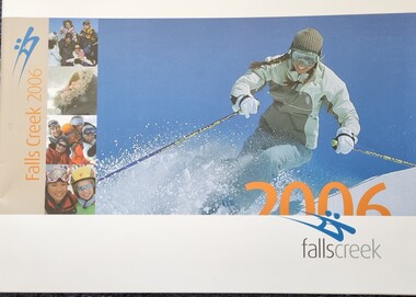 Falls Creek Historical Society
Booklet - Falls Creek Information 2006
Falls Creek 2006 included a wide range of new developments and activities. Some of these were Pete the Snow Dragon shows, Fox Trail, Women's Program, the Mouse Trap. Monkey Bar and Bungy Trampolining as well as night-time activities. The purchase of a Park Bully Kassbohrer snow groomer ensured an international standard freestyle terrain was maintained. The Falls Creek snowmaking system and snow farming also was given a huge boost with Wombats Ramble going on-line in 2006.This booklet is significant because it introduces a wide range of new activities and facilities at Falls Creek in 2006.A glossy publication of 48 pages promoting Falls Creek all year round. It includes detailed information of activities at Falls Creek, images and advertising.falls creek activities, snow grooming, snow making at falls creek -
 University of Melbourne, Burnley Campus Archives
Photograph - Black and white print, Principal's Residence, 1950
This is one of the best photographs of the Principal's ResidenceBlack and white photograph of the Principal's Residence, T.H. Kneen's Austin (B197) car parked at front entry. Identified by T.H. Kneen."3" wide" on reverseprincipal's residence, t.h. kneen, car, austin -
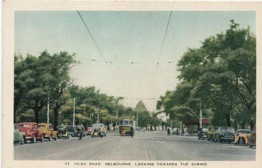 Melbourne Tram Museum
Postcard, Nu-color-Vue, "St Kilda Road, Melbourne looking towards the shrine", c mid 1950s
Postcard - colour titled "St Kilda Road, Melbourne looking towards the shrine". Has wide bodied tram in the distance and a number of vehicles, mostly parked, pedestrians and a shelter. On the rear - has a divided back, with details noting that the road has the capacity of 10 car lanes and twin tram lines. Produced by Nucolorview, using a genuine Kodachrome photographOn the rear has the stamp of Graeme S Breydon - see image i2.trams, tramways, melbourne, st kilda rd, shrine of remembrance, shelters -
 Melbourne Tram Museum
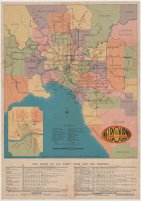
Ephemera - Map - Timetable, Melbourne & Metropolitan Tramways Board (MMTB), "Map and timetable of Melbourne Tram and Bus Services", March 1952
Map provided information about Melbourne's tramway network in 1952. At base of map - timetable of all night trams and bus services. On rear index to routes, 1st and last services, time of Sunday am services, Latrobe St. services and photo of Wattle Park. The conversion of Bourke St to electric trams marked up. Copy 1 - has been marked for hypothetical extensions in blue pencil mainly in the northern and western suburbs. In particular note the Ballarat Road and South Road markings. Copy 2 - has been marked up for newer route numbers, following the opening of the Bourke St services and additional route numbers on the Essendon Depot lines. Demonstrates the provision of information about Melbourne tram services.Fold out map (10 sections - 2 high x 5 wide), coloured of Melbourne's Tram and Bus routes, route numbers, rail lines, municipalities boundaries and location of major places of interest. melbourne, tram and bus services, mmtb, buses, trams, routes, timetables, all night services -
 Melbourne Tram Museum
Newspaper - Digital Image, The Age, establishment of a tram museum, 1991
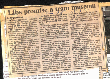
Set of 6 digital images of newspaper cuttings collected by Peter Hogan about the establishment of a tram museum, 75th Anniversary, Wattle Park and the PTC Open Day. Comprises, “Libs promise a tram museum” – The Age 25-11-91 – Quotes Mr. Brown, Photo from a magazine with a Hawthorn Horse tram at the Auburn Hotel – 75years of the HTT, “Tramways lines up 75th anniversary” – Progress Press 20-11-1991, about the planned cavalcade from Hawthorn Depot on Sunday, and a short history of the HTT, “Tram route extension plan is back on track” – Progress Press 16/10/1991. About the planned line to Box Hill, “Wattle Park” – article from the National Trust News of September 1991 with a two page article about the Wattle Park and its history., “State-wide Open Day” – Herald Sun 17/10/1991 about the planned open house by the Public Transport Corporation the following Sunday. Quotes Ian Stoney, PTC CEO. The four page supplement has been stapled together. See htd4574doc for a list of the file contents provided by Peter Hogan.trams, tramways, tram museum, wattle park, ptc, htt, 75th anniversary, horse trams, box hill