Showing 276 items matching "place names australia"
-
 Victorian Aboriginal Corporation for Languages
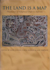
Book, Luise Hercus, The land is a map : placenames of Indigenous origin in Australia, 2002
Place names often evoke important information about features of the environment and their place in Indigenous knowledge. On the other hand, place names given by European settlers are largely arbitrary.Maps, b&w photographs, b&w illustrations, word listsplace names, wik, cape york peninsula, ngalakgan, alawa, marra, yukgul, kaurna, yuwaalaraay, yuwaaliyaay, gamilaraay, ngiyampaa -
 Victorian Aboriginal Corporation for Languages
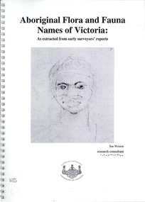
Book, Sue Wesson et al, Aboriginal flora and fauna names of Victoria : as extracted from early surveyors' reports, 2001
The Flora and Fauna Names Project is an initiative of the Victorian Aboriginal Corporation for Languages and the Victorian Biodiversity Strategy. The researcher has examined material from the archives of the Department of Natural Resources and Environment (NRE), the State Library of Victoria, the Victorian Public Records Office and the Australian Archives Office. This first stage of the project focussed on the NRE archives, in particular the field notebooks of the earliest surveyors and their maps although other NRE resources, libraries and public records were accessed. A total of 3028 words were found of which a significant proportion have previously been unknown to linguists. It appears that the place names and word lists in early surveyors notebooks, the 1858 surveyors responses to the Surveyor General and an extensive Wiradjuri wordlist by James Baylis have not yet been widely used or published. Fifteen percent of these 3028 words describe flora and fauna and six percent describe habitat. Of particular interest is the evidence provided by these lists of the existence of fauna in the mid nineteenth century in regions where it is now extinct. For example, magpie geese, eastern quolls, bustards and pademelons were assigned names in the Jardwadjali language area of the upper Glenelg and Wimmera Rivers. The outcomes of this project may help to assist in ascertaining the distribution of flora and fauna assets in Victoria.maps, b&w photographs, colour photographs, illustrations, word listswiradjuri, jardwadjali, glenelg river, wimmera river -
 Uniting Church Archives - Synod of Victoria
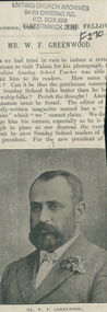
Newspaper cutting, Mr. W. F. Greenwood, 1899
The text reads as follows: "After we had tried in vain to induce a certain gentleman to visit Talma for his photograph, the Australian Sunday School Teacher was able to present him to its readers. How came t.. ..out? Can it be that the gentleman concered likes Sunday School folks better than he loves Fellowship folks? Perish the thought! Another explanation must be found. The editor of a …. …ghtly-written magazine named has "… ..d him" which "we" cannot claim. We do … …udge him his success, especially as he is (kind?) enough to place at our disposal the excellent portrait he gave Sunday School readers of the new president. For the new president of ….." Newspaper cutting that has been too closed cut so that the text of the accompanying article is partially obscured.greenwood, w. f. -
 Chiltern Athenaeum Trust
Photograph
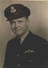
Photo of Bluey Truscott. Squadron Leader Keith William (Bluey) Truscott was regarded as one of Australia’s most well known WW2 fighter pilot aces. He was born on the 17/5/1916 and died over Exmouth, Western Australia on 28/3/1943 in an Aircraft accident whilst on duty. He initially trained under the Commonwealth Empire Training Scheme In Canada at the beginning of WW2, and later on was posted to Number 452 Squadron England where he flew Spitfires over Europe. He was awarded the distinguished Flying Cross in 1941 for his Air action and bravery. In 1942 he was further awarded the DFC Bar for further outstanding Air action and bravery. He returned to Australia and commanded number 76 Squadron who undertook duties in Papua New Guinea, specifically Milne Bay. When with 76 Squadron they largely flew Kittyhawks. There is a club named after SQN LDR Truscott, called the Truscott Club, at Airforce Base Darwin. There is also a decommissioned WW2 Airfield in the Kimberley’s called after him ( Truscott Air Base). Truscott has more recently been called Mungalu-Truscott Air Base as it is now owned by the traditional people of the Wunambal Gaambera. The Airfield is now used for commercial and private flying and is heritage listed under the National Trust of Australia (W.A.) due to its historical significance relating to WW2 and the remaining artefacts that are still in place presently. Bluey Truscott was also a well known Australian Rules Football player prior to WW2 having played for Melbourne. Photograph of Keith William (Bluey) Truscott in uniform.ww2, bluey truscott, flying cross -
 Melbourne Athenaeum Archives
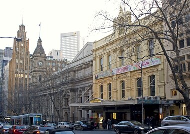
Video - ABC 7.30 Report: The Athenaeum 's 170th birthday, Australian Broadcasting Corporation, Melbourne, Athenaeum building celebrates 170 years, 11/11/2009
Transcript: Athenaeum building celebrates 170 years Australian Broadcasting Corporation Broadcast: 11/11/2009 Reporter: Lisa Whitehead Tomorrow marks the 170th birthday of one of the nation's historic cultural landmarks. Melbourne’s Athenaeum building has, in one form or other, provided education and entertainment for the Victorian colony as it became a city; and along the way, documented its growth. Transcript KERRY O’BRIEN, PRESENTER: Tomorrow marks the 170th birthday of one of the nation's historic cultural landmarks. Melbourne's Athenaeum building has, in one form or another, provided education and entertainment. For the Victorian colonies it became a city and along the way documented its growth. The building's original library and theatre still draw devotees and as Lisa Whitehead reports, a loyal band of volunteers. KEVIN QUIGLEY, ATHENAEUM PRESIDENT: There's nothing like us that has been here from day one, four years after the boat pushed ashore, here we are. It's a thread that runs through the life of Melbourne. LISA WHITEHEAD, REPORTER: In the heart of Melbourne's CBD, the Athenaeum is a celebrity in disguise, the oldest cultural icon in the city, but barely noticed. MARJORIE DALVEAN, VOLUNTEER HISTORIAN: People of Melbourne walk past this area and they have no idea what it is. RAY LAWLER, PLAYWRIGHT: It seemed to me to be a place that absolutely, or breathes Melbourne, I suppose, culture. LISA WHITEHEAD: Just four years after Melbourne was founded, the colony built a Mechanic's Institution, one of the first in the world, a place where the working class could meet and learn. KEVIN QUIGLEY: People think of it as Wild West sort of place where these hearty types drank and rushed about, but Melbourne was freely settled. It was a city of people who wanted to better themselves - entrepreneurs. And the Mechanic's Institution was that innovative idea that had grown up in Edinburgh and London about providing an opportunity for education for the working people. LISA WHITEHEAD: Mark Twain lectured there. Later, other buildings were added and a theatre to host classic plays. And it adopted its more bourgeois friendly title of the Athenaeum. Crucially from the start there was the library, the first to offer affordable lending to the working man. And it still attracts devotees. Former University lecturer Margaret Bowman, 89, comes in every Wednesday, along with her dog to join an enthusiastic band of volunteers sorting through the archives. MARGARET BOWMAN, FORMER UNIVERSITY LECTURER: Doing research is something that I find actually I enjoy more than anything. Every old lady needs to have a project and now I've got a project. MARJORIE DALVEAN: Margaret, Christine has just found out that Alfred Deakin was a member here from 1874 to 1877. This place is not flashy, we've never been flashy. But book lovers walk in here and they know this is the place for them. ARCHIVAL FOOTAGE: Old times and old names. The Athenaeum theatre in Melbourne for more than 40 years has been one of the city's best known cinemas. LISA WHITEHEAD: In the 20th century, the theatre surrendered to the new craze of talking pictures, and one particular fan was famous Australian playwright Ray Lawler. At 13, he dropped out of school to work in a Footscray factory and two years later his first trip to the glamorous Athenaeum cinema hinted at the education he was missing. RAY LAWLER: It just had a style about it which I responded to, I think. I was looking for something and this seemed to be part of it. Ray Lawler went on to write "Summer of the Seventeenth Doll" and found literary fame overseas. About a century after it had started as an educational place for the working man, Ray Lawler had, in effect, become an Athenaeum graduate. RAL LAWLER: If they had been looking for the sort of person that they were hoping to encourage along the way, I suppose I would have been somebody that might have fitted the mould, you know. LISA WHITEHEAD: In time, the cinema was returned to its theatrical roots. FRANK THRING, 1977: It has a great resemblance to the Theatre Royal in Hobart which Larry Olivier has called the best theatre he's ever worked in. And it's almost identical. It is the true Victorian playhouse. The horseshoe shaped thing: stalls, dress circle and gallery. And you're close to the audience and they're close to you. Marvellous feeling. LISA WHITEHEAD: Today, it's still a theatre. But time has brought compromises. The once vaunted art gallery has now covered its windows and become a comedy club and performance space. TV and suburban life have eaten away at the library membership. It offers an online service now, and a recent federal government grant will pay for the upkeep of its gracious interior, including the 1930s elevator Ray Lawler used to ride. For him, it's money well spent on history quietly made and discreetly observed. RAY LAWLER: It's the lack of awareness, I think, that people don't know what they've got here. They've really got the whole history of Melbourne almost. KEVIN QUIGLEY: It was a similar organisation in Sydney but we are the only one that's got a continual lineage on the same spot. We started here and we're still here and we'll be here for another 100 years. KERRY O'BRIEN: Lisa Whitehead on a great Melbourne landmark. © 2010 ABC | Privacy Policy Beginning as the Melbourne Mechanics' Institution in 1839, the Melbourne Athenaeum has a long history that reflects the cultural and social development of Melbourne. It continues to be managed as a not-for-profit organisation by a volunteer board, with a subscription library (maintained since 1839) and a leased theatre.Video broadcast ABC 7:30 Report for 11/11/2009. "Tomorrow marks the 170th birthday of one of the nation's historic cultural landmarks. Melbourne’s Athenaeum building has, in one form or other, provided education and entertainment for the Victorian colony as it became a city; and along the way, documented its growth."athenaeum, australian broadcasting corporation, kerry o’brien, kevin quigley, lisa whitehead, marjorie dalvean, ray lawler, margaret bowman, frank thring. -
 Box Hill Historical Society
Book, Endacott, Sydney J, Australian Aboriginal Words and place names and their meanings, 1985
... a great many Australian aboriginal place-names and their meanings ...A compilation of Australian Aboriginal Words and places names and their meanings. The book contains about 3000 words and meanings of various things and matters, including a great many Australian aboriginal place-names and their meanings. The book also contains three photographs of aborigines.64 pages non-fictionA compilation of Australian Aboriginal Words and places names and their meanings. The book contains about 3000 words and meanings of various things and matters, including a great many Australian aboriginal place-names and their meanings. The book also contains three photographs of aborigines.australian aboriginal language, language -
 Nillumbik Shire Council
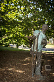
Public Art: Marcus SKIPPER (b.1950 Melb, Aus), Marcus Skipper, Alan Marshall (Location: Grounds of Eltham Library, Panther Place, Eltham), 1995
Alan Marshall was an author of more than fifteen books, and lived much of his life in Eltham. He became a central figure in the area's arts community of writers, artists, sculptors, film makers, actors and musicians. He is shown stroking a book to his heart, perched on a crutch, which references his disability (contracted polio when he was young), and his status as one of Australia's most successful and loved authors. His most famous book, 'I Can Jump Puddles' is based on his life story and the obstacles he faced as a child in trying to overcome his disability. Marcus Skipper submitted the idea for the work to the first 'Art in Public Places' Awards in 1990. The selectors at the time recommended that the work would be more suitably placed near the Eltham Library. It was commissioned and installed for the new Eltham Library, which was designed by Greg Burgess in 1994. It was partially funded by the then Shire of Eltham's Art Development Fund (Eltham Arts Council) and the rest donated by the artist Marcus Skipper. This work has significance for its reference to two well known names associated with Eltham and its history. The sculpture is a realistic statue of the famous Australian author Alan Marshall who wrote "I Can Jump Puddles". He lived and worked in the Shire. The artist Marcus Skipper represents a highly recognised family of artists associated with Monsalvat. The sculpture 'Alan marshall' has been classified as of regional significance by the National Trust of Australia. A realistic depiction (almost life size) of Alan Marshall cast in bronze with green patination. Dressed in a jumper and slacks, Marshall is shown perched on a crutch, holding a book to his heart, gesturing to his audience to come and listen to his words. alan marshall, bronze, skipper, i can jump puddles, eltham library, novalist, ekphrasis2017, figure, public art -
 Peterborough History Group
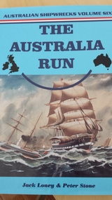
Book, The Australia Run, Published 2000
Detailed description of immigrant shipping route to Australia, including references to local shipwrecks317 page book with bibliography, general index, index of place names, index of surnames, index of ships. Volume 6 of Australian Shipwrecks series.peterborough 3270, great ocean road, schomberg-shipwreck, newfield-shipwreck, young australia-shipwreck, curdies inlet, the australia run shipping route, shipwreck coast -
Koorie Heritage Trust
Book, Briggs, Carolyn, The journey cycles of the Boonwurrung : stories with Boonwurrung language, 2008
The stories constitute maintaining and reclaiming heritage and carries forward the language and knowledge to the guests in Boonwurrung country. The significance of these stories is that they constitute maintaining and reclaiming heritage. They were given to the author over many years. They are a legacy of her people, and it is her responsibility to pass them on. "This stories edition is adapted from text edition by John O'meara courtesy Bayside City Council."v-xi; 51 P.; ill.; lists.The stories constitute maintaining and reclaiming heritage and carries forward the language and knowledge to the guests in Boonwurrung country. The significance of these stories is that they constitute maintaining and reclaiming heritage. They were given to the author over many years. They are a legacy of her people, and it is her responsibility to pass them on. "This stories edition is adapted from text edition by John O'meara courtesy Bayside City Council."derrimut, -1864. | benbow, -1852. | briggs, louisa, 1836-1925. | language - vocabulary - word lists. | sites - quarries - ochre and pigment. | material culture. | environment - climate and weather - seasons. | literature and stories. | language - vocabulary - place names. | boonwurrung / boonerwrung / bunurong language (s35) (vic sj55-09) | boonwurrung / boonerwrung / bunurong people (s35) (vic sj55-09) | aboriginal australians -- folklore. | australian languages -- victoria. | language revival -- victoria. | dreamtime (aboriginal australian mythology) -- victoria. | material culture -- victoria. | ocher -- victoria. | seasons -- victoria. | bayside (vic sj55-05) | australian. -
Dandenong/Cranbourne RSL Sub Branch
Frame of "The Storey Begins", The Australian New Zealand Army Corps .....Lest We Forget
Gold painted wooden framed photograph of 'The Legend of Anzac" with 15 stories are displayed on a cut out on red background. -The Legend Begins -The Land and the Landing -The Chance of a Lifetime-Every Man A Volunteer -The Dardanelles -The Enemy Face- Johnny Turk -Making Do - Home Was Never Like This -An Informal Armistice -A new Landing - The Breakout -Dardanelles Committee -The Home Front -The New Enemy - Winter -Evacuation - The Great Deception -A.N.Z.A.C. Names and Places -Battle Honours, Flags, Drums and Medals -A.N.Z.A,C. … Lest WE Forget. Stating on the top left 2 Australian Medals Gallipoli Star Medal - Victory Medal (next) Rising Sun Badge NZ Expeditionary badge Victory Medal NZ Star Medal Australian Gallipoli Star Medal - The four medal star is bright bronze ensigned with a crown the obverse has cross gladius overlaid with oak wreath that is ensigned with the cypher of Ki ng George V. A scroll bearing the legend 1914-15 is centrally placed across the blades was authorised in 1918 and awarded for service in specified theatres of war between 5th Aug 1914 & 31st Dec 1915. Australian and New Zealand Victory medal is a United Kingdom and British First World War Campaign Medal. The award of a common allied campaign recommended in March 1919. The New Zealand Star Medal, designed R.K. Peacock, eight pointed star (representing NZ and the seven Territories of Australia) surrounding a silver disc with the words " Gallipoli 1914-15. -
Unions Ballarat
Massacre at Eureka : the untold story, O'Brien, Bob, 1992
Untold story of the Eureka Stockade (3 December 1854). The rebellion at Eureka arose as a protest against compulsory mining licences for gold miners and led to the siege at the Stockade by colonial forces.Local significance. Relevant to the history of the Eureka Stockade that took place in Ballarat in 1854.Paper; book. Front cover: Red, blue and black background with an artistic rendition of the battle of Eureka. Yellow and white text. Front cover: author name and title.btlc, ballarat trades hall, ballarat trades and labour council, eureka stockade, eureka lead, gold mining - ballarat, mining licences - ballarat, civil disobedience, lalor, peter, scobie, james, ballarat reform league, bentley, james, humffray, john, southern cross, australian history -
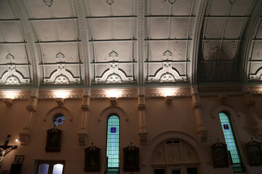
 Ballarat Heritage Services
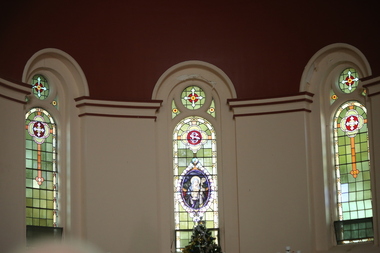
Photograph - Digital photographs, L.J. Gervasoni, St Brigid's Crossley - stained glass window, 2016
"LARGE GATHERINGNG AT - CROSSLEY DEDICATION AND OPENING SERVICES. SERMON BY DR. MANNIX. Yesterday was an important and historic day for the Roman Catholic community of Crossley and Koroit, in as much as it will be always associated in the memories of all con cerned with the opening of the new St. Brigid's Church, Crossley. This building is far above the average standard of sacred edifices in country towns, and is certainly superior to any ercted in this district outside the churches in the two larger centres - Warrnambool and Koroit. The style of architecture chosen is a free treatment of the Romanesque, which is something quite original in the Western District. This noble style, from which, with its near re lative the Byzantine, spring the great Gothic school of architecture, is characterised by a special charm of its own, one of its chief features being graceful and sweeping circular curves in roof, window heads and in the ar rangenent of the ground plan. The building is of brick finished off with true Romanesqiue pillared pinnacles in concrete and plaster, the brick and concrete producing a pleasing contrast. The main characteristic of the front is a large rose window filled with Romlanesque circular tracery, and below a bold porch and entrance. The two sides are pierced with long circular-headed windows between graceful buttresses and the wall line is pleasingly broken by the projecting bays of the confessionals and also by the vestries. The main building is 80 feet by 30 feet' and the Sanctuary is spacious and semi-circular in shape, and lighted by three windows. The interior of the church is most artistic. The ceiling is semi-circular and of fibrous plaster in ornate designs. All the windows are lead lighted, throwing a rich and mellow harmony of' color throughout the interior and the white wails, mouldings, architraves and other fibrous plaster decorations: are further relieved by the rich coloring: in the stations of.the Cross arrranged around the nave. The central window of the Sanctuary contains a splendidly executed stained glass representation of St. Brigid. At.the western end is a room gallery. The altar is a choice piece of Gothic woodwork, in light, soft coloring, and there are two altars on either side of the Sanctuary in oak, and above whlch are very fine colored figures of Christ; and the Madonna. On either side of the altar are life-size figures of angels holding high brass candalabra. The whole of the furnishings of the church are on a sumptuous scale, and the edifice reflects credit on all concerned. The church can seat nearly 500 people. The architect was Mr. A. A. Fritsch. of Melbourne, and the contractors Messrs F. and E. Deagne, of North Fitzroy. The contract price for the building was £5,500. THE OPENING SERVICE. After the cereimony of solemnly blesssing the church was performed by His Lordship the Bishop of the Diocese, Dr. Higgins, assisted by His Grace the Coadjutor Archbishop of Melbourne. Dr. Mannix, the great gatheiring from all parts of the district entered the church, which was soon completely filled. The members of the H.A.C.B.S. attended wearing their green and gold regalia, and acted as a 'guard of honor' to the Co-adjlutor Arclhbishop and Bishop. Mass was celebrated by the Rev. Father Phelan, of Koroit, and a feature of the solemn service was the singing of a choir which consisted of picked voices from St. Carthage's choir, with friends from Warrnam bool and assisted by some of the mem bers of the Koroit choir, with Miss Logan as organist and Mr. Arthur H. Renwick as conductor. They rendered the music in splendid style throghonut. The "Kyrie," "Gloria." "Agnus Dei' and Dona Nobis" were from Farmer's Mass in B flat, and the "Credo" and "Sanctus" from Webbe's Mass in G. The soloists in the Mass were Mrs. Ryan, the Misses McEntee. Miss Katie O'Brien. and Messrs. J. M. Crowley, W. J. Callaghan; B. McEntee and W. Mahony. The chorus sang with great precision, special attention being paid to at tack. At the offertory Mrs. Dan Ryan gave a beautiful rendering of Gounod's "Ava Maria." After the Elevation that fine duet "Tantum Ergo." by Rossi, was sung by Messrs. Crowley and Renwick in an artistic manner, their fine voices blending splendidly. During the collection, Mr. Renwick sang with much feeling that devotional solo, "Lead Thou Me On,", after which Mr Crowley gave .an ex cellent rendering of Weissi's "0 Salu taris Hostia;" and the choir sang several hymns." It might here be mentioned that at the request of Fa ther Kerin, the same choir will repeat the music.at the Koroit Church on Sunday next, on the occasion of the ceremnly of laying the foundation stone of the cormpletion of the church. Dr. Mannix preachled the sermon for the occasion, taking his text from St. Luke first 11 verses. He re viewed the Gospel story of Christ preaching to the multitude from a boat on Lake Gennesaret and the miraculous draught of fish. The obedi ence of the poor fishermen in casting their nets at Christ's bidding was richly rewarded, and the miraculous occurrence was a striking example of what was to happen when Christ established His Church and built it up on those twelve apostles. When they came to think of it, nothing so re markable and marvellous had happened before or since in the history of mankind. The world at that time was for the most part a Pagan world steeped in iniquity and sin. The chosen people of God had God's re velation, but they worshipped with their lips and not with their hearts. When Christ was to establish His Church upon earth and leave an or gantisation that would continue His work, did He select learned men, powerful men, rich men, or a time that would seem propituous? No. He selected twelve poor, igorant simple fishermen, without money, power, learning or anything calculated to enable them to do anything striking in the world's history. The success of the first morning after pentecost was not confined to those first days when the plentitude of the Holy Ghost sat upon the .Apostles, but it continued age after age until the whole world was brought within the sphere of ac tion of the Church. Greece, Rome Europe Asia and America, and now Australia had been brought into the net. This must be a consolation to them all as well as it was to him (the preacher), when they remembered that they came from a land which of all others had been faithful to the Gospel of Jesus Christ. It was a consolation to them that in that great work that had been accomplished in bringing men into the meshes of the Church, and bringing them to God the nation to which they belontged had taken so great a part. Their religion flourished in England, Scotland, America and Australia. Surely it was due to the sons of St. Patrick, the sons and daughters of Ireland to find consolation in these great facts might It might seem hard that so many had to leave their native-land for England, Scotland, America and Australia. But if hard it was the means of keeping the Catholic faith living in England and Scotland. If to-day the Irish Catholics and Catholics of Irish de scent were taken out of the English and Scotch population there would be little left of the true Church of God. It seemed hard to emigrate to distant lands, but the result had been the new magnificent church in the United States, the flourishing churches in Canada and South Africa. Those Irish emigrants were a cornparatively small band. Perhaps they had not the learning of other nations. Certainly they had not the wealth and it did not fall to their lot to have the power of the sword, but God was with them, and the faith they took from Ireland flourished in those distant lands. In this fair land of Australia they had a glorious herit age handed down from the pioneer Irish Catholics, who came to this fair Austral land. There was a time when those who were opposed to God and God's Church,thought that Australia should be a wholly Protestant land. They had lived to see whether God or His enemies were the stronger. They had lived to see that those who in distant days would have stamped out the Catholic religion in Australia, had not prevailed. Their names had been forgotten because of their persecution of the Catholic Church, and they had lived - to see the glorious success that now, in every part of the Common wealth, rested upon the Catholic Church in Australia. Might God bless that Church and those Irish people, and the people of Irish descent, who had built it up. In that locality, and there was no place in.the Common wealth where the Catholic Church was held in higher esteem, the people would always be faithful to God and His Church. That beautiful building, and all it signified in loyalty and faithfulness, was a credit and a consolation to the Bishop and people of the diocese, to the architect who had done his work so artistically and skil fully. to the priests and the zealous administration of the parish. There was surely hope and inspiration in that day's celebration, that as time went on the Catholic faith would sink deeper and deeper into ther coming generation, and that the Catholic progress of the past 50 years would be small in comparison to the great progress of the future. He congratulated the Bishop priests and people who had raised that temple. He congratulated the people of Crossley; upon their generosity and self-sacrifice, and he prayed that God's blessing and the blessing of St. Brigid would rest upon them; their children and children's children. And when those who had received the sacraments and had been instructed in that Church were called before the Judgment Seat he pray ed that not one would be missing, and St. Peter aind St. Brigid would be able to count them all into the en joyment .of Eternal bliss. THE CELEBRATION The Rev. Father Kerin, Adninistra tor of the Parish, after the collection, read a lengthy list of the principal donations, headed by the Bishop, Dr. Higgins, with £250. All the furnish ings of the Church were also donations, and the Coadjutor-Archbishop added £5 to the list. The Rev. Father Kerin stated that the total to hand was £1245/10/7, which was an other proof of the generosity of the Crossley and district people. The amount previously received in donations was £1077/3. They started buildiing with a credit balance of £262 10/5 and ther now had a debit balance of £2,728/18/5. The total cost of the Church was £6,250, so that they would see the greater part of the indebtedness had already been wiped out. The Bishop (Dr. Higgins) delivered a brief address, in the course of which he congratulated the priests and people upon the completion of their magnificent Church. He congratulated the people on their magnificent generosity. He expressed his of deep indebtedness to the Coadjutor Archbishop of Melbourne for the services he had rendered to them. He had attended at considerable sacrifice to himself, and they were extremely grateful for the presence of so distinguished a champion who had shown such zeal and interest in their Church in this new land. He (the Bishop) trusted that his splendid talents would long be devoted to the defence of the Church." (Warrnambul Standard, 02 July 1914)Digital images of the stained glass windows at St Brigid's, Crossley.victoria, crossley, st brigid's crossley, st brigid's, catholic church, catholic, church, religion, stained glass, window -
 Ballarat Heritage Services
Digital photographs, St Brigid's Crossley - Christmas Carols, 2016, Christmas 2016
"LARGE GATHERINGNG AT - CROSSLEY DEDICATION AND OPENING SERVICES. SERMON BY DR. MANNIX. Yesterday was an important and historic day for the Roman Catholic community of Crossley and Koroit, in as much as it will be always associated in the memories of all con cerned with the opening of the new St. Brigid's Church, Crossley. This building is far above the average standard of sacred edifices in country towns, and is certainly superior to any ercted in this district outside the churches in the two larger centres - Warrnambool and Koroit. The style of architecture chosen is a free treatment of the Romanesque, which is something quite original in the Western District. This noble style, from which, with its near re lative the Byzantine, spring the great Gothic school of architecture, is characterised by a special charm of its own, one of its chief features being graceful and sweeping circular curves in roof, window heads and in the ar rangenent of the ground plan. The building is of brick finished off with true Romanesqiue pillared pinnacles in concrete and plaster, the brick and concrete producing a pleasing contrast. The main characteristic of the front is a large rose window filled with Romlanesque circular tracery, and below a bold porch and entrance. The two sides are pierced with long circular-headed windows between graceful buttresses and the wall line is pleasingly broken by the projecting bays of the confessionals and also by the vestries. The main building is 80 feet by 30 feet' and the Sanctuary is spacious and semi-circular in shape, and lighted by three windows. The interior of the church is most artistic. The ceiling is semi-circular and of fibrous plaster in ornate designs. All the windows are lead lighted, throwing a rich and mellow harmony of' color throughout the interior and the white wails, mouldings, architraves and other fibrous plaster decorations: are further relieved by the rich coloring: in the stations of.the Cross arrranged around the nave. The central window of the Sanctuary contains a splendidly executed stained glass representation of St. Brigid. At.the western end is a room gallery. The altar is a choice piece of Gothic woodwork, in light, soft coloring, and there are two altars on either side of the Sanctuary in oak, and above whlch are very fine colored figures of Christ; and the Madonna. On either side of the altar are life-size figures of angels holding high brass candalabra. The whole of the furnishings of the church are on a sumptuous scale, and the edifice reflects credit on all concerned. The church can seat nearly 500 people. The architect was Mr. A. A. Fritsch. of Melbourne, and the contractors Messrs F. and E. Deagne, of North Fitzroy. The contract price for the building was £5,500. THE OPENING SERVICE. After the cereimony of solemnly blesssing the church was performed by His Lordship the Bishop of the Diocese, Dr. Higgins, assisted by His Grace the Coadjutor Archbishop of Melbourne. Dr. Mannix, the great gatheiring from all parts of the district entered the church, which was soon completely filled. The members of the H.A.C.B.S. attended wearing their green and gold regalia, and acted as a 'guard of honor' to the Co-adjlutor Arclhbishop and Bishop. Mass was celebrated by the Rev. Father Phelan, of Koroit, and a feature of the solemn service was the singing of a choir which consisted of picked voices from St. Carthage's choir, with friends from Warrnam bool and assisted by some of the mem bers of the Koroit choir, with Miss Logan as organist and Mr. Arthur H. Renwick as conductor. They rendered the music in splendid style throghonut. The "Kyrie," "Gloria." "Agnus Dei' and Dona Nobis" were from Farmer's Mass in B flat, and the "Credo" and "Sanctus" from Webbe's Mass in G. The soloists in the Mass were Mrs. Ryan, the Misses McEntee. Miss Katie O'Brien. and Messrs. J. M. Crowley, W. J. Callaghan; B. McEntee and W. Mahony. The chorus sang with great precision, special attention being paid to at tack. At the offertory Mrs. Dan Ryan gave a beautiful rendering of Gounod's "Ava Maria." After the Elevation that fine duet "Tantum Ergo." by Rossi, was sung by Messrs. Crowley and Renwick in an artistic manner, their fine voices blending splendidly. During the collection, Mr. Renwick sang with much feeling that devotional solo, "Lead Thou Me On,", after which Mr Crowley gave .an ex cellent rendering of Weissi's "0 Salu taris Hostia;" and the choir sang several hymns." It might here be mentioned that at the request of Fa ther Kerin, the same choir will repeat the music.at the Koroit Church on Sunday next, on the occasion of the ceremnly of laying the foundation stone of the cormpletion of the church. Dr. Mannix preachled the sermon for the occasion, taking his text from St. Luke first 11 verses. He re viewed the Gospel story of Christ preaching to the multitude from a boat on Lake Gennesaret and the miraculous draught of fish. The obedi ence of the poor fishermen in casting their nets at Christ's bidding was richly rewarded, and the miraculous occurrence was a striking example of what was to happen when Christ established His Church and built it up on those twelve apostles. When they came to think of it, nothing so re markable and marvellous had happened before or since in the history of mankind. The world at that time was for the most part a Pagan world steeped in iniquity and sin. The chosen people of God had God's re velation, but they worshipped with their lips and not with their hearts. When Christ was to establish His Church upon earth and leave an or gantisation that would continue His work, did He select learned men, powerful men, rich men, or a time that would seem propituous? No. He selected twelve poor, igorant simple fishermen, without money, power, learning or anything calculated to enable them to do anything striking in the world's history. The success of the first morning after pentecost was not confined to those first days when the plentitude of the Holy Ghost sat upon the .Apostles, but it continued age after age until the whole world was brought within the sphere of ac tion of the Church. Greece, Rome Europe Asia and America, and now Australia had been brought into the net. This must be a consolation to them all as well as it was to him (the preacher), when they remembered that they came from a land which of all others had been faithful to the Gospel of Jesus Christ. It was a consolation to them that in that great work that had been accomplished in bringing men into the meshes of the Church, and bringing them to God the nation to which they belontged had taken so great a part. Their religion flourished in England, Scotland, America and Australia. Surely it was due to the sons of St. Patrick, the sons and daughters of Ireland to find consolation in these great facts might It might seem hard that so many had to leave their native-land for England, Scotland, America and Australia. But if hard it was the means of keeping the Catholic faith living in England and Scotland. If to-day the Irish Catholics and Catholics of Irish de scent were taken out of the English and Scotch population there would be little left of the true Church of God. It seemed hard to emigrate to distant lands, but the result had been the new magnificent church in the United States, the flourishing churches in Canada and South Africa. Those Irish emigrants were a cornparatively small band. Perhaps they had not the learning of other nations. Certainly they had not the wealth and it did not fall to their lot to have the power of the sword, but God was with them, and the faith they took from Ireland flourished in those distant lands. In this fair land of Australia they had a glorious herit age handed down from the pioneer Irish Catholics, who came to this fair Austral land. There was a time when those who were opposed to God and God's Church,thought that Australia should be a wholly Protestant land. They had lived to see whether God or His enemies were the stronger. They had lived to see that those who in distant days would have stamped out the Catholic religion in Australia, had not prevailed. Their names had been forgotten because of their persecution of the Catholic Church, and they had lived - to see the glorious success that now, in every part of the Common wealth, rested upon the Catholic Church in Australia. Might God bless that Church and those Irish people, and the people of Irish descent, who had built it up. In that locality, and there was no place in.the Common wealth where the Catholic Church was held in higher esteem, the people would always be faithful to God and His Church. That beautiful building, and all it signified in loyalty and faithfulness, was a credit and a consolation to the Bishop and people of the diocese, to the architect who had done his work so artistically and skil fully. to the priests and the zealous administration of the parish. There was surely hope and inspiration in that day's celebration, that as time went on the Catholic faith would sink deeper and deeper into ther coming generation, and that the Catholic progress of the past 50 years would be small in comparison to the great progress of the future. He congratulated the Bishop priests and people who had raised that temple. He congratulated the people of Crossley; upon their generosity and self-sacrifice, and he prayed that God's blessing and the blessing of St. Brigid would rest upon them; their children and children's children. And when those who had received the sacraments and had been instructed in that Church were called before the Judgment Seat he pray ed that not one would be missing, and St. Peter aind St. Brigid would be able to count them all into the en joyment .of Eternal bliss. THE CELEBRATION The Rev. Father Kerin, Adninistra tor of the Parish, after the collection, read a lengthy list of the principal donations, headed by the Bishop, Dr. Higgins, with £250. All the furnish ings of the Church were also donations, and the Coadjutor-Archbishop added £5 to the list. The Rev. Father Kerin stated that the total to hand was £1245/10/7, which was an other proof of the generosity of the Crossley and district people. The amount previously received in donations was £1077/3. They started buildiing with a credit balance of £262 10/5 and ther now had a debit balance of £2,728/18/5. The total cost of the Church was £6,250, so that they would see the greater part of the indebtedness had already been wiped out. The Bishop (Dr. Higgins) delivered a brief address, in the course of which he congratulated the priests and people upon the completion of their magnificent Church. He congratulated the people on their magnificent generosity. He expressed his of deep indebtedness to the Coadjutor Archbishop of Melbourne for the services he had rendered to them. He had attended at considerable sacrifice to himself, and they were extremely grateful for the presence of so distinguished a champion who had shown such zeal and interest in their Church in this new land. He (the Bishop) trusted that his splendid talents would long be devoted to the defence of the Church." (Warrnambul Standard, 02 July 1914)Digital images of the interior of St Brigid's, Crossley.st brigid's crossley, st brigid's, catholic church, catholic, church, religion, celebrations, christmas, christmas carols, carols, stained glass, window -
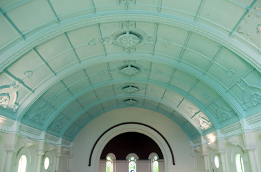 Ballarat Heritage Services
Photograph - Digital photographs, L.J. Gervasoni, Interior of St Brigid's Crossley, C2016
"LARGE GATHERINGNG AT - CROSSLEY DEDICATION AND OPENING SERVICES. SERMON BY DR. MANNIX. Yesterday was an important and historic day for the Roman Catholic community of Crossley and Koroit, in as much as it will be always associated in the memories of all con cerned with the opening of the new St. Brigid's Church, Crossley. This building is far above the average standard of sacred edifices in country towns, and is certainly superior to any ercted in this district outside the churches in the two larger centres - Warrnambool and Koroit. The style of architecture chosen is a free treatment of the Romanesque, which is something quite original in the Western District. This noble style, from which, with its near re lative the Byzantine, spring the great Gothic school of architecture, is characterised by a special charm of its own, one of its chief features being graceful and sweeping circular curves in roof, window heads and in the ar rangenent of the ground plan. The building is of brick finished off with true Romanesqiue pillared pinnacles in concrete and plaster, the brick and concrete producing a pleasing contrast. The main characteristic of the front is a large rose window filled with Romlanesque circular tracery, and below a bold porch and entrance. The two sides are pierced with long circular-headed windows between graceful buttresses and the wall line is pleasingly broken by the projecting bays of the confessionals and also by the vestries. The main building is 80 feet by 30 feet' and the Sanctuary is spacious and semi-circular in shape, and lighted by three windows. The interior of the church is most artistic. The ceiling is semi-circular and of fibrous plaster in ornate designs. All the windows are lead lighted, throwing a rich and mellow harmony of' color throughout the interior and the white wails, mouldings, architraves and other fibrous plaster decorations: are further relieved by the rich coloring: in the stations of.the Cross arrranged around the nave. The central window of the Sanctuary contains a splendidly executed stained glass representation of St. Brigid. At.the western end is a room gallery. The altar is a choice piece of Gothic woodwork, in light, soft coloring, and there are two altars on either side of the Sanctuary in oak, and above whlch are very fine colored figures of Christ; and the Madonna. On either side of the altar are life-size figures of angels holding high brass candalabra. The whole of the furnishings of the church are on a sumptuous scale, and the edifice reflects credit on all concerned. The church can seat nearly 500 people. The architect was Mr. A. A. Fritsch. of Melbourne, and the contractors Messrs F. and E. Deagne, of North Fitzroy. The contract price for the building was £5,500. THE OPENING SERVICE. After the cereimony of solemnly blesssing the church was performed by His Lordship the Bishop of the Diocese, Dr. Higgins, assisted by His Grace the Coadjutor Archbishop of Melbourne. Dr. Mannix, the great gatheiring from all parts of the district entered the church, which was soon completely filled. The members of the H.A.C.B.S. attended wearing their green and gold regalia, and acted as a 'guard of honor' to the Co-adjlutor Arclhbishop and Bishop. Mass was celebrated by the Rev. Father Phelan, of Koroit, and a feature of the solemn service was the singing of a choir which consisted of picked voices from St. Carthage's choir, with friends from Warrnam bool and assisted by some of the mem bers of the Koroit choir, with Miss Logan as organist and Mr. Arthur H. Renwick as conductor. They rendered the music in splendid style throghonut. The "Kyrie," "Gloria." "Agnus Dei' and Dona Nobis" were from Farmer's Mass in B flat, and the "Credo" and "Sanctus" from Webbe's Mass in G. The soloists in the Mass were Mrs. Ryan, the Misses McEntee. Miss Katie O'Brien. and Messrs. J. M. Crowley, W. J. Callaghan; B. McEntee and W. Mahony. The chorus sang with great precision, special attention being paid to at tack. At the offertory Mrs. Dan Ryan gave a beautiful rendering of Gounod's "Ava Maria." After the Elevation that fine duet "Tantum Ergo." by Rossi, was sung by Messrs. Crowley and Renwick in an artistic manner, their fine voices blending splendidly. During the collection, Mr. Renwick sang with much feeling that devotional solo, "Lead Thou Me On,", after which Mr Crowley gave .an ex cellent rendering of Weissi's "0 Salu taris Hostia;" and the choir sang several hymns." It might here be mentioned that at the request of Fa ther Kerin, the same choir will repeat the music.at the Koroit Church on Sunday next, on the occasion of the ceremnly of laying the foundation stone of the cormpletion of the church. Dr. Mannix preachled the sermon for the occasion, taking his text from St. Luke first 11 verses. He re viewed the Gospel story of Christ preaching to the multitude from a boat on Lake Gennesaret and the miraculous draught of fish. The obedi ence of the poor fishermen in casting their nets at Christ's bidding was richly rewarded, and the miraculous occurrence was a striking example of what was to happen when Christ established His Church and built it up on those twelve apostles. When they came to think of it, nothing so re markable and marvellous had happened before or since in the history of mankind. The world at that time was for the most part a Pagan world steeped in iniquity and sin. The chosen people of God had God's re velation, but they worshipped with their lips and not with their hearts. When Christ was to establish His Church upon earth and leave an or gantisation that would continue His work, did He select learned men, powerful men, rich men, or a time that would seem propituous? No. He selected twelve poor, igorant simple fishermen, without money, power, learning or anything calculated to enable them to do anything striking in the world's history. The success of the first morning after pentecost was not confined to those first days when the plentitude of the Holy Ghost sat upon the .Apostles, but it continued age after age until the whole world was brought within the sphere of ac tion of the Church. Greece, Rome Europe Asia and America, and now Australia had been brought into the net. This must be a consolation to them all as well as it was to him (the preacher), when they remembered that they came from a land which of all others had been faithful to the Gospel of Jesus Christ. It was a consolation to them that in that great work that had been accomplished in bringing men into the meshes of the Church, and bringing them to God the nation to which they belontged had taken so great a part. Their religion flourished in England, Scotland, America and Australia. Surely it was due to the sons of St. Patrick, the sons and daughters of Ireland to find consolation in these great facts might It might seem hard that so many had to leave their native-land for England, Scotland, America and Australia. But if hard it was the means of keeping the Catholic faith living in England and Scotland. If to-day the Irish Catholics and Catholics of Irish de scent were taken out of the English and Scotch population there would be little left of the true Church of God. It seemed hard to emigrate to distant lands, but the result had been the new magnificent church in the United States, the flourishing churches in Canada and South Africa. Those Irish emigrants were a cornparatively small band. Perhaps they had not the learning of other nations. Certainly they had not the wealth and it did not fall to their lot to have the power of the sword, but God was with them, and the faith they took from Ireland flourished in those distant lands. In this fair land of Australia they had a glorious herit age handed down from the pioneer Irish Catholics, who came to this fair Austral land. There was a time when those who were opposed to God and God's Church,thought that Australia should be a wholly Protestant land. They had lived to see whether God or His enemies were the stronger. They had lived to see that those who in distant days would have stamped out the Catholic religion in Australia, had not prevailed. Their names had been forgotten because of their persecution of the Catholic Church, and they had lived - to see the glorious success that now, in every part of the Common wealth, rested upon the Catholic Church in Australia. Might God bless that Church and those Irish people, and the people of Irish descent, who had built it up. In that locality, and there was no place in.the Common wealth where the Catholic Church was held in higher esteem, the people would always be faithful to God and His Church. That beautiful building, and all it signified in loyalty and faithfulness, was a credit and a consolation to the Bishop and people of the diocese, to the architect who had done his work so artistically and skil fully. to the priests and the zealous administration of the parish. There was surely hope and inspiration in that day's celebration, that as time went on the Catholic faith would sink deeper and deeper into ther coming generation, and that the Catholic progress of the past 50 years would be small in comparison to the great progress of the future. He congratulated the Bishop priests and people who had raised that temple. He congratulated the people of Crossley; upon their generosity and self-sacrifice, and he prayed that God's blessing and the blessing of St. Brigid would rest upon them; their children and children's children. And when those who had received the sacraments and had been instructed in that Church were called before the Judgment Seat he pray ed that not one would be missing, and St. Peter aind St. Brigid would be able to count them all into the en joyment .of Eternal bliss. THE CELEBRATION The Rev. Father Kerin, Adninistra tor of the Parish, after the collection, read a lengthy list of the principal donations, headed by the Bishop, Dr. Higgins, with £250. All the furnish ings of the Church were also donations, and the Coadjutor-Archbishop added £5 to the list. The Rev. Father Kerin stated that the total to hand was £1245/10/7, which was an other proof of the generosity of the Crossley and district people. The amount previously received in donations was £1077/3. They started buildiing with a credit balance of £262 10/5 and ther now had a debit balance of £2,728/18/5. The total cost of the Church was £6,250, so that they would see the greater part of the indebtedness had already been wiped out. The Bishop (Dr. Higgins) delivered a brief address, in the course of which he congratulated the priests and people upon the completion of their magnificent Church. He congratulated the people on their magnificent generosity. He expressed his of deep indebtedness to the Coadjutor Archbishop of Melbourne for the services he had rendered to them. He had attended at considerable sacrifice to himself, and they were extremely grateful for the presence of so distinguished a champion who had shown such zeal and interest in their Church in this new land. He (the Bishop) trusted that his splendid talents would long be devoted to the defence of the Church." (Warrnambul Standard, 02 July 1914)Digital images of the in..terior of St Brigid's Crossleyst brigid's crossley, st brigid's, catholic church, catholic, church, community, ceiling, stations of the cross, confessional, statues, windows -
Unions Ballarat
MUNGO : The Man Who Laughs, MacCallum, Mungo, 2001
A memoir and personal observations about political life particularly around the time of the Whitlam government (1972-1975). In the foreword, the author describes the book as not a serious piece of research, although names, dates and places have been checked.The book is significant to Australian federal politics, particularly during the Whitlam/ALP government.Paperback book. Front cover: red and background; black and white lettering; two tone portraits of Gough Whitlam (blue and black), William McMahon (purple and black) and John Gorton (green and black). Front cover: author's name and title. Back cover: excerpts from the book. Title page: the name Ray O'Leary and date 2/2012 is inscribed in blue biro.btlc, ballarat trades and labour council, ballarat trades hall, politics, whitlam, gough, mcmahan, william, gorton, john, australian labor party, liberal party australia, politicians, prime minister -
Unions Ballarat
Australian roundup 1790-1950, Broderick, Colin, 1953
A series of Australian short stories dating from 1790-1950.The editor, Colin Broderick, was known for promoting Australian literature. Fiction - of national interest. Hardcover, blue cloth paper amalgam; gold lettering on spine; 374 pages.Spine: title and author's name. Ararat Municipal Library stamp appears in several places on the inside of the book. Library loan slip and original card (2423) are located at the back. Last stamped on 20 Nov 1970.btlc, ballarat trades hall, ballarat trades and labour council, fiction - short stories, fiction - australian -
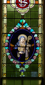 Ballarat Heritage Services
Photograph, Lisa Gervasoni, St Brigid Stained Glass Window, Crossley, 18/08/2013
"LARGE GATHERINGNG AT - CROSSLEY DEDICATION AND OPENING SERVICES. SERMON BY DR. MANNIX. Yesterday was an important and historic day for the Roman Catholic community of Crossley and Koroit, in as much as it will be always associated in the memories of all con cerned with the opening of the new St. Brigid's Church, Crossley. This building is far above the average standard of sacred edifices in country towns, and is certainly superior to any ercted in this district outside the churches in the two larger centres - Warrnambool and Koroit. The style of architecture chosen is a free treatment of the Romanesque, which is something quite original in the Western District. This noble style, from which, with its near re lative the Byzantine, spring the great Gothic school of architecture, is characterised by a special charm of its own, one of its chief features being graceful and sweeping circular curves in roof, window heads and in the ar rangenent of the ground plan. The building is of brick finished off with true Romanesqiue pillared pinnacles in concrete and plaster, the brick and concrete producing a pleasing contrast. The main characteristic of the front is a large rose window filled with Romlanesque circular tracery, and below a bold porch and entrance. The two sides are pierced with long circular-headed windows between graceful buttresses and the wall line is pleasingly broken by the projecting bays of the confessionals and also by the vestries. The main building is 80 feet by 30 feet' and the Sanctuary is spacious and semi-circular in shape, and lighted by three windows. The interior of the church is most artistic. The ceiling is semi-circular and of fibrous plaster in ornate designs. All the windows are lead lighted, throwing a rich and mellow harmony of' color throughout the interior and the white wails, mouldings, architraves and other fibrous plaster decorations: are further relieved by the rich coloring: in the stations of.the Cross arrranged around the nave. The central window of the Sanctuary contains a splendidly executed stained glass representation of St. Brigid. At.the western end is a room gallery. The altar is a choice piece of Gothic woodwork, in light, soft coloring, and there are two altars on either side of the Sanctuary in oak, and above whlch are very fine colored figures of Christ; and the Madonna. On either side of the altar are life-size figures of angels holding high brass candalabra. The whole of the furnishings of the church are on a sumptuous scale, and the edifice reflects credit on all concerned. The church can seat nearly 500 people. The architect was Mr. A. A. Fritsch. of Melbourne, and the contractors Messrs F. and E. Deagne, of North Fitzroy. The contract price for the building was £5,500. THE OPENING SERVICE. After the cereimony of solemnly blesssing the church was performed by His Lordship the Bishop of the Diocese, Dr. Higgins, assisted by His Grace the Coadjutor Archbishop of Melbourne. Dr. Mannix, the great gatheiring from all parts of the district entered the church, which was soon completely filled. The members of the H.A.C.B.S. attended wearing their green and gold regalia, and acted as a 'guard of honor' to the Co-adjlutor Arclhbishop and Bishop. Mass was celebrated by the Rev. Father Phelan, of Koroit, and a feature of the solemn service was the singing of a choir which consisted of picked voices from St. Carthage's choir, with friends from Warrnam bool and assisted by some of the mem bers of the Koroit choir, with Miss Logan as organist and Mr. Arthur H. Renwick as conductor. They rendered the music in splendid style throghonut. The "Kyrie," "Gloria." "Agnus Dei' and Dona Nobis" were from Farmer's Mass in B flat, and the "Credo" and "Sanctus" from Webbe's Mass in G. The soloists in the Mass were Mrs. Ryan, the Misses McEntee. Miss Katie O'Brien. and Messrs. J. M. Crowley, W. J. Callaghan; B. McEntee and W. Mahony. The chorus sang with great precision, special attention being paid to at tack. At the offertory Mrs. Dan Ryan gave a beautiful rendering of Gounod's "Ava Maria." After the Elevation that fine duet "Tantum Ergo." by Rossi, was sung by Messrs. Crowley and Renwick in an artistic manner, their fine voices blending splendidly. During the collection, Mr. Renwick sang with much feeling that devotional solo, "Lead Thou Me On,", after which Mr Crowley gave .an ex cellent rendering of Weissi's "0 Salu taris Hostia;" and the choir sang several hymns." It might here be mentioned that at the request of Fa ther Kerin, the same choir will repeat the music.at the Koroit Church on Sunday next, on the occasion of the ceremnly of laying the foundation stone of the cormpletion of the church. Dr. Mannix preachled the sermon for the occasion, taking his text from St. Luke first 11 verses. He re viewed the Gospel story of Christ preaching to the multitude from a boat on Lake Gennesaret and the miraculous draught of fish. The obedi ence of the poor fishermen in casting their nets at Christ's bidding was richly rewarded, and the miraculous occurrence was a striking example of what was to happen when Christ established His Church and built it up on those twelve apostles. When they came to think of it, nothing so re markable and marvellous had happened before or since in the history of mankind. The world at that time was for the most part a Pagan world steeped in iniquity and sin. The chosen people of God had God's re velation, but they worshipped with their lips and not with their hearts. When Christ was to establish His Church upon earth and leave an or gantisation that would continue His work, did He select learned men, powerful men, rich men, or a time that would seem propituous? No. He selected twelve poor, igorant simple fishermen, without money, power, learning or anything calculated to enable them to do anything striking in the world's history. The success of the first morning after pentecost was not confined to those first days when the plentitude of the Holy Ghost sat upon the .Apostles, but it continued age after age until the whole world was brought within the sphere of ac tion of the Church. Greece, Rome Europe Asia and America, and now Australia had been brought into the net. This must be a consolation to them all as well as it was to him (the preacher), when they remembered that they came from a land which of all others had been faithful to the Gospel of Jesus Christ. It was a consolation to them that in that great work that had been accomplished in bringing men into the meshes of the Church, and bringing them to God the nation to which they belontged had taken so great a part. Their religion flourished in England, Scotland, America and Australia. Surely it was due to the sons of St. Patrick, the sons and daughters of Ireland to find consolation in these great facts might It might seem hard that so many had to leave their native-land for England, Scotland, America and Australia. But if hard it was the means of keeping the Catholic faith living in England and Scotland. If to-day the Irish Catholics and Catholics of Irish de scent were taken out of the English and Scotch population there would be little left of the true Church of God. It seemed hard to emigrate to distant lands, but the result had been the new magnificent church in the United States, the flourishing churches in Canada and South Africa. Those Irish emigrants were a cornparatively small band. Perhaps they had not the learning of other nations. Certainly they had not the wealth and it did not fall to their lot to have the power of the sword, but God was with them, and the faith they took from Ireland flourished in those distant lands. In this fair land of Australia they had a glorious herit age handed down from the pioneer Irish Catholics, who came to this fair Austral land. There was a time when those who were opposed to God and God's Church,thought that Australia should be a wholly Protestant land. They had lived to see whether God or His enemies were the stronger. They had lived to see that those who in distant days would have stamped out the Catholic religion in Australia, had not prevailed. Their names had been forgotten because of their persecution of the Catholic Church, and they had lived - to see the glorious success that now, in every part of the Common wealth, rested upon the Catholic Church in Australia. Might God bless that Church and those Irish people, and the people of Irish descent, who had built it up. In that locality, and there was no place in.the Common wealth where the Catholic Church was held in higher esteem, the people would always be faithful to God and His Church. That beautiful building, and all it signified in loyalty and faithfulness, was a credit and a consolation to the Bishop and people of the diocese, to the architect who had done his work so artistically and skil fully. to the priests and the zealous administration of the parish. There was surely hope and inspiration in that day's celebration, that as time went on the Catholic faith would sink deeper and deeper into ther coming generation, and that the Catholic progress of the past 50 years would be small in comparison to the great progress of the future. He congratulated the Bishop priests and people who had raised that temple. He congratulated the people of Crossley; upon their generosity and self-sacrifice, and he prayed that God's blessing and the blessing of St. Brigid would rest upon them; their children and children's children. And when those who had received the sacraments and had been instructed in that Church were called before the Judgment Seat he pray ed that not one would be missing, and St. Peter aind St. Brigid would be able to count them all into the en joyment .of Eternal bliss. THE CELEBRATION The Rev. Father Kerin, Adninistra tor of the Parish, after the collection, read a lengthy list of the principal donations, headed by the Bishop, Dr. Higgins, with £250. All the furnish ings of the Church were also donations, and the Coadjutor-Archbishop added £5 to the list. The Rev. Father Kerin stated that the total to hand was £1245/10/7, which was an other proof of the generosity of the Crossley and district people. The amount previously received in donations was £1077/3. They started buildiing with a credit balance of £262 10/5 and ther now had a debit balance of £2,728/18/5. The total cost of the Church was £6,250, so that they would see the greater part of the indebtedness had already been wiped out. The Bishop (Dr. Higgins) delivered a brief address, in the course of which he congratulated the priests and people upon the completion of their magnificent Church. He congratulated the people on their magnificent generosity. He expressed his of deep indebtedness to the Coadjutor Archbishop of Melbourne for the services he had rendered to them. He had attended at considerable sacrifice to himself, and they were extremely grateful for the presence of so distinguished a champion who had shown such zeal and interest in their Church in this new land. He (the Bishop) trusted that his splendid talents would long be devoted to the defence of the Church." (Warrnambul Standard, 02 July 1914)Colour photograph of a portrait of St Brigid in stained glass. The depiction of St Brigid is located at St Brigid's former Catholic Church, Crossley.st brigid, stained glass, st brigid's crossley -
Unions Ballarat
The Hawke years : the story from the inside, Mills, Stephen, 1993
"How Bob Hawke won four elections - His place on the world stage - His love affair with the Australian people" -- Cover. Biographical interest - Bob Hawke. Bob Hawke was President of the ACTU and was successfully elected to federal parliament in 1980. He became Australian Prime Minister in 1983, defeating Malcolm Fraser. He relinquished the Prime Ministership in 1991 following a successful leadership challenge by Paul Keating.Paper; book. Front cover: colour photograph of Bob and Hazel Hawke; black and red background; white lettering.Front cover: author's name and title.btlc, ballarat trades hall, ballarat trades and labour council, hawke, bob, alp, history, australian labor party, politics, unions, government, parliament, prime minister -
Unions Ballarat
Organise, educate, control : the AMWU in Australia, 1852 - 2012, Reeves, Andrew, 2013
A history of the AMWU. The AWMU is an Australian trade union that was part of campaigns for the Eight Hour Day, maternity leave, superannuation, apprentice rights and family-friendly conditions. 1.The AMWU: Politics and Industrial Relations, 1852-2012 / Greg Patmore 2.The Hope of the World: The Amalgamation of ADSTE and the AMWU / Andrew Dettmer 3.One Big Metal Union? The Impact of Union Amalgamation in Western Australia / Bobbie Oliver 4.Off to the Mystery Picnic: Mobilising Young Engineers in Victoria, 1941-1961 / Keir Reeves 5.The Female Confectioners Union, 1916-1945 / Cathy Brigden 6.The Melbourne Typographical Society and the Melbourne Trades and Labour Council, 1874-76 / Andrew Reeves 7.Australia Reconstructed / Andrew Scott 8.Celebration of a Union: The Banners and Iconography of the AMWU / Andrew Reeves pt. 2 AMWU People 9.The Struggle Continues: Laurie Carmichael Talks / Andrew Dettmer 10.Three Tassie Women and Their Union Experiences / Robyn McQueeney 11.`Red' Fred - Left in the Right Time and Place: A Political Analysis of Fred Thompson / Cora Trevarthen 12.Unity Commands Respect: Memories of EZ / Glenys Lindner 13.A Self-contained City: Metalworkers and the Midland Railway Workshops, 1904-1994 / Ric McCracken 14.The AMWU Queensland Coal Shop Stewards / Chris Harper. Relevant to the history of trade unions and the labour movement, particularly the AWMU.Paper; book. Front cover: sepia background - feint pictures; colour picture of union banner; red and black lettering. Front cover: title and editors' names.btlc, ballarat trades hall, ballarat trades and labour council, unions, amwu, australian manufacturing workers union, history, amalgamated metal workers' and shipwrights' union, social conditions, labor movement, amalgamations - unions, industrial relations -
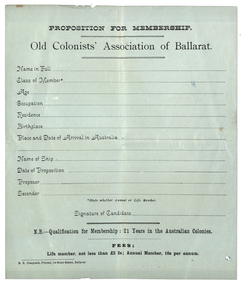 Old Colonists' Association of Ballarat Inc.
Document, E.E. Campbell, Proposition for Membership to the Old Colonists' Association of Ballarat, c1990
To qualify for membership of the Old Colonists' Association of Ballarat the potential member had to be 21 years in the Australian Colonies. This suggests the form was printed before the federation of Australian States in 1901.Printed form for potential Members of the Old Colonists' Association of Ballarat to fill out. The annual life membership fee was two pounds to shillings, and the annual member fee was 10 shillings per annum. Potential members were asked for the Name, Age, occupation, residence, birthplace, place and the of arrival in Australia, name of ship, date of propositions, proposer and seconder. old colonists' associaiton of ballarat, ballarat old colonists' club, membership form -
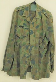 8th/13th Victorian Mounted Rifles Regimental Collection
Uniform - Cam Spinelli
Trooper M Spinelli of VMR Squadron 4th/19th Prince of Wales's Light Horse volunteered for full-time duty in 1999 and served with 2nd/14th Light Horse (Queensland Mounted Infantry) in East Timor as part of INTERFET. The International Force East Timor (INTERFET) was a multinational non-United Nations peacemaking task force, organised and led by Australia in accordance with United Nations resolutions to address the humanitarian and security crisis that took place in East Timor from 1999–2000 until the arrival of UN peacekeepers. INTERFET was commanded by an Australian military officer, Major General Peter Cosgrove.Camouflaged jacket and trousers with name panel above right breast pocket; plastic buttons.Spinelliinterfet, timor, spinelli, uniform, camouflage -
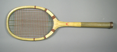 Tennis Australia
Racquet, Circa 1910
A 'Park' wooden tennis racquet with concave composite throat, string whipping in three places around shoulders, an octagonal handle with fine grooves, a leather end wrap and leather butt cap. Care instructions printed on end cap:WHEN NOT IN USE/PLEASE/KEEP IN A PRESS. Model name printed across throat. Materials: Wood, Lacquer, Metal, Glue, Gut, String, Leather, Inktennis -
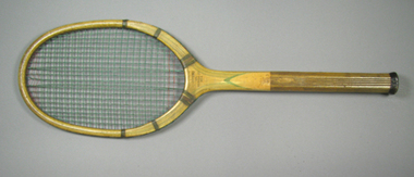 Tennis Australia
Racquet, Circa 1918
A J. S. Jeffreys tennis racquet with concave composite throat, an octagonal handle with both fine and medium grooves. String whipping in three places around each shoulder. Has a leather end wrap and butt cloth. Manufacturer/retailer name printed across throat on obverse. On butt cloth are printed care instructions (not completely decipherable). Materials: Wood, Lacquer, Metal, Glue, Gut, Leather, String, Cloth, Inktennis -
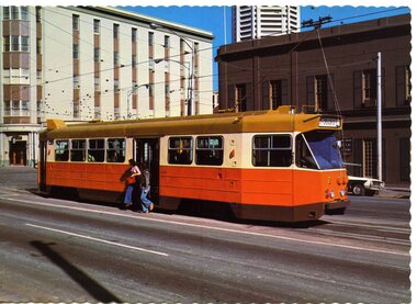 Ballarat Tramway Museum
Postcard, Nu-color-vue or Nucolorvue Productions, Spring St Melbourne
Colour postcard with serrated edges of MMTB Z class tram No. 2 in Spring St. Melbourne about to turn into Bourke St. Has two people stepping out of tram onto safety zone (no barriers). Tram has destination of "CITY - SPENCER ST." In background are the buildings of the Windsor Hotel, the Imperial Hotel and Nauru House. On rear of card is name of company "Nucolorvue" and caption "Melbourne Australia / Melbourne's new Z class tram Number 2.", card number NCV1419 in place for postage stamp, and copyright and symbols. See Destination City re introduction of Z class trams (1975)trams, tramways, spring st, melbourne, z class trams, tram 30, tram 25, tram 28, tram 5, tram 19 -
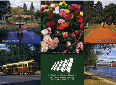 Ballarat Tramway Museum
Postcard, Rose Stereograph Co, "Ballarat Botanical Gardens by Lake Wendouree
Printed full colour postcard titled "Ballarat Botanical Gardens by Lake Wendouree Victoria Australia". Features photos of the Sensory Garden, Begonias, Prime Ministers Avenue, Lake Wendouree and No. 661, Wendouree Parade and Robert Clark centre logo. On rear is places for correspondence, stamp, barcode, address and rose image. Has the name of the publisher "Rose Stereograph Co. Glen Waverley Victoria" and name of photographers, Neil Cutts and Stephen Cutts". Rose Series No. 3620. trams, tramways, btm, wendouree parade, gardens, begonia festival, tram 26 -
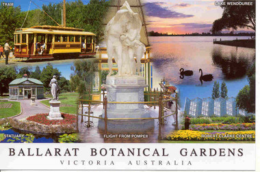 Ballarat Tramway Museum
Postcard, Rose Stereograph Co, "Ballarat Botanical Gardens Victoria Australia"
Printed full colour postcard titled "Ballarat Botanical Gardens Victoria Australia". Features photos of BTM No. 26, Lake Wendouree, Statuary, Flight from Pompeii and the Robert Clark Centre. On rear is places for correspondence, stamp, barcode, address and rose image. Has the name of the publisher "Rose Stereograph Co. Glen Waverley Victoria" and name of photographer, Stephen Cutts". Rose Series No. 4070. trams, tramways, btm, wendouree parade, gardens -
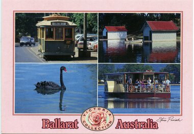 Ballarat Tramway Museum
Postcard, Steve Parish Publishing Pty Ltd, "Ballarat Australia" and "Victoria Collection", 2003
Printed full colour postcard titled "Ballarat Australia" and "Victoria Collection". Features photos of BTM No. 27, Lake Wendouree, black swan and paddle board. On rear is places for correspondence, stamp, barcode, address and publisher logo. Has the name of the publisher "Steve Parish" Steve Parish No. PC3036 and address details. trams, tramways, btm, wendouree parade, gardens, lake wendouree, swans -
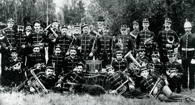 Bendigo Historical Society Inc.
Photograph - PETER ELLIS COLLECTION: NORTHCOTT'S CITY BAND
Mr. Northcott served all through the Crimean war, and obtained three service medals. He was most fortunate, as he did not even receive a scratch. While fighting in the trenches one day he happened to glance round, and was surprised to discover that his brother was by his side. They had not seen each other for a long time, and the meeting under such circumstances can be imagined. Two of his brothers, John and William, served throughout the war. At its close he came to Victoria, the gold fever being then at its height. His stay in Bendigo was brief, as the New Zealand rush attracted his attention, but he returned in 1858 to Bendigo, and as the outlook was quiet, he went back to New Zealand in 1859. Finally, in 1860, he settled in the Bendigo district with his father and mother and brother William. They took up some land at Leichardt and remained there for some years. It was about this time that he became prominent in musical circles. He came of a musical family, as his oldest brother, John, was one of the musicians to the Royal Family, and was pensioned by the late Queen Victoria. His younger brother, William, is at the present time one of the leading cornet players in the United States. In 1867 the late Mr. Northcott married Miss Lansell, sister of Mr. Geo. Lansell, her demise having taken place about three months before. When he left Leichardt, Mr. Northcott became Mr. Lansell's general manager, and continued in that capacity for 26 years. While he was manager of the 180 Mine it is estimated that gold to the value of a million sterling was taken from the mine. It is, perhaps, in his capacity as a bandsman, that Mr. Northcott was best known, as he became a familiar figure not only in the chief centres of Victoria but throughout Australia. He first became leader of the old Volunteer Band, and he was subsequently leader of the Battalion Band at Castlemaine. It was when he became leader of the musical combination known as Northcott's Brass Band that his fame and the fame of the band became widespread, as some 25 years ago it was one of the finest bands in Australia, and held that distinction for many years. Although many changes in the personnel of the band have taken place, it still retainsits old name. Mr. Northcott was a cornet player of high ability, and in 1871 he was presented by the citizens of Bendigo with a handsome silver cornet, in recognition of his services as a musician. His home contains a great array of trophies, photographic groups of bandsmen etc., which serve to indicate in a sense the reputation he enjoyed as a bandsman. During his career in Bendigo he invested in mining a good deal, but was not very fortunate in this respect, as he lost a good deal of money on the New Chum line. Naturally he was well known and warmly respected, especially by bandsmen. He was a genial citizen, and made a large circle of sincere friends. He was a member of the Zenith Lodge of Masons, having passed through the chairs twice. He was also a member of the A.O.F., and formerly a member of the School of Mines Administrative Council. It was about this time that he became prominent in musical circles. He came of a musical family, as his oldest brother, John, was one of the musicians to the Royal Family, and was pensioned by the late Queen Victoria. His younger brother, William, was one of the leading cornet players in the United States.Black and white photograph of Northcott's City Band, Bendigo. 3 rows of men in Band Uniform. Drum centre, brass instruments.men laying in grass at front.organisation, band, northcott's city band -
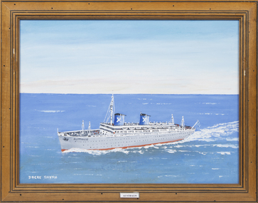 Queenscliffe Maritime Museum
Painting - SS Australis, Dacre Smyth, Australis
The Australis retains a significant place in Australian immigration history as the last ship to carry government assisted immigrants to Australian shores in 1977. She had the largest passenger capacity of any post World War II immigrant ship to regularly visit Australia and many passengers fondly remember her grandeur and remnants of Art Deco style.Mrs B SmythA framed oil painting of the migrant ship SS AustralisAustralisss australis, migrant ships -
 Bendigo Historical Society Inc.
Photograph - ANA Photograph Collage
The A.N.A. Hall in View Street was opened in August 1894. The Sandhurst Branch was started on August 26th, 1874. In July 1874, several gentlemen met together, and when a sufficient number had given in their names and sufficient promises of support had been received, the board of directors were approached with a view to forming a branch of the association in Bendigo. On August 26, 1874, the inception took place. The building was demolished in 1971. Photo collage of members of the Building Committee of the Sandhurst Branch of the Australian Natives' Association. Twenty sepia coloured photos recessed in oval or rectangular shaped opening with gold coloured edging, on backing board. One larger photo is surrounded by gold coloured pattern with scalloped edge. Below this is a photo of the ANA building in View Street. Banner beneath the Photo of the ANA building "Presented to Mr Chas. the Sandhurst Branch ANA in Recognition of His Valuable Service as President in Year 1894". The collage is framed in gold coloured ornate wooden frame. Plaque attached to lower edge of frame lists names of men in the photos. "BUILDING COMMITTEE - 1894" J H CURNOW M J CAHILL Dr J QUICK D A CAMPBELL M J E STAPLETON A DUNSTAN Dr J MURPHY C DALEY (President) A G DUNLOP W CROWLEY A J HAMPSON W BEEBE J HOGAN T GLASS J B YOUNG R H ABBOTT A.N.A. HALL A G DAYMOND D EGAN J DANIEL J BUCHAN S A COCK ana, australian natives' association, sandhurst, photo collage