Showing 314 items
matching planting plan
-
 Bendigo Historical Society Inc.
Document - THE SEA GOLD MINING AMALGAMATED COMPANY N. L. - NOTES ON THE SEA GOLD MINING
Carbon copy of notes on The Sea Gold Mining Amalgamated Company N. L. on the Garden Gully Line of Reef. Notes include size of lease, office, locality of shaft, sill and depth of shaft, plant, first & last crushing, Prominence, call and dividends, gold yield, best gold and underground connections. Signed by A Richards. Written at the top of page: Original to Mr R Leach, Manager, Allan's Music W'house.document, gold, the sea gold mining amal coy n l, the sea gold mining amalgamated company n. l., notes on the sea gold mining amalgamated company n. l., mccoll & rankin, mines dept plan 1937, annals of bendigo mining sections, g brown bendigo goldfield 1936, wood & mcnair s'brokers 1912, v pabst bendigo goldfields central area 1917, mines dept records, a richardson -
Bendigo Historical Society Inc.
Document - NORTH JOHNSONS MINE - NOTES ON THE NORTH JOHNSONS MINE
One typed, one handwritten and one handwritten carbon copy of notes on the North Johnsons Mine on the Garden Gully Line of Reef. Notes include size of lease (which was very small, only 83 yards along the line of reef, and the late 1890's absorbed the Rose of Denmark lease, the next mine north, of 57 yeards along the line of reef, Depth of shaft, height of Sill, Locality, Plant, Early History, Prominence, Best Gold, Total Gold Yield and Dividends,Underground Connections and References.document, gold, north johnsons mine, north johnsons mine, garden gully line of reef, rose of denmark, camerons reef, dagmar reef, johnsons no 1, johnsons no 2, special edition australian mining standard 1/6/1899, mines dept booklet bendigo goldfield geo brown 1936, mines dept quarterly and annual reports, annals of bendigo mining sections 1866 - 1917, a richardson, e j dunn's special report no 1 measurements taken from north johnsons mine transverse section 22/9/1892, wood & mcnair sharebrokers plan of leases of portion of bendigo goldfield to 4/5/1912 -
 Bendigo Historical Society Inc.
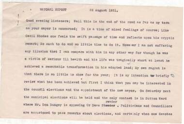
Document - NORMAN OLIVER COLLECTION: SPEECH NOTES 22 AUGUST 1951
The Norman Oliver collection. Norman Oliver was three times Mayor of Bendigo - 1950-51, 1964-65, 1970-71. Sixteen pages of typed notes headed Mayoral Report 22 August 1951. Corrections in blue ink. In the format he used for his talks on 3BO 'The Mayor Speaks'. The last report for his first Mayoral term. Topics include : the Year's work - land reclamation, the loan for earth moving plant, garbage disposal, sports grounds, drainage, Sewerage Authority, the saleyards, the Aerodrome, Housing, and the Bendigo Creek and town planning.bendigo, council, speech notes, norman joseph oliver , councillor norman oliver. mayor of bendigo. 3bo 'the mayor speaks'. -
Bendigo Historical Society Inc.
Document - STATE RIVERS AND WATER SUPPLY COMMISSION : GENERAL DESCRIPTION AND PARTICULARS OF EPPALOCK PROJECT, 1/08/1961
State Rivers and Water Supply Commission. Seven page typed document titled 'General description and particulars of the Eppalock Project.' Subheadings: General, Administration and Works Installation, Field laboratory, Construction programme, Design statistics, Major items of plant in use on the project, Progress to 1st August 1961, Eppalock Reservoir Locality Plan (diagram), Eppalock project works area & arrangement plan (diagram), Eppalock Project cross section of dam along? tunnel (diagram).state infrastructure, water supply, coliban system, state rivers and water supply commission. coliban system. eppalock. -
 Bendigo Historical Society Inc.
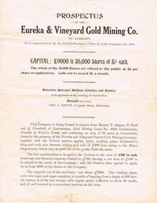
Document - JOSEPH DAVIES COLLECTION: PROSPECTUS OF THE EUREKA & VINEYARD GOLD MINING CO. N. L, 1900's
Printed Prospectus of the Eureka & Vineyard Gold Mining Co. N. L. Prospectus mentions previous owners, cost and capability of machinery, plans for working, yields, and mentions full reports photographs of plant and reef outcrop are at the office. Also mentioned are the price of shares and Calls not to exceed 3d a month.document, certificate, shares, joseph davies collection - prospectus of the eureka & vineyard gold mining co nl, geo j keogh, t odgers, b ford, q crawford, gold mining lease no 4430, mines department, vineyard reef, eureka reef -
 Bendigo Historical Society Inc.
Document - DEBORAH REEF PROJECT ENVIRONMENT EFFECTS STATEMENT
Two page document. On top, first page ' Bendigo Mining N.L., Deborah Reef Project, Environment Effects Statement, Summary Brochure'. Poppet head on top LH corner of document. A map of central Bendigo is drawn on page 1 and shows the location of the proposed processing plant near the Airport. Further maps on page 2 and 3 show the North Deborah Mine Site, the pipeline route and the airfield site. The summary brochure provides an outline of the material contained in the Environment Effects Statement and proposed planning scheme amendments upon which, the Deborah Reef Project will be assessed. Page four lists the issues that impact on this submission: planning and land use; socio economic environment; traffic; discharges to air; water management; explosives storage and handling; subsidence; heritage; flora and fauna and landscape and visual assessment. The 16th March, 1989, is the date given for submissions to be lodged in regard to this project.Bendigo Mining N.Lbendigo, mining, deborah reef project -
Bendigo Historical Society Inc.
Document - HERCULES AND ENERGETIC MINES - NOTES ON THE HERCULES AND ENERGETIC MINES
Four typed copies of notes on the Hercules and Energetic Mines. Notes include Location, depth of shafts, plant and machinery, Early History and Prominence. Reference: Mines Dept Special Edition Australian Mining Standard 1.6.1899, Mines Dept Booklet Bendigo Goldfield 1936, Mines Dept Annual and Quarterly Reports, Annals of Bendigo Mining Sections 1876 - 1921, A Richardson, The Bendigo Goldfield Registry J N Macartney 1.3.1871, Mines Dept Bulletin No 30 h Herman 1914, Bendigo Amalgamated Goldfields Coy Financial Reports 1920.mine, gold, hercules and energetic mines, hercules and energetic mines, notes on the hercules and energetic mines, the hercules, the energetic, the north energetic, the victoria pilot, plan of leases of 1870, bendigo amalgamated goldfields company, sheepshead line, wheat owl, central blue, big blue, mines dept special edition australian mining standard 1.6.1899, mines dept booklet bendigo goldfield 1936, mines dept annual and quarterly reports, annals of bendigo mining sections 1876 - 1921, a richardson, the bendigo goldfield registry j n macartney 1.3.1871, mines dept bulletin no 30 h herman 1914, bendigo amalgamated goldfields coy financial reports 1920 -
Bendigo Historical Society Inc.
Document - LANSELL'S BIG 180 MINE - CONDENSED HISTORICAL RECORD OF LANSELL'S BIG 180 MINE
Two handwritten and three typed copies of a Condensed Historical Record of Lansell's Big 180 Mine on the New Chum Line of Reef. Notes include location, shaft, first worked, size of lease, plant, engine house, boiler rooms, mullock heap, early history, Prominent, best gold, underground connections, pressurised hot water, diamond drill bores and a table with depths and the increase in temperature with the depth (in Fahr).document, gold, lansell's big 180 mine, lansell's big 180 mine, condensed historical record of lansell's big 180 mine, wittscheibe, ballerstadt, ernst mueller, theodore ballerstadt, george lansell, north old chum, victoria quartz, mines dept special edition 'australian mining standard' 1/6/1899, mines dept booklet 'bendigo goldfield' 1936, quarterly reports, lansell's 180 mine 'transverse sections, annals of bendigo mining sections, a richardson's observations from old photographs and measurements of mining plans, measurements taked from caleb thomas' report mines dept 1875, 'report on observation of underground temperature at bendigo' james stirling government geologist 1899, a richardson -
 Bendigo Historical Society Inc.
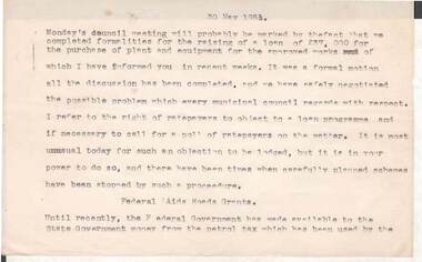
Document - NORMAN OLIVER COLLECTION: SPEECH NOTES 30 MAY 1951
The Norman Oliver collection. Norman Oliver was three times Mayor of Bendigo - 1950-51, 1964-65, 1970-71. Nineteen pages of typed notes dated 30 May 1951. In the format of his weekly talk on 3BO 'The Mayor Speaks'. Topics include : announcement of a loan for 37,000 pounds for plant and equipment, Federal Aids Roads Grants, traffic lights, taxi services, hackney carriage licenses, South Bendigo Football Club, the School for Deaf Children, the engineer's report, town planning, the Baby Health Centre.bendigo, council, speech notes, norman joseph oliver , councillor norman oliver. mayor. 3bo 'the mayor speaks'. school for deaf children. -
 Bendigo Historical Society Inc.
Document - MCCOLL, RANKIN AND STANISTREET COLLECTION: NEW SOUTH MOON MINE - BATTERY PLANT, 1942
Document; Folder with documents about purchase of Battery Plant by North Virginia Co. & East Clarence Co. Supply agreement for electricity, correspondence, plans showing where battery to be installed.east Clarence Gold Mining Co. North Virginia Gold Mining Co. re purchase of battery.MCCOLL RANKIN & STANISTREETorganization, business, mining equipment, mccoll rankin & stanistreet -
Port Melbourne Historical & Preservation Society
Plant specimen - Branch, Port Jackson fig tree, Holy Trinity Anglican Church, Dec 1999
The tree was chopped down December 1999 in spite of local opposition, to make way for a planned development of the church hall. The application was refused by Port Phillip Council but approved by VCAT in a contentious decision. There was conflicting advice about the health of this tree which at that time enjoyed no protection under the planning scheme. Local landscape architect, Ray PICKFORD, landscape architect and owner (at that time) of Morley's house at cnr Farrell and Nott St, was so distressed by this action that he stripped in an attempt to generate media attention. Subsequently, ward councillor Julian HILL purchased a portion of the timber from a wood recycler and it was re-made into timber benches for the refurbished Port Melbourne Library.Portion of branch from Port Jackson fig located in the grounds of the Holy Trintiy Church Hall, demolished December 1999 (Ref 1421)religion - anglican (holy trinity), built environment, demolitions -
Port Melbourne Historical & Preservation Society
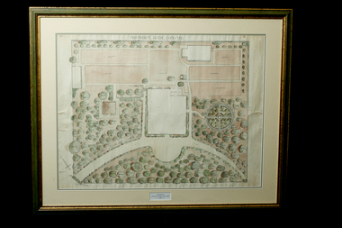
Plan, B A Carter, Land Plan Primary School 1427 Port Melb, c. 1975
The design for extensive planting and landscaping of Nott Street Primary School, Port MelbournePlan of Landscape design for Nott Street Primary School, Port Melbourne.education - primary schools, nott street primary school -
 Cockatoo History & Heritage Group
Landscape Plan, Providence House Cockatoo, 1930's
The Presbyterian Church owned three lots of land bounded by Pakenham Road and the northern side of Dorchester Road, between 1927 and 1964. Providence House opened in 1927 as a peaceful country rest home for “tired mothers” from the inner suburbs, and their children. It was also used, at different times, for kindergarten groups and in 1955 for a girls Bible Class for Easter “studies, fun and fellowship.”Cockatoo had several guest houses which took paying guests. Providence House did not charge fees, but is the best-documented of the large houses which provided accommodation.Framed landscape design plan under glass, with detailed plant listings. Original watercolourDonated by Victoria & Digby Newcombe 2003presbyterian church, rest home, landscape plan, garden design, cockatoo victoria, providence house, black n.c, -
University of Melbourne, Burnley Campus Archives
Document - Register, University of Melbourne (Burnley Campus)-Grassy Woodland Plant List, c.1990
... tulk native grassland water garden plans (1) List of plants ...(1) List of plants established in the grassland (by number but no plan) compiled by Chris Findlay and Phil Tulk. (2) Burnley Native Grassland Plant List, numerical order (no plan) and alphabetical order , not the same as (1). Stored with Plans of Water Garden.plants, grassland, chris findlay, phil tulk, native grassland, water garden, plans -
 Hume City Civic Collection
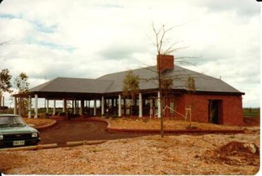
Photograph, 1/10/1978
On 4th August 1978 the construction of the Goonawarra Housing Estate commenced. The estate was formerly known as the Goonawarra Farm and overloked the Sunbury town area and Jacksons Creek valley. Plans for the new development included a gold course, housing, community and recreational facilities. The construction continued througout the last two decades of the twentieth century and into the twenty first century.A coloured photograph of the clubhouse taken from the south west at the Goonawarra Golf Club. The surrounding garden has been planted out with trees and has been mulched. A green car is on the LHS of the photograph.goonawarra farm, goonawarra golf club, goonawarra housing estate, sharkey, robert b., kilkenny homes, australian ideas homes pty.ltd., craftsmen homes., glamor homes, villa bella homes, george evans collection -
 University of Melbourne, Burnley Campus Archives
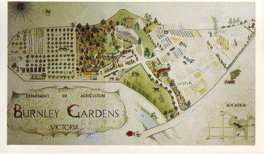
Slide - Colour slide, Milton Gellert, Department of Agriculture Burnley Gardens Victoria, 1955-1990
Copied for use as a postcard for the Centennial Year in 1990. Note by T.H. Kneen 18 March 1992, "The original drawing was done by Milton Gellert and for a considerable time was displayed in the Fruit Preserving Branch's display window. This was Milton's own concept and was probably done in late 50's. Milton was on Burnley Staff 1955-57 & then employed at Plant Research Institute, Burnley Gardens." The picture was later hung in the Staff Room in the Administration Building but has disappeared.2 copies, large colour negative. Coloured hand drawn plan of of the whole site in a frame. Photographed in 1965.centennial year, milton gellert, fruit preserving branch, staff, plant research institute, burnley gardens, hand drawn plan of site, 1991, plan -
 National Wool Museum
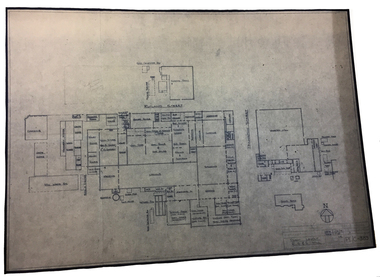
Archive - Architectural Plan, Plant Layout: R S & S Mill, 1973
Site plan of the R S & S Mill, 1st Dec, 1973.Architectural drawing on paper showing hand written diagrams and text. PE/C - 389textile mills - design textile mills - history, textile mills - design, textile mills - history, returned soldiers and sailors mill, r s & s mill, architecture, plan, site plan -
Stawell Historical Society Inc
Archive - Document, Specification Documents Stawell hospital, 1933- 1980
1933 - 1980 -1 Specifications New Hospital - 2 Specification of Excavation and Leveling. Febuary 1933 - 3 Specification of Enterane roadway. November 1933 - 4 Specifications Alterations and Additions. June 1940 - 5 Specification Repairs and External Painting - June 1940. Plus some tender application Letters - 6 Specifactions New Brick and Timber Linen Store. January 1943 - 7 New Nursing Home Construction - Bills of Quantities and Estimates August 1954 - 8 Specifactions for Building nurses Home - 9 Specifactions New work Alterationsto service Rooms. April 1955 - 10 Specifactions Nurses Home ( Timber Balustrades & Brick Retaining wall.) June 1956 - 11 Specifactions Labour and Materials Erecetion and Completion of Additions to Matron's Flat. August 1964 - 12 Specifactions of Work to be done and Materials to be use din Remodelling and Additions. October 1965. - 13 Specifaction for Supply & Installation of Hot Water, Heating & Air Conditioning Plant New Theatre Wing. November 1965 - 14 Specifaction of Remodelling and Additions at Stawell. New Geriatric Ward. November 1971 - 15 Specifactions of Electical Services at New Geriatric Ward November 1971 - 16 Specifaction for building works for Geriatric Day Centre Wing c1975 - 17 Specification Geriatric Day Centre Electrical Service. March 1975 - 18 Plans and Specifications for construction of Parking areas and Widening Existing Accress Road. April 1979 - 19 Specifications of Electrical Services for Lighting installations. January 1980 PLANS - 20 Male barthroom. July 1964 - 21 Additions to Matrons Flat - 22 Alteration Sketch Plan. June 1962 - 23 Approach to Sloane Street. September 1933 - 24 Hobart Food Services AM12 Series Washer pamphlet. - 25 Hospital Appeal Correspondance. October 1963.hospital -
Whitehorse Historical Society Inc.
Pamphlet, Creating a living environment
Booklet on the guidelines for building, siting and design in residential areas of the City of Nunawading by the City of Nunawading Planning Department.Booklet on the guidelines for building, siting and design in residential areas of the City of Nunawading by the City of Nunawading Planning Department.Booklet on the guidelines for building, siting and design in residential areas of the City of Nunawading by the City of Nunawading Planning Department.town planning, city of nunawading, native plants -
Whitehorse Historical Society Inc.
Document, Ellis Stone's medisan planting, 1/05/2001 12:00:00 AM
'Ellis Stones' median planting, Canterbury Road, Vermont.'Ellis Stones' median planting, Canterbury Road, Vermont. Brochure describing median strip landscaping in Canterbury Road, Vermont undertaken by Ellis Stones in 1974 and details of proposed replanting.'Ellis Stones' median planting, Canterbury Road, Vermont. stones, ellis, canterbury road, vermont, roads and streets, landscape planning, city of whitehorse -
Whitehorse Historical Society Inc.
Article, Trader wants native trees for mall, 1991
Trader, Russ Alexander, of Mitcham Shopping Centre, thinks that the trees planted in Mitcham Mall should be indigenous. The Council has no policy on planting indigenous trees.Trader, Russ Alexander, of Mitcham Shopping Centre, thinks that the trees planted in Mitcham Mall should be indigenous. The Council has no policy on planting indigenous trees. Les Smith, Vice president of Blackburn and District Tree Preservation Society, says he will write to Council and check on the original plans.Trader, Russ Alexander, of Mitcham Shopping Centre, thinks that the trees planted in Mitcham Mall should be indigenous. The Council has no policy on planting indigenous trees. shopping centres, mitcham shopping centre, alexander, russell, blackburn and district tree preservation society, smith, les -
Whitehorse Historical Society Inc.
Document, Nunawading South State School
... Plan. Notice from Native Plants Preservation Society.... and during building. Road Plan. Notice from Native Plants ...Documents relating to purchase of land to build Nunawading South State School. Land purchased from K.E. & L.A. Jones. Photocopies of photos of the land before and during building. Road Plan. Notice from Native Plants Preservation Society.nunawading south state school no. 4808, k.e. & l.a. jones, victoria. education department, native plants preservation society of victoria -
Whitehorse Historical Society Inc.
Document, Yarran Dheran, 4/07/1969
A report on the establishment of a native plant reserve in the City of Nunawading. Includes detailed proposed development plans.native plants, yarran dheran -
 Whitehorse Historical Society Inc.
Report, A Report on the Development of Yarran Dheran, 1/05/1985 12:00:00 AM
Report by a landscape designer, Paul Thompson, on Yarran Dheran as it was in 1985 and its development in terms of the 1974 master plan. Various areas are discussed in detail. Also includes a summary of the Master Plan. Lists of weeds. Recommendations of appropriate plants for various zones. 22p.yarran dheran, native plants, weeds, parks and reserves -
 Whitehorse Historical Society Inc.
Work on paper - Report, The Vegetation, fauna and management of Antonio Park, City of Nunawading, Victoria, 1/10/1987 12:00:00 AM
Photocopy of a detailed report prepared for the Nunawading City Council on the vegetation, fauna and management of Antonio Park.Photocopy of a detailed report prepared for the Nunawading City Council on the vegetation, fauna and management of Antonio Park. Lists of 320 plant species were made. A broad indigenous community: 'Grassy Open Forest' is described. Lists of butterflies, reptiles, birds and mammals. Weed infestation and degradation processes are identified. A range of management issues are identified and recommendations made. ca 120 pages. Photographs. Plans.Photocopy of a detailed report prepared for the Nunawading City Council on the vegetation, fauna and management of Antonio Park.antonio park, mitcham, animals, native plants, birds, wildlife -
 Whitehorse Historical Society Inc.
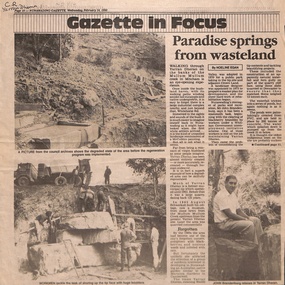
Newspaper - Article, Paradise springs from wasteland, 14/02/1990
A landscape designer was appointed in 1993 to prepare a master plan after which the mammoth task of clearing and planting was undertaken and koalas and sugar-gliders introduced. Information Centre built.parks and reserves, brandenburg, john p, yarran dheran, mullum mullum creek, smith, dorothy g., koalas, sugar gliders, schwerkolt, johann august -
 Whitehorse Historical Society Inc.
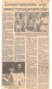
Article, Conservationists to urge weed management plan, 5/04/1989 12:00:00 AM
Article from Nunawading Gazette dated 5 April 1989 about a weed management plan in the City of Nunawading.environment, weeds, victoria. department of conservation, forests and lands., native plants, edwards, margaret, meagher, dorothy, witherspoon, cameron, david -
 Ballarat Heritage Services
Photograph - Digital photographs, L.J. Gervasoni, Boroondara General Cemetery Gatehouse, c2005-2015
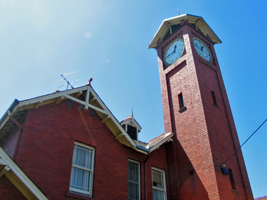
The Boroondara General Cemetery is registerd by Heritage VictoriaBoroondara Cemetery in kew was established in 1858. It has an unusual triangular reserve bounded by High Street, Park Hill Road and Victoria Park, Kew. The caretaker's lodge and administrative office (1860 designed by Charles Vickers, additions, 1866-1899 by Albert Purchas) form a picturesque two-storey brick structure with a slate roof and clock tower. A rotunda or shelter (1890, Albert Purchas) is located in the centre of the cemetery: this has an octagonal hipped roof with fish scale slates and a decorative brick base with a tessellated floor and timber seating. The cemetery is surrounded by a 2.7 metre high ornamental red brick wall (1895-96, Albert Purchas) with some sections of vertical iron palisades between brick pillars. Albert Purchas was a prominent Melbourne architect who was the Secretary of the Melbourne General Cemetery from 1852 to 1907 and Chairman of the Boroondara Cemetery Board of Trustees from 1867 to 1909. He made a significant contribution to the design of the Boroondara Cemetery Boroondara Cemetery is an outstanding example of the Victorian Garden Cemetery movement in Victoria, retaining key elements of the style, despite overdevelopment which has obscured some of the paths and driveways. Elements of the style represented at Boroondara include an ornamental boundary fence, a system of curving paths which are kerbed and follow the site's natural contours, defined views, recreational facilities such as the rotunda, a landscaped park like setting, sectarian divisions for burials, impressive monuments, wrought and cast iron grave surrounds and exotic symbolic plantings. In the 1850s cemeteries were located on the periphery of populated areas because of concerns about diseases like cholera. They were designed to be attractive places for mourners and visitors to walk and contemplate. Typically cemeteries were arranged to keep religions separated and this tended to maintain links to places of origin, reflecting a migrant society. Other developments included cast iron entrance gates, built in 1889 to a design by Albert Purchas; a cemetery shelter or rotunda, built in 1890, which is a replica of one constructed in the Melbourne General Cemetery in the same year; an ornamental brick fence erected in 1896-99(?); the construction and operation of a terminus for a horse tram at the cemetery gates during 1887-1915; and the Springthorpe Memorial built between 1897 and 1907. A brick cremation wall and a memorial rose garden were constructed near the entrance in the mid- twentieth century(c.1955-57) and a mausoleum completed in 2001.The maintenance shed/depot close to High Street was constructed in 1987. The original entrance was altered in 2000 and the original cast iron gates moved to the eastern entrance of the Mausoleum. Some notable memorials include The Springthorpe Memorial (VHR 522), The Syme Memorial (1908), The Cussen Memorial (VHR 2036). Burials within the cemetery include the Henty family, artists Louis Buvelot and Charles Nuttall, businessmen John Halfey and publisher David Syme, artist and diarist Georgiana McCrae, actress Nellie Stewart and architect and designer of the Boroondara and Melbourne General Cemeteries, Albert Purchas. The Boroondara Cemetery features many plants, mostly conifers and shrubs of funerary symbolism, which line the boundaries, road and pathways, and frame the cemetery monuments or are planted on graves. The major plantings include an impressive row of Bhutan Cypress (Cupressus torulosa), interplanted with Sweet Pittosporum (Pittosporum undulatum), and a few Pittosporum crassifolium, along the High Street and Parkhill Street, where the planting is dominated by Sweet Pittosporum. Planting within the cemetery includes rows and specimen trees of Bhutan Cypress and Italian Cypress (Cupressus sempervirens), including a row with alternate plantings of both species. The planting includes an unusual "squat" form of an Italian Cypress. More of these trees probably lined the cemetery roads and paths. Also dominating the cemetery landscape near the Rotunda is a stand of 3 Canary Island Pines (Pinus canariensis), a Bunya Bunya Pine (Araucaria bidwillii) and a Weeping Elm (Ulmus glabra 'Camperdownii'). Amongst the planting are the following notable conifers: a towering Bunya Bunya Pine (Araucaria bidwillii), a Coast Redwood (Sequoia sempervirens), a rare Golden Funeral Cypress (Chamaecyparis funebris 'Aurea'), two large Funeral Cypress (Chamaecyparis funebris), and the only known Queensland Kauri (Agathis robusta) in a cemetery in Victoria. The Cemetery records, including historical plans of the cemetery from 1859, are held by the administration and their retention enhances the historical significance of the Cemetery. Digital images of a red brick gatehouse at Boroondara General Cemetery in Kew.cemetery, boroondara, kew, gatehouse, clock, tower, clocktower, heritage, memorial -
 Ballarat Heritage Services
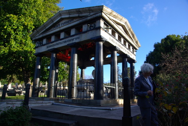
Photograph - Digital photographs, L.J. Gervasoni, Boroondara General Cemetery Springthorpe Memorial, c2005-2015
The Boroondara General Cemetery is registerd by Heritage VictoriaFrom Heritage Victoria Statement of Significance Last updated on - December 15, 2005 What is significant? Boroondara Cemetery, established in 1858, is within an unusual triangular reserve bounded by High Street, Park Hill Road and Victoria Park, Kew. The caretaker's lodge and administrative office (1860 designed by Charles Vickers, additions, 1866-1899 by Albert Purchas) form a picturesque two-storey brick structure with a slate roof and clock tower. A rotunda or shelter (1890, Albert Purchas) is located in the centre of the cemetery: this has an octagonal hipped roof with fish scale slates and a decorative brick base with a tessellated floor and timber seating. The cemetery is surrounded by a 2.7 metre high ornamental red brick wall (1895-96, Albert Purchas) with some sections of vertical iron palisades between brick pillars. Albert Purchas was a prominent Melbourne architect who was the Secretary of the Melbourne General Cemetery from 1852 to 1907 and Chairman of the Boroondara Cemetery Board of Trustees from 1867 to 1909. He made a significant contribution to the design of the Boroondara Cemetery Boroondara Cemetery is an outstanding example of the Victorian Garden Cemetery movement in Victoria, retaining key elements of the style, despite overdevelopment which has obscured some of the paths and driveways. Elements of the style represented at Boroondara include an ornamental boundary fence, a system of curving paths which are kerbed and follow the site's natural contours, defined views, recreational facilities such as the rotunda, a landscaped park like setting, sectarian divisions for burials, impressive monuments, wrought and cast iron grave surrounds and exotic symbolic plantings. In the 1850s cemeteries were located on the periphery of populated areas because of concerns about diseases like cholera. They were designed to be attractive places for mourners and visitors to walk and contemplate. Typically cemeteries were arranged to keep religions separated and this tended to maintain links to places of origin, reflecting a migrant society. Other developments included cast iron entrance gates, built in 1889 to a design by Albert Purchas; a cemetery shelter or rotunda, built in 1890, which is a replica of one constructed in the Melbourne General Cemetery in the same year; an ornamental brick fence erected in 1896-99(?); the construction and operation of a terminus for a horse tram at the cemetery gates during 1887-1915; and the Springthorpe Memorial built between 1897 and 1907. A brick cremation wall and a memorial rose garden were constructed near the entrance in the mid- twentieth century(c.1955-57) and a mausoleum completed in 2001.The maintenance shed/depot close to High Street was constructed in 1987. The original entrance was altered in 2000 and the original cast iron gates moved to the eastern entrance of the Mausoleum. The Springthorpe Memorial (VHR 522) set at the entrance to the burial ground commemorates Annie Springthorpe, and was erected between 1897 and 1907 by her husband Dr John Springthorpe. It was the work of the sculptor Bertram Mackennal, architect Harold Desbrowe Annear, landscape designer and Director of the Melbourne Bortanic Gardens, W.R. Guilfoyle, with considerable input from Dr Springthorpe The memorial is in the form of a small temple in a primitive Doric style. It was designed by Harold Desbrowe Annear and includes Bertram Mackennal sculptures in Carrara marble. Twelve columns of deep green granite from Scotland support a Harcourt granite superstructure. The roof by Brooks Robinson is a coloured glass dome, which sits within the rectangular form and behind the pediments. The sculptural group raised on a dais, consists of the deceased woman lying on a sarcophagus with an attending angel and mourner. The figure of Grief crouches at the foot of the bier and an angel places a wreath over Annie's head, symbolising the triumph of immortal life over death. The body of the deceased was placed in a vault below. The bronze work is by Marriots of Melbourne. Professor Tucker of the University of Melbourne composed appropriate inscriptions in English and archaic Greek lettering.. The floor is a geometric mosaic and the glass dome roof is of Tiffany style lead lighting in hues of reds and pinks in a radiating pattern. The memorial originally stood in a landscape triangular garden of about one acre near the entrance to the cemetery. However, after Dr Springthorpe's death in 1933 it was found that transactions for the land had not been fully completed so most of it was regained by the cemetery. A sundial and seat remain. The building is almost completely intact. The only alteration has been the removal of a glass canopy over the statuary and missing chains between posts. The Argus (26 March 1933) considered the memorial to be the most beautiful work of its kind in Australia. No comparable buildings are known. The Syme Memorial (1908) is a memorial to David Syme, political economist and publisher of the Melbourne Age newspaper. The Egyptian memorial designed by architect Arthur Peck is one of the most finely designed and executed pieces of monumental design in Melbourne. It has a temple like form with each column having a different capital detail. These support a cornice that curves both inwards and outwards. The tomb also has balustradings set between granite piers which create porch spaces leading to the entrance ways. Two variegated Port Jackson Figs are planted at either end. The Cussen Memorial (VHR 2036) was constructed in 1912-13 by Sir Leo Cussen in memory of his young son Hubert. Sir Leo Finn Bernard Cussen (1859-1933), judge and member of the Victorian Supreme Court in 1906. was buried here. The family memorial is one of the larger and more impressive memorials in the cemetery and is an interesting example of the 1930s Gothic Revival style architecture. It takes the form of a small chapel with carvings, diamond shaped roof tiles and decorated ridge embellishing the exterior. By the 1890s, the Boroondara Cemetery was a popular destination for visitors and locals admiring the beauty of the grounds and the splendid monuments. The edge of suburban settlement had reached the cemetery in the previous decade. Its Victorian garden design with sweeping curved drives, hill top views and high maintenance made it attractive. In its Victorian Garden Cemetery design, Boroondara was following an international trend. The picturesque Romanticism of the Pere la Chaise garden cemetery established in Paris in 1804 provided a prototype for great metropolitan cemeteries such as Kensal Green (1883) and Highgate (1839) in London and the Glasgow Necropolis (1831). Boroondara Cemetery was important in establishing this trend in Australia. The cemetery's beauty peaked with the progressive completion of the spectacular Springthorpe Memorial between 1899 and 1907. From about the turn of the century, the trustees encroached on the original design, having repeatedly failed in attempts to gain more land. The wide plantations around road boundaries, grassy verges around clusters of graves in each denomination, and most of the landscaped surround to the Springthorpe memorial are now gone. Some of the original road and path space were resumed for burial purposes. The post war period saw an increased use of the Cemetery by newer migrant groups. The mid- to late- twentieth century monuments were often placed on the grassed edges of the various sections and encroached on the roadways as the cemetery had reached the potential foreseen by its design. These were well tended in comparison with Victorian monuments which have generally been left to fall into a state of neglect. The Boroondara Cemetery features many plants, mostly conifers and shrubs of funerary symbolism, which line the boundaries, road and pathways, and frame the cemetery monuments or are planted on graves. The major plantings include an impressive row of Bhutan Cypress (Cupressus torulosa), interplanted with Sweet Pittosporum (Pittosporum undulatum), and a few Pittosporum crassifolium, along the High Street and Parkhill Street, where the planting is dominated by Sweet Pittosporum. Planting within the cemetery includes rows and specimen trees of Bhutan Cypress and Italian Cypress (Cupressus sempervirens), including a row with alternate plantings of both species. The planting includes an unusual "squat" form of an Italian Cypress. More of these trees probably lined the cemetery roads and paths. Also dominating the cemetery landscape near the Rotunda is a stand of 3 Canary Island Pines (Pinus canariensis), a Bunya Bunya Pine (Araucaria bidwillii) and a Weeping Elm (Ulmus glabra 'Camperdownii') Amongst the planting are the following notable conifers: a towering Bunya Bunya Pine (Araucaria bidwillii), a Coast Redwood (Sequoia sempervirens), a rare Golden Funeral Cypress (Chamaecyparis funebris 'Aurea'), two large Funeral Cypress (Chamaecyparis funebris), and the only known Queensland Kauri (Agathis robusta) in a cemetery in Victoria. The Cemetery records, including historical plans of the cemetery from 1859, are held by the administration and their retention enhances the historical significance of the Cemetery. How is it significant? Boroondara Cemetery is of aesthetic, architectural, scientific (botanical) and historical significance to the State of Victoria. Why is it significant? The Boroondara Cemetery is of historical and aesthetic significance as an outstanding example of a Victorian garden cemetery. The Boroondara Cemetery is of historical significance as a record of Victorian life from the 1850s, and the early settlement of Kew. It is also significant for its ability to demonstrate, through the design and location of the cemetery, attitudes towards burial, health concerns and the importance placed on religion, at the time of its establishment. The Boroondara Cemetery is of architectural significance for the design of the gatehouse or sexton's lodge and cemetery office (built in stages from 1860 to 1899), the ornamental brick perimeter fence and elegant cemetery shelter to the design of prominent Melbourne architects, Charles Vickers (for the original 1860 cottage) and Albert Purchas, cemetery architect and secretary from 1864 to his death in 1907. The Boroondara Cemetery has considerable aesthetic significance which is principally derived from its tranquil, picturesque setting; its impressive memorials and monuments; its landmark features such as the prominent clocktower of the sexton's lodge and office, the mature exotic plantings, the decorative brick fence and the entrance gates; its defined views; and its curving paths. The Springthorpe Memorial (VHR 522), the Syme Memorial and the Cussen Memorial (VHR 2036), all contained within the Boroondara Cemetery, are of aesthetic and architectural significance for their creative and artistic achievement. The Boroondara Cemetery is of scientific (botanical) significance for its collection of rare mature exotic plantings. The Golden Funeral Cypress, (Chamaecyparis funebris 'Aurea') is the only known example in Victoria. The Boroondara Cemetery is of historical significance for the graves, monuments and epitaphs of a number of individuals whose activities have played a major part in Australia's history. They include the Henty family, artists Louis Buvelot and Charles Nuttall, businessmen John Halfey and publisher David Syme, artist and diarist Georgiana McCrae, actress Nellie Stewart and architect and designer of the Boroondara and Melbourne General Cemeteries, Albert Purchas.Digital image of the Springthorpe Memorial in the Boroondara General Cemeterycemetery, boroondara, kew, gatehouse, clock, tower, clocktower, heritage, memorial, springthorpe memorial -
 Ballarat Heritage Services
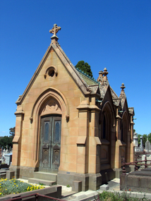
Photograph - Digital photographs, Cussen Memorial in the Boroondara General Cemetery, Kew, Victoria, c2005-2015
The Boroondara General Cemetery is registerd by Heritage VictoriaFrom Heritage Victoria Statement of Significance Last updated on - December 15, 2005 What is significant? Boroondara Cemetery, established in 1858, is within an unusual triangular reserve bounded by High Street, Park Hill Road and Victoria Park, Kew. The caretaker's lodge and administrative office (1860 designed by Charles Vickers, additions, 1866-1899 by Albert Purchas) form a picturesque two-storey brick structure with a slate roof and clock tower. A rotunda or shelter (1890, Albert Purchas) is located in the centre of the cemetery: this has an octagonal hipped roof with fish scale slates and a decorative brick base with a tessellated floor and timber seating. The cemetery is surrounded by a 2.7 metre high ornamental red brick wall (1895-96, Albert Purchas) with some sections of vertical iron palisades between brick pillars. Albert Purchas was a prominent Melbourne architect who was the Secretary of the Melbourne General Cemetery from 1852 to 1907 and Chairman of the Boroondara Cemetery Board of Trustees from 1867 to 1909. He made a significant contribution to the design of the Boroondara Cemetery Boroondara Cemetery is an outstanding example of the Victorian Garden Cemetery movement in Victoria, retaining key elements of the style, despite overdevelopment which has obscured some of the paths and driveways. Elements of the style represented at Boroondara include an ornamental boundary fence, a system of curving paths which are kerbed and follow the site's natural contours, defined views, recreational facilities such as the rotunda, a landscaped park like setting, sectarian divisions for burials, impressive monuments, wrought and cast iron grave surrounds and exotic symbolic plantings. In the 1850s cemeteries were located on the periphery of populated areas because of concerns about diseases like cholera. They were designed to be attractive places for mourners and visitors to walk and contemplate. Typically cemeteries were arranged to keep religions separated and this tended to maintain links to places of origin, reflecting a migrant society. Other developments included cast iron entrance gates, built in 1889 to a design by Albert Purchas; a cemetery shelter or rotunda, built in 1890, which is a replica of one constructed in the Melbourne General Cemetery in the same year; an ornamental brick fence erected in 1896-99(?); the construction and operation of a terminus for a horse tram at the cemetery gates during 1887-1915; and the Springthorpe Memorial built between 1897 and 1907. A brick cremation wall and a memorial rose garden were constructed near the entrance in the mid- twentieth century(c.1955-57) and a mausoleum completed in 2001.The maintenance shed/depot close to High Street was constructed in 1987. The original entrance was altered in 2000 and the original cast iron gates moved to the eastern entrance of the Mausoleum. The Springthorpe Memorial (VHR 522) set at the entrance to the burial ground commemorates Annie Springthorpe, and was erected between 1897 and 1907 by her husband Dr John Springthorpe. It was the work of the sculptor Bertram Mackennal, architect Harold Desbrowe Annear, landscape designer and Director of the Melbourne Bortanic Gardens, W.R. Guilfoyle, with considerable input from Dr Springthorpe The memorial is in the form of a small temple in a primitive Doric style. It was designed by Harold Desbrowe Annear and includes Bertram Mackennal sculptures in Carrara marble. Twelve columns of deep green granite from Scotland support a Harcourt granite superstructure. The roof by Brooks Robinson is a coloured glass dome, which sits within the rectangular form and behind the pediments. The sculptural group raised on a dais, consists of the deceased woman lying on a sarcophagus with an attending angel and mourner. The figure of Grief crouches at the foot of the bier and an angel places a wreath over Annie's head, symbolising the triumph of immortal life over death. The body of the deceased was placed in a vault below. The bronze work is by Marriots of Melbourne. Professor Tucker of the University of Melbourne composed appropriate inscriptions in English and archaic Greek lettering.. The floor is a geometric mosaic and the glass dome roof is of Tiffany style lead lighting in hues of reds and pinks in a radiating pattern. The memorial originally stood in a landscape triangular garden of about one acre near the entrance to the cemetery. However, after Dr Springthorpe's death in 1933 it was found that transactions for the land had not been fully completed so most of it was regained by the cemetery. A sundial and seat remain. The building is almost completely intact. The only alteration has been the removal of a glass canopy over the statuary and missing chains between posts. The Argus (26 March 1933) considered the memorial to be the most beautiful work of its kind in Australia. No comparable buildings are known. The Syme Memorial (1908) is a memorial to David Syme, political economist and publisher of the Melbourne Age newspaper. The Egyptian memorial designed by architect Arthur Peck is one of the most finely designed and executed pieces of monumental design in Melbourne. It has a temple like form with each column having a different capital detail. These support a cornice that curves both inwards and outwards. The tomb also has balustradings set between granite piers which create porch spaces leading to the entrance ways. Two variegated Port Jackson Figs are planted at either end. The Cussen Memorial (VHR 2036) was constructed in 1912-13 by Sir Leo Cussen in memory of his young son Hubert. Sir Leo Finn Bernard Cussen (1859-1933), judge and member of the Victorian Supreme Court in 1906. was buried here. The family memorial is one of the larger and more impressive memorials in the cemetery and is an interesting example of the 1930s Gothic Revival style architecture. It takes the form of a small chapel with carvings, diamond shaped roof tiles and decorated ridge embellishing the exterior. By the 1890s, the Boroondara Cemetery was a popular destination for visitors and locals admiring the beauty of the grounds and the splendid monuments. The edge of suburban settlement had reached the cemetery in the previous decade. Its Victorian garden design with sweeping curved drives, hill top views and high maintenance made it attractive. In its Victorian Garden Cemetery design, Boroondara was following an international trend. The picturesque Romanticism of the Pere la Chaise garden cemetery established in Paris in 1804 provided a prototype for great metropolitan cemeteries such as Kensal Green (1883) and Highgate (1839) in London and the Glasgow Necropolis (1831). Boroondara Cemetery was important in establishing this trend in Australia. The cemetery's beauty peaked with the progressive completion of the spectacular Springthorpe Memorial between 1899 and 1907. From about the turn of the century, the trustees encroached on the original design, having repeatedly failed in attempts to gain more land. The wide plantations around road boundaries, grassy verges around clusters of graves in each denomination, and most of the landscaped surround to the Springthorpe memorial are now gone. Some of the original road and path space were resumed for burial purposes. The post war period saw an increased use of the Cemetery by newer migrant groups. The mid- to late- twentieth century monuments were often placed on the grassed edges of the various sections and encroached on the roadways as the cemetery had reached the potential foreseen by its design. These were well tended in comparison with Victorian monuments which have generally been left to fall into a state of neglect. The Boroondara Cemetery features many plants, mostly conifers and shrubs of funerary symbolism, which line the boundaries, road and pathways, and frame the cemetery monuments or are planted on graves. The major plantings include an impressive row of Bhutan Cypress (Cupressus torulosa), interplanted with Sweet Pittosporum (Pittosporum undulatum), and a few Pittosporum crassifolium, along the High Street and Parkhill Street, where the planting is dominated by Sweet Pittosporum. Planting within the cemetery includes rows and specimen trees of Bhutan Cypress and Italian Cypress (Cupressus sempervirens), including a row with alternate plantings of both species. The planting includes an unusual "squat" form of an Italian Cypress. More of these trees probably lined the cemetery roads and paths. Also dominating the cemetery landscape near the Rotunda is a stand of 3 Canary Island Pines (Pinus canariensis), a Bunya Bunya Pine (Araucaria bidwillii) and a Weeping Elm (Ulmus glabra 'Camperdownii') Amongst the planting are the following notable conifers: a towering Bunya Bunya Pine (Araucaria bidwillii), a Coast Redwood (Sequoia sempervirens), a rare Golden Funeral Cypress (Chamaecyparis funebris 'Aurea'), two large Funeral Cypress (Chamaecyparis funebris), and the only known Queensland Kauri (Agathis robusta) in a cemetery in Victoria. The Cemetery records, including historical plans of the cemetery from 1859, are held by the administration and their retention enhances the historical significance of the Cemetery. How is it significant? Boroondara Cemetery is of aesthetic, architectural, scientific (botanical) and historical significance to the State of Victoria. Why is it significant? The Boroondara Cemetery is of historical and aesthetic significance as an outstanding example of a Victorian garden cemetery. The Boroondara Cemetery is of historical significance as a record of Victorian life from the 1850s, and the early settlement of Kew. It is also significant for its ability to demonstrate, through the design and location of the cemetery, attitudes towards burial, health concerns and the importance placed on religion, at the time of its establishment. The Boroondara Cemetery is of architectural significance for the design of the gatehouse or sexton's lodge and cemetery office (built in stages from 1860 to 1899), the ornamental brick perimeter fence and elegant cemetery shelter to the design of prominent Melbourne architects, Charles Vickers (for the original 1860 cottage) and Albert Purchas, cemetery architect and secretary from 1864 to his death in 1907. The Boroondara Cemetery has considerable aesthetic significance which is principally derived from its tranquil, picturesque setting; its impressive memorials and monuments; its landmark features such as the prominent clocktower of the sexton's lodge and office, the mature exotic plantings, the decorative brick fence and the entrance gates; its defined views; and its curving paths. The Springthorpe Memorial (VHR 522), the Syme Memorial and the Cussen Memorial (VHR 2036), all contained within the Boroondara Cemetery, are of aesthetic and architectural significance for their creative and artistic achievement. The Boroondara Cemetery is of scientific (botanical) significance for its collection of rare mature exotic plantings. The Golden Funeral Cypress, (Chamaecyparis funebris 'Aurea') is the only known example in Victoria. The Boroondara Cemetery is of historical significance for the graves, monuments and epitaphs of a number of individuals whose activities have played a major part in Australia's history. They include the Henty family, artists Louis Buvelot and Charles Nuttall, businessmen John Halfey and publisher David Syme, artist and diarist Georgiana McCrae, actress Nellie Stewart and architect and designer of the Boroondara and Melbourne General Cemeteries, Albert Purchas.Digital imagescemetery, boroondara, kew, gatehouse, clock, tower, clocktower, heritage, memorial, cussen