Showing 278 items
matching plenty - maps
-
 Greensborough Historical Society
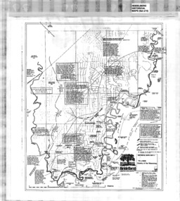
Map, Municipality of Heidelberg Plan No. 480, 17/10/1948
... Plenty Lower Plenty melbourne Map Municipality of Heidelberg Plan ...Map shows streets, buildings, river and major drainage easements in area covered by West boundary Sellars Street, North boundary Yando Street & South boundary Grimshaw Street. Adjoins Map No. 481 to East. Black & white map, features marked in green, gradients in red. Scale: 160 feet to 1 inchgreensborough -
 Greensborough Historical Society
Map, Municipality of Heidelberg Plan No. 481, 23/9/1949
... Plenty Lower Plenty melbourne Map Municipality of Heidelberg Plan ...Central area of Greensborough, South boundary Grimshaw Street, showing river and buildings in green and gradients in red. Adjoins Map No. 480 to West.Black & white map with features in red and green. Scale: 160 feet to 1 inch.greensborough, grimshaw street greensborough -
 Greensborough Historical Society
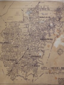
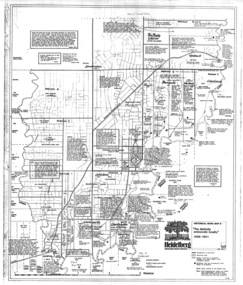
Map, City of Heidelberg: Municipal and Ward boundaries, 1967c
... Plenty Lower Plenty melbourne Map City of Heidelberg: Municipal ...This map of the City of Heidelberg was issued subsequent to the separation of Heidelberg's North Ward to become the Shire of Diamond ValleyBlack on waxed paper. Scale: 20 chs to 1 inchG M Hutchins. 50c.city of heidelberg, heidelberg -
 Greensborough Historical Society
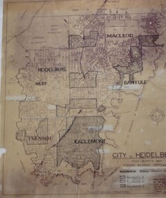
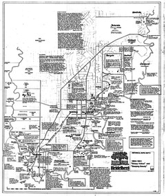
Map, City of Heidelberg: Residential Policy, 1976c
... Plenty Lower Plenty melbourne Map City of Heidelberg: Residential ...Shows residential zones 3, 4 & 5 established by Residential Policy adopted 13/12/1976Black print on waxed paper. Scale: 20 chs to 1 inchG M Hutchins. $1city of heidelberg, heidelberg -
 Greensborough Historical Society
Folder, Ian Bennetts, Is there a pattern to the distribution of burglaries and thefts reported to the Greensborough police station, and what factors may influence this? by Ian Bennetts, 1990_
Year 12 Geography individual research project, Montmorency Secondary College, 1990. Investigates whether there a pattern to the distribution of burglaries and thefts reported to the Greensborough police station, and what factors may influence this? by Ian Bennetts72 p. spiral bound loose leaf folder. Typescript, coloured maps and diagramsVictorian Police logo on title page.thefts, greensborough, police - greensborough -
 Greensborough Historical Society
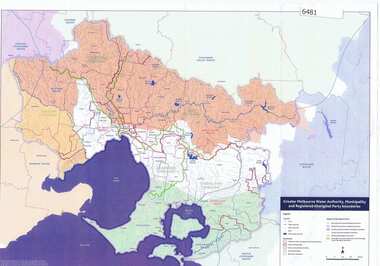
Maps, Greater Melbourne Water Authority, Municipality and Registered Aboriginal party Boundaries, 18/07/2018
... Plenty Lower Plenty melbourne Maps Greater Melbourne Water ...Shows Melbourne Water and Municipal area boundaries, with boundaries of registered aboriginal parties, in central Victoria.Printed in colour one sideMap reference 20180746aborigines victoria, water supply, melbourne water -
 Greensborough Historical Society
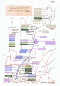
Maps, Yan Yean Water Supply System Conservation Management Plan: Construction dates Map 1, 2007_
... Plenty Lower Plenty melbourne Maps Yan Yean Water Supply System ...Plan of Yan Yean Water Supply System, showing natural and constructed features from 1850s to 1930s from Silver Creek Weirs to Eastern Freeway.Printed in colour one side. 3 copieswater supply, yan yean reservoir, plenty river -
 Greensborough Historical Society
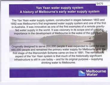
Booklet, Yan Yean water supply system: a history of Melbourne's early water supply system, 2010c
History of the Yan Yean water supply system - Melbourne's earliest. This is an early version of the history.Link: 6479:6482 24 p., colour illus., mapsyan yean reservoir, melbourne water -
 Greensborough Historical Society
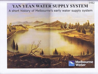
Booklet, Yan Yean water supply system: a short history of Melbourne's early water supply system, 2011c
Early history of the Yan Yean water supply systemLink: 6479:6482 40 p., colour illus. and mapsyan yean reservoir, toorourrong reservoir, melbourne water -
 Greensborough Historical Society
Map, Heidelberg: Historic River Landscape Assessment, Historical Maps. Map A To 1838. Country of the Wawarang, 1985c
... Plenty Lower Plenty melbourne Map Heidelberg: Historic River ...Geographical area of around 35 sq. kilometres marked with physical features such as major roads, rivers, vegetation and properties, with contemporary notes on landowners, descriptions and comments on the land and its development. Bounded by Shire of Diamond Valley to the North, Darebin Creek to the West and Plenty River to the East.Black an white sketch map on white paperheidelberg, heidelberg - maps -
 Greensborough Historical Society
Map, Heidelberg: Historic River Landscape Assessment. Historical Maps. Map B 1838-1851, "The Distinctly aristocratic locality", 1985c
... Plenty Lower Plenty melbourne Map Heidelberg: Historic River ...Geographical area of around 35 sq. kilometres marked with physical features such as major roads, rivers, vegetation and properties, with contemporary notes on landowners, descriptions and comments on the land and its development. Bounded by Shire of Diamond Valley to the North, Darebin Creek to the West and Plenty River to the EastBlack and white sketch map on white paperheidelberg, heidelberg - maps -
 Greensborough Historical Society
Map, Heidelberg. Historic River Landscape Assessment. Historical maps: Map C 1851-1863. "The Garden of the colony", 1985c
... Plenty Lower Plenty melbourne Map Heidelberg. Historic River ...Geographical area of around 35 sq. kilometres marked with physical features such as major roads, vegetation and properties, with locations and notes of the increasing number of farms, gardens orchards and vineyards which had become established in addition to pastoral runs. Bounded by Shire of Diamond Valley to the North, Darebin Creek to the West and Plenty River to the East.Black and white sketch map on white paperheidelberg, heidelberg - maps -
 Greensborough Historical Society
Map, Heidelberg: Historic River Landscape Assessment. Historical maps. Map D 1864 -1901 "Sleepy Hollow" and "Sleeping beauty", 1985c
... Plenty Lower Plenty melbourne Map Heidelberg: Historic River ...Geographical area of c. 35 sq. kilometres marked with physical features such as major roads, rivers, vegetation and properties, with locations and notes on the increasing number of farms, orchards and vineyards that had been developed in addition to pastoral runs. Bounded by Shire of Diamond Valley to the North, Darebin Creek to the West, and Plenty River to the East.Black and white sketch on white paper. Second copy 600 x 430 cm printed in black on semi-opaque paperheidelberg, heidelberg - maps -
 Greensborough Historical Society
Map, Heidelberg: Historic River Landscape Assessment. Historical maps. Map E 1901-1934 "A Time of projects and improvements", 1985c
... Plenty Lower Plenty melbourne Map Heidelberg: Historic River ...Geographical area of around 35 sq. kilometres marked with physical features such as major roads, railways (new extension to Eltham), rivers and properties, also housing sub-divisions and community facilities such as hospitals, parks and sporting reserves and indications of new small scale industries such as dairying. Bounded by Shire of Diamond Valley to the North, Darebin Creek to the West and Plenty River to the East. Black and white sketch map on white paperheidelberg, heidelberg - maps -
 Greensborough Historical Society
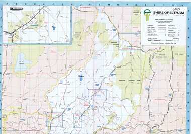
Map, Shire of Eltham, 1990c
... Plenty Lower Plenty melbourne Map Shire of Eltham Colour map ...1:20000 map of Shire of Eltham, with enlargements of a number of areas.Colour map, printed both sides.shire of eltham, eltham -
 Greensborough Historical Society
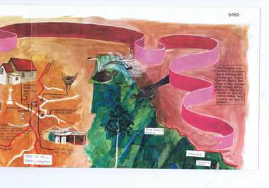
Map, Cultural heritage Map Shire of Eltham, designed and painted by Megan Evans, 1993_
... Plenty Lower Plenty melbourne Map Cultural heritage Map Shire ...An annotated map of the Shire of Eltham showing places of interestColoured map, folded four times, annotated with historical notes and descriptions of physical and natural featuresshire of eltham -
 Greensborough Historical Society
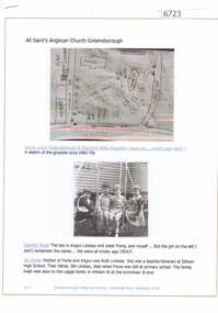
Article and Photograph, All Saints Anglican Church Greensborough, 2018_
Information and photographs of All Saints' Anglican Church Greensborough from the 1940s and 1950s. Includes a hand drawn map of the original site on the corner of Main Street and Grimshaw Street.This photograph and text was copied from a Facebook site. Members are people who lived in the Greensborough area and share their reminiscences of the area with others. The site is administered by a GHS member but is not officially affiliated with the Society. Any information is the opinion of the contributor. Article and photograph sourced from social media.all saints anglican church greensborough -
 Greensborough Historical Society
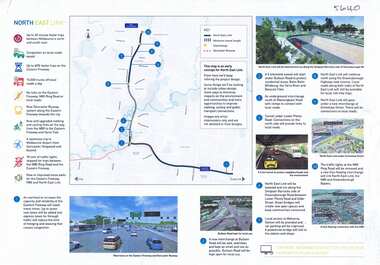
Leaflet, North East Link community update 04 April 2018; and, Map of proposed North East Link, 2018_04
Updates on North East Link project.1 sheet, printed in colour both sides (update) and single sided colour map and notes.north east link -
 Greensborough Historical Society
Booklet, TAA Air Atlas, 1972_
Souvenir publication, detailing airline routes, services and aircraft. TAA air atlas: your flight souvenir, compliments of Trans-Australia Airlines.16 p., printed in colour, maps, photographs and text.airlines, trans-australia airlines -
 Greensborough Historical Society
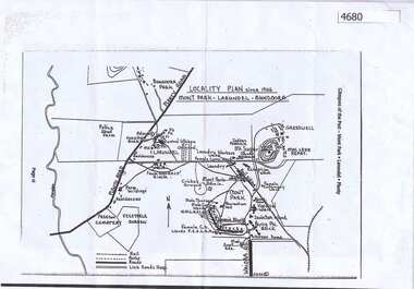
Map, Mont Park buildings still existing, 1946_
... Plenty Lower Plenty melbourne Map Mont Park buildings still ...Locality Plan indicates buildings still existing within the Mont Park - Larundel mental health complex; Table lists 16 buildings by year built, initial purpose, subsequent uses and current address2 pages,one map, one table larundel, mont park -
 Greensborough Historical Society
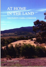
Book, Geoff Lacey, At home in the land: the Plenty-Yarra corridor, 2021
111 p., paperback, col. photographs, mapsnon-fictionindigenous plants, indigenous fauna, plenty river, yarra river -
 Greensborough Historical Society
Map - Map (Copy), C. Hodgkinson, District Surveyor et al, Parish of Yan Yean 1856: Village site during construction of the Yan Yean Reservoir, 1978
... Plenty Lower Plenty melbourne Map (Copy) Map Parish of Yan Yean ...Copy of map part Sec. 13, Parish of Yan Yean 1856, Map 3, Village site... Scale: 8 chains to 1 inch. Drawn by C. Hodgkinson, District Surveyor, redrawn by A. R. Blair 1978. 1 p. photocopy of map. yan yean reservoir, yan yean -
 Greensborough Historical Society
Map, Dianne Edwards, Part of Parish of Yan Yean 1878, 1978
... Plenty Lower Plenty melbourne Map Map Part of Parish of Yan Yean ...Map includes Crown Portions V - XVII, showing Yan Yean Reservoir, Melbourne-Whittlesea Railway route, names of landowners, roads and various other features west of Greensborough Road. Redrawn by A. R. Blair in 1978.1 p. black and white photocopy of mapyan yean reservoir, yan yean -
 Greensborough Historical Society
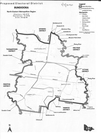
Map - Map (Copy), Electoral Boundaries Commission, Proposed electoral district: Bundoora, 01/07/2021
... Plenty Lower Plenty melbourne Map (Copy) Map Proposed electoral ...Proposed revised electoral boundaries for the electoral district of Bundoora (North-Eastern Metropolitan Region) as at 01/07/20211p. black and white copy of mapelectoral boundaries, bundoora - maps, victoria - parliament -
 Greensborough Historical Society
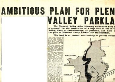
Newspaper Clipping - Digital Image, Ambitious plan for Plenty Valley Parklands 1965, 05/11/1965
In 1965, the Diamond Valley Shire planning association recommended to Council that a large area of land north of Greensborough be acquired for Parkland. The idea of a Civic Centre was included with a map of the area from Grimshaw Street in the south to the MMBW pipeline reserve in the north. Includes a suggested new site for the local school, near Yando Street. This area is now part of the Plenty River Trail.An example of developments in the Greensborough area during the period of Shire of Diamond ValleyNews clipping, black and white text and map. Scanned in 3 parts.shire of diamond valley, civic drive greensborough, yando street greensborough, partingtons flat, plenty river trail -
 Greensborough Historical Society
Flyer - Leaflet, Watsonia Heights Primary School Fete 2020 WH4935, 14/03/2020
The Watsonia Primary School Fete, held on Saturday 14th March, was one of the last activities held before the Covid lockdown in 2020Single page, printed in colour on front and black and white map of school on back.watsonia primary school, school fetes, henry street greensborough -
![Work on paper - Newsletter, North East Link & Hurstbridge Railway Line: Community Update [Sept. 2020], 2020_09](/media/collectors/4f729f5697f83e03086015b8/items/6014eb092bef110c704f0fb5/item-media/6014eb9a2bef110c704f1691/item-fit-380x285.jpg) Greensborough Historical Society
Greensborough Historical SocietyWork on paper - Newsletter, North East Link & Hurstbridge Railway Line: Community Update [Sept. 2020], 2020_09
Banyule City Council comments on the North East Link & Hurstbridge Railway Line projects. This newsletter is to keep the community informed of developments and opportunities for consultation. Includes a sketch map of Watsonia from Grimshaw Street to Lower Plenty Road.4 page leaflet, colour text and images.north east link, hurstbridge rail line, banyule city council, watsonia -
![Work on paper - Newsletter, North East Link getting it right [June 2020], 2020_06](/media/collectors/4f729f5697f83e03086015b8/items/6014ef952bef110c704f3c4c/item-media/6014f0882bef110c704f42bf/item-fit-380x285.jpg) Greensborough Historical Society
Greensborough Historical SocietyWork on paper - Newsletter, North East Link getting it right [June 2020], 2020_06
Banyule City Council comments on the North East Link project. This newsletter is to keep the community informed of developments. Includes a sketch map from the M80 Ring Road to Lower Plenty Road.2 page leaflet, colour text and images.north east link, banyule city council, watsonia -
 Greensborough Historical Society
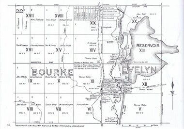
Article, Norm Colvin, Events leading up to the Plenty Ladies' Petition 1842, 2020_
This article, written and researched by Norm Colvin, GHS Secretary, identifies the people involved in the events leading to the petition to the Governor of Victoria, C. J. La Trobe, from 'Ladies resident on Plenty River' requesting protection from bushrangers, 5 May 1842. It identifies the bushrangers, the owners of the stations robbed, the group of men who rode out to assist and the identity of the "ladies" who signed the petition.This article identifies the people involved in the incidents, a list of locals in the 1840s.12 pages typescript, map.plenty river, bushrangers, petitions -
 Greensborough Historical Society
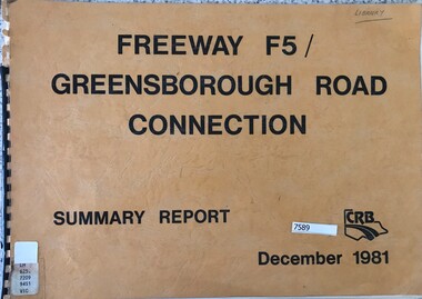
Book - Report, Country Roads Board, Freeway F5 / Greensborough Road connection. December 1981, Summary Report, 1981_
Summary report of the Country Roads Board's 1981 proposals for the F5 Freeway (now Metropolitan Ring Road) between Dalton Road and Diamond Creek Road and the duplication of Greensborough Road (Greensborough By-pass).Historic proposal for roads in the Greensborough area51 pages, text, colour maps. Plastic binding.country roads board, greensborough bypass, metropolitan ring road, greensborough road