Showing 12326 items matching "pond-island"
-
 Phillip Island and District Historical Society Inc.
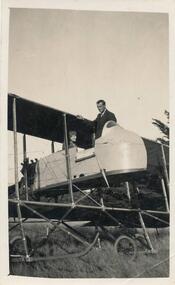
Photograph, Bi-plane on Phillip Island
From Jessie Smith's collection of Island Events & Landscapes. 1st plane to land at Phillip Island.Pilot sitting in Bi-plane. Man in suit welcoming.local history, photographs, transport, aviation, aircraft, phillip island, black & white photograph, jessie smith collection, stan mcfee -
 Phillip Island and District Historical Society Inc.
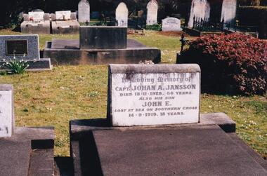
Photograph Album, Kodak, Phillip Island Cemetery, c 1990
The Album was compiled by Nancy McHaffie late 1990's, with the assistance of Edith Jeffery's, with her book "Garden of Memories" and extensive knowledge of Phillip Island. The Cemetery lies back from the road and is surrounded by Manna Gums, rare Peppermint Gums, Blackwoods and other native trees. In all 25 acres of land were set aside as Crown Land in the land settlement of 1868. There are 6.2 acres of wetlands near the cemetery entrance.466-44: Captain Johan Jansson. Capatain Jansson was born in 1862 and came to Australia on the ship "Nosstaljee" in 1886. In 1887 he came to the Island and started work with Captain Lock. He bought land at Rhyll in 1891 and built a house two years later, now known as Jansson's Cottage. Johan married Evelyn Power.. a daughter of Captain Powell. He purchased the ketch "Swan" and later :Stephen" in 1914. They took chicory, seaweed, hay and other farm produce to Melbourne, returning with general cargo. Captain Jansson died in 1928 aged 66 years. 466-45: Evelyn Jansson. Evelyn was the daughter of Captain Powell. She married Johan Jansson on her 18th birthday. She died 1971 aged 95 years. Their daughter Mavis is buried with Evelyn - died 1971 aged 72 years.phillip island cemetery, johan jansson, evelyn jansson, mavis jansson, nancy mchaffie, edith jeffery -
 Phillip Island and District Historical Society Inc.
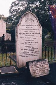
Photograph Album, Kodak, Phillip Island Cemetery, c 1889
The Album was compiled by Nancy McHaffie late 1990's, with the assistance of Edith Jeffery's, with her book "Garden of Memories" and extensive knowledge of Phillip Island. The Cemetery lies back from the road and is surrounded by Manna Gums, rare Peppermint Gums, Blackwoods and other native trees. In all 25 acres of land were set aside as Crown Land in the land settlement of 1868. There are 6.2 acres of wetlands near the cemetery entrance.Captain McLeod: Captain McLeod and family kept the Post Office at Newhaven. He also built a boat called old "Trusty" and launched it almost opposite Churchill Island. Unfortunately, at a later date, the "Trusty" was the cause of a tragedy. The bottom of the boat had become so encrusted with marine growth that the owner decided to beach her between the jetties at Griffiths point, now San Remo. Before the job was completed the soring gave way and allowed the boat to tip over on her side, causing Captain McLeod to be crushed to death. Died March 3rd 1880 aged 64 years. Also buried in this grave is his wife Susan - died May 24th 1882 aged 62 years. Their son Andrew McLeod died February 21st 1916 aged 60 - loved husband of Elizabeth E McLeod. Alexander was Captain of the "Genista" for 12 years.phillip island cemetery, captain alexander mcleod, susan mcleod, andrew mcleod, nancy mchaffie, edith jeffery -
 Phillip Island and District Historical Society Inc.
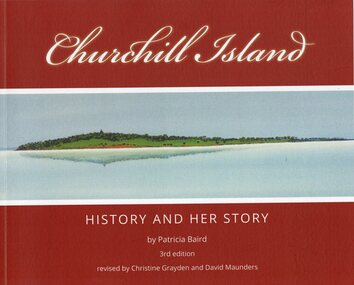
Book, Churchill Island : history and her story, Original 2001 - 3rd Edition 2021
Churchill Island - Lieut. James Grant visited 21 March - 9 April 1801 and planted seeds. Story of the development of the Island and people who lived on it.Churchill Island History and Her Story by Patricia Baird, 3rd Edition. Revised by Christine Grayden and David MaundersAs Abovechurchill island, patricia baird, christine grayden, david maunders, george bass, james grant -
 Lakes Entrance Historical Society
Photograph - Lipscombe brothers, Raymond Island opposite Paynesville Victoria, 1914 c
Black and white photograph of the four Lipscombe brothers Vic, Syd, Leonard and Jack banding pipe for a boat motor being built on Raymond Island opposite Paynesville Victoria. Also a black and white photograph of the Lipscombe brothers and crew in their fishing boat. transport, boats and boating, waterways -
 Phillip Island and District Historical Society Inc.
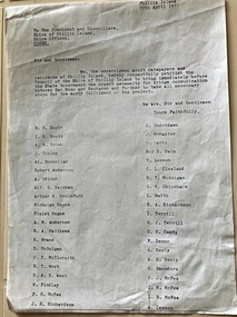
Document, Petition for bridge between Phillip Island and San Remo 1937
On 29 November 1940, a suspension bridge opened between San Remo on the mainland and with Newhaven on Phillip Island. The 540 metre bridge had two lanes but no footpaths, instead having six pedestrian refuges. The main span was 168 metres long. The cables had previously been used on a bridge on Sydney's North Shore. Because of weight restrictions, tourist coaches had to offload their passengers. [Wikipedia]HistoricalFoolscap size photocopy of a petition to Shire of Phillip Island for a bridge to Phillip Island in 1937. Signed by 42 local residents and ratepayers.first phillip island bridge to san remo, phillip island suspension bridge, petition, odlum, ockleford, regos, mcguigan, west, mcfee, richardson, underdown, mcmaster, cleeland, neely, leeson, saunders, scott, brown, hislop, donnellan, rackham, findlay, anderson -
 Phillip Island and District Historical Society Inc.
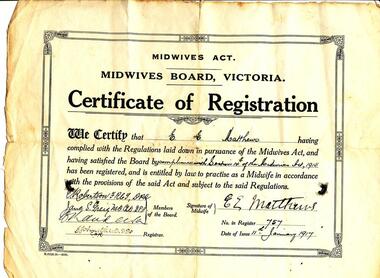
Certificate, Midwives Board Victoria et al, 1917 and 1947
E E Matthews was our donor, Alice Robinson's grandmother. Alice was the debutante - nee Clark.345-01: A Certificate of Registration for E. E. Matthews from the Midwives Board, Victoria on the 11th January, 1917. 345-02: A small cardboard programme with 4 pages inside for dance programme of the Debutante Ball held at the Cowes Shire Hall on the 26th September 1947. Small white pencil attached.midwives certificate, e e matthews, debutante ball programme, alice clark, alice robinson -
 Phillip Island and District Historical Society Inc.
Souvenir, 21/11/1969
Part of an album compiled and donated by Mrs Helen Jansson. Official Souvenir Ticket to opening of second Phillip Island Bridge to San Remo 1969.Deep Blue Souvenir Ticket featuring old and new Bridges. Photograph inserts at left and right bottom 'Opening of new Phillip Island Bridge 21/11/1969'Shire of Phillip Island - opening of Phillip Island Bridgelocal history, documents, tickets, civil engineering, bridges, phillip island bridge 1969, opening ceremony, cardboard ticket, mrs helen jansson, official opening of second phillip island bridge -
 Phillip Island Conservation Society Inc.
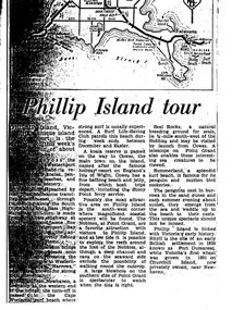
Work on paper - Photocopy of newspaper cutting, "Phillip Island tour", circa 1950s?
The article relates the journalist's visit to Phillip Island, starting from Melbourne and describing features along the way, then at San Remo on mainland side of Phillip Island bridge, then Newhaven on the other. Other places visited include the main town of Cowes, the jetty and beach there, and the Nobbies (Point Grant), with views of the Seal Rocks offshore through telescope at the Nobbies. The writer also visited Summerland beach, described as a surf beach, with penguin and mutton bird rookeries. While not specifically referring to the Penguin Parade, the writer says the spectacle of seeing the penguins coming ashore is not to be missed. The brief military colony at Rhyll and the first Victorian 'garden' planted at Churchill Island in 1801 are also mentionedArticle is significant because it is an early (1950s?) tourist guide to Phillip Island's most popular tourist destinations. 3 column text under map of Phillip Island. Black print on white paper. phillip island, newhaven, , westernport, surf beaches phillip island, summerland beach, penguins, mutton birds, the nobbies, point grant, seal rocks, cowes, nobbies blowhole, rhyll, churchill island, nobbies telescope -
 Lakes Entrance Historical Society
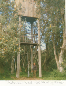
Photograph, Vera Bennett, Rotamah Island, Gippsland Lakes Victoria, 1/04/1989 12:00:00 AM
Colour photograph of the bird watching tower on Rotamah Island showing a timber hut and viewing platform supported on four timber poles accessed by steel ladders. Tower situated amongst coastal banksias Gippsland Lakes Victoria. Also another colour photograph of bird watching towerpeople, wildlife, topography, waterways -
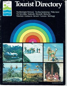 Phillip Island and District Historical Society Inc.
Booklet, Tourist Directory 1981 and Guide to Phillip Island & surrounds 1995
HistoricalLarge black booklet with brightly coloured cover with tourist photos. Inside is black type with descriptions, maps, advertisements and photos. Guide is smaller with white and red writing and maps. Inside it has red writing on history, climate and information on Phillip Island and small advertisements of attractions.Tourist Directory, Published by Westernport Healesville Regional Tourist Authority Victoria. Printed by Standard Newspapers, Cheltenham. Guide to Phillip Island & surrounds.Phillip Island Information Centre RMB 1305 Newhaven.tourism, tourist brochure, accomodation, restaurants, map of phillip island -
 Phillip Island and District Historical Society Inc.
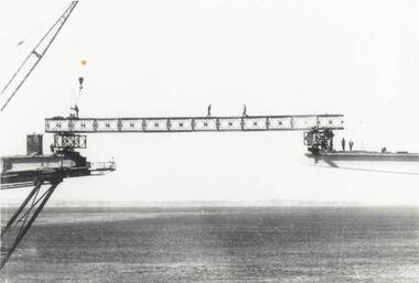
Photograph, Phillip Island Bridge, 1968/9
Construction of 2nd Phillip Island Bridge. 1969. From the Jack Jenner Collection.Scaffolding for concrete works for new Bridge. Top view of empty forming close-up.local history, photographs, civil engineering, bridges, phillip island bridges, black & white photograph, jack jenner collection, public construction -
 Phillip Island and District Historical Society Inc.
Photograph, Phillip Island Bridge, 1968/9
1969 Phillip Island Bridge under construction. From the Jack Jenner Collection.Joining Girder between two sides of new Bridge. Part of crane shown. Men on the girder and each side.local history, photographs, civil engineering, bridges, phillip island bridge under construction, black & white photograph, jack jenner collection, phillip island bridges, public construction -
 Phillip Island and District Historical Society Inc.
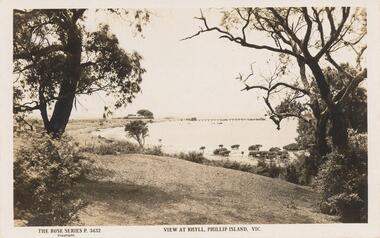
Sepia Photograph, 1920
This album was presented to the Earl of Stradbroke by Fathers of Soldiers on Phillip Island. The photo is of Rhyll shore line with pier in back ground.Sepia photograph of the shore at Rhyll, Phillip Island with pier in background.Rose Series P 3432 View at Rhyll, Phillip Island, Vicphillip island, rhyll shoreline, rhyll pier -
 Phillip Island and District Historical Society Inc.
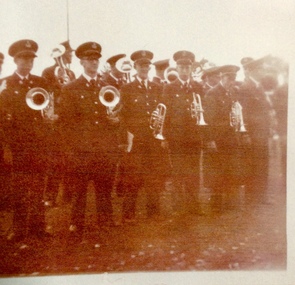
Photograph, Phillip Island Brass Band
Copy of a sepia photogragh of members of a brass band with instruments.L-R Murray De La Haye ( Harry’s son ), Unknown, Graham Gliddon, Melvyn De La Haye ( Harry’s son), Bryant West, Peter Forrest, Phillip Island BrassBandphillip island brass band, de la haye family, musical instruments, photographs, graham gliddon, bryant west, peter forrest -
 Phillip Island and District Historical Society Inc.
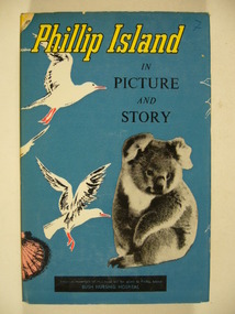
Book, Phillip Island in picture and story, 1977 reprint
The author Joshua Wickett Gliddon farmed on Phillip Island in the 1940s.The first published history of Phillip Island in 1958.1977 reprint, 400 p., illus.Issued by the Committee of Trust, "Warley", Cowes Bush Nursing Hospital, Phillip Island.phillip island, joshua wickett gliddon, phillip island - history, phillip island in picture and story -
 Phillip Island and District Historical Society Inc.
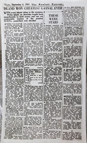
Article, "Island won greatest G-Final ever" 1951
The Powlett Express was based in Wonthaggi, precursor to The Sentinel Times. WDFL was the Wonthaggi and District Football League. Shops were Wonthaggi Shops team. This photo was prepared for inclusion in "Phillip Island in Picture and Story" by Gliddon but never used.HistoricalBlack and white photo of newspaper article The Powlett Express Thursday September 6, 1951. " Island won the greatest G-Final Island" "In Saturday's Grand-Final", "These were stars"phillip island football club 1951 premiers, joshua gliddon, the powlett express 1951, redda claringbould, wagner, bill jones -
 Phillip Island and District Historical Society Inc.
Photograph, Phillip Island Bridge, 1968/9
1969 2nd Phillip Island Bridge under construction. Suspension Bridge demolished early 1970 From the Jack Jenner CollectionConcrete stanchions and scaffolding of new Bridge part built.(opened 1969). Taken from other half looking towards San Remo.local history, photographs, civil engineering, bridges, phillip island bridges, black & white photograph, jack jenner collection, public construction -
 Phillip Island and District Historical Society Inc.
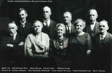
Photograph, Family Photographs and Back to Phillip Island
1041-01 Family of Elizabeth Rebecca Bryant & Solomon West - family identified c1924 - ?? 1926 1041-02 Back to Phillip Island c 1924. People identified in 1989 by Mrs Beth Freeman, daughter of William Otway MorrisonHistorical1041-01 Photograph: Family of Elizabeth Rebecca Bryant & Solomon West 1041-02 Photograph: Back to Phillip Island c 1924 with names1041-01: Family of Elizabeth Rebecca Bryant & Solomon West Back L-R Alfred Ernest West, Albert Bryant, Edwin Calver, William Joseph Front L-R Charles Solomon, Alice Elizabeth McDonald, Fanny Maria Morrison, Emily Elizabeth Lock, Harry Thomas 1041-02: Back to Phillip Island c.1924 Identification 1989, Mrs Beth Freeman daughter of William Otway Morrison Front L-R 1. Dan Morrison 2. Ted West 3. Norman McDonald 4. William West s/o Solomon 5. ? 6. William Otway Morrison Second Row L-R 1.? 2. Miriam West Henderson d/o John 3. ? 4. Emily West Lock d/o Solomon 5. ? 6. Fanny West Morrison w/o No. 6 above, d/o Solomon 7. Child to 10 (man with pipe) not identified Back Row L-R 1 to 5 not identified 6. Albert West, s/o Solomon 7. Marion Somerville West 8. Janet Morrison w/o Wm West (obscured) 9. Harry Brown 10. Nell West Brown d/o William West 11-13 unidentified 14. Alice West McDonald d/o Solomon 15. Jenny?west, back to phillip island c1924, morrison family, bryant, solomon -
 Phillip Island and District Historical Society Inc.
Photographs, 1926
Part of a collection of photographs cut from old photo album with multiple photos per page. Margaret Webster donated the photographs. Margaret's parents were Sir Charles & Lady McGrath who lived near the RSL on Ventnor Road, Phillip Island.286-01 - Sepia photograph of the beach at Cape Woolamai, Phillip Island. 286-02 - Sepia photograph of The Sentinel, Cape Woolamai, Phillip Island. 286-03 - Sepia photograph of The Terrace, Cape Woolamai, Phillip Island. 286-04 - Sepia photograph of Pyramid Rock, Phillip Island. 286-05 - Sepia photograph of the cliffs at Cape Woolamai, Phillip Island.286-01 - "Beach Cape Woolamai Phillip Island" 286-02 - "The Sentinel Cape Woolamai Phillip Island" 286-03 - "The Terrace Cape Woolamai" 286-04 - "Pyramid Rock P.I." 286-05 - "Cliffs - Cape Woolamai"coastline cape woolamai, pyramid rock, the sentinel cape woolamai, the terrace cape woolamai, margaret webster -
Phillip Island and District Historical Society Inc.
Photograph, 1929-1938
Phillip Island Punt - 1929/1938. Part of an album compiled and donated by Mrs. Helen JanssonBlack & White Print (probably from a publication) of the 2-car Phillip Island PuntDescriptive caption adjoining photo print 1929 "Phillip Island Punt"local history, photography, photographs, slides, film, civil engineering, bridges, phillip island bridge, black & white photograph, mrs helen jansson, early connection to mainland, bridges -
 Churchill Island Heritage Precinct
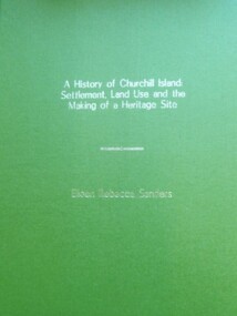
Book - Thesis, Dr E. Rebecca Saunders, A History of Churchill Island: Settlement, Land Use and the Making of a Heritage Site, 2015
An exploration of the intersections between the practices of community engagement, academia and history, the thesis responds to the challenges thrown up by the History Wars and the Churchill Island Project by making a history of settlement that is both academically critical and publicly accepted.A4 format bound text, with green front and back covers and gold writing on front page.non-fictionAn exploration of the intersections between the practices of community engagement, academia and history, the thesis responds to the challenges thrown up by the History Wars and the Churchill Island Project by making a history of settlement that is both academically critical and publicly accepted.saunders, churchill island, settlement, land use, heritage site, thesis 2015 -
Phillip Island and District Historical Society Inc.
Book, CUTTER, June M, Churchill Island : a special place : a story of those who chose Churchill Island as their haven, 1994
Stamped 'Phillip Island & District Historical Society'. Proceeds of this book are donated to the Friends of Churchill Island Society.pioneers, victoria, churchill island, history, fiction -
University of Melbourne, Burnley Campus Archives
Photograph - Sepia print, 15, 1929
Lily PondLily Pond Nov 1929."lily ponds, garden views -
 Phillip Island and District Historical Society Inc.
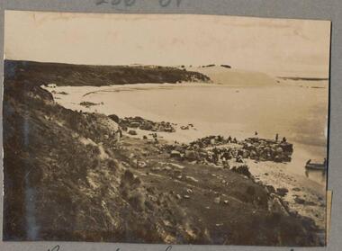
Sepia Photograph, 1920
This ablum was presented to the Earl of Stradbroke by the Fathers of Soldiers and Returned Soldiers 16/2/1923. The photo is of the Back Beach near The Nobbies, Phillip Island.Postcard showing the Back Beach near The Nobbies, Phillip Island, VictoriaRose Series P667 Back Beach, near The Nobbies, Phillip Island, Victoriaphillip island, back beach, earl of stradbroke, the nobbies -
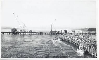 Phillip Island and District Historical Society Inc.
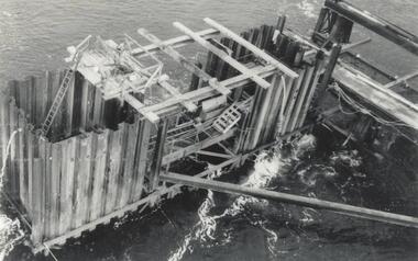
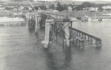
Photographs, Country Roads Board, Construction of 2nd Phillip Island Bridge 1966 - 1969, 1966 - 1969
Collection of Black & White photographs of the construction of the second Phillip Island Bridge by the Country Roads Board. Contractor John Holland & Co Pty. Ltd.Black & White photographs of the Construction of the Phillip Island 2nd Bridge in 1969 351-01: View from centre of suspension bridge. 351-02: Concreting Pier 8 351-03: Concreting Pier 8 351-04,05 & 06: Metal beams. 351-07: Driving sheet Piling. 351-08:Reinforcement in caisson (watertight structure)351-01: Country Roads Board Victoria, Aust. Negative No. 67-37 - Phillip Island Bridge Project. Shire of Bass 352-02: As above - Negative No. 67-38B 352-03: As above - Negative No. 57-38D. 352-04: Negative No. 67-223A. 352-05: Negative No. 67-223B 352-06: Negative No. 67-223D 352-07: As 352-01-03 plus Negative No. 67-312 352-08: As above - Negative No. 67-272.phillip island bridge (1969), country roads board, sasha stark -
 Phillip Island and District Historical Society Inc.
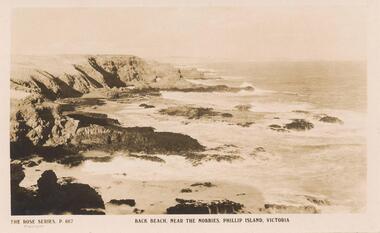
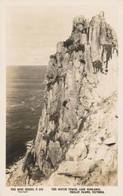
Sepia Photograph, 1920's
This album was presented to the Earl of Stradbroke by Fathers of Soldiers and Returned Soldiers 16/02/1923. Photo showing cliffs called The Watch Tower, Cape Woolamai, Phillip Island.Cliff known as "The Watch Tower", Cape Woolamai, Phillip Island, VictoriaRose Series P679. The Watch Tower, Cape Woolamai, Phillip Island, Victoriaphillip island, cape woolamai, earl of stradbroke, the watch tower cliffs -
 Lakes Entrance Historical Society
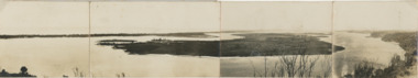
Postcard, Reeves Channel, Rigby Island, the entrance, Bullock Island , Lakes Entrance Victoria, 1920 c
Views of Gippsland Lakes from Jemmy's Point Lakes EntranceBlack and white panoramic folding postcard of the Gippsland Lakes including Reeves Channel, Rigby Island, the entrance, Bullock Island and Lakes Entrance township taken from Jemmys Point Lakes Entrance Victoria. Also panoramic postcard view from southern part of Rigby Island to Lakes Entrance township. And a third postcard "KALIMNA COVE LAKES ENTRANCE"waterways, gippsland lakes -
 Eltham District Historical Society Inc
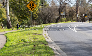
Photograph, Peter Pidgeon, Site of former pond, Main Road, Eltham, 2 Aug. 2022
The view is taken from Main Road opposite Dalton Street looking northwest across Wingrove Park Trail and White Cloud cottage which belonged to the Jarrold family Comparison photo: 00779 - Pond near Eltham Park, c.1910 Shows the pond near Eltham Park (later Eltham Lower Park) circa 1910. The view is taken from Maria Street (Main Road) opposite Dalton Street looking northwest across the Dalton Street road extension reserve (now Wingrove Park Trail) and Jarrold farm. A haystack is visible. Also visible is a kerosene streetlight and Jarrold family cottage The pond was drained by Council in 1932 due to claims of mosquitoes though locals such as Thekla Jarrold and John Clark disputed this and protested to Council about the draining. It was in this news article that Thekla stated she had lived there 39 years and John Clark 22 years without cause for concern. Part of a presentation by Peter Pidgeon to the Society, 13 August 2022 showcasing a series of photographs taken by John Henry Clark over the period 1895 to 1930. John Henry Clark was the youngest of three boys born to William Henry Clark (1823-1877) and Maria White (1843-1914). He and his brothers, William Charles Clark (1872-1945), Clement Kent Clark (1874-1912) operated a photography business (Clark Bros.) from 25 Thomas Street, Windsor near Prahran during the period c.1894 to 1914. Following death of Clement in September 1912 and their mother in 1914, the Clark Bros business appears to have dissolved, the premises demolished, and a new house was under construction in 1915. John set up business independently in 1914 operating out of 29 Moor Street, Fitzroy where he is registered in the 1914 and 1915 Electoral Rolls. By 1916 John had relocated to Eltham where he continued his practice as a photographer and took many of the early images around the district of Little Eltham. Around 1930 John changed professions and opened a small cobbler's shop in 1931 near the pond opposite Dalton Street adjacent to the Jarrold family cottage. He never married and continued his profession as a bootmaker from this little shop, maintaining a close relationship with Mrs Jarrold for the rest of their lives. His bootmaker shop remains today beside the Whitecloud cottage and is one of only three remaining shops in the area from the early 20th century.Comparative photo taken 2022 with one taken from same location over 100 years earlier by noted local photographer J.H. ClarkBorn Digitaleltham, j.h. clark photo (2022), bootmaker's shop, dalton street, diamond creek trail, jarrold cottage, main road, white cloud cottage, wingrove park trail -
Phillip Island and District Historical Society Inc.
Photograph
Phillip Island suspension Bridge built 1938/1940 - demolished 1970. Part of an album compiled and donated by Mrs Helen Jansson.Print of Phillip Island Suspension Bridge. Aerial view showing Jetties at left with sweep of sandy beaches middle to top left.No. 1. Phillip Island Bridge, Victoria. Airapy Photolocal history, photography, photographs, slides, film, civil engineering, bridges, jetties, phillip island suspension bridge, black & white photograph, mrs. helen jansson, suspension bridges, phillip island