Showing 432 items matching "quarry road"
-
 Glenelg Shire Council Cultural Collection
Photograph - Photograph - Cape Grant Quarry, 14/11/1957
Port of Portland Authority ArchivesBack: Purple PHT stamp '14 NOV 1957' 'BLAST AT CAPE GRANT QUARRY'port of portland archives, cape grant quarry -
Glenelg Shire Council Cultural Collection
Photograph - Photograph - Cape Grant Quarry, 01/10/1954
Port of Portland Authority ArchivesBack: Purple PHT stampport of portland archives, cape grant quarry -
Glenelg Shire Council Cultural Collection
Photograph - Photograph - Cape Grant Quarry, n.d
Port of Portland Authority Archives -
Glenelg Shire Council Cultural Collection
Photograph - Photograph - Cape Grant Quarry, n.d
Port of Portland Authority Archivesport of portland archives, cape grant quarry -
Glenelg Shire Council Cultural Collection
Photograph - Photograph - Cape Grant Quarry, n.d
Port of Portland Authority Archivesport of portland archives, cape grant quarry -
Glenelg Shire Council Cultural Collection
Photograph - Photograph - Cape Grant Quarry, 24/01/1968
Port of Portland Authority ArchivesBack: 'JAN 24, 1968 ' - pencil top rightport of portland archives, cape grant quarry -
Glenelg Shire Council Cultural Collection
Photograph - Photograph - Cape Grant Quarry, 30/06/1955
Port of Portland Authority ArchivesBack: Purple PHT stampport of portland archives, cape grant quarry -
Glenelg Shire Council Cultural Collection
Photograph - Photograph - Cape Grant Quarry, 30/04/1953
Port of Portland Authority ArchivesFront: 'BLACKNOSE QUARRY FACE 30.4.53'' LOOKING NORTH' Back: Purple PHT stamp -
Glenelg Shire Council Cultural Collection
Photograph - Photograph - Cape Grant Quarry, 03/02/1954
... road to Cape Grant quarry... on the access road to Cape Grant quarry Photograph Photograph - Cape ...Port of Portland Authority ArchivesBack: Purple PHT stampport of portland archives, cape grant quarry -
Glenelg Shire Council Cultural Collection
Photograph - Photograph - Cape Grant Quarry, n.d
Port of Portland Authority Archivesport of portland archives, cape grant quarry -
Glenelg Shire Council Cultural Collection
Photograph - Photograph - Cape Grant Quarry, 09/01/1959
Port of Portland Authority ArchivesBack: Purple PHT stamp '9 JAN 1959' '9/1/59' -pencil, top leftport of portland archives, cape grant quarry -
Glenelg Shire Council Cultural Collection
Photograph - Photograph - Cape Grant Quarry, 30/11/1953
Port of Portland Authority ArchivesBack: Purple PHT stamp -
Glenelg Shire Council Cultural Collection
Photograph - Photograph - Cape Grant Quarry, 15/01/1954
Port of Portland Authority ArchivesBack: Purple PHT stampport of portland archives, cape grant quarry -
Glenelg Shire Council Cultural Collection
Photograph - Photograph - Cape Grant Quarry, 02/11/1954
Port of Portland Authority ArchivesBack: Purple PHT stamp -
Glenelg Shire Council Cultural Collection
Photograph - Photograph - Cape Grant Quarry, n.d
Port of Portland Authority ArchivesBack: 'Harman excavator loading heavy rock at Cape Grant Quarry' - Green biro, bottom leftport of portland archives, cape grant quarry -
Glenelg Shire Council Cultural Collection
Photograph - Photograph - Cape Grant Quarry, n.d
Port of Portland Authority Archives -
 City of Moorabbin Historical Society (Operating the Box Cottage Museum)
Document - Genealogy Chart Henry Dendy (Photocopy), 19 thC
In 1840 Henry Dendy, a farmer in Surrey, England acquired a "Special Survey" from the Commissioners for Land and Emigration which gave Dendy the right to choose land in Port Phillip for the "bargain basement" price of only £1 per acre for 5120 acres, (an area of 8 square miles). The Special Survey also included the right to "the shipment of a worker for every £20 spent on land, whose free passage was paid by the Crown, equalling a total of 100 workers ". Accordingly Dendy sold his English holdings and paid the required £5120 and arrived in Melbourne in February 1841. However by this time land in the new colony was selling for £5 - £40 per acre. Because Henry Dendy possessed the order from the Colonial Office in London he was able to successfully oppose Super-intendant LaTrobe's attempts to alter the price of the land. Dendy appointed Jonathan Were, (an entrepreneur, who had arrived in 1839), as his Manager and who later became a partner. Together, Dendy and Were decided on an area 5 miles south from Melbourne, bounded by North Road, East Boundary Road, South Road and to the west by Port Phillip Bay. Were and Dendy pitched their tents in the area now known as ' Park St, Brighton' and sank a well near the corner of 'St Andrew's St and Wells St'. By 1845 J.B Were and Company had bought almost half of Dendy's land and Were built himself "Moorabbin House" in Were St Brighton made from stone, quarried from local cliffs. It was still standing in 1924. Legend records Moorabbin is named after the Aboriginal word for ' Mother's Milk ' The soil is very fertile and well supplied with water especially in the area called 'East Brighton' - now known as Bentleigh and East Bentleigh - By 1850 the area had developed with numerous market gardens, dairy farms, fruit gardens and vineyards supplying food for the growing population of Melbourne.In 1840 Henry Dendy, a farmer in Surrey, England acquired a "Special Survey" from the Commissioners for Land and Emigration which gave Dendy the right to choose land in Port Phillip for the price of only £1 per acre for 5120 acres. This land was called Brighton in the Parish of Moorabbin, County of Bourke and emigrants developed the land establishing market gardens , dairy and poultry farms that provided the food for the growing population of Melbourne. A photocopy of the Genealogy Chart of the Dendy Family that Henry Dendy brought with him when he emigrated to Melbourne 1841Genealogy signs and descriptionsdendy henry, dendy's special survey brighton 1841, governor gipps, captain lonsdale, super-intendant latrobe, port phillip, melbourne, new south wales, squatters, emmigrants, county of bourke, parish of moorabbin, early settlers, pioneers, market gardeners, dairy farmers, fruit farms, moorabbin, bentleigh, brighton, cheltenham, were jonathan binn, -
City of Moorabbin Historical Society (Operating the Box Cottage Museum)
Document, Henry Dendy family Shield
In 1840 Henry Dendy, a farmer in Surrey, England acquired a "Special Survey" from the Commissioners for Land and Emigration which gave Dendy the right to choose land in Port Phillip for the "bargain basement" price of only £1 per acre for 5120 acres, (an area of 8 square miles). The Special Survey also included the right to "the shipment of a worker for every £20 spent on land, whose free passage was paid by the Crown, equalling a total of 100 workers ". Accordingly Dendy sold his English holdings and paid the required £5120 and arrived in Melbourne in February 1841. However by this time land in the new colony was selling for £5 - £40 per acre. Because Henry Dendy possessed the order from the Colonial Office in London he was able to successfully oppose Super-intendant LaTrobe's attempts to alter the price of the land. Dendy appointed Jonathan Were, (an entrepreneur, who had arrived in 1839), as his Manager and who later became a partner. Together, Dendy and Were decided on an area 5 miles south from Melbourne, bounded by North Road, East Boundary Road, South Road and to the west by Port Phillip Bay. Were and Dendy pitched their tents in the area now known as ' Park St, Brighton' and sank a well near the corner of 'St Andrew's St and Wells St'. By 1845 J.B Were and Company had bought almost half of Dendy's land and Were built himself "Moorabbin House" in Were St Brighton made from stone, quarried from local cliffs. It was still standing in 1924. Legend records Moorabbin is named after the Aboriginal word for ' Mother's Milk ' The soil is very fertile and well supplied with water especially in the area called 'East Brighton' - now known as Bentleigh and East Bentleigh - By 1850 the area had developed with numerous market gardens, dairy farms, fruit gardens and vineyards supplying food for the growing population of Melbourne. dendy henry, dendy's special survey brighton 1841, governor gipps, captain lonsdale, super-intendant latrobe, port phillip, melbourne, new south wales, squatters, emmigrants, county of bourke, parish of moorabbin, early settlers, pioneers, market gardeners, dairy farmers, fruit farms, moorabbin, bentleigh, brighton, cheltenham, were jonathan binn, -
 City of Moorabbin Historical Society (Operating the Box Cottage Museum)
Document - Pedigree of Henry Dendy, c1840 Original ; Copy 1985
This is a copy of the document brought by Henry Dendy to the Colony in 1841. In 1840 Henry Dendy, a farmer in Surrey, England acquired a "Special Survey" from the Commissioners for Land and Emigration which gave Dendy the right to choose land in Port Phillip for the "bargain basement" price of only £1 per acre for 5120 acres, (an area of 8 square miles). The Special Survey also included the right to "the shipment of a worker for every £20 spent on land, whose free passage was paid by the Crown, equalling a total of 100 workers ". Accordingly Dendy sold his English holdings and paid the required £5120 and arrived in Melbourne in February 1841. However by this time land in the new colony was selling for £5 - £40 per acre. Because Henry Dendy possessed the order from the Colonial Office in London he was able to successfully oppose Super-intendant LaTrobe's attempts to alter the price of the land. Dendy appointed Jonathan Were, (an entrepreneur, who had arrived in 1839), as his Manager and who later became a partner. Together, Dendy and Were decided on an area 5 miles south from Melbourne, bounded by North Road, East Boundary Road, South Road and to the west by Port Phillip Bay. Were and Dendy pitched their tents in the area now known as ' Park St, Brighton' and sank a well near the corner of 'St Andrew's St and Wells St'. By 1845 J.B Were and Company had bought almost half of Dendy's land and Were built himself "Moorabbin House" in Were St Brighton made from stone, quarried from local cliffs. It was still standing in 1924. Legend records Moorabbin is named after the Aboriginal word for ' Mother's Milk ' The soil is very fertile and well supplied with water especially in the area called 'East Brighton' - now known as Bentleigh and East Bentleigh - By 1850 the area had developed with numerous market gardens, dairy farms, fruit gardens and vineyards supplying food for the growing population of Melbourne. A copy of a paper chart of the Pedigree of Henry Dendy in a wooden frame with glassPedigree / of the branch of the family / DENDY moorabbin, brighton, henry dend special survey 1841 y, early settlers, pioneers, market gardeners -
Glenelg Shire Council Cultural Collection
Photograph, Aerial view of Cape Grant, n.d
Port of Portland Authority archives.port of portland, cape grant quarry -
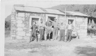 Halls Gap & Grampians Historical Society
Photograph - B/W
It is believed that the three stone cottages in the area were built c.1930 by Italian stonemasons. This cottage is a single room with open fireplace at one end. A hole was dug in the floor inside which a small drum was sunk and covered by a wooden lid. It served as a cool box for the storage of perishable food. It is not known when the cottage was last occupied but during the 1970s the drum was removed and the pit filled in for safety reasons. Photo shows 6 men standing in front of stone cottage at Heatherlie (Mt Difficult) quarry. Cottage made from sawnand off-cuts of stone with stone window frames and door lintel. Rough bush-pole awning at right hand end of cottage.houses, mt difficult quarry -
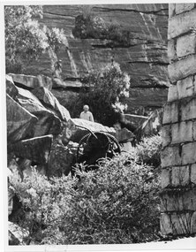
 Halls Gap & Grampians Historical Society
Photograph - B/W, C 1930s
Heatherlie quarryHeatherlie Quarry - Photo shows machinery in quarry; man in bottom right corner Mr F.R. Fameco of 'Heatherlee' Ararat at the Heatherlie Quarries Halls Gap written on backmining, mt difficult quarry -
 Halls Gap & Grampians Historical Society
Photograph - B/W, C 1960s (?)
Heatherlie quarryHeatherlie Quarry - Photo shows Stone-mason's cottage in a state of disrepair and before renovations. Building has no roofquarrying, mt difficult quarry -
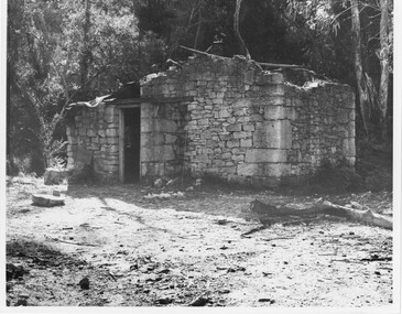 Halls Gap & Grampians Historical Society
Photograph - B/W, C 1960s (?)
Heatherlie QuarryStone-mason's hut Heatherlie Quarry - Photo shows Stone-mason's cottage in a state of disrepair and before renovations. Building has no roofquarrying, mt difficult quarry -
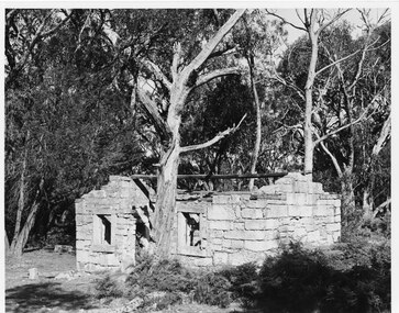 Halls Gap & Grampians Historical Society
Photograph - B/W, C 1960s (?)
Heatherlie quarryStone-mason's hut Heatherlie Quarry - Photo shows Stone-mason's cottage in state of disrepair and before renovations. Building has no roof; gumtree stands in centre foreground quarrying, mt difficult quarry -
 Halls Gap & Grampians Historical Society
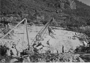
Photograph - B/W, C 1955
This copy b/w - other 2 copies catalogued separately (both coloured) Heatherlie quarry Heatherlie quarry - Photo shows 2 people standing in quarry. Machinery; in foreground; rock-face middle distancequarrying, mt difficult quarry -
 Halls Gap & Grampians Historical Society
Photograph - Coloured, 1955
Heatherlie QuarryHeatherlie Quarry - Photo shows 2 people standing in quarry. Machinery in foreground; rock-face middle distancequarrying, mt difficult quarry -
 Halls Gap & Grampians Historical Society
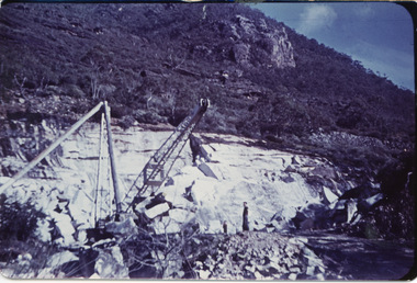
Photograph - Coloured, 1955
Heatherlie QuarryHeatherlie Quarry - Photo shows 2 people standing in quarry. Machinery in foreground. Rock-face middle distancequarrying, rocklyn -
 Halls Gap & Grampians Historical Society
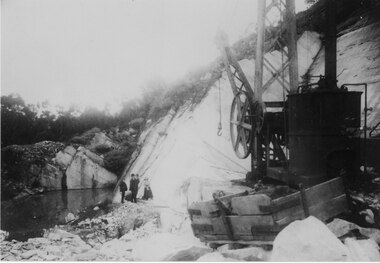
Photograph - B/W, C 1900s
... 117-119 Grampians Road Halls Gap grampians QUARRYING Mt ...Heatherlie quarry - Photo shows a large piece of equipment front right. Three men & a woman standing in front of rock wall. Pool of water middle leftquarrying, mt difficult quarry -
 Halls Gap & Grampians Historical Society
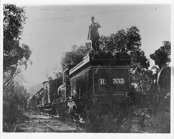
Photograph - B/W, C 1882
Occasional picnic trains took large groups of visitors to the base of the mountain range & sometimes as far as the quarry. Other journeys terminated at Fyans Creek station on the south side of Mt Dryden. Most trips were Sunday School & Church outings, some on the annual Good Friday picnic. Spring was also a popular timePhoto shows train at siding. Man standing on engine roof with bucket in hand; woman in right hand corner of photo looking on; passenger looking out of open doorway. R333 written on back of engine car. Engine turned back to fronttransport, trains