Showing 164 items matching "right to occupy"
-
 Linton and District Historical Society Inc
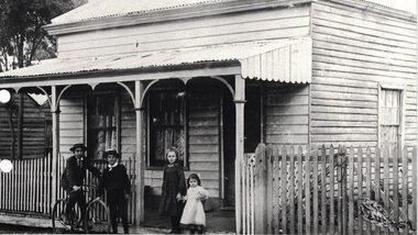
Photograph, The Todd House in Sussex Street, Linton, early 1900s
The Todd family lived in this house in the early 1900s. The house was next door to the butcher's shop which was run by members of the Todd family at the time. Stella Todd is the small child on the right of the photograph, whose hand is being held by her older sister (who is possibly Millie Todd). It is believed this house later burned down and was replaced by the house which currently occupies the site (65 Sussex Street).Black and white copy of original photograph which shows a weatherboard house with a front verandah and a picket fence. Two boys, one on a bicycle, and two girls, the older holding the younger's hand, are posing for the photograph in front of the fence.houses, todd family, stella todd -
 Warrnambool and District Historical Society Inc.
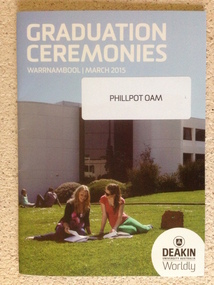
Booklet - Deakin University Warrnambool Graduation Ceremonies 2015, 2015
Deakin University was established in 1974 as the fourth university in Victoria. It has a number of campuses around the state including Warrnambool where it merged with The Warrnambool Institute of Advanced Education in 1990. The university was named after Alfred Deakin, three times Prime Minister of Australia and leading figure in the process of Federation in Australia. Each year a number of students graduate from the Warrnambool Campus which is located on the Eastern edge of Warrnambool on the banks of the Hopkins River. In 2015, there were graduands from the faculties of Arts and Education, Business and Law, Science and health. Deakin University occupies an important educational position In Warrnambool and district. This program contains the names of the many people associated with the university and the graduating students for the year 2015. Photograph of two students sitting on lawn in front of grey building. Text in white at top of cover.Back cover green with white text. "Phillpot OAM" on sticker on front cover. Deakin logo on bottom right corner of front cover.deakin university warrnambool, deakin university graduation 2015 -
 Linton and District Historical Society Inc
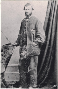
Photograph, John O'Meara on his Wedding Day
John O'Meara on his Wedding Day, August 1865. Born 1833, Tipperary, Ireland. Son of Patrick O'Meara and Ann O'Brien. Married Maria O'Brien. Died 11 Nov 1910. J.J. O'Meara. According to the first Lands Dept. plan of the area, a J.J. O'Meara is shown as owner of lot 13 in Sussex Street, Linton, which is part of the block now occupied by the Shire Offices. In an early Post Office Directory (1868), J.J. O'Meara is listed as "Timber Merchant", Sussex Street, Linton.Black and white copy of original portrait showing a man, standing with his right hand resting on the back of a chair. He is wearing a light coloured suit, white shirt and dark bow tie. His left hand is in the pocket of his jacket, which is done up with a single button on the top of the jacket. A wall and curtain in the background. His hair sticks out at the sides and he has a beard and mustache."John O'Meara".john o'meara, j.j. o'meara, weddings -
 Glenelg Shire Council Cultural Collection
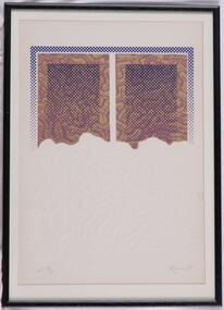
Print, Rod Ewins, (Brain coral), 1977
Print Council of Australia Members' Print Commission, 1977.Screenprint and embossed print. Screenprinted image is in upper 1/2 of print. Two rectangular prints in gold and mauve in abstract pattern. Overlaying these is a royal blue dotted print, framing top and sides of gold and mauve print. Over centres of gold and mauve prints are rectangles of royal blue dots, giving appearance of Benday dots, or mesh screen. The density of this mesh fades gradually from top to bottom. The bottom edge of the screenprints are undulating, meeting the upper edge of the embossing that occupies remaining lower area of the print. The embossing is the same pattern as in the mauve and gold screenprint above. Mounted in pale cream matt. In black painted wodden frame, with glass.Front: A. P. VIII/X (lower left) Ewins 77 (lower right) (pencil) Back: 1978 (upper left, pencil) -
 Stawell Historical Society Inc
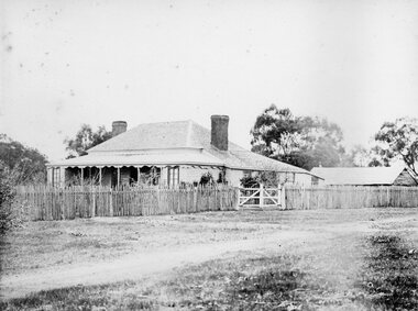
Photograph, Concongella Home Station 1866
Concongella Home Station. Part of a collection of Photographs by Mr. O.G. Armstrong as commissioned by the Shire of Stawell for the Inter-colonial and Paris Exhibition in Melbourne in 1866. The Concongella Station consisted of 57,000 acres along the Concongella Creek. It was first part of Allanvale, taken up by John Allan in 1841. Allen's right to the 137,000 acres of Allanvale was contested and as a result, the northern section of 57,000 acres was renamed Concongella. Concongella Run, with the homestead on the creek of the same name just east of Stawell, occupied the lands between the later named Deep Lead and Great Western. It was on this station that William McLaughlin a sheep minder discovered gold at Pleasant Creek in 1853. Doctor Blundell held Concongella under licence at this time and through until 1858. The homestead has been gone for many years and only some lonely graves remain at this vicinity. stawell -
 Ringwood and District Historical Society
Photograph, Original Ringwood Police Station built 1888. c1973
Black and white photograph of weatherboard and brick building. Typed under photograph: "Original Ringwood Police Station (brick building). 32 Mt Dandenong Road. (Police Station 1888)." Written on rear of backing sheet: "Right hand building was first station. Site cost £20 in 1888. Mtd Const. Waters first to occupy it. Building and land sold 1974 for $20000. 32 Mt. Dandenong Road." -
 Ringwood and District Historical Society
Photograph, Britten Family and home. Warrandyte Road, Ringwood. c1907
Black and white photograph of family group at rear of house. (2 copies- 1 large, 1 small). Small copy mounted on cardboard backing.Typed under large photograph, "Britten Family and home (site became Church of England, Warrandyte Road). Note log walls and rain-water barrel at this pioneer home. c 1907." Written on rear of small photograph: "Wm Grace (1876), James Claridge (1880s) C.G. Britten (1905). All occupied this cottage on site now Church of England vicarage, Warrandyte Rd. Ringwood. Group from left. C.G. Britten holding daughter (Muriel) with son (Reg) on his right. His wife (nee Ethel Banks, Claridges' granddaughter) at rear with her sister in front, and brother Wally on extreme right. (Back of house)." -
 Stawell Historical Society Inc
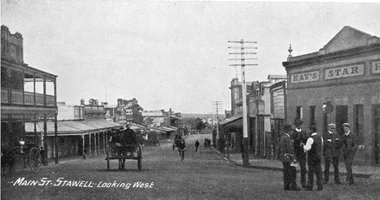
Photograph, Main Street Stawell looking West c1907. Kay's Star Hotel on Right
Main Street Looking West. Kays Star Hotel c1907 The Star Hotel had a chequered life. Like a number of other hotels it started life on Commercial Street Pleasant Creek, the first License being held by Mr. William Francis in 1858. It was shifted to Main Street Quartz Reefs in 1860 and had many tenants over a long period. For many years it stood in the centre of the roadway in Main Street and had to be moved to give more room for traffic. It is one of the reasons we have a bend in the Main Street. As a Hotel it had 54 years without a conviction against it. Although it had many licensees it was owned by one family for the last 27 years of its life as a Hotel. It was delicensed in 1916 because it was too close to the Albion which was a better building. Currently (2025) occupied by the Stawell Club and is licensed. The walkway beside it to the carpark is names Star Lane.Main Street Stawell looking West c1907. Bull & Mouth Hotel with verandahs on Left, Kay's Star Hotel on Right. Group of men talking in roadway at right. Telegraph pole prominent near centre of photo.Main St. Stawell Looking West.stawell, hotel -
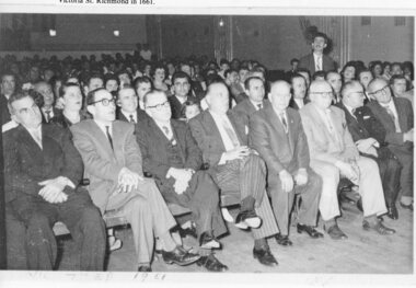 Ithacan Historical Society
Photograph, Greek National Day, 25 March 1961
The photograph was taken at a gathering held at the Victoria Theatre in Victoria Street Richmond in 1961. The function was held to celebrate 25th March Greek National Day. Seated in the front row second from the left with other dignitaries is Stathi Vlass who was Secretary of Melbourne's Greek Community during the 60s. He was also president of the Ithacan Philanthropic Society 1957 - 1959. Fifth from the left is Stathi's uncle, Spiros Raftopoulos who was the President of the Greek Returned Soldiers. Important national days for the Greek community are the 25 March and 28 October. 25 March commemorates the start of the Greek Revolution of 1821; it honors the Greeks' fight for freedom after being occupied by the Ottoman Empire for over 400 years. The 28th of October, known as OXI day (NO day) commemorates the rejection by Greek Prime Minister Ioannis Metaxas of the ultimatum made by Italian dictator Benito Mussolini on 28 October 1940 with a resounding NO. Subsequently Italy invaded Greece but were successfully repelled by the Greeks, delivering one of the first allied victories. However, this was met with a forceful and immediate response when In April 1941 Germany invaded Greece. Greek resistance fighters — a combination of right and left wing partisan groups — mounted a sustained guerrilla war throughout the 4 year occupation. Greece suffered 400,000 casualties during the occupation.A copied black and white photograph of a group of people seated in a large auditorium. CELEBRATION OF THE GREEK NATIONAL DAY HELD IN THE VICTORIA THEATRE/ VICTORIA ST. RICHMOND IN 1661(incorrect date) vlassopoulos -
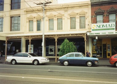 Ithacan Historical Society
Photograph, Clarendon Street, South Melbourne, 1994
Anthi Chilianis is standing to the right of the building, located in Clarendon Street, South Melbourne, which her family occupied and operated as a fruit shop from 1935 to 1945. When the photograph was taken in 1994 the building functioned as a Commonwealth Bank. The verandah across the front is an original structure. There was an upstairs residence where the Chilianis family lived from 1939 to 1945. It was the ninth house that Anthi had lived in since she arrived in Melbourne. A coloured photograph of a cream building occupied by the Commonwealth Bank in a shopping centre with a lady standing on the extreme right.ithacan businesses -
 Lakes Entrance Historical Society
Photograph, Mechanics Hall Lakes Entrance Victoria, 1992 c
Colour photograph showing the back entry to the Mechanics Hall before demolition, room to the left of stairs occupied by Lakes Entrance Family History Group and to the right by Tambo Shire Historical Society Lakes Entrance Victorial. Also colour photograph of main entry to Mechanics Institute Hall and Library extension taken in 1998 halls, public utilities -
 Bendigo Historical Society Inc.
Document - MCCOLL, RANKIN AND STANISTREET COLLECTION: INDENTURE BETWEEN KING EDWARD VIII AND MONUMENT HILL CONSOLIDATED MINE, 2/09/1936
Indenture document number 10878, Vol 317 Folio 35044. Foolscap 4 pages including a map, dated 2nd September, 1936, between King Edward VIII (Crown land) and Monument Hill Consolidated (Bendigo) No Liability 'carrying on operations in the Parish of Sandhurst, to occupy and use the land demised as a site for machinery buildings and offices to be used in connexion with 'mining purposes' ' Document signed by Right Hon William Charles Arcedeckne, (Baron Huntingfield) and J. Stanistreet, Manager, affixed with the Common Seal of Monument Hill Consolidated (Bendigo) No Liability. Map drawn on dark buff paper, and fixed to document. Map shows lease 10878 in the Mining District of Bendigo, Parish of Sandhurst, County of Bendigo. N.Area 2.2.24 ( 2 acres, 2 roods, 24 perches ) Lease site on Rowan Street, bordered by Ophir Street. Coloured in purple on plan with small red area. On bottom: ' Note Red Areas Excised. Scale 4 chains to 1 inch, M.M. Var. 8 degrees 32' E. On lease site, New Chum Gully marked, W.B. House, and Permanent Occy. marked on red area. On last page ownership of lease details from 1937 to 1942.bendigo, mining, monument hill consolidated, common seal of monument hill consolidated, nell gwynne mine, south nell gwynne gold mining company, bendigo mine, ophir street, rowan street, mackenzie street.indenture vol 317 fol. 35044. j stanistreet. -
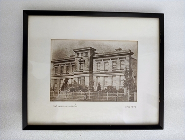 Royal Australian and New Zealand College of Obstetricians & Gynaecologists (RANZCOG)
Photograph - Reproduction photograph, Charles Nettleton (1826-1902), The Lying In Hospital, circa 1870, c. 1868
This a cropped reproduction of a photograph taken by Charles Nettleton in c. 1868. Founded in 1856, the Lying-in Hospital was the second hospital to be established in Melbourne, after the Melbourne Hospital. It was, however, the first lying-in hospital in the Australasian colonies. The hospital was founded in a converted private house "Fairmont", which was located at 41 Albert Street, Eastern Hill (now East Melbourne). In 1858, the 'Lying-in Hospital' was relocated and opened in Madeline St, North Melbourne (now known as Swanston St, Carlton)." (The Women's) The building pictured here was eventually demolished in 1938 to make way for further extensions to the building. The original site in Albert Street was demolished in 1960, and the site is now occupied by the Melbourne Fire Brigade. A section of the wrought iron gates from the original site in Albert Street is held in RANZCOG's historical collection.Reproduction photograph of the front of a building. The building is three stories high. The lowest floor has eight large windows, with a door at centre, on the front side. One side window can also be seen at bottom right. There is a small flight of stairs leading up to the door. The second floor has eight windows in the same locations as the first floor, plus one additional window at centre instead of a door. The top floor is much smaller, with three small windows facing the front of the building. There are trees in the grounds in from of the building. House and grounds are enclosed behind a fence. There is a gate in the fence opposite the front door. Three figures are visible on the path outside the fence. One is at the centre of the image, and the other two are in the right hand corner. Text printed below image reads 'THE LYING - IN HOSPITAL circa 1870'. The image has been mounted and framed in a black wooden frame. An old display label for this image is attached to the back of the frame. handwritten text on backing board at back of work reads 'Probably prior to 1867 (J. Nattrass, 1968). Tape residue visible on backing board at upper right. A chain and two hooks have been added to the frame for hanging. -
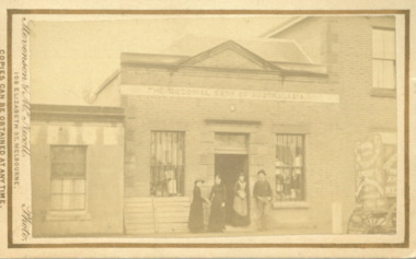 Bacchus Marsh & District Historical Society
Photograph, Shop next to Royal Hotel Main Street Bacchus Marsh 1883
The building in this image was built by J. I. Murray for use as a Bank premises. The National Bank of Australasia opened a branch in the building in 1862 and remained there until 1865. The Colonial Bank of Australasia then occupied the building from 1865 until 1872. At the time this image was taken in 1883 the building was in use as a shop, although a sign saying 'National Bank of Australasia' could still be seen on the building. Goods for sale can clearly be seen in the windows and the photographers’ wagon or cart can be partly seen to the right of the picture. At a later stage the building became part of the Royal Hotel which can be seen to the right of the building. The small building to the left of the picture was used as a printing office by the West Bourke and South Grant Guardian newspaper between 1865 and 1872.Small sepia unframed photograph on card with gold border framing photograph. Housed in the album, 'Photographs of Bacchus Marsh and District in 1883 by Stevenson and McNicoll'. The image shows a shop in Main Street Bacchus Marsh in 1883. Goods for sale can be seen in the windows but there is no signage on the building to indicate what type of shop it is. A sign across the upper facade reads 'Colonial Bank of Australasia' but this bank had vacated this location by 1872. Three women and a man can be seen standing in front of the shop. Two of the women appear to be shaking hands. The woman standing in the doorway is wearing an apron and may be the shop owner or assistant. Just visible at the edge of the photo can be seen a buggy with advertisements on the back and side. Letters that can be distinguished suggest that in all probability this is the carriage used by Stevenson and McNicoll, Photographers, on their trips around rural towns and countryside. On the front: Stevenson & McNicoll. Photo. 108 Elizabeth St. Melbourne. COPIES CAN BE OBTAINED AT ANY TIME. On the back: LIGHT & TRUTH inscribed on a banner surmounted by a representation of the rising sun. Copies of this Portrait can be had at any time by sending the Name and Post Office Money Order or Stamps for the amount of order to STEVENSON & McNICOLL LATE BENSON & STEVENSON, Photographers. 108 Elizabeth Street, MELBOURNE. stevenson and mcnicoll 1883 photographs of bacchus marsh and district, shops bacchus marsh vic., banks bacchus marsh vic., commercial vehicles