Showing 786 items
matching stone house
-
 Marysville & District Historical Society
Map (Item) - Tourist and business map, Narbethong Community and Tourism Group, the Gateway TOURIST AND BUSINESS MAP, 08-2009
A tourist and business map of Narbethong, Buxton, and Taggerty. This map was produced by the Narbethong Community and Tourism Group Inc in August 2009. It was produced to promote the natural attractions, adventure activities, and food trail from the Black Spur, through Narbethong, Buxton, and Taggerty.A tourist and business map of Narbethong, Buxton and Taggerty.This publication has been produced by the Narbethong Community and Tourism Group Inc./ (NCTG) The information provided in this publication has been supplied by the individual/ members. NCTG takes no responsibility for its accuracy./ August 2009narbethong, buxton, taggerty, victoria, australia, tourist and business map, the gateway tourist and business map, black spur motel & caravan park, woodlands rainforest retreat, chestnut glade, black spur inn, wombat cottage, abbey lake luxury b&b spa cottages, camp narbethong, marapana farm stay b&b, mantirri b&b, little dene garden cottages, nareen cabins, silverstream b&b cottages, buxton hotel motel, south cathedral farm luxury b&b cottages, cathedral view b&b retreat, kingbilli country estate, cathedral valley farm, pinjarra gardens, willowbank at taggerty, sarsens rest, yarrolyn caravan park, danico design counted cross stitch, things of sand & stone, buxton zoo nursery, safetrek 4wd services, mystic mountains ski hire & outdoors, pnl 4wdriving, buxton trout and salmon farm, buxton bait and tackle, black spur roadhouse, tudor lodge service station roadhouse & ski hire, buxton roadhouse, buxton p.o. general store, igloo roadhouse, henry v111 manor house, buxton hotel, butters cafe, wagtail wines, little river wines, narby eggs, marapana agistment park, carmyle farm, hazelwood hazelnuts, cathedral view naturall therapies, cre8ing growth, linda hailey, naby cabinets, gb timber, narbethong timber & trading, rb automotive repairs, buxton car care, martyn slade building design, taggerty vet clinic -
 Marysville & District Historical Society
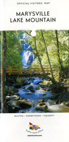
Map (Item) - Tourist map, Mystic Mountains Tourism, OFFICIAL VISITORS' MAP MARYSVILLE LAKE MOUNTAIN, Unknown
A visitors' map of Marysville and Lake Mountain produced by Mystic Mountains Tourism for Visit Victoria.A visitors' map of Marysville and Lake Mountain produced by Mystic Mountains Tourism for Visit Victoria.The Marysville and Lake Mountain Visitor Map and Touring Guide has been compiled and/ published by Mystic Mountains Tourism Inc. Copyright./ Production and artwork Graph Attack P/Lmarysville, lake mountain, victoria, australia, visitor's map, official visitors' map marysville lake mountain, buxton, narbethong, taggerty, visit victoria, mystic mountains tourism inc, graph attack p/l, mystic mountains, marysville triangle, marysville visitor information centre, marylands country house, black spur, steavenson falls, lady talbot drive, cambarville, cathedral ranges, wirreanda festival, lake mountain summit walk, summit walk loop, leadbeaters loop, day loop walk, buxton hotel, igloo roadhouse, karmann waters, silverstream b&b cottages, buxton trout and salmon farm, the niche wine bar, buxton post office & general store, choppers buxton roadhouse, woodlands rainforest bungalows, chestnut glade, black spur inn, wombat cottage, abbey lake luxury b&b spa cottages, mystic mountain ski hire & outdoors, pnl 4wdriving, blue views holiday units & ski hire, marapana agistment park & farm stay b&b, danico design, things of sand & stone, mantirri blueberry farm, allawah country cottages, amberview cottages, ashlar cottage b&b, black spur motel & caravan park, blackwood deluxe cottages, blackwood courtyard b&b, dalrymples guest cottages, delderfield, el kanah guest house, fruit salad farm, kerami guest house, keppels hotel, lake mountain-snow gum lodge, lomatia lodge, lyell guest cottages, magnolia house, keppel waters, lyrebird apartments, marysville caravan park, all view spa apartments, riverside cottages, maryton park b&b country cottages, melina cottage, mountain lodge, mystic mountains holiday cottages, nanda binya lodge, rendezvous luxury cottages, scenic b&b motel, the cumberland, south cathedral farm, tower motel, willowbank at taggerty, woodlands rainforest retreat, marysville & district country club inc, mystic mountains ski hire & outdoors, rubicon valley horse riding, marysville trout and salmon ponds, gallipoli park, keppels lookout, cambarville-yarra ranges national park, lake mountain-yarra ranges national park, lady talbot drive-yarra ranges national park, cathedral range state park, steavenson river, taggerty river, acheron river, lake mountain alpine resort, bruno's art and sculpture garden, manical mechanicals, uncle fred & aunty val's old style lolly shop, carmyle farm boutique, crossways historic country inn, fraga's, gilberts restaurant, heights licensed bistro, the old woolshed cafe, cathedral view natural therapies, crystal journey -
 Glenelg Shire Council Cultural Collection
Print - Reduction Linocut, Bob Stone, Working Tug II, c. 2015
Reduction linocut, blue, grey, white, red, green, black; white mount, blondewood frame, reflective glasss. Hanging wire across width of frame, on backFront: '1/7 linocut Working Tug II Bob Stone 2015 Back: Holland's Picture Framing, black stamp, lower left corner -
Glenelg Shire Council Cultural Collection
Domestic object - INKWELL (STONE), n.d
Stone inkwell -
Glenelg Shire Council Cultural Collection
Tool - INKWELL (STONE), Stone Inkwell Writing Tool, n.d
Stone -
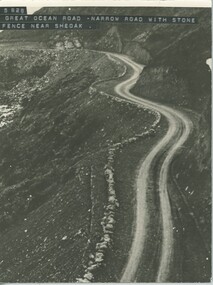 Lorne Historical Society
Photograph - Black and White Photograph, Narrow section of Great Ocean road near Sheoak River
View only black and white photograph showing a narrow section of the Great Ocean Road with stone fence near the Sheoak River -
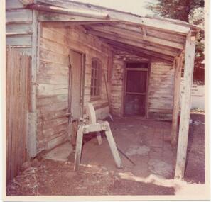 Phillip Island and District Historical Society Inc.
Photograph, 1978/9
... "Rogers Cottage" - photograph showing door to Wash house... showing door to Wash house - note grinder stone in foreground ...Rogers Cottage was built by John Rogers on the hill on Churchill Island in the early 1860s. It is believed he first built the Bakehouse in 1865 and shortly after built the 2 roomed dormitory which was originally lined with calico and plaster - later with hand split boards."Rogers Cottage" - photograph showing door to Wash house - note grinder stone in foreground. Situated on Churchill Island - Western Port.local history, photographs, buildings - historical, rural industry, coloured photograph, john cook, churchill island, rogers cottage -
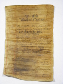 Mortlake and District Historical Society
Document, Mortlake Mechanics' Institute Scroll
In April 1869 when the foundation stone of the Mortlake Mechanics' Institute was laid by Thomas Shaw of Wooriwyrite, this parchment scroll was sealed with other documents in the foundation stone. In 1891 when further alterations were made the hall these documents were retrieved from the stone. This building was erected to house the local library whichup until that time had been housed in the Morllake Common School.Discoloured foolscap parchment with copperplate lettering, some water damage which has caused the obliteration of the names of the Members of the Building Committee, Hon.Secretary and Architect. At a Public Meeting presided over by John Grieve Esq. President of the Shire/The foundation stone/of this building/was laid by - /Thomas Shaw Junior Esquire the President of the Institute on Monday/the 29th day of March A. D. 1869 in the 32nd year of the Reign of Her/Most Gracious Majesty Queen Victoria Sir I. A. T. Manners Sutton/being Governor of this Colony of Victoria/With this Scroll is Deposited/A copy of The Argus Newspaper of 28th March 1869/A copy of The Warrnambool Examiner of ? March 1869/A copy of The Belfast Examiner of 17th March 1869/Members of/The Building/ Committee/Hon.Secretary and Treasurer/Architect/Contractors/Messrs Jenkins and Harvey,Mason/Mr Joseph Wyatt,Carpenter.institute, free, libraries, public buildings, mortlake, mechanics -
 Greensborough Historical Society
Photograph, Main Road bridge looking to township of Greensborough, 1929c
... Avenue and some newer houses below this. The stone river bridge... of the park. Looking up Main Street we see the old Chapman house ...View of Main Street Greensborough from Partington's Hill including Plenty River bridge and Marble Hall on corner of Carter Street (now Para Road) and Main Street. This view of Greensborough Park shows the old pan toilets, the hawthorn fence line and the rather undeveloped roadside area of the park. Looking up Main Street we see the old Chapman house at the corner of Poulter Avenue and some newer houses below this. The stone river bridge appears to be only a single lane wide and the road approaching the bridge is unsealed. The rail bridge shows evidence of soot from steam trains and at the extreme left of picture the two concrete buildings indicate the line had been electrified. This occurred in 1923. Sparse housing is seen in the Flintoff Street and Grimshaw Street area.Part of a collection of photographic enlargements of views of Greensborough in the early 1900s.Black and white enlargement of photographic imagemain street greensborough, marble hall, greensborough railway, chapman house, greensborough park, poulter avenue greensborough, carter street, para road -
 Glenelg Shire Council Cultural Collection
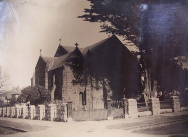
Photograph - Photograph - St. Stephens Church, Portland, 1934
Photographs taken by Esther Winifred Hall (nee Smallpage) - great grand-daughter of Stephen George Henty. Taken in 1934 Centenary Celebrations in Portland.Black and white photograph showing stone building (church) in shade of tree with stone fence and iron gate in foreground. Crosses attached to roof of building.Front: (no inscriptions) Back: St. Stephens Church Portland. New fence erected for Centenary 1934.esther winifred hall, portland centenary, 1934, henty -
 Glenelg Shire Council Cultural Collection
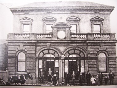
Photograph - Photograph - Post Office, Portland, n.d
Black and white reproductive photograph of earlier image. People standing in front of Post Office building - double storey bluestone with decorative stone balcony.Front: Post Office, Portland (on photograph original). Portland Post Office Cnr Bentinck & Cliff Streets c1900 (built 1991) (typed label, lower centre). Back: B21766/98 (pencil, upper left). State Library of South Australia Photographic Section. Order No. A16493 (stamp, centre).portland post office -
Glenelg Shire Council Cultural Collection
Artwork, other - Linocut Print - Seventh in a suite of 16 in the Admella Rescue Series, Admella Rescue Series, 2009
See 5377Linocut print. Seventh in a suite of 16 in the Admella Rescue Series. Depicts two people holding on to one another. Reaching out to another person whose left hand and forearm only are visible. All surrounded by waves. Printed in black on white archival paper. -
Glenelg Shire Council Cultural Collection
Print - Linocut - Admella Rescue Series No. 16, Bob Stone, 'Exposed for a whole week without shelter - clinging to the bulworks for very life....' Portland Guardian, 15th August 1859, 2009
Part of suite of 16 Linocuts created for an exhibition at the Portland Arts centre for the Admella 150th Festival.Linocut print. Sixth in a suite of 16 in the Admella Rescue Series. Shows head and shoulders and right arm of man on Admella, holding the hand of someone in the sea. Two bands and forearms of another person in the the sea reaching up. Printed in black on white archival paper.Front: Front - Linocut, Bob Stone 'Exposed for a whole week without shelter - clinging to the bulworks for very life....' Portland Guardian, 15th August 1859 - hand written in black penadmella, shipwreck, portland lifeboat -
Glenelg Shire Council Cultural Collection
Print - Linocut - Admella Rescue Series No. 4, Bob Stone, Some valuable horse stock was on board .... the horses were thrown overboard.... SA Advertiser 7th August 1859, 2009
Part of suite of 16 Linocuts created for an exhibition at the Portland Arts centre for the Admella 150th Festival.Linocut print. Fourth in a suit of 16 in the 'Admella Rescue Series'. Depicts the head of one horse, and the head and one forelegg of the second horse, among large waves. Printed in black on white archival paper.Front: Front - Linocut Bob Stone 'Some valuable horse stock was on board .... the horses were thrown overboard.... SA Advertiser 7th August 1859' - hand written, black penadmella, portland lifeboat, shipwreck -
Glenelg Shire Council Cultural Collection
Print - Linocut - Admella Rescue Series No. 3, Bob Stone, '..... they were four hours amongst the rocks and breakers before they got ashore' - SA Advertiser 20th August 1859', 2009
Part of suite of 16 Linocuts created for an exhibition at the Portland Arts centre for the Admella 150th Festival.Linocut Print. Third print in suite of 16 in the Admella Rescue Series. Shows two men on rocky shore, rough sea in background. One man on hands and knees, the other, still in water, holding a long box. Printed in black on white archival paper.Front: Front - Linocut Bob Stone 2009 '..... they were four hours amongst the rocks and breakers before they got ashore' - SA Advertiser 20th August 1859' - handwritten, black penadmella, shipwreck, portland lifeboat -
Glenelg Shire Council Cultural Collection
Print - Linocut - Admella Rescue Series No. 6, Bob Stone, A public meeting was held to raise a fund for the relief of the survivors. Portland Guardian 26th August 1859, 2009
Part of suite of 16 Linocuts created for an exhibition at the Portland Arts centre for the Admella 150th Festival.Linocut. Sixteenth in a suite of 16 in the Admella Rescue series. Printed in black on white archival paper. Depicts a group of 6 people, one of whom is addressing a crowd of people.Front: 'Linocut Bob Stone 2009' A public meeting was held to raise a fund for the relief of the survivors. Portland Guardian 26th August 1859 - hand written, black penadmella, shipwreck, portland lifeboat -
Glenelg Shire Council Cultural Collection
Print - Linocut - Admella Rescue Series No. 16, Bob Stone, 'Four heavy seas struck ... washing one man overhead, who was, however, picked up. Portland Guardian 18th August 1859', 2009
Part of suite of 16 Linocuts created for an exhibition at the Portland Arts centre for the Admella 150th Festival.Linocut. Tenth in a suite of 16, in the Admella Rescue series. Depicts Portland lifeboat. 3 crew members leaning leaning over sid eof life boat towards someone in water. Printed in black on white archival paper.Front: Linocut, Bob Stone. ...'Four heavy seas struck ... washing one man overhead, who was, however, picked up. Portland Guardian 18th August 1859' - Handwritten, black penadmella, shipwreck, portland lifeboat -
Glenelg Shire Council Cultural Collection
Print - Linocut - Admella Rescue Series No. 12, Bob Stone, The boat at times appeared to stand up perpendicular on a wave that rose up like a wall, 2009
Part of suite of 16 Linocuts created for an exhibition at the Portland Arts centre for the Admella 150th Festival.Linocut. Twelth in a suit of 16 in the Admella Rescue Series. Printed in black on white archival paper. Depicts Portland lifeboat being rowed through heavey seas.Front: Linocut Bob Stone 2009 The boat at times appeared to stand up perpendicular on a wave that rose up like a wall. 'SA Advertiser 20th August 1859' - Black pen, hand writtenadmella, shipwreck, portland lifeboat -
Glenelg Shire Council Cultural Collection
Print - Linocut Admella Rescue Series No. 15, There was much celebration when the survivors were taken off the 'Lady Bird', 2009
Part of suite of 16 Linocuts created for an exhibition at the Portland Arts centre for the Admella 150th Festival.Linocut. Fifteenth in a suit of 16 in the Admella Rescue Series. Printed in black on white archival paper. Depicts band playing in street, by standers each side.Front: 'Linocut Bob Stone 2009 There was much celebration when the survivors were taken off the 'Lady Bird' - Hand written, black pen.admella, shipwreck, portland lifeboat -
Glenelg Shire Council Cultural Collection
Print - Linocut - Admella Rescue Series No. 14, Bob Stone, on arrival at Lady Bird some 3 or 4 were in the last stage of existence 'Portland Guardian 15th August 1859', 2009
Part of suite of 16 Linocuts created for an exhibition at the Portland Arts centre for the Admella 150th Festival.Linocut. Fourteenth in a suite of 16 in Admella Rescue Series. Printed in black on white archival paper Depicts a man with a rope around his chest and under his arm pits, being hauled up the side of the 'Lady Bird'. Two members of the Portland life boat also visible, watching procedure from lifeboat.Front: 'Linocut Bob Stone 2009 ... on arrival at Lady Bird some 3 or 4 were in the last stage of existance. Portland Guardian 15th August 1859' - hand written in black ink.admella, portland lifeboat, shipwreck -
Glenelg Shire Council Cultural Collection
Print - Linocut - Admella Rescue Series No. 8, During the night the Portland lifeboat was launched, 2009
Part of suite of 16 Linocuts created for an exhibition at the Portland Arts centre for the Admella 150th Festival.Linocut print. Eighth in a suit of 16, of the Admella Resue Series. Depicts a man with a lantern, standing in the bow of the Portland Lifeboat, as it is being launched by several men with ropes. Printed in black on white archival paper.Front: Front - Linocut, Bob Stone 2009 'During the night the Portland lifeboat was launched.' - hand written, black penadmella, portland lifeboat, 150th anniversary, linocut -
Glenelg Shire Council Cultural Collection
Print - Linocut - Admella Rescue Series No. 13, Bob Stone, Help had reached the sufferers at last... Every heart will rejoice over this good news Portland Guardian 11th August 1859, 2009
Part of suite of 16 Linocuts created for an exhibition at the Portland Arts centre for the Admella 150th Festival.Linocut. Thirteenth in a suite of 16 in the Admella rescue series. Printed in black on white archival paper. Depicts 3 men on Admella, with a rope from them to the Portland lifeboat.Front: 'Linocut Bob Stone, 2009 Help had reached the sufferers at last... Every heart will rejoice over this good news Portland Guardian 11th August 1859' - Handwritten, black ink.admella, shipwreck, portland lifeboat -
Glenelg Shire Council Cultural Collection
Print - Linocut - Admella Rescue Series No 2, Bob Stone, Poor George Fisher was one of the first swept away.... SA Advertiser 20th August 1859, 2009
Part of suite of 16 Linocuts created for an exhibition at the Portland Arts centre for the Admella 150th Festival.Linocut print. Second print in suite of 16 in the 'Admella Rescue Series. Depicts a hand rising from the sea. Printed in black on white Archival paper.Front: Front - 'Linocut Bob Stone 2009 - Hand written, black pen. 'Poor George Fisher was one of the first swept away.... SA Advertiser 20th August 1859' -
Glenelg Shire Council Cultural Collection
Print - Linocut Admella Rescue Series No. 5, Bob Stone, Many a heart will bleed to think of what must have been suffered, 2009
Part of suite of 16 Linocuts created for an exhibition at the Portland Arts centre for the Admella 150th Festival.Linocut print. Fifth in a suite of 16, in the Admella Rescue Series. Depicts 5 distressed people on the deck of the Admella, surrounded by rough seas. Printed in black on white archival paper.Front: Front - Linocut Bob Stone Many a heart will bleed to think of what must have been suffered.... SA Advertiser 9th August 1859 - handwritten, black penadmella, shipwreck, portland lifeboat -
Glenelg Shire Council Cultural Collection
Print - Linocut - Admella Rescue Series No. 11, Our telegrams were passed from hand to hand being read aloud.' SA Advertiser 9th August 1859.', 2009
Part of suite of 16 Linocuts created for an exhibition at the Portland Arts centre for the Admella 150th Festival.Linocut. Eleventh in a suite of 16 in the Admella Rescue series. Printed in black on white archival paper. Depicts man reading telegram to group of men and women.Front: 'Linocut, Bob Stone Our telegrams were passed from hand to hand being read aloud.' SA Advertiser 9th August 1859.' - hand written, black penadmella, portland lifeboat, shipwreck -
Glenelg Shire Council Cultural Collection
Print - Linocut - Admella REscue Series No. 9, Bob Stone, 'She (The Portland Lifeboat) rode most splendidly over the high waves' Portland Guardian 2nd September 1859, n.d
Part of suite of 16 Linocuts created for an exhibition at the Portland Arts centre for the Admella 150th Festival.Linocut print. Ninth in a suite of 16, in the Admella Rescue Series. Depicts Crew rowing the Portland lifeboat through rough seas. Printed in black on white archival paper.Front: Front - Linocut, Bob Stone 2009 'She (The Portland Lifeboat) rode most splendidly over the high waves' Portland Guardian 2nd September 1859 - hand written, black pen.admella, portland lifeboat, shipwreck -
Glenelg Shire Council Cultural Collection
Book, Shire of Portland By-Laws and Regulations, 1960s
Book of 38 pages, white paper, black print, covers made of mauve and grey cobble - stone pattern cardboard. Front cover has red lined strip on left hand side. Three round brass fasteners holding book together.local government, shire of portland, laws, regulations, portland -
Glenelg Shire Council Cultural Collection
Print - Print, reproduction, F. W. Birmingham, Map of the town of Portland in the colony of Victoria, 1853
Town of PortlandFramed illustration of a map of the Town of Portland from a stone etching published by F.W. Birmingham, Dec.1853. Mounted and framed in stained black timber frame under glass.Front: (no inscriptions) Back: (no inscriptions) -
Glenelg Shire Council Cultural Collection
Photograph - Photograph - Glass Sided model wave tank, n.d
Port of Portland Authority archives.port of portland archives -
 Glenelg Shire Council Cultural Collection
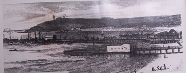
Photograph - Photograph - Portland Wharf prior to 1890, n.d
Whaler's Bluff lighthouse in Portland was originally located on Battery Point. It was erected there in 1859. In 1889 it was relocated, stone by stone to Whaler's Bluff. The reasoning given was that the space on what is now known as Battery Point was needed for guns and it was also thought that the lighthouse was less open to attack at Whaler's Point.Black and white photo. Lighthouse on Battery Point. Baths in foreground. People on Beach. Sail boats in bay. Pier in Centre.Front: Portland Wharves before 1890. Back: Port of Portland Authority.portland lighthouse, whalers bluff, battery point