Showing 91527 items matching "tambo-shire-history"
-
 Maldon Brass Band Inc.
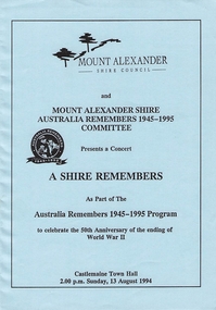
Program, Mount Alexander Shire, A Shire Remembers, 13/08/1994
Mount Alexander Shire Australia Remembers 1945-11995 Committee Presents a concert -
 Linton and District Historical Society Inc
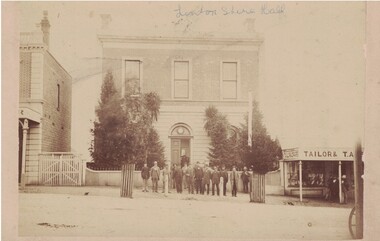
Photograph, Stamped on reverse: Free & Sons, Photographers, Melbourne, Linton Shire Hall
The Shire Hall/offices were completed in the mid 1860s. Dating the photograph: The photograph is thought to have been taken c.1880. An earlier photograph of the Town Hall in the LDHS collection, in which the trees are smaller, is dated 1875. Thomas Austin, who ran a draper's shop next to the Shire offices, left Linton in 1882.Original sepia photograph showing the Grenville Shire Offices (Linton Town Hall). A group of men, thought to be Grenville Shire Councillors, are standing in the street in front of the building, which has several trees growing in front of it, and a low front fence. To the right, a shop has signs on its verandah: "TAILOR & DRAPER" and "TAILOR & T. A. . . ." (thought to read T. Austin). To the left, a higher picket fence or gate separates the Shire Hall from the two-storey building next door. This building is 'Criterion House', built in 1862/1863 by Samuel Steele. The words "Linton Shire Hall" have been inscribed in ink across the top of the photograph.Handwritten in ink across top of photograph: "Linton Shire Hall".grenville shire offices, linton town hall, thomas austin [tailor & drapery store], shire of grenville councillors, linton shire hall -
 Lakes Entrance Historical Society
Book, East Gippsland Shire Council, East Gippsland Shire Fire Prevention Plan June 2003, 2003
Fire Prevention stategy identifying plans to decrease the vulnerability of people and property in the shire with uncontrolled fires East Gippsland Victoriafire brigade, vegetation -
 Orbost & District Historical Society
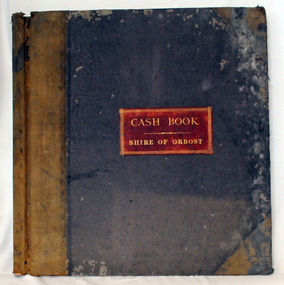
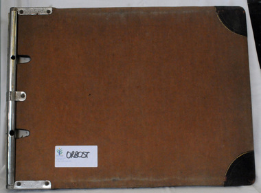
cash book, 1893-1899
This ledger was used by the Shire of Orbost from 1893-1899 . The item was donated to Orbost & District Historical society from P.R.O.V. as a Place of Deposit (POD) item for safe keeping by a local history group or museum. The shire covered an area of 9,347 square kilometres and existed from 1892 until 1994 when it became part of the East Gippsland Shire Council. Orbost was at first included in the Bairnsdale Shire from 1882 and was later part of the Tambo Shire. Because of travelling distances the Croajingalong Shire was created in 1892 (name changed to Orbost Shire 17.2.1893 with James Cameron as the first Shire President. In 1994 it amalgamated to become part of East Gippsland Shire Council This is a handwritten record of the financial transactions of the first Obost Shire Council. This council no longer exists having been absorbed by the East Gippsland Shire Council.A specially printed cash book with a brown cover and lighter brown binding. It has marbled end covers. It contains hand-written accounts of local government transactions .on front inside a red rectangle -"Cash Book Shire of Orbost"cash-book shire-of-orbost accounts -
 Lakes Entrance Historical Society
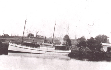
Photograph, The Bellbird on the Tambo River Johnsonville Victoria, 1906 c
Black and white photograph of George Frasers Bellbird on the Tambo River Johnsonville Victoria. Also two colour photographs of some descendants of Duncan and Legg families at Tambo River landing Johnsonvillefishing industry, transport, rivers -
 Camberwell Historical Society
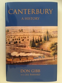
Book, Don Gibb et al, Canterbury: A History, 2019
In this book, Don Gibb presents a history of the development of Canterbury as a suburb up until 1960. Produced by Royal Historical Society of Victoria and Canterbury History Group. Published 2019.camberwell, canterbury -
 Learmonth and District Historical Society Inc.
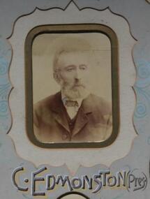
Photo - Edmonston, Richards & Co. Photos Ballaarat, Edmonston, Charles. Shire President 1893 - 1894, 1894 (estimated); Late 19th century
Photo of Cr Charles Edmonston. This photo was taken while Charles Edmonston was the President of the Ballarat Shire. 1893-1894.Section of Original Historical photograph of the Councilors,covering the financial year 1893 to 1894.Sepia Photo of Charles Edmonston,Ballarat Shire President,1893/1894. Located in the centre of a photo of all councilors for that year.Section of a photo from Councilors of the Ballarat Shire. 1893/1894.shire, president, ballarat, edmonston, charles, 1893 1894 -
Stawell Historical Society Inc
Document - Annual Report, Northern Grampians Shire 4 Annual Reports, 1999 - 2006
4 Annual reports of the Northern Grampians shire. Reports for 1999, 2003, 2004-05, 2005-6. Northern Grampians shire Spiral BoundShire Norther Grampiansnorthern grampians shire, stawell -
Bacchus Marsh & District Historical Society
Plaque, Shire of Bacchus Marsh Coat of Arms
Coat of Arms used by the Shire of Bacchus Marsh in the 1980s and 1990s. A coat of arms has been in use in the Shire at least from the early 20th century. This earlier coat of arms described in 1910 featured two cows standing on two bales of lucerne hay, with lucerne fields and fruit trees and rolling hills all round a central valley with two rivers running through it. This early coat of arms was superseded by the slightly different design shown here. When this change took place is not known. When the Bacchus Marsh Shire amalgamated with other Shires to form Moorabool Shire in 1994 this design was superseded.The plaque showing the Bacchus Marsh Shire Coat of Arms is in near perfect condition and as such is an excellent example of the physical symbols used to demonstrate the presence of local government in the Bacchus Marsh region. The images on the coat of arms also depict key economic and agricultural activities in the region which provides historical information about the region in a visual and artistic way.Painted cast bronze plaque with inscription on outer white band in black capital lettering: SHIRE OF BACCHUS MARSH. Inner circle painted blue with shield and decorative branches bearing yellow leaves on either side. Shield quartered and surmounted by stylised sunrise. In four quarters, representations of significant local primary and secondary industries. SHIRE OF BACCHUS MARSH.coats of arms, shire of bacchus marsh -
 Lakes Entrance Historical Society
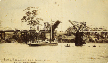
Postcard - Swan Reach Bridge, H D Bulmer, 1908 c
Also a second black and white photograph of Swan Reach Tambo River 05378.1Sepia toned postcard showing the SS Burrabogie about to go through the open left bridge over the Tambo River at Swan Reach VictoriaSwan Reach Bridge Tambo Riverbridges, waterways, boats and boating -
 Linton and District Historical Society Inc
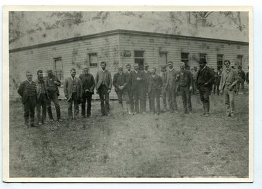
Photograph, Grenville Shire Councillors and council officers outside first Council offices at Linton, 1880s
The Shire of Grenville was proclaimed in 1864. The Shire offices and hall are believed to have been completed by the mid 1860s. Photograph is dated to 1880s from names of Council members and Shire officers.Original sepia photograph showing a group of men standing outside the Shire Council offices at Linton. Photo shows the fence at the front of the Grenville Shire offices, and part of the next-door shop (shop formerly owned by Thomas Austin). Some names of Councillors and Shire officials handwritten on the back of the photograph. The photograph has been sealed in a protective plastic cover.On reverse of photograph: "Wm Brown / J.J. Shepherd / Alex McVitty / Jas Dodds (Shire Secretary) / G.H. Smith / Jno Clarke / W.G. Bennett / Mr Preston".shire of grenville offices, grenville shire hall, buildings, councillors, austin's shop, joseph shepherd, alex mcvitty, james dodds [shire secretary], john clarke, w. g. bennett, mr preston, william brown [shire engineer], linton town hall -
 Eltham District Historical Society Inc
Folder, Shire of Eltham Pioneers Photograph Collection; Application by Yarra Plenty Regional Library for a Local History Grant to digitise collection, 1982-2014
Material pertaining to the production of a history of the Shire of Eltham, "Pioneers & Painters: One Hundred Years of Eltham and its Shire" in recognition of the shire's centenary in 1971 Item Title Caption 04771-1 Shire of Eltham Pioneers Photograph Collection: Application; Local History Grants Program 2012-2013, Yarra Plenty Regional Library, 7 November 2012 04771-2 Shire of Eltham Pioneers Photograph Collection: Local History Grants Program 2012-2013, Yarra Plenty Regional Library, 31 May 2013 04771-3 Notification to Eltham District Histoprical Society of successful application for Local History Grants Program by Yarra Plenty Regional Library, 5 June 2013 04771-4f 04771-5 Media Release, Craig Ondarchie MP announcing a grant of $3,775 for the Shire of Eltham Pioneers Photograph Collection, 3 July 2013 Grant for digitising selected images within the collection 04771-6 Details of negative and prints scanned as part of Local History Grants Project, 23 October 2013 04771-7 Feedback from Eltham Disitrict Historical Society to Local and Family History Librarian, Yarra Plenty Regional Library in support of Local History Grant application to digitise the Shire of Eltham Pioneers Photograph collection, 27 October 2012. The idea to develop a book on the history of the Shire of Eltham to be edited by noted author, Alan Marshall in celebration of the shire's centenary was initiated in 1969. The Shire of Eltham Historical Society undertook significant research in conjunction with Alan Marshall locating material at various institutions and other societies; interviewing longer term residents and a public campaign through the local press to acquire photographic material for duplication and use in the book. The public campaign received generous response and the material collected became the genesis for the Shire of Eltham Pioneers Photograph collection now held in partnership between Eltham District Historical Society and Yarra Plenty Regional Library (Eltham Library). This material covers the application to digitise the bulk of the collection with the assistance of a Local History Grants project made available through Public Records Office Victoria; the result of which was successful and has enable d Eltham District Historical Society and Yarra Plenty Regional Library to embrace a much wider audience from far afield in sharing the local history of the Eltham Shire and Eltham districtPaper documents A4 size; one item laminatedeltham district historical society, local history grants program 2012-2013, public record office victoria (prov), yarra plenty regional library, shire of eltham pioneers photograph collection -
 Orbost & District Historical Society
black and white photograph, late 19th century - early 20th century
Probably taken 1890's before Orbost was separated from Tambo. The Shire of Tambo was a local government area about 320 kilometres east of Melbourne. The shire covered an area of 3,506.86 square kilometres and existed from 1882 until 1994. Tambo was first incorporated as a shire on 6 January 1882, splitting away from the Shire of Bairnsdale. On 30 May 1892 it lost three-quarters of its land area when the Shire of Orbost was incorporated. A small amount was re-annexed as Cunninghame Riding on 3 January 1913. On 2 December 1994, the Shire was abolished, and merged with the City and Shire of Bairnsdale, Shire of Orbost, most of the Shire of Omeo and the Boole Boole Peninsula from Shire of Rosedale into the Shire of East Gippsland. ( more information Newsletter July 2010). This photograph is of Tambo Shire Council meeting at Faithful's Hotel, Nowa Nowa. It includes Snowy River Riding councillors. Mary Stirling, wife of Shire Secretary Thomas Telfer Stirling, took over the Nowa Nowa Hotel from Moses Faithful in 1895. Photograph includes: John Butter BESLEY, John William BORLAND, Charles Begg IRVINE, William J. LAMBOURN, James LARKIN, Ronald McDOUGALL, Donald McRAE, William ROADKNIGHT jnr., David WILLIAMS, James CAMERON, Charles Henry GROVE. (info. John Phillips) This item is associated with the Tambo Shire Council, a local government which no longer exists.A black / white photograph of a group of men standing in a line outside a large timber building.on back - "Tambo Shire Council . Meeting at Nowa Nowa - Stirling's Hotel"tambo-shire-council faithful's-hotel-nowa-nowa local-government -
 Linton and District Historical Society Inc
Photograph, Final Grenville Shire Council meeting 1994
The Shire of Grenville ceased to exist after extensive restructure of local government undertaken by the Kennett government from 1993. Much of the former Shire is now part of the Golden Plains Shire.Colour photograph taken at last Grenville Shire council meeting 05.05.1994"Last Grenville shire council meeting before restructure, at top table l-r Russell Hodges D Nicholl Ken McBeath Bruce Hollioake, standing Fred -- 05.05.1994".grenville shire council, hodges, nicholl, mcbeath, hollioake -
 Orbost & District Historical Society
Invitation, 1969
The current building was opened on Friday 28th February 1969 by the Premier of Victoria, The Hon. Sir Henry E. Bolte, K.C.M.G., M.P. The Shire of Orbost was a local government area about 380 kilometres east of Melbourne, the state capital of Victoria, Australia. The shire covered an area of 9,347 square kilometres and existed from 1892 until 1994. Originally, Orbost was part of the Bairnsdale Road District which was created on 30 April 1867. Splitting away as part of the Shire of Tambo in 1882, Orbost was first incorporated as a shire in its own right as the Shire of Croajingolong on 30 May 1892. It received its present name on 17 February 1893. On 3 January 1913 part of its western riding was annexed to Tambo as its Cunninghame Riding. Local governments play an important role in the lives of citizens in Australia. Local government authorities exist to provide services and amenities to local communities, and are also responsible for regulating and providing services for land and property in their district. This item is representative of a time when Orbost had its own Shire Council. A stapled program and invitation to the official opening of the new Orbost Shire Council Municipal Offices. A light blue card with the Orbost Shire Council insignia and gold print on front. The invitation is addressed to the secretary of Orbost Historical Society Judith Walcott.handwritten in blue pen - "Judith G Walcott"orbost-shire-council -
 Orbost & District Historical Society
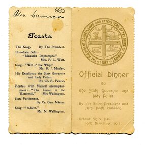
menu, 1912
This item is an invitation to a dinner given by the Shire President and Mrs Hugh Cameron for the State Governor and Lady Fuller to be held in the Orbost Shire Hall on November 19, 1912. The governor and his wife left Melbourne on November 14 on a visit to East Gippsland. Hugh Cameron (1850-1921) was on the Orbost Shire council from 1892-1915. (more info. in O.D.H.S. newsletter -Tambo Shire) The Shire of Orbost was a local government area about 380 kilometres east of Melbourne, the state capital of Victoria, Australia. The shire covered an area of 9,347 square kilometres (3,608.9 sq mi), and existed from 1892 until 1994. Originally, Orbost was part of the Bairnsdale Road District which was created on 30 April 1867. Splitting away as part of the Shire of Tambo in 1882, Orbost was first incorporated as a shire in its own right as the Shire of Croajingolong on 30 May 1892. It received its present name on 17 February 1893. On 3 January 1913 part of its western riding was annexed to Tambo as its Cunninghame Riding. On 2 December 1994, the Shire was abolished, and merged with City and Shire of Bairnsdale, Shire of Tambo, most of Shire of Omeo and the Boole Boole Peninsula from Shire of Rosedale into the Shire of East Gippsland. This item is associated with Orbost Shire Council which no longer exists. It is also associated with Hugh Cameron.A small menu on a cream folded card with blue print. On the front is stamped a large blue logo of the Shire of Orbost. The text is "Official Dinner". On the back is a list of toasts and inside is the menu.On back - handwritten - "Alex Cameron"orbost-shire-council cameron-hugh -
 Lakes Entrance Historical Society
Postcard, Bruthen-Tambo Upper, 1900 c
Sepia toned postcard showing farmland in Bruthen Tambo Upper area Bruthen VictoriaCGRsettlement, agriculture -
 Lakes Entrance Historical Society
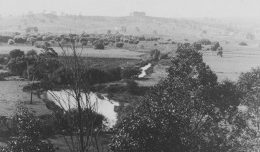
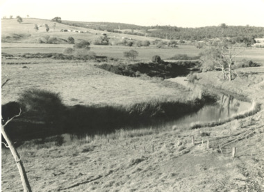
Photograph, G Legg Bairnsdale, Tambo River at Mossiface Victoria, `1970 1980 c
This narrow waterway was the original steamer route to the Port of MossifaceBlack and white photograph of the Tambo River adjoining Arthur Howletts property at Mossiface Victoriaboats and boating, rivers -
 Lakes Entrance Historical Society
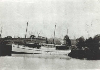
Photograph, SS Bellbird , Tambo River at Johnsonville
Black and white photograph of SS Bellbird after its launch on Tambo River at Johnsonvilletourism, boats and boating, rivers -
 Orbost & District Historical Society
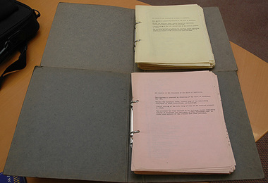
cash book, 1960
This ledger was used by the Shire of Orbost from 1960-1962. The item was donated to Orbost & District Historical society from P.R.O.V. as a Place of Deposit (POD) item for safe keeping by a local history group or museum. The shire covered an area of 9,347 square kilometres and existed from 1892 until 1994 when it became part of the East Gippsland Shire Council. Orbost was at first included in the Bairnsdale Shire from 1882 and was later part of the Tambo Shire. Because of travelling distances the Croajingalong Shire was created in 1892 (name changed to Orbost Shire 17.2.1893 with James Cameron as the first Shire President. In 1994 it amalgamated to become part of East Gippsland Shire Council This is a handwritten record of accounts for the Shire of Orbost Council. It vpredates computer records. The Shire of Orbost no longer exists having been absorbed by the East Gippsland Shire Council.A heavy cash book with wooden covers and metal hinges. It is lockable and contains handwritten records of accounts. Emu Binding.On front cover - East Gippsland Shire council logo label with "ORBOST" handwritten in black. -
 City of Whittlesea
Literary work - Manuscript - S. T. Grey, The History of the Formation of the Shire of Whittlesea, S.T. Grey, 1961
The History of the Formation of the Shire of Whittlesea chronicles the establishment of the Darebin, Epping, Morang, Merriang and Whittlesea road districts and shires, and their eventual formation into the Shire of Whittlesea. It also includes stories about early pioneers, local institutions, buildings and a brief account of the development of local government in Victoria. The history was compiled at the direction of the Shire of Whittlesea in 1961, by Mr. S.T.Grey. Several of the items in the manuscript were published as articles in the Whittlesea Post in 1961.Manuscript, paper, carbon copied typed text -
 Narre Warren and District Family History Group
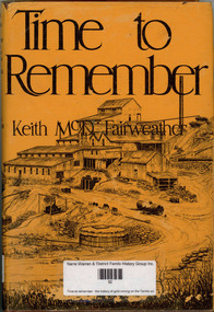
Book, Keith McDonald Fairweather, Time to remember : the history of gold mining on the Tambo and its tributaries, 1975
Contains stories of old mines in the area in great detailnon-fictionContains stories of old mines in the area in great detailtambo river valley, cassilis gold mining co, gold mines, shire of omeo -
Lakes Entrance Historical Society
Administrative Record - Tambo Historical Society Documents, Tambo Historical Society, 1977
Various receipts, receipt books, cheque stubs, banks books etcBlack box file containiong various documentation related to Tambo Historical Society, box has lid hinged on left hand side, black and sliver stipled, inside of box is mounted steel sprung clip. Tambo Cat No 459documents, commercial -
 Federation University Historical Collection
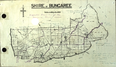
Plan, Shire of Bungaree
The former Shire of Bungaree is now part of Moorabool Shire.Plan of the Shire of Bungaree. Scale is 1 inch to 1 mile with the total distance approximately 40 miles. Includes Gong Gong Reservoir, Kirks Reservoir, White Swan Reservoir, Wilson's Reservois and Moorabool Reservoir. Purple line in purple pencil indictaes suggested scenic tour of the Bungaree Shirebungaree, water supply, barkstead, humffray street, ballarat, doveton (north) stret, ballarat, ballarat water commission, great dividing range, wombat state forest, mineral water springs, gong gon reservoir, kirks reservoir -
 Federation University Historical Collection
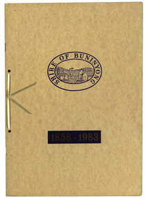
Book, Waller & Chester Printers, Shire of Buninyong 1858-1983, 1983
Documents special meeting of Buninyong Shire Council held on 30 August 1983 to commemorate the 125th anniversary of the first meeting of the Buninyong District Road Board.. Includes images of four generations of Archibald Fisken, photographic copy of Victoria Government Gazette proclamations of the Buninyong Road District, details of inaugural meeting and minutes of the first and second meetings, members of council 1983, a list of Chairmen, Mayors and Presidents and extracts from past records.Beige soft covered book 14 pages with images of four Archibald Fisken, KW McManus and other details related to the 100 years of the Bininyong Shire Council. Ink on paper.Shire of Buninyong 1858-1983buninyong shire council, buninyong road district, archibald fisken, local government -
![Country Victoria's Own: 150-year history of the 8th/7th Battalion Royal Victoria Regiment and its predecessors 1858-2008 / [by] Neil Leckie](/media/collectors/550653872162f11fb04854aa/items/5ece6383f36c2704c4f2b206/item-media/5ece6469f36c2704c4f2b332/item-fit-380x285.jpg) Kew Historical Society Inc
Kew Historical Society IncBook, Australian Military History Publications, Country Victoria's Own: 150-year history of the 8th/7th Battalion Royal Victoria Regiment and its predecessors 1858-2008, 2008
History of the 8th/7th Battalion and its predecessors 1858-2008Loftus, N.S.W. : Australian Military History Publications, 2008 xxi, 352 p. : ill., ports. ; 26 cm. History of the 8th/7th Battalion and its predecessors 1858-2008victoria -- armed forces -- history., victoria -- history, australia. army. royal victoria regiment. battalion 8th/7th -- history. -
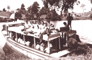 Lakes Entrance Historical Society
Photograph, Peels launch Zephyr on Tambo River near bridge at Swan Reach Victoria, 1940 c
Black and white photograph of Peels launch Zephyr filled with passengers moored at landing place on Tambo River near bridge at Swan Reach Victoria. Also a second black and white photograph of Peels launch Zephyr in Tambo River with Swan Reach bridge in backgroundboats and boating, tourism, rivers -
 Phillip Island and District Historical Society Inc.
DVD, Brief History of Rhyll, May 2017
Jakeb Anhyu was the artist in residence. Lorna Collins and Eileen Maiden were both McFees.Contains interviews with several local identitiesDVD Runs for approx. 10 mins. Filmed as part of the Bass Coast Shire Council ‘Artists in residence’ Program. Features several local identities and historical buildings discussing local history.A Brief History of Rhyll by Jakeb Anhyumcfee family, lorna collins, eileen maiden, john jansson, rhyll post office, frank jansson, jim mcfee, chicory kiln, piadhs museum, dvd, rhyll history, marine history rhyll, mangroves at rhyll -
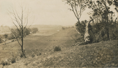 Lakes Entrance Historical Society
Photograph - river flats at Tambo Upper near Bruthen Victoria, 1925
Sepia toned photograph of river flats at Tambo Upper with maize crops in distance, glimpse of Bruthen VictoriaJanuary 1925 Honeymoon trip on backagriculture -
Tatura Irrigation & Wartime Camps Museum
Book, Tatura, 1969
History of the Shire of RodneyHardback. Dust cover inscription of title, with a colour print of tomatoes underneath.Tatura & The Shire of Rodney