Showing 4374 items
matching the avenue
-
 Whitehorse Historical Society Inc.
Document, Certificate of Title - William McConville, 1903, 1929
Certificate of Title in the name of William McConvilleCertificate of Title in the name of William McConville re Lots 44 and 45 on the corner of Victoria Avenue and Albert Streets, Mitcham. Includes details of mortgage registered 16 Jul 1929.Certificate of Title in the name of William McConvillemcconville, william, land titles, shire of blackburn and mitcham, victoria avenue, mitcham, albert street, mitcham -
 Kew Historical Society Inc
Plan - Subdivision Plan, Kew Golf Links Estate, 1936, 1936
The Kew Golf Links Estate was a major subdivision in North Kew. It derived its title due to the land being previously occupied by the Kew Golf Club, which transferred its course to a number of locations before occupying its current site. The Plan advertises 180 choice home sites. The street names are somewhat different today as those on the map are named after the proposed Kodak Factory to be built on the site. The subdivision of the Kew Golf Links Estate was a major subdivision of farmland in Kew. The site was at one stage designated for industrial development and the building of a new Kodak factory. The decision by Council to oppose the redevelopment makes the beginning of the period when all industrial development was banned in Kew.Monochrome printed, folded subdivision plan for the Kew Golf Links Estate, to be auctioned on 7 November 1936. Streets named include: Carnegie Avenue, Willsmere Road, Kilby Boulevarde, Kodak Avenue, Coleman Avenue, Beresford Avenue, McConchie Avenue, Cole Avenue, White Avenue, Baker Avenue, Spruzen Avenue, Tanner Avenue, Ratten Avenue, Mathers Avenue, Railway Avenue, Sutherland Avenue, and Belford Road. The position of the Yarra River and a large Drainage Reserve are marked on the plan. Lots for sale are numbered. Existing buildings are designated with a square.subdivision plans - kew (vic), kodak factory - kew (vic) -
 St Kilda Historical Society
Photograph, Ascog, Southey St, Elwood, c.1872
Ascog Southie St. Residence in 1872 of Gavin Gibson, Merchant. Demolished. Land subdivided and now inclues Avoca Avenue and courtblack and white photograph, unmounted, copy, good conditionOn back: Ascog Southie St. Residence in 1872 of Gavin Gibson Merchant. Demolished and land subdivided and now inclues Avoca Avenue and court -
 Phillip Island and District Historical Society Inc.
Photograph, Thompson Avenue, Cowes Phillip Island, 1920
This is from Jessie Smith's collection presented by Stan McFee. The vessel is HMS Australia. Avenue shows young Cypress trees planted in 1912 approx.Black & White Photograph of Thompson Avenue, looking north across Western Port Bay. Silhouetted ship in middle. Young Cypress in middle with lamp-post and pole at extreme right.HMS Australia 1920 Coweslocal history, photographs, mains street - streetscape - cowes, phillip island, black & white photograph, jessie smith, main street cowes 1920, stan mcfee -
 St Kilda Historical Society
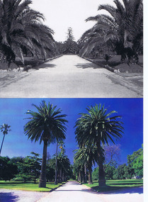
Photograph, St Kilda Botanical Gardens, c. 1950 and c. 1995
Palm avenue at Blessington Street entrance, c. 1950 and 1995colour and black and white postcard (3 post cards - identical)Palm Avenue at Blessington Street entrance. Historic gardens in the City of Port Phillip postcard series celebrating the launch of the Royal Botanic Gardens Melbourne. Flora for Victoria 1996. -
 Ringwood and District Historical Society
Document - Subdivision Map, Part of Crown Sections 18, 19, 24 & 25, Parish of Warrandyte, County of Evelyn, Vol 5228 Fol 472 - 1926. (Park Orchards, Victoria)
A3 and A4 sized photocopies showing map section of land title showing streets, easements and allotment numbers, some with handwritten names and pricing notations circa mid 1950s.Map includes Valley Road, Granard Avenue, Park Road, Arundel Avenue, Hylton Avenue, Aviemore Avenue, Bowmore Avenue, Hopetoun Road, Colin Avenue, Daintree Avenue, Brucedale Crescent, Feversham Avenue, Ennismore Crescent, Iona Grove, Elgin Crescent and Gosford Crescent, Park Orchards, Victoria. -
 Melbourne Tram Museum
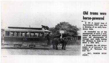
Photograph - Black & White Photograph/s, mid 1970's
Black and white photograph the Australasian Post magazine item titled "Old trams were horse-powered" of Melbourne Zoo horse tram No. 43 in The Avenue at Royal Parade, Parkville. See item 8356 for a similar photo with the same tramcar.In ink on rear "Melbourne Zoo horse tram No. 43 in The Avenue at Royal Parade, Parkville, plus text. From a periodical in the R. W Green collection".trams, tramways, horse trams, zoo tram, royal park, tram 43 -
 City of Kingston
Pamphlet - Colour, T. H. Ould Publishing Co, The Ridge Estate, Cheltenham, c. 1930
Sales plan for land in the suburb of Cheltenham, bounded by Johnston Street, Silver Street and Cavanagh Street, incorporating lots on either side of Sunray Avenue.The developing urban area of Cheltenham within the City of Kingston. This land sale pamphlet illustrates the subdivision of land within the municipality and the changing demographic of the district as new houses are constructed close to infrastructure.Colour pamphlet advertising for sale lots in The Ridge Entrance Estate, Cheltenham. Incorporates a map of the estate bordered by Johnston Street, Silver Street and Cavanagh Street, including subdivision lots on either side of Sunray Avenueland sales, estate, cheltenham -
 Glen Eira Historical Society
Album - Album page, Lynedoch Avenue, Circa 1972
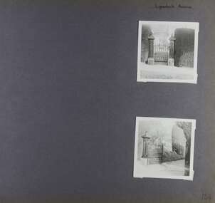
This photograph is part of the Caulfield Historical Album 1972. This album was created in approximately 1972 as part of a project by the Caulfield Historical Society to assist in identifying buildings worthy of preservation. The album is related to a Survey the Caulfield Historical Society developed in collaboration with the National Trust of Australia (Victoria) and Caulfield City Council to identify historic buildings within the City of Caulfield that warranted the protection of a National Trust Classification. Principal photographer thought to be Trevor Hart, member of Caulfield Historical Society. Most photographs were taken between 1966-1972 with a small number of photographs being older and from unknown sources. All photographs are black and white except where stated, with 386 photographs over 198 pages. National Trust - 9 Lynedoch Avenue, CAULFIELD NORTH VIC 3161 - Property No B3310 https://vhd.heritagecouncil.vic.gov.au/places/65663 - this record is just one photo with no text; the photo is almost identical to the photograph of the smaller gate on this album page. Page 124 of Photograph Album with two square photographs of gates.Handwritten: Lynedoch Avenue [top right] / 124 [bottom right]trevor hart, gates, cast iron gate, caulfield north, gate, hedge, cast iron spears, stone plinths, masonry column, masonry pillar, lynedoch avenue, st kilda east -
 City of Kingston
Photograph - Black and white, c. 1958
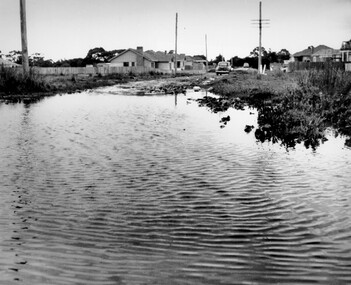
This photograph depicts flooding of Ozone Avenue in Beaumaris, located off Balcombe Road. Roads in the Beaumaris area lacked sufficient drains to clear surface water. In many cases streets were unsealed and without footpaths and some were dirt tracks. Gutters and road surfaces were made of clay and in the wetter months of winter, unsealed roads and tracks became impossible quagmires that were unnavigable for vehicles and pedestrians. In the first decade after World War II there was rapid expansion in construction of new houses in the suburb of Beaumaris. Utilities and infrastructure to support the growth of housing was inadequate and not provided for prior to the development of the area. Without rudimentary drainage, flooding was frequent. Storm water runoff, domestic sullage and septic tank overflow would form large pools and families were sometimes marooned within their homes. The frequent flooding caused isolation and hardship and residents endured difficulties with accessibility to facilities. These disadvantages had the potential to cause social issues for the new residents.Black and white photograph of flooding in Ozone Avenue, Beaumaris. The image shows floodwaters with boggy and rough terrain on an unsealed road with housing in the distance.Handwritten in blue ink: 2124 circled Handwritten in red ink: 80% Handwritten in blue ink on yellow Post-It note: Chap 6. underlined, 2194 Ozone Ave Beaumaris 1958beaumaris, ozone avenue, balcombe road, flooding, roads, infrastructure -
 Mt Dandenong & District Historical Society Inc.
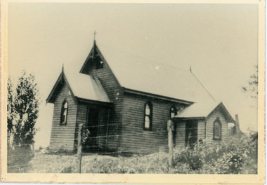
Photograph, Church of England, Olinda
Church of England. Monash Avenue, Olinda. The descriptive text on the reverse of this photograph was hand written by John Lundy-Clarke.Church of England Olinda When the church was built it faced on to the main Mt Dandenong Road but the road was deviated in and the main road section in front of the Village Settlement blocks was named Monash Avenue. The chapel built on Mrs Warner’s land on Mernda Road (later Coonara Road) was shifted in 1936 by Dick Mitlan using Jack Clarkes Ford truck as traction plant. church of england, olinda, monash avenue -
Ringwood and District Historical Society
Report, Ringwood Bypass and Suda-Larissa Avenue pedestrian crossing reports. 1992, 14-Jul-92
Brief notes and a locality map issued to local householders about a meeting to discuss the Suda-Larissa Avenue pedestrian crossing.Brief notes and a locality map issued to local householders about a meeting to discuss the Suda-Larissa Avenue pedestrian crossing. Report comprising three white A4 pages: two with typed notes and one of Ringwood Bypass notes. +Additional Keywords: Adams, Chris -
 Lakes Entrance Historical Society
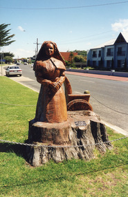
Photograph - WW1 Memorial avenue cypresses tree carvings by John Brady, 1999
most westerly chain saw carving made from trunk of WW1 Memorial avenue cypresses. On lawn verge, south of Princes Highway, opposite Bellevue, Lakes Entrance Victoria Carved by chainsaw artist John Brady August 1998.Colour photograph of the most westerly chain saw carving made from trunk of WW1 Memorial avenue cypresses. On lawn verge, south of Princes Highway, opposite Bellevue, Lakes Entrance Victoriaworld war 1914-1918, memorials -
 Sunbury Family History and Heritage Society Inc.
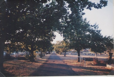
Photograph, Lydia Kenworth, Sunbury Cemetery, March 2001
The avenue of trees is along the main pathway of the old section of the Sunbury Cemetery. In 1862 the cemetery in Sunbury was laid out in Christian denominational sections. There were other sections set aside for paupers, heathens and pagans. Over the years the size of the cemetery has increased to keep pace with the growth of Sunbury's population.Sunbury Cemetery is one of the oldest cemeteries in the local area.A non-digital coloured photograph of an avenue of trees in a cemetery. The photograph is one of a collection of images that was entered in a photograph competition organised by the former Sunbury & District Heritage Association in March 2001.cemeteries, sunbury, sunbury cemetery -
 City of Ballarat
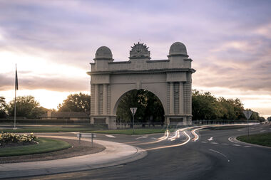
Public Artwork, Arch of Victory Monument, 1920
A grand cement rendered masonry structure of a single central arch flanked by wide piers 20metres in width, spanning the roadway, and 18 metres high. Crowned by the 'Rising Sun' symbol of the Australian Commonwealth Military Forces beneath which the words Avenue of Honour and Victory are written prominently across the arch. Erected in 1920, the Arch marks the beginning of s 22 kilometre stretch of 3728 trees, each one a memorial to men and women in order of enlistment for World War 1. On 2 June 1920, the Prince of Wales opened the Arch and was presented with a pair of silk pyjamas embroidered with Australian emblems. Each of the 500 'Lucas Girls' had put in a stich. The Arch of Victory, located at the entrance to the Avenue of Honour Ballarat, was erected in 1920 as a memorial to the people of the Ballarat and the surrounding district who enlisted in World War I. The Avenue of Honour, with the Arch of Victory, was officially opened by the Prince of Wales on 3rd June 1920. The single central arch is flanked by wide piers 20 metres in width, spanning the roadway, and 18metres high. The monument is of historical significance to the people of BallaratCement rendered masonry arch structureCrowned by the 'Rising Sun' symbol of the Australian Commonwealth Military Forces beneath which the words Avenue of Honour and Victory are written prominently across the arch.arch of victory, avenue of honour ballarat, australian commonwealth military forces, world war i, prince of wales, lucas girls -
 City of Kingston
Pamphlet - Colour, Farrow Falcon Press, Printers, Ozone Estate, Bluff Road, Hampton, c.1940
Sales plan for land in the suburb of Hampton (Highett), bounded by Bluff Road, Wickham Road, Peterson Street and June Street. Includes Morley Street, Follett Avenue, and Parrett StreetThe developing urban area of Highett within the City of Kingston. This land sale pamphlet illustrates the subdivision of land within the municipality and the changing demographic of the district as new houses are constructed close to infrastructure.Colour pamphlet advertising for private sale the Ozone Estate, Bluff Road Hampton. Incorporates a map of the estate bordered by Bluff Road, Wickham Road, June Street and Peterson Street including Morley Street, Follett Avenue and Parrett Street.Handwritten in grey pencil on reverse: Ozone Printed in purple ink on front top right-hand corner: Vendors are - Leslie Harcourt MacGowan, Esq / Neerim Road, Caulfield / & / Arthur Alfred Parrett, Esq / 311 Flinders Lane / Melbourneland sales, estate, hampton, highett -
 City of Kingston
Pamphlet - Colour, Farrow Falcon Press, Printers, Ozone Estate, Bluff Road, Hampton, c. 1940
Sales plan for land in the suburb of Hampton (Highett), bounded by Bluff Road, Wickham Road, Peterson Street and June Street. Includes Morley Street, Follett Avenue, and Parrett StreetThe developing urban area of Highett within the City of Kingston. This land sale pamphlet illustrates the subdivision of land within the municipality and the changing demographic of the district as new houses are constructed close to infrastructure.Colour pamphlet advertising for private sale the Ozone Estate, Bluff Road Hampton. Incorporates a map of the estate bordered by Bluff Road, Wickham Road, June Street and Peterson Street including Morley Street, Follett Avenue and Parrett Street.Handwritten in grey pencil on rear: Ozone Estateland sales, estate, highett, hampton -
 Ringwood and District Historical Society
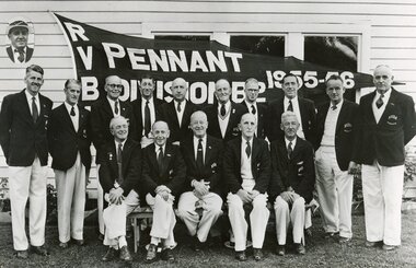
Photograph - Group of Ringwood bowlers, outside the club house in Miles Avenue, celebrating the success in winning Division B2 pennant in the 1955-56 season, Ringwood Bowls Club
... Avenue, celebrating the success in winning Division B2 pennant in ...Black and white photographTeam members Back Row L to R: D.B.Anderson, A.Ellis, J.Sharpley, H.Brown, W.Kane, G.Aird, R.Anderson, W.Daniels, R.Robinson, G.Gordon. Front Row L to R: C.Richmond, W.Wademan, D.A.Dale, W.Hancock, S.Hunt. Inset: W.Gillespie. -
 Ballarat RSL Sub-Branch Inc.
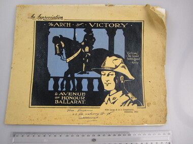
Publication - "An Appreciation The Arch of Victory & Avenue of Honour Ballarat"
... Publication - "An Appreciation The Arch of Victory ..."With Lucas & Co.'s Compliments Christmas, 1921" Name written on front = Vera Andrew 28 Armstrong Street South, Ballaarat"first world war (ww1), 1914 - 1918, literature, ballarat rsl, ballarat -
 Kew Historical Society Inc
Photograph - Photographs, Former Baptist Church, Woodlands Avenue, Kew East, 2018, 2018
The former Baptist Church, at 8-12 Woodlands Avenue, Kew East, was nominated by the Society for protection as part of the Kew East Heritage Gap Study. W D Vaughan in his 'Kew's Civic History' (1960 writes that: "With the development of East Kew, local Baptists considered the establishment of a church was necessary. A block of land was purchased in Woodlands Avenue and the foundation stone of a new church was laid on August 8, 1931. A fine Sunday school has since been erected, and special emphasis has been given to providing activities for the young people of the church"Three colour photographs of the former Baptist Church in Woodlands Avenue, Kew East. The photographs are of the front and side of the clinker brick building. One of the photographs shows the foundation stone, laid by AH Lewis Esq, 8 August 1931.churches - kew (vic), baptist church - woodlands avenue - kew (vic) -
 Lakes Entrance Historical Society
Photograph - Memorial trees Lakes Entrance, 1999
John B Carpenter left 100 pounds in his Will to enable the Tambo Shire Council to plant this avenue in memory of John Carpenter, see Item 18 in Tambo Shire Council Minutes, 15 August 1967.Colour photograph of the avenue of Queensland Box trees, Tristiana conferta, in Roadknight Street, planted as a memorial to John Carpenter, early settler of Gippsland and main contractor of the building of the man made entrance through to the sea. Lakes Entrance Victoriamemorials, local history -
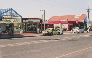 Lakes Entrance Historical Society
Photograph - Post Office and Centre Point Arcade Lakes Entrance Victoria c2006, M Holding, 2006
the corner of Esplanade and Barkes Avenue with the Post Office on the Eastern corner and Centre Point Arcade on the Western corner taken when the main arcade shop was occupied by camping and Leisure business Lakes Entrance VictoriaColour photograph showing the corner of Esplanade and Barkes Avenue with the Post Office on the Eastern corner and Centre Point Arcade on the Western corner taken when the main arcade shop was occupied by camping and Leisure business Lakes Entrance Victoria c2006 accommodation, postal services, roads and streets, businesses -
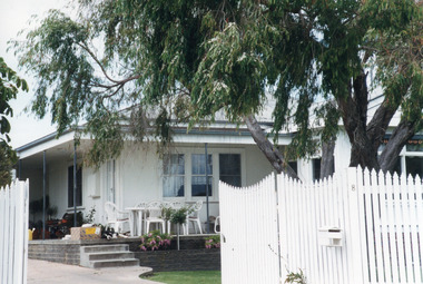 Lakes Entrance Historical Society
Photograph - Historic House, 2000
Building was lounge and ballroom for Robin Hood Inn, a popular guest house situated on corner of Esplanade and Carstairs Avenue. It was broken up, and components relocated, to make way for Sherwood Lodge Motel in 1958.Colour photograph of a fibro dwelling, hipped roof with gable extension, veranda over main room with triple sash window and French door. White timber picket fence and gate, situated at 8 North Arm Avenue, Lakes Entrance Victoriahouses, heritage study -
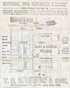 Whitehorse Historical Society Inc.
Document, Kings Padddock Blackburn
... the avenue ...Plan showing land for sale at Kings PaddockPlan showing land for sale at Kings Paddock, Blackburn (second section).Plan showing land for sale at Kings Paddockauctions, kings paddock, blackburn, south parade, laburnum street, the avenue, fuchsia street, laurel grove, main street, t.r.b. morton & son -
Whitehorse Historical Society Inc.
Map, Plan, 1939
... The Avenue ...Plan of subdivision, part of crown portion 83A and 83, Parish of Nunawading, County of BourkePlan of subdivision, part of crown portion 83A and 83, Parish of Nunawading, County of BourkePlan of subdivision, part of crown portion 83A and 83, Parish of Nunawading, County of Bourkestreet names, parish of nunawading, station street, blackburn, railway road, blackburn, vine street, blackburn, south parade, blackburn, laburnum street, blackburn, main street, blackburn, gardenia street, blackburn, the avenue, blackburn, fuschia street, blackburn, linum street, blackburn -
Whitehorse Historical Society Inc.
Document, Certificate of Title, 1914 - 1928, 1933
... The Avenue ...Certificate of Title.Certificate of Title, Frank Wesley Day. Lot 14 Subdiv. 6280 Crown portion 84 Blackburn 1928. Certificate of Title. Frank Wesley day Lots 15,22 & 23 as above. Vol 3817 fol 763269 1914. Certificate of Title. Frank Wesley Day Lot 21 as above. Vol 4259 fol 851779. Certificate of Title Charles Morgan Rosser Vol 5262 Fol 1052323. 1927 Certificate of Title. Beatrice May Ward Oakley. Lot 17 Subdiv 6280 Portion 84 Vol 4132 fol 826293. 1918 Certificate of Title, Beatrice May Ferguson, Lots 18, 19 & 20 Subdiv 6280 Vol 3856, fol 771029. 1914. Also correspondence re enforcement of charge 1933.Certificate of Title.land titles, shire of nunawading, shire of blackburn and mitcham, day, frank wesley, rosser, charles morgan, oakley, beatrice may ward, ferguson, beatrice may, the avenue, blackburn, laurel grove, blackburn, fuschia street, blackburn -
Whitehorse Historical Society Inc.
Document, Francom's Paddock Blackburn, 1914
... the avenue ...Auction of 80 lotsAuction of 80 lots at Francom's Paddock, BlackburnAuction of 80 lotst. r. b morton & son, francoms paddock, blackburn road, blackburn, canterbury road, south parade, main street, myrtle grove, laurel grove, laburnum street, the avenue, fuchsia street, view street, linum street, kings paddock, blackburn township estate, gardenia street -
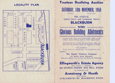 Whitehorse Historical Society Inc.
Document, Realising Auction, C1956
... the avenue ...Trustee Realising AuctionTrustee Realising Auction 18/11/1956Trustee Realising Auction equity trustees company, ellingworth estate agency, armstrong & hoath, estate agents, corr & corr, solicitors, laburnum street, blackburn, the avenue, laurel grove -
 Whitehorse Historical Society Inc.
Document - Leaflet, Blackburn Land Sale, 19/11/1910 12:00:00 AM
... the avenue blackburn ...Pamphlets showing sale of land Gardenia Street, Blackburn and surrounding streets.Pamphlets showing sale of land Gardenia Street, Blackburn and surrounding streets. Schedule of prices. Hand drawn mapPamphlets showing sale of land Gardenia Street, Blackburn and surrounding streets.blackburn township estate co. ltd., blackburn railway station, south parade blackburn, laburnum street, blackburn, the avenue blackburn, fuschia street blackburn, linum street blackburn, main street, t.r.b.morton. & son, land subdivision -
Whitehorse Historical Society Inc.
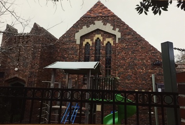
Article, Anglicans help Blackburn Catholics with 25th Anniversary, 1979
... The Avenue Uniting Church ...Article about St Thomas the Apostle Roman Catholic Church in BlackburnArticle about St Thomas the Apostle Roman Catholic Church in Blackburn celebrating their 25th anniversary and asked their neighbouring Anglican church to conduct the service.Article about St Thomas the Apostle Roman Catholic Church in Blackburn st johns anglican church, blackburn, williams, john, dr, st thomas the apostle catholic church, blackburn, perkins, eric, bp, the avenue uniting church, blackburn