Showing 174 items
matching tourism maps
-
 Lakes Entrance Historical Society
Book, Regional Coordination Group and Strategy Steering Committee, The East Gippsland Planning and Development Strategy, 1997
An outline of planning and proposed development by the East Gippsland, Victoria, Shire Council from 1997 to the year 2010. Maps included.township, land settlement, tourism -
 Warrnambool and District Historical Society Inc.
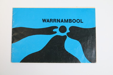
Booklet - Tourist booklet, Warrnambool Chamber of Commerce and Industry, Warrnambool, c. 1970
Warrnambool Tourist BookletThis is a booklet of 30 pages with a blue and black cover featuring an art work, a map, advertisements, black and white photographs and printed text. The booklet was stapled but the staples have been removed.non-fictionWarrnambool Tourist Bookletwarrnambool tourism, warrnambool tourist guides, warrnambool chamber of commerc -
 Warrnambool and District Historical Society Inc.
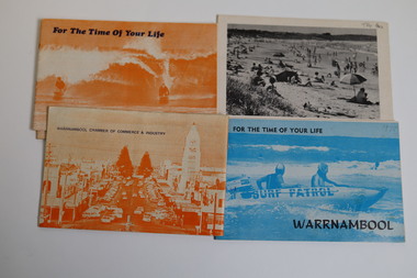
Booklet - Warrnambool Tourist Guides (5), Warrnambool Chamber of Commerce and Industry, Warrnambool - For the Time of Your Life, 1970-1975
Warrnambool Tourist Guides 1970-1975.1,.2,.3 - These are booklets of 36 pages with an orange cover with an illustration of two people on surf boards on the front cover and an image of a main street on the back cover. The cover has blue printing. The pages contain a map, advertisements, black and white photographs and printed text. One booklet is stapled and two have the staples removed. .4,.5 -These are booklets of 40 pages with a front cover with a photograph in blue tones of a surf patrol boat and two lifesavers and a back cover with a black and white photograph (beach scene). The pages contain a map, advertisements, black and white photographs and printed text. One booklet is stapled and one has the staples removed. non-fictionWarrnambool Tourist Guides 1970-1975warrnambool tourism, tourism in warrnambool in the 1970s -
 Warrnambool and District Historical Society Inc.
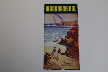
Pamphlet - Tourist Map and Guide, Victorian Railway Commissioners, Warrnambool Victoria Australia, c. 1950
Warrnambool Tourist Map and Guide.1 This is a single sheet of paper folded twice to make a pamphlet. It has a multi-coloured map (predominantly yellow), an illustration, several black and white photographs, printed text and coloured headings. .2 This is a single sheet of paper inserted into item 1. It is folded twice and contains black and white photographs.non-fictionWarrnambool Tourist Map and Guidetourism in warrnambool, warrnambool rail, warrnambool tourist guides -
 Warrnambool and District Historical Society Inc.
Pamphlet (Collection) - Warrnambool Tourist Maps, Warrnambool City Council, 1975 to 2002
Warrnambool Tourist Maps collected over the years by Warrnambool Historical Society membersPreservation of local maps for historical purposesEnclosed in A4 size plastic envelopes in an A4 size archival box and numbered and catalogued according to the date of acquisition.This collection has 16 pamphlets containing maps of Warrnambool and district and some accompanying printed materialwarrnambool tourism, city of warrnambool, shipwreck coast tourismwarrnambool tourism, city of warrnambool, shipwreck coast tourism -
 Ballarat Tramway Museum
Document - Letter/s, Dave Macartney, Nov. 1970
Yields information in the form of a letter from an active tram enthusiast at the time recommending that part of the Ballarat system be retained for heritage tramway operation by the TMSV.Two typed A4 size sheets, photocopied, undated, early 1971 written by Dave Macartney of Albert Park to a number of people recommending that the TMSV establish a tramway museum in Ballarat around the shores of Lake Wendouree. Includes a map showing a possible track layout. Gives supporting cases, issues, problems, notes tourism potential, street running and other matters. Has been hand address to "Graeme". Dave Macartney advised 6/10/2007 that written November 1970, 50 copies made."Graeme" in blue ink.trams, tramways, ballarat, preservation, tmsv -
 Melbourne Tram Museum
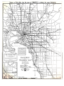
Map, Gawler and Drummond Architects, "Railway and Tramway Map of Melbourne and Suburbs", 1920's?
... Tourism Map - photocopy - titled "Railway and Tramway Map ...Map - photocopy - titled "Railway and Tramway Map of Melbourne and Suburbs", c1920 showing railways, cable, electric tramways and authorised electric additions. Shows the South Melbourne St Kilda tram line and some lines in the Footscray area as dotted. Prepared by Gawler and Drummond Architects. Has an advertisement for "Rolfes" tea along the top edge and "See Victoria First" - Government Tourist Office, corner of Swanston and Collins St.trams, tramways, map, footscray, st kilda, new tramway, melbourne, tourism -
 Melbourne Tram Museum
Pamphlet, Yarra Trams, "City Circle Tram Melbourne", 2003
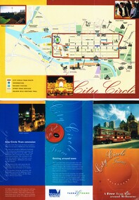
Pamphlet - DL 6 fold from A3 sheet, full colour titled "City Circle Tram Melbourne", detailing the City Circle tram, c2003 - has route via Harbour Esplanade - map shows various points, the Golden Mile heritage walk. Notes that the route had recently been extended to run through Docklands. Has contact details but no web site. Has the Victoria government and Yarra Trams logos. Tram was extended early 2003. See Reg Item 866, 2703 and 2993 for other versions. Set of five additional pamphlets, all DL when folded about the Circle Tram - variants on a theme. All with a map. .1 - 6 fold - PTC - 1994 - could be the first pamphlet - has logos of State Govt, Agenda 21, Better Cities and PTC. .2 - 8 fold - Yarra Trams and Vic Govt - details the points of interest and general tram travel. .3 - 8 fold - 2009 - Yarra Trams, Vic tourism, city of Melbourne - as above. Running via Spencer St .4 - single DL sheet - 2009 update - extended service - to Docklands, with map .5 - single DL sheet - 2/2012 - simple details.trams, tramways, city circle, yarra trams, docklands, spencer st -
 Melbourne Tram Museum
Newspaper, The Age, The Port Phillip - Caulfield Leader, "Hailing a tram by the Bayside", "Trams off track", "Tram ride by the seaside? Rattling good vistas guaranteed", 18/10/2004 12:00:00 AM
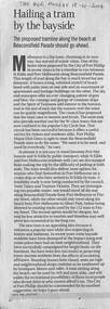
Newspaper clipping - set of three items about the possibility of a tram running along Beaconsfield Parade between St Kilda and Port Melbourne. .1 - Editorial from The Age, 18-10-2004, titled "Hailing a tram by the Bayside" supporting the proposal by The Mayor Dick Gross. .2 - item from The Port Phillip - Caulfield Leader of 5/6/2007, with the title "Trams off track", about the City of Port Phillip on the proposal, though $70000 had been spent on the study. Quotes Paul Smith of the City about the proposal, tourism only, not a public transport link. Has an image of the Port Phillip Leader of 12/12/2006 announcing the proposal. Item written by Peter Rolfe. .3 - item from The Age, 14/10/2004 titled Tram ride by the seaside? Rattling good vistas guaranteed", fearing a photo of the bay, maps and options to use Mills St. Item written by Dan Silkstone.trams, tramways, new tramway, beaconsfield parade, port melbourne, st kilda, city of port phillip, mills st -
 Melbourne Tram Museum
Pamphlet, J B Publications, "Visitors Guide to Melbourne", May. 1974
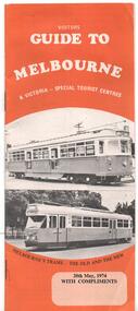
Pamphlet - 28 pages, centre stapled titled "Visitors Guide to Melbourne", dated 20 May 1974. Has on front cover trams W7 1032 and PCC 1041 with the caption "Melbourne's Trams - the old and the new" Has many advertisements, a small map, places of interest including Sovereign Hill, Leonda, driving in central Melbourne and wearing of seat belts. Has photo looking north along Swanston St - see image 2. Welcome by Minister for Tourism Murray Byrne.trams, tramways, melbourne, visitors, guides, w7 class, 1041, tram 1032, tram 1041 -
 Melbourne Tram Museum
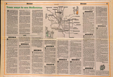
Newspaper, The Age, "Tram ways to see Melbourne", 8/5/1981
Newspaper clipping, from The Age, Weekender, Friday 8/5/1981 titled "Tram ways to see Melbourne", with a number of writers giving a short piece on a particular line. Has a Map of the Melbourne system with destination and route numbers. Has an introduction written by Phillipa Hawker which looks at the history, its place in Melbourne, and possibilities for the future. Written just before the MTA came into existence. Items: East Malvern, Route 3, Rebecca Batties West Preston Route 10, Phillipa Hawker St Kilda, Route 12, Frank Prain North Balwyn, route 48, Andrew Bolt West Maribyrnong route 57, Rosslyn Beeby Essendon Airport, Route 59, Rosslyn Beeby Carnegie, Route 67, Andrew Bolt Kew Cotham Rd, route 69, Andrew Bolt Wattle Park, route 70, Rosslyn Beeby East Burwood, route 75, Rosslyn Beeby East Preston, route 88, Deborah Forster Has some sketches of trams and people.trams, tramways, melbourne, people and places, tourism, east malvern, west preston, st kilda, north balwyn, west maribyrnong, essendon airport, carnegie, kew- cotham rd, wattle park, east burwood, east preston, route 3, route 10, route 12, route 48, route 57, route 59, route 67, route 69, route 70, route 75, route 88, maps -
 Melbourne Tram Museum
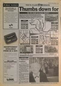
Newspaper, Herald Sun, "Thumbs down for old trams", 12/11/1993
Gives the result of a Herald Sun survey with a map - People were asked: 1 - Want to keep the W class trams 2 - Want W class for Tourism 3 - Want W class withdrawn Survey involved the Airport West, North Coburg, Mont Albert, South East (route 8 and 69, and city streets. The choice included retiring the early Z class trams, that were not even 20 years old. Includes an interview with Jean Geil by David Jarvis on the trams and with Lisa Fabian who did not like the W. Item written by Damon Johnston, Transport Reporter.Demonstrates The Herald Sun investigation into W class trams during 1993.Newspaper clipping from The Herald Sun, Friday 12/11/1993, titled partly ""Thumbs down for old trams" spread over two pages.trams, tramways, w class, surveys, public transport, state transport authority, ptc -
 Melbourne Tram Museum
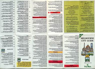
Map, The Met, "Melbourne City Guide", March 1991
Map issued by The Met, March 1991 based on a Melway map of the Central city area providing details of tram, bus and trains, attractions, major institutions, tourism information, and dining out areas or streets. Demonstrates a map produced by The Met to assist Melbourne visitors.Map - 14 fold printed on gloss paper.trams, tramways, the met, maps, melbourne, cbd -
 Melbourne Tram Museum
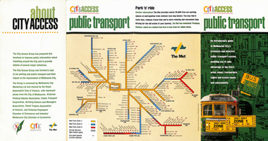
Pamphlet, The Met, "City Access Public Transport", mid 1980's
Pamphlet - four fold DL - gloss paper - titled "City Access Public Transport", providing maps and details of public transport, city circle, ticket information. Includes The Met system map and images of a W class with a destination of Football and Daily Adult Zone 1 tickets. Printed primarily for tourists. Published by The City of Melbourne, , The Met and the City Access group. Rear cover includes a list of those involved in City Access.trams, tramways, city centre, city of melbourne, public transport, tourism, tourist guides -
 Melbourne Tram Museum
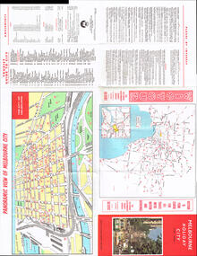
Map, Victour, "Melbourne Holiday City", c1975
Map - 12 fold special size - full colour titled "Melbourne Holiday City", published by Melbourne Tourism, c1975 prior to the construction of East Burwood tram line, providing a list of amusements, tourist locations, places of interest, map provided by Victour, The Victorian Government Tourist Bureau, a panoramic view of Melbourne and a large map of Melbourne and suburbs showing rail, bus and tram lines and key to suburbs. Cover photo with 882 (Route 11, Spencer St) in Collins St looking west with the Westgate bridge in the far background.trams, tramways, map, public transport, city of melbourne, buses, railways, tramways, victour, tram 882 -
 Melbourne Tram Museum
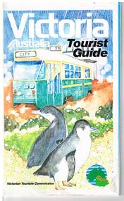
Map, Surveyor General for the Victorian Tourism Commission, "Victoria Australia Tourist Guide", 1985
... Trams tramways Victoria Map Victour Tourism Folded map ...Folded map of Victoria, showing in colour relief Victorian area, national parks, highways, towns, railways, airport, wine growing areas, towns with information centres, historic parks, ski fields. NSW and SA show major towns and highways. Front cover includes an image of a Z class tram and two penguins. Has town index. Folded 7 folds horizontally by 3 folds deep. On rear is a listing of locations with major tourist destinations provided. Provides location of VicTour offices. Prepared by the Surveyor General for the Victorian Tourism Commission, printed by the Government Printer, 4th edition 1985.trams, tramways, victoria, map, victour, tourism -
Lakes Entrance Historical Society
Book, Tourist Development Authority of Victoria, Victorias 15 National Parks, 1956
This booklet contains a description of the 15 proclaimed Victorian National Parks as at 1956. Illustrated with photographic reproductions and locality map. Historically significant because of the time period.parks, natural history, crown lands, tourism -
 City of Greater Bendigo - Civic Collection
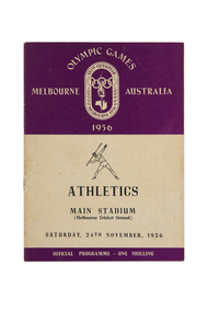
Programme, Wilke and Co Ltd, Olympic Games Melbourne Australia 1956 : Athletics, Main Stadium (Melbourne Cricket Ground), Friday, 23rd November, 1956, 1956
Held in Melbourne from the 22nd November to 8th December, the 1956 Summer Olympics, officially known as the Games of the XVI Olympiad or the Melbourne Olympics were the first held outside of Europe or the USA. The Olympic torch relay passed through Central Victoria on its way from Cairns to Melbourne. Small book containing 15 pages including map of competition venues and programme on the back cover. Front cover depicts male javelin thrower. Printed in black and purple ink.melbourne olympic games, city of greater bendigo tourism -
 City of Greater Bendigo - Civic Collection
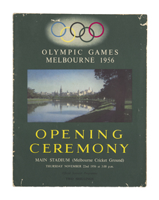
Programme, Melbourne Olympic Committee, Opening ceremony : Olympic Games, Melbourne 1956, main stadium (Melbourne Cricket Ground) : Thursday November 22nd 1956 at 3.00 p.m, 1956
Held in Melbourne from the 22nd November to 8th December, the 1956 Summer Olympics, officially known as the Games of the XVI Olympiad or the Melbourne Olympics were the first held outside of Europe or the USA. This programme is a comprehensive guide to the opening ceremony and includes names of the organising committee and general information about the history of the Games.Colour printed programme. 31 pages, 2 unnumbered pages, illustrated, with maps. Front cover photograph of the Yarra River looking towards Melbourne CBD. Olympic rings at top of page. Stapled at fold.melbourne olympic games, olympic games 1956, city of bendigo tourism -
 City of Greater Bendigo - Civic Collection
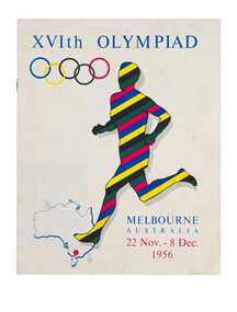
Programme - Official Olympic Souvenir, G. W. Green & Sons, XVIth Olympiad Melbourne Australia, 22 Nov.- 8 Dec. 1956, 1956
Held in Melbourne from the 22nd November to 8th December, the 1956 Summer Olympics, officially known as the Games of the XVI Olympiad or the Melbourne Olympics were the first held outside of Europe or the USA. This programme was originally enclosed with book 'Australia, Land of the Southern Cross' as is a visitors guide to Australian states and cities.Colour printed programme. 15, [1] pages. Illustrated. Colour printed front and back cover based on the Olympic ring colours. Inside pages printed in red and black. Contents include an official programme listing all the events, venues and dates; photograph and map of Olympic grounds and Village; a guide to facilities and services available to visitors during the Olympic Games and lists of Australian cities and towns with brief statistics and description for each listing. Includes an introduction by Frank Selleck, Lord Mayor of Melbourne ; Maurice A. Nathan, Chairman, Olympic Civic Committee.melbourne olympic games, olympic games 1956, city of bendigo tourism -
 Lakes Entrance Historical Society
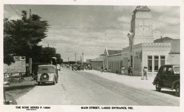
Postcard - Central Hotel Lakes Entrance, The Rose Series, 1940 c
Also another copy 01181.1Black and white postcard of the Main Street. Local map on the left hand side of scene. Spanish style Central Hotel in the right foreground. Motor cars on roadway, and pedestrians in summer clothing on paths. Lakes Entrance Victoriahotels, tourism, transport -
Lakes Entrance Historical Society
Book, Glover, Barbara, East Gippsland Victoria, 1978
A tourism information booklet depicting the rich variety and many attractions of the Gippsland Lakes, Victoria. Illustrated with colour photographs and a map of the region.waterways, township, tourism -
 Bendigo Military Museum
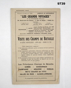
Pamphlet - FRENCH TOURISM, 1919, C.1919
Item in the collection relating to C.J.C. McQuie MM, refer Cat No 9680P for his service details.Pamphlet 16 pages, light brownish colour, all print in black, language is French, pages cover places to visit, advertising, maps and drawings, one metal staple holds all together."Les Grands Voyages"french, mcquie, pamphlet -
 Narre Warren and District Family History Group
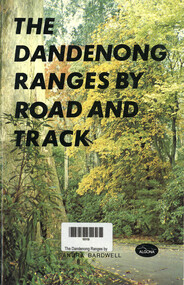
Book, Sandra Bardwell, The Dandenong Ranges by Road and Track, 1981
Tour routes in the Dandenong Ranges, including maps.64 p.; 22 cmnon-fictionTour routes in the Dandenong Ranges, including maps.dandenong ranges, tourism, cardinia reservoir, emerald lake park, aura vale lake, crystal brook park, bimbimbie wildlife park, guidebook