Showing 272 items matching "tourist map"
-
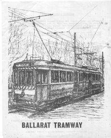
 Ballarat Tramway Museum
Document - Report, Booz-Allen Hamilton, "Final Report - Ballarat Heritage Trams - Tourism Transportation Scope & Feasibility Study", Apr. 2002
Thirty nine sheet page A4 size document, unbound, double sided report titled "Final Report - Ballarat Heritage Trams - Tourism Transportation Scope & Feasibility Study". Produced by Booz Allen Hamilton as part of the project study for the return of trams to the central part of the City of Ballarat. Dated April 2002. Contains Introduction, Role of the Tourist Tramway, Viability of the Tramway and Conclusions, with maps, financial and cost analysis, patronage estimates and comparison with other similar operations.trams, tramways, ballarat city tramway, ballarat revival, tourism, market -
 Ballarat Tramway Museum
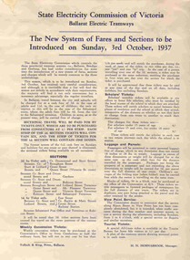
Poster, State Electricity Commission of Victoria (SECV), "The New System of Fares and Sections to be Introduced on Sunday, 3rd October 1937", Sep. 1937
Poster titled "The New System of Fares and Sections to be Introduced on Sunday, 3rd October 1937" produced by the SECV, Ballarat Electric Tramways. r. Provides information on the SEC control, the method of payment, sections, fares, weekly, school, scholars, luggage and parcel, View Point Services and Tourist Ticket. Signed by H. N. Hornabrook as Manager. Has printer's name, Tulloch and King in the bottom left-hand corner. See Reg. Item 8025 for individual copies and 8251 for the associated map/fare poster that was used in tramcars.Demonstrates the work the SEC undertook to provide information on the new ticket system of 1937 and yields information about the system.Poster contained within Reg. Item 2488, page 30, Numerous on page 31 in ink and penciltrams, tramways, sec, fares, sections, tickets -
 Ballarat Tramway Museum
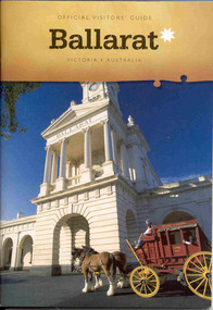
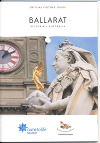
Book, The Ballarat Visitor Information Centre, "Official Visitors Guide, Ballarat, Victoria, Australia", Jul. 2006
Full colour, 84 page, book, A5 size titled "Official Visitors Guide, Ballarat, Victoria, Australia", with a Cobb and Co Coach standing in front of the Ballarat Railway station portico on the front cover. Gives details, maps accommodation listing, attractions etc of the Ballarat area. Pages 18 and 19 detail the Ballarat Tramway Museum and page 22 has the BTM advertisement. Published July 2006 by The Ballarat Visitor Information Centre.trams, tramways, ballarat, visitors, tourist guides, btm -
 Ballarat Tramway Museum
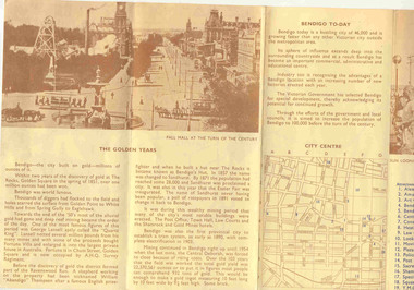
Pamphlet, The Bendigo and District Tourist Association, "Bendigo & District tourist guide", 1972
... and Bendigo today, along with a map of the important tourist features... Bendigo Trust Map Folded printed pamphlet, four folds, printing ...Folded printed pamphlet, four folds, printing in blue and brown ink on fawn paper, titled "Bendigo & District tourist guide", giving a historical outline of the district history and Bendigo today, along with a map of the important tourist features in the CBD area. On the reverse has a district map showing the location of the various district features. Published by The Bendigo and District Tourist Association in 1972. Three copies held.trams, tramways, bendigo, bendigo trust, map -
 Ballarat Tramway Museum
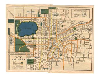
Map, Greater Ballarat Association and George Netherway, "Map of Ballarat", c1945
Yields information about Greater Ballarat, including trams, buses, locations and streets. Has a strong association with George Netherway.Five colour map of Ballarat, showing streets, places of interest, Parks, tram routes, bus routes, railway lines, prepared by G. C. Netherway, Greater Ballarat Association, for the Victorian Government Tourist Bureau, Ballarat Branch, c1945. Shows suburbs names, location of orphanage, the lack of development north of Howitt St, in Wendouree. Map is part diagrammatic and is not entirely to scale. On rear is a road map of the Ballarat area, lists of statistics, beauty spots, look outs, art and culture, points of historical interest, industrial products and recreation. Note: Image 1, assembled from four scans, does not entirely match at edges. See Reg item 2074 for photographic image of another version map. See Reg Item 5613 for another version of this map. trams, tramways, ballarat, tram routes, bus routes, map, lists -
 Ballarat Tramway Museum
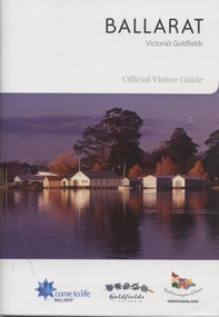
Book, The Ballarat Visitor Information Centre, "Ballarat Victoria's goldfields Official Visitor Guide", "Ballarat where Parks and Gardens come to life", 2011
.1 - Full colour, 100 page, book, A5 size titled "Ballarat Victoria's goldfields Official Visitor Guide", with an autumn view across Lake Wendouree. Gives details, maps accommodation listing, attractions etc of the Ballarat area. Pages30 and 31 detail the Ballarat Tramway Museum and the BTM advertisement on page 48. Published 2011 by The Ballarat Visitor Information Centre. .2 - Full colour 16 page brochure, titled "Ballarat where Parks and Gardens come to life" with rear fold out cover of map of the Ballarat and Buninyong district. Notes steam boats and trams on page 6.trams, tramways, ballarat, visitors, tourist guides, btm, gardens -
 Ballarat Tramway Museum
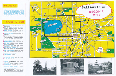
Pamphlet, Earl Ewers, "Ballaarat Begonia Festival - 1971", Sep. 2011
Yields information about the form of advertising the Ballarat Begonia Festival undertook and the relationship with Victour, the Victorian Govt. Tourist Bureau.Colour photocopy of a advertising brochure for the 1971 Ballaarat Begonia Festival - copied onto two A3 sheets. Has a map of the city showing the tram tracks, bowling greens, parks, and various locations. Gives Places to visit, programmes and Victour addresses and details. Originally published by the Ballaarat Begonia Festival Association and the Greater Ballarat Association and printed by Hedges and Bell. Three copies held. See Reg Item 2154 for the actual festival programme.trams, tramways, begonia festival, ballarat, map -
 Ballarat Tramway Museum
Book, The Ballarat Visitor Information Centre, "Official Visitors Guide, Ballarat, Victoria, Australia", 2008/09
Full colour, 84 page, book, A5 size titled "Official Visitors Guide, Ballarat, Victoria, Australia", with the upper part of the Queen Victoria statue and the Ballarat Town Hall in the background on the front cover. Gives details, maps accommodation listing, attractions etc of the Ballarat area. Pages 24 and 25 detail the Ballarat Tramway Museum and the BTM advertisement. Published 2009 by The Ballarat Visitor Information Centre.trams, tramways, ballarat, visitors, tourist guides, btm -
 Ballarat Tramway Museum
Book, The Ballarat Visitor Information Centre, "Ballarat Victoria's goldfields Official Visitor Guide", 2015
Full colour, 84 page, book, A5 size titled "Ballarat Victoria's goldfields Official Visitor Guide", with a photo of a people eating on the verandah of the hotel opposite the old post office. Gives details, maps accommodation listing, attractions etc of the Ballarat area. Page 14 detail the Ballarat Tramway Museum. Inside rear cover is a fold out map of the district, city centre, Buninyong and Mt Helen and Ballarat and Surrounds. Published 2015 by The Ballarat Visitor Information Centre. trams, tramways, ballarat, visitors, tourist guides, btm, gardens -
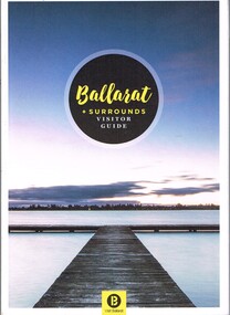 Ballarat Tramway Museum
Book, The Ballarat Visitor Information Centre, "Ballarat + Surrounds Visitor Guide", 2016
Full colour, 144 page, book, A5 size titled "Ballarat + Surrounds Visitor Guide", with a photo of Lake Wendouree. Gives details, maps accommodation listing, attractions etc of the Ballarat area. Page 30 details the Ballarat Tramway Museum. Inside rear cover is a fold out map of the district, city centre, Buninyong and Mt Helen and Ballarat and Surrounds. Published 2016 by The Ballarat Visitor Information Centre. trams, tramways, ballarat, visitors, tourist guides, btm, gardens -
 Ballarat Tramway Museum
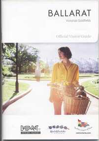
Book, The Ballarat Visitor Information Centre, "Ballarat Victoria's goldfields Official Visitor Guide", 2012
Full colour, 100 page, book, A5 size titled "Ballarat Victoria's goldfields Official Visitor Guide", with an autumn view across Lake Wendouree. Gives details, maps accommodation listing, attractions etc of the Ballarat area. Page 13 detail the Ballarat Tramway Museum and the BTM advertisement on page 23. Inside rear cover is a fold out map of the district, city centre, Ballarat and Surrounds. Published 2012 by The Ballarat Visitor Information Centre. trams, tramways, ballarat, visitors, tourist guides, btm, gardens -
 Ballarat Tramway Museum
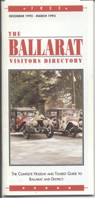
Book, Ballarat Accommodation Group for .5, "The Ballarat Visitors Directory", 1992 to 1998
Set of five visitors directory to Ballarat, or visitor guides. .1 - "The Ballarat Visitors Directory", Dec. 1992 to March 1993, 48 black and white pages + colour cover + fold out map in centre. .2 - ditto - undated, 48 black and white pages + colour cover. .3 - ditto - Summer 1995 - 1996, 40 black and white pages, including colour map in centre + colour cover .4 - ditto - Winter, but no year, 48 black and white pages + colour cover .5 - ditto - 1997 - 1998?, 76 pages full colour, + cover with fold out map. Also includes an invitation to a launch event, September 1998. Contains an BTM Advert on page 26. The dates of the above publications where undated need to be fully established.trams, tramways, ballarat, visitors, tourist guides, btm, gardens -
 Ballarat Tramway Museum
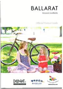
Book, The Ballarat Visitor Information Centre, "Ballarat Victoria's goldfields Official Visitor Guide", 2014
Full colour, 92 page, book, A5 size titled "Ballarat Victoria's goldfields Official Visitor Guide", with a photo of a lady and child with a bicycle behind. Gives details, maps accommodation listing, attractions etc of the Ballarat area. Page 16 detail the Ballarat Tramway Museum. Inside rear cover is a fold out map of the district, city centre, Buninyong and Mt Helen and Ballarat and Surrounds. Published 2014 by The Ballarat Visitor Information Centre. trams, tramways, ballarat, visitors, tourist guides, btm, gardens -
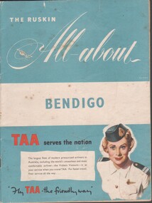 Bendigo Historical Society Inc.
Booklet - Tourist guide, 1956
The Ruskin All-About Bendigo Booklet produced for the 1956 Melbourne Olympics. Includes maps and facts, service organizations and businesses in Bendigo. Includes advertisements for Australian companies. TAA on the cover. Produced by Ruskin Publishing Pty Ltd 37 Swanston St. Melbourne.advertising, services, bendigo businesses, bendigo maps -
 Ballarat Tramway Museum
Pamphlet - advertising the Museum, Ballarat Tramway Preservation Society (BTPS), 1975
Pamphlet advertising the Museum, with a sketch of tram 40, with the name "Ballarat Tourist Tramway" on the rear and giving visiting details and fares. Has a map on the rear showing the location and track along Wendouee Parade. See item 6296 for an earlier example. Yields information about BTPS Marketing c1975.Duplicated quarto sheet two sided on white paper.tramways, ballarat, btps, map, drawings, sketches, fares, operations -
 Kew Historical Society Inc
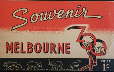
Booklet - Pictorial Souvenir of the Melbourne Zoo
Pictorial Souvenir listing Zoological Board Members, description of gardens and their history, general information, map, and profiles with photos of particular animals.Pictorial Souvenir listing Zoological Board Members, description of gardens and their history, general information, map, and profiles with photos of particular animals. Tourist booklet costing 1/-, Cover in red, black and white includes graphic design of flamingo and kangaroos. non-fictionPictorial Souvenir listing Zoological Board Members, description of gardens and their history, general information, map, and profiles with photos of particular animals. washfold family, melbourne zoo, melbourne -- tourist publications, christian-washfold collection -
 Kew Historical Society Inc
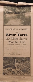
Flyer, Melbourne Ferries Pty Ltd, River Yarra: 20 Miles Scenic Wonder Trip
Bifold brochure including route map of the full 44 mile 'Wonder Trip' on pages 2 & 3. Photos used include an 'Aerial view over Dight's Falls', two ferries, and a 'Scene near Dight's Falls'.Flyer for Harding’s Launches on the River Yarra: 20 miles scenic wonder trip. Aerial view over Dight’s Falls on front. non-fictionBifold brochure including route map of the full 44 mile 'Wonder Trip' on pages 2 & 3. Photos used include an 'Aerial view over Dight's Falls', two ferries, and a 'Scene near Dight's Falls'.river yarra, melbourne ferries pty ltd, yarra river -- tourism, harding's cruises, christian-washfold collection -
Clunes Museum
Flyer - BROCHURE
... information for tourists visiting Clunes Map of Clunes Tourism ...Current information for tourists visiting ClunesColour brochure of Clunes Museum with map of Clunes on the reverseClunes Museum - Built on Goldmap of clunes, tourism brochure, clunes museum -
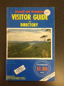 Stawell Historical Society Inc
Book, Stawell & Grampians Tourist Council, Stawell & Grampians Visitor Guide & Directory 1979, 1979
Tourist Guide to Stawell and the GrampiansBlue cover with red, yellow & blue print. Picture of the Grampians in center of cover.In Red Print Stawell and Grampians. In Yellow Print Visitor Guide and Directory. In Blue Print 4th Edition Souvenir Edition. In White Inset "Containing Offical Walking Maps. Bottom Right in Yellow Print " Issued by the Stawell and Grampians Tourist and Promotion Advisory Council. In two white circle with white and Red print the Price in Red "Recommended $1.00 Price" Bottom Right at 45 degrees in blue print Concession Coupons Inside.stawell tourism -
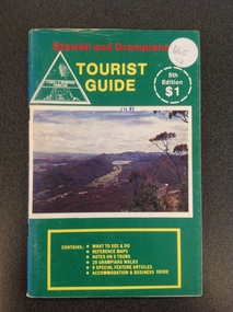 Stawell Historical Society Inc
Book, Stawell & Grampians Tourist Council, Stawell & Grampians Visitor Guide & Directory 1981, 1981
Tourist Guide to Stawell and The GrampiansGreen paper cover with Red, Yellow & White Print. Centre of page is a colour photo of the Grampians. Red Test. "Stawell and Grampians" inside white triangle "Stawell & Grampians Promotion". Yellow Print Tourist Guide" Inside a white segmented circle, white Print "5th Editon $1" Inside Yellow outlined rectangle with yellow Print. "Contains: WHAT TO SEE & DO REFERENCE MAPS NOTES ON 5 TOURS 28 GRAMPIANS WALKS 9 SPECIAL FEATURE ATICLES ACOMMODATION & BUSINESS GUIDEstawell tourism -
 Falls Creek Historical Society
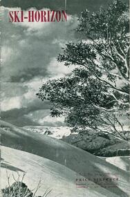
Journal - Ski-Horizon Vol. 2 No 10
Ski-Horizon is the official journal of the Federation of Victorian Ski Clubs which began publication in 1949. The were 26 original member clubs which included Albury Ski Club, Bogong Ski Club, Myrtleford Ski Club, Tallangatta and District Ski Club and Wangaratta Ski Club. Two pioneers of Falls Creek, Tom Mitchell, M.L.A., and Martin Romuld were Vice-Presidents of the Federation.This Journal is significant because it documents the early development of skiing in Victoria.The journal features stories and events chronicling developments in Victoria and internationally. Items related to the Falls Creek Area in this publication include:- Page 2: Albury Ski Club is set for a positive year. Present membership of the club is 130 and officials. recently elected are: -President, Mr. Fred Griffith; Vice-President and Booking Officer, Bob Howe; Secretary. Nell Newton; Asst. Sec., Angela Bowler; Treasurer. Sam Roxburgh; Social, Bruce Colquhoun: Trips, June Watson; Bus, Len Egan; Building. John Perger; Equipment, Peter Hadow. Page 3 Toni St. Elmo is planning the monster party the Bogong Ski Club will give at their Falls Creek Lodge on 4th August to the visiting N.Z. team. Page 8 - 9 Article - The Old Order Passes on the Bogong High Plains - an extensive response to the State Development Committee's Report "The Alpine Regions of Victoria; Skiing and Tourist Resorts" and suggestions for the construction of roads, ski tows and other facilities. A sketch map of Falls Creek Village is included.ski history victoria, federation of victorian ski clubs, development of falls creek -
 Falls Creek Historical Society
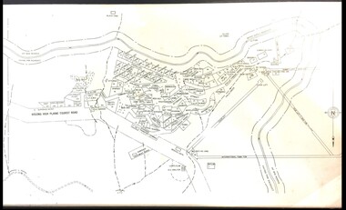
Map - Falls Creek mid 1970s
A site map produced for the Falls Creek Tourist Area Management CommitteeThis map is significant because it documents an important stage in the development of Falls Creek, Victoria.A framed and mounted site map of Falls Creek mid 1970sfalls creek tourist area management committee, falls creek tourist area, falls creek 1970s -
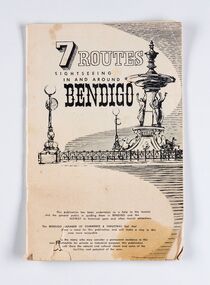 City of Greater Bendigo - Civic Collection
Booklet, J. W. H Publications, 7 Routes. Sightseeing in and around Bendigo, c 1950
A publication promoting visitation and automobile touring around Bendigo and surrounding districts. Suggests seven routes and contains extensive advertising for accommodation, businesses and services within Bendigo and Castlemaine.Thirty two page tourist fold out booklet containing maps and directions for half day and day routes in the district. Booklet also contains advertising promoting Bendigo and District businesses. city of greater bendigo commerce, city of greater bendigo tourism, making a nation exhibition -
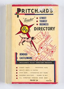 City of Greater Bendigo - Civic Collection
Book - Street Directory, A. E. Pritchard, Pritchards 'Pointer' Street - Tourist - Business - Directory, 1953
As tourism and car culture grew in the early and mid 20th century the need for street and touring directories grew. Bendigo's geographic location within central Victoria and relatively closeness to Melbourne meant that the district has long been an ideal car touring destination. A. E. Pritchard was a licensed surveyor with an office in Bull Street Bendigo and produced these handy bound directories which fit neatly into the car glovebox therefor serving both the local and state demand for high quality printed directories such as these. One hundred and thirty page printed and bound street and touring directory. Includes fold out reference and day touring maps, photographs of local 'beauty' spots and extensive advertising by local businesses. Heavy card used for front and back covers. Three colour print process.Pritchards 'Pointer' Directory Bendigo - Castlemaine.city of greater bendigo commerce, city of greater bendigo tourism, city of greater bendigo leisure, making a nation exhibition, cambridge press, mayor w cambridge -
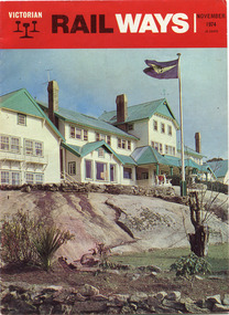 Parks Victoria - Mount Buffalo Chalet
Magazine, "Victorian Railways November 1974"
'Over the years the VR Advertising Division published a number of booklets promoting Mount Buffalo's sports and restorative powers of its scenery in summer and winter...The collection (MBCC) comprises a good range of tourist writing published as promotional booklets, guidebooks, brochures, walking trails, maps and newspaper articles.' (Pg. 119. Historica) This Victorian Railways monthly publication and also the VR Newsletter, published by the Victorian Railways Printing Works in North Melbourne, is one of a number which featured iconic photos of the Chalet of the plateau on its cover, as an identifiable flagship for The Victorian Railways and it's employees from the Railways Refreshment and Services Branch. These publications also have stories regarding upgrades and on long serving staff of the Chalet.Listed in Draft Inventory of Significant Collection Items . Appendix A.3. Promotional material.. (Pg 168. Historica).Railways magazine featuring an image of the chalet on the front cover and an article about the Chalet.Yes -
 Falls Creek Historical Society
Plan - Leases of part of Falls Creek Tourist Area
... of early leases in Falls Creek Tourist Area. Map of Falls Creek ...Bob (Herman) Hymans (a former member of the Royal Netherlands Navy was born in Bloemendaal, Holland on 30th September 1922. During World War II he fought against the Japanese in the Dutch East Indies (now Indonesia) and was imprisoned in Changi and on the Burma Railway. After gaining qualifications as a Ski Instructor, Bob arrived in Falls Creek in May 1950. Working as an Instructor and Supervisor at Bogong Lodge, Bob decided his future was in accommodation. He was successful in negotiating an indenture for land from the State Electricity Commission (SEC). It took Bob two years to build his Grande Coeur Chalet but, tragically, it was burned down in August 1961. Bob also built the first Chairlift in Australia. This was a single chairlift and the structure was built from wooden electricity poles. He was constantly full of new ideas and proposals for the village. Bob Hymans died on 7th May 2007. This Collection of documents and letters tells the story of Bob’s endeavours to develop Falls Creek into the ski village it is today. This map is significant because it documents boundaries of early leases in Falls Creek Tourist Area.This map is part of Bob Hymans documents. It is a large Surveyor's Plan of a section of the Falls Creek Tourist Area. It is endorsed by J Parker, Chief Surveyor of the State Electricity Commission of Victoria on 27-3-84. It shows streets, lot numbers and measurements. It was a compilation created from existing lease maps. Heading - PART OF FALLS CREEK TOURIST AREA PART OF CROWN ALLOTMENT 1 PARISH OF CARRUNO PART OF CROWN ALLOTMENT 1 PARISH OF DARBALANG COUNTY OF BOGONGmap of falls creek, falls creek leases, falls creek 1980s -
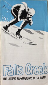 Falls Creek Historical Society
Booklet - Falls Creek THE ALPINE PLAYGROUND OF VICTORIA
... including names of several lodges and a map of the Tourist Village... including names of several lodges and a map of the Tourist Village ...This publication was released by the Falls Creek Tourist Area Management Committee during the 1969 snow season. It followed decisions to expand the accommodation and services to approximately double its size at that time. It was aimed at promoting the Resort in an effort to attract further interest and potential investment in this development.This brochure is significant because it documents the manner in which the Tourist Resort was prompted for investors.A fold out brochure with a skier on the front cover. The leaflet information about the size and location of Falls Creek including names of several lodges and a map of the Tourist Village on the back cover.Front cover: Falls Creek THE ALPINE PLAYGROUND OF VICTORIAfalls creek tourist resort, falls creek development, falls creek promotion -
 Phillip Island Conservation Society Inc.
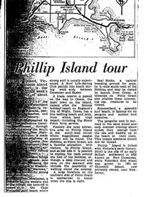
Work on paper - Photocopy of newspaper cutting, "Phillip Island tour", circa 1950s?
The article relates the journalist's visit to Phillip Island, starting from Melbourne and describing features along the way, then at San Remo on mainland side of Phillip Island bridge, then Newhaven on the other. Other places visited include the main town of Cowes, the jetty and beach there, and the Nobbies (Point Grant), with views of the Seal Rocks offshore through telescope at the Nobbies. The writer also visited Summerland beach, described as a surf beach, with penguin and mutton bird rookeries. While not specifically referring to the Penguin Parade, the writer says the spectacle of seeing the penguins coming ashore is not to be missed. The brief military colony at Rhyll and the first Victorian 'garden' planted at Churchill Island in 1801 are also mentionedArticle is significant because it is an early (1950s?) tourist guide to Phillip Island's most popular tourist destinations. 3 column text under map of Phillip Island. Black print on white paper. phillip island, newhaven, , westernport, surf beaches phillip island, summerland beach, penguins, mutton birds, the nobbies, point grant, seal rocks, cowes, nobbies blowhole, rhyll, churchill island, nobbies telescope -
 Harcourt Valley Heritage & Tourist Centre
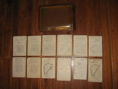
Field maps in case, 1914
Maps used in World War I by Col W E JamesPart of a large collection of items belonging to Col, W E James, of Harcourt, who after a career in the Militia, commanded Australian troops in WW1, both at Gallipoli and on the western Front. The entire collection includes books on military law and maps. Essential part of the commanding officer’s kit. Collection of 12 fold up war maps from Europe used during World War I; on linen backing. Brown leather case, transparent front cover, brass fastenings and loop for attaching to the belt -
 Wodonga & District Historical Society Inc
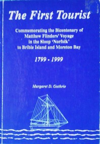
Book - The First Tourist, Margaret D. Guthrie, 1999
The full title of this publication is "The first tourist: commemorating the bicentenary of Matthew Flinders' voyage in the sloop Norfolk to Bribie Island and Moreton Bay, 1799-1999". It was sponsored by Pacific Harbour, Bribie Island with the assistance of the Regional Arts Development Fund. Although Flinders documented his voyage to Australia in his major work "Voyage to Terra Australia", little mention is made of his voyage to Bribie Island. However this publication claims Matthew Flinders as the first official tourist to Bribie Island. It was published to celebrate the bicentenary of his voyage.A book of 72 pages including plates, maps and illustrations. The cover is blue with white text and an illustration of a sailing sloop. It includes a bibliography.The full title of this publication is "The first tourist: commemorating the bicentenary of Matthew Flinders' voyage in the sloop Norfolk to Bribie Island and Moreton Bay, 1799-1999". It was sponsored by Pacific Harbour, Bribie Island with the assistance of the Regional Arts Development Fund. Although Flinders documented his voyage to Australia in his major work "Voyage to Terra Australia", little mention is made of his voyage to Bribie Island. However this publication claims Matthew Flinders as the first official tourist to Bribie Island. It was published to celebrate the bicentenary of his voyage.matthew flinders, flinders bicentenary, australia - exploration and settlement