Showing 2842 items
matching wests road
-
 Melbourne Tram Museum
Ephemera - Timetable, Melbourne & Metropolitan Tramways Board (MMTB), West Coburg - Domain Road - St Kilda Beach route, May. 1969
... West Coburg - Domain Road - St Kilda Beach route.... corner, for the West Coburg - Domain Road - St Kilda Beach route... scanned. West Coburg - Domain Road - St Kilda Beach route ...Timetable - listing the various runs, times at various timing point or locations for Essendon Depot, Weekdays as at 26-5-1969. Four photocopied pages stapled in the top left hand corner, for the West Coburg - Domain Road - St Kilda Beach route. On the rear of each sheet (all the same) details of the route, time points and changes for weekday peaks and Sundays. Front and back sheets scanned.Has number "17" in the top right hand corner - part of the index page.trams, tramways, mmtb, route 55, west coburg, domain rd -
 Ringwood and District Historical Society
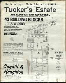
Card - Land Subdivision Clipping, Tucker's Estate, Ringwood, Vic. - 1913
... Street, Surrey Street, Yarmouth Street and West Prussia Road... Street, Surrey Street, Yarmouth Street and West Prussia Road ...Partially trimmed copy of a land subdivision auction advertisement on cardboard backing, with digitised copy of original flyer.Subdivision includes Thanet Street, Albert Street, Arlington Street, Barkly Street, Maidstone Street, Kirk Street, Vine Street, Surrey Street, Yarmouth Street and West Prussia Road (later Wantirna Road) Ringwood, Vic. Property names include Wandsworth, Ingleside, Lyndhurst and Karsruhe. Auctioneer and Estate Agents - Coghill & Haughton, 79 Swanston Street, Melbourne Auburn and Canterbury. Licensed Surveyor - W.P. Steane, M.C.E., 317 Collins Street, Melbourne. -
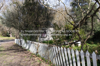
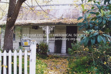 Eltham District Historical Society Inc
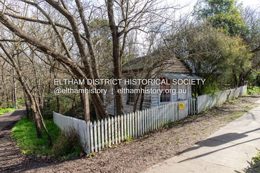
Photograph, Fay Bridge, Former Jarrold Cottage and Bootmaker's Shop, 701 Main Road, Eltham, n.d
... reserve west of Main Road (now present-day Wingrove Park Trail... road reserve west of Main Road (now present-day Wingrove Park ...Situated originally on the corner of the Dalton Street road reserve west of Main Road (now present-day Wingrove Park Trail), the former Jarrold Cottage (White Cloud) was purchased by Lena Skipper following Thekla Jarrold's death in 1943. It was built by William Jarrold in the early 1850s and was here that he married Hannah Coleman in 1856. The Bootmaker's shop was built by Thekla Jarrold in 1930 for use by her friend, John Clark, a local photographer who had boarded with the Jarrold family since about 1910. In 1930 he changed profession to a bootmaker and leather worker. The shop is one of only three remaining early 20th century shops in what was Little Eltham, the others being present-day San Antionio Barber Shop at 820 Main Road and Cafe Zen Den at 736 Main Road.fay bridge collection, bootmaker's shop, eltham, jarrold cottage, main road, shops, white cloud cottage, wingrove park trail -
 Eltham District Historical Society Inc
Photograph, Peter Pidgeon, White Cloud Cottage, 701 Main Road, Eltham, 2 Aug. 2022
... reserve west of Main Road (now present-day Wingrove Park Trail... road reserve west of Main Road (now present-day Wingrove Park ...Situated originally on the corner of the Dalton Street road reserve west of Main Road (now present-day Wingrove Park Trail), the former Jarrold Cottage (White Cloud) was purchased by Lena Skipper following Thekla Jarrold's death in 1943. It was built by William Jarrold in the early 1850s and was here that he married Hannah Coleman in 1856. The Bootmaker's shop was built by Thekla Jarrold in 1930 for use by her friend, John Clark, a local photographer who had boarded with the Jarrold family since about 1910. In 1930 he changed profession to a bootmaker and leather worker. The shop is one of only three remaining early 20th century shops in what was Little Eltham, the others being present-day San Antionio Barber Shop at 820 Main Road and Cafe Zen Den at 736 Main Road.Born Digitaleltham, main road, bootmaker's shop, jarrold cottage, white cloud cottage, shops, wingrove park trail -
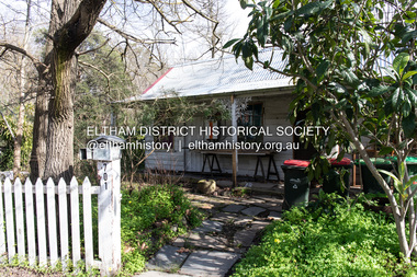
 Eltham District Historical Society Inc
Photograph, Peter Pidgeon, Former Bootmaker's shop, 701 Main Road, Eltham, 2 Aug. 2022
... reserve west of Main Road (now present-day Wingrove Park Trail... road reserve west of Main Road (now present-day Wingrove Park ...Situated originally on the corner of the Dalton Street road reserve west of Main Road (now present-day Wingrove Park Trail), the former Jarrold Cottage (White Cloud) was purchased by Lena Skipper following Thekla Jarrold's death in 1943. It was built by William Jarrold in the early 1850s and was here that he married Hannah Coleman in 1856. The Bootmaker's shop was built by Thekla Jarrold in 1930 for use by her friend, John Clark, a local photographer who had boarded with the Jarrold family since about 1910. In 1930 he changed profession to a bootmaker and leather worker. The shop is one of only three remaining early 20th century shops in what was Little Eltham, the others being present-day San Antionio Barber Shop at 820 Main Road and Cafe Zen Den at 736 Main Road.Born Digitaleltham, main road, bootmaker's shop, jarrold cottage, white cloud cottage, shops, wingrove park trail -
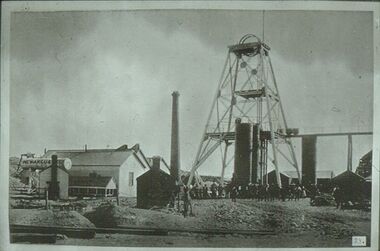 Bendigo Historical Society Inc.
Slide - ALBERT RICHARDSON COLLECTION: NEW ARGUS GOLD MINE, EAGLEHAWK
... Slide. New Argus Gold Mine, Eaglehawk, west of Sailor's... on bottom of slide. Slide. New Argus Gold Mine, Eaglehawk, west ...Slide. New Argus Gold Mine, Eaglehawk, west of Sailor's Gully Road. Image taken about 1906. Poppet head with elevated tramway, with ore cart on tracks. Engine room and boiler on LH side, brick chimney at rear. Large group of men standing at base of poppet head.No. 23 on bottom of slide.mine, gold, new argus., bendigo mines-jack hattam collection -
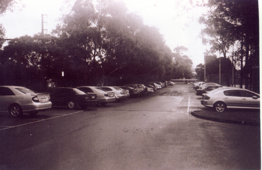 Whitehorse Historical Society Inc.
Photograph, Car Park - rear of Recreation Centre, 1/06/2009
... the Nunawading Station and the Springvale Road Railway crossing... on north side of railway line and west side of Springvale Road ...One of a collection of photographs taken of the Nunawading Railway Station prior to the lowering of the railway line and building of the new railway station on the western side of Springvale Road so that the Springvale Road Rail Crossing can be eliminated.Black & white photograph of he precinct surrounding the Nunawading Station and the Springvale Road Railway crossing. This photograph is of the car park on north side of railway line and west side of Springvale Road behind the Recreation Centre. This will be site of new station. See NP 3545 to NP3567 for the complete set of photographsnunawading railway station, springvale road nunawading, redevelopment of railway line/springvale road. -
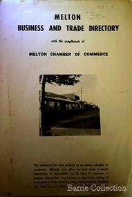 Melton City Libraries
Booklet, Melton Business and Trade Directory, c.1965
... “Darlingsford” 1911 Residence KILPATRICKS Road became Barries Road west... “Darlingsford” 1911 Residence KILPATRICKS Road became Barries Road west ...BUSINESS TRADE AND DIRECTORY MAP NORTH of High Street RALIEGHS Road - Early settlers Oliver Reierson ( Norwegian) Raliegh SHEBLER Court Auguste EMIL Court Jongebloed Family residence “Hemlich” ALEXANDRA Street Coronation King, Queen Alexandra - 1903 O’NEILS Road Farmer OLDERSHAW Road CORR Grove Early landowner, Teacher at the Common School – Denominational Churches, 1850’s Wesleyan (Methodist) BRYAN Court 1850’s resident renamed from earliest town site - Flat HURLEY Street Early settler and farmers - CHESNEY Road was named Minns, due to duplication altered to Chesney (Minns) SOUTH of High ALKEMADE Drive. Family name ARNOLD Court Family BARRIES Road Charles Ernest Barrie “Darlingsford” 1911 Residence KILPATRICKS Road became Barries Road west of Station Road BLACKWOOD Drive Alexander, Early settler CALLANAN Drive Surveyor early LUBY Court John Luby - Crown Grant Land title KERWIN Street Michael - Crown Grant land title (deleted due to Freeway)Pamphlet of Melton Businesses and map of the townlocal identities, misc., council -
 Melbourne Tram Museum
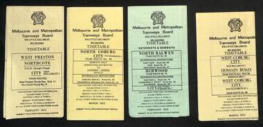
Ephemera - Timetables - MMTB trams - set of 7, Melbourne & Metropolitan Tramways Board (MMTB), 1972
... - Feb. 1972 4 - West Coburg - Domain Road and West Coburg City... - Domain Road and West Coburg City on Sundays - routes 55, 56 ...Timetables - provide information on ticketing, fares, timing points, with a description of the route and a map. 1 - West Preston - Northcote - City - routes 9, 10, 11 - Feb. 1972 2 - North Coburg with connecting bus to Fawkner and Gowrie - Upfield on Sundays route 19, 20 and 18 - March 1972 3 - North Balwyn Burwood - City - routes 48, 40, 41, 37, 74, 75, 76, 28 - Feb. 1972 4 - West Coburg - Domain Road and West Coburg City on Sundays - routes 55, 56 and 68 - March 1972 5 - West Maribyrnong - City - (bus routes on Sunday only) - routes 57, 54, 60, 58 and 50 - Feb. 1972 6 - Essendon Aerodrome - City - route 49, 49, 52 and 51 - March 1972 7 - Footscray - Moonee Ponds - bus route on Saturday afternoons and Sundays - route 82 Feb. 1972Yields information about MMTB tram services during 1972Set of seven MMTB tram timetables - multifolded printed on yellow or green paper.timetable, mmtb, route 10, route 9, route 11, route 19, route 18, route 20, route 48, route 40, route 41, route 37, route 74, route 75, route 76, route 28, route 55, route 56, route 68, route 57, route 54, route 60, route 58, route 50, route 59, route 49, route 52, route 51, route 82 -
 Whitehorse Historical Society Inc.
Newspaper - Article, Post Office, 1983
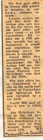
... to the North West corner of Canterbury Road and Springvale Road... to the North West corner of Canterbury Road and Springvale Road ...Article in Nunawading Gazette about the first Post Office in Forest Hill. The first postmistress was Catherine Peacock (and storekeeper) who died in the 1930's. Later the P.O. was transferred to the North West corner of Canterbury Road and Springvale Road. The first Post Office and store was located at 259 Canterbury Road and this building was demolished in 1950.post offices, peacock, catherine, mcarthur, archibald, canterbury road, forest hill, no 259, forest hill post office -
 Surrey Hills Historical Society Collection
Photograph, Holy Trinity Church of England, Surrey Hills post 1926, After 1926
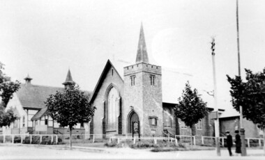
... the south-west corner of Guildford Road. Further up the hill... taken from near the south-west corner of Guildford Road. Further ...St George's Church of England, Mont Albert was built in 1886 and from 1904 until 1907 was known as Holy Trinity, Surrey Hills. As the population increased there was a need for a church in Surrey Hills. This brick church was consecrated in 1922 and replaced the earlier one built in 1907 on the adjacent site in Union Road. After construction of the brick church, the earlier one became a Sunday School. The copper spire was added in 1926, which dates this photo as post-1926. Norman Carter took many photos of Surrey Hills and Mont Albert in the 1920s; many were associated with events and activities of the Church of England.Black and white photo of the 'newly' constructed brick Holy Trinity Church in Union Road, Surrey Hills taken from near the south-west corner of Guildford Road. Further up the hill is the earlier church. Both buildings are bounded by a simple post and rail fence. Immature street trees are planted on both sides of Union Road.churches, holy trinity church, anglican church, sunday schools, norman carter -
 Eltham District Historical Society Inc
Photograph, Peter Pidgeon, Former Bootmaker's shop and White Cloud Cottage, 701 Main Road, Eltham, 2 Aug. 2022
... reserve west of Main Road (now present-day Wingrove Park Trail... road reserve west of Main Road (now present-day Wingrove Park ...Situated originally on the corner of the Dalton Street road reserve west of Main Road (now present-day Wingrove Park Trail), the former Jarrold Cottage (White Cloud) was purchased by Lena Skipper following Thekla Jarrold's death in 1943. It was built by William Jarrold in the early 1850s and was here that he married Hannah Coleman in 1856. The Bootmaker's shop was built by Thekla Jarrold in 1930 for use by her friend, John Clark, a local photographer who had boarded with the Jarrold family since about 1910. In 1930 he changed profession to a bootmaker and leather worker. The shop is one of only three remaining early 20th century shops in what was Little Eltham, the others being present-day San Antionio Barber Shop at 820 Main Road and Cafe Zen Den at 736 Main Road. Part of a presentation by Peter Pidgeon to the Society, 13 August 2022 showcasing a series of photographs taken by John Henry Clark over the period 1895 to 1930.Born Digitaleltham, main road, bootmaker's shop, jarrold cottage, white cloud cottage, shops, wingrove park trail -
 Eltham District Historical Society Inc
Photograph, Peter Pidgeon, Former Bootmaker's shop, 701 Main Road, Eltham, 2 Aug. 2022
... reserve west of Main Road (now present-day Wingrove Park Trail... road reserve west of Main Road (now present-day Wingrove Park ...Situated originally on the corner of the Dalton Street road reserve west of Main Road (now present-day Wingrove Park Trail), the former Jarrold Cottage (White Cloud) was purchased by Lena Skipper following Thekla Jarrold's death in 1943. It was built by William Jarrold in the early 1850s and was here that he married Hannah Coleman in 1856. The Bootmaker's shop was built by Thekla Jarrold in 1930 for use by her friend, John Clark, a local photographer who had boarded with the Jarrold family since about 1910. In 1930 he changed profession to a bootmaker and leather worker. The shop is one of only three remaining early 20th century shops in what was Little Eltham, the others being present-day San Antionio Barber Shop at 820 Main Road and Cafe Zen Den at 736 Main Road. Part of a presentation by Peter Pidgeon to the Society, 13 August 2022 showcasing a series of photographs taken by John Henry Clark over the period 1895 to 1930.Born Digitaleltham, main road, bootmaker's shop, jarrold cottage, white cloud cottage, shops, wingrove park trail -
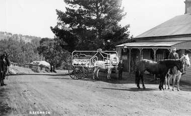 Eltham District Historical Society Inc
Negative - Photograph, Tom Prior (prob.), West's Research Hotel, Main Road, Research, c.1907
... West's Research Hotel, Main Road, Research, near site... melbourne West's Research Hotel, Main Road, Research, near site ...West's Research Hotel, Main Road, Research, near site of present pre-school centre. General Store on left. (Destroyed by fire 1931) Note sign for State Electoral Halls. Most likely taken on Election Day 1907 by Tom Prior, who also took the Election Day photos in Eltham near the Eltham Hotel. This photo forms part of a collection of photographs gathered by the Shire of Eltham for their centenary project book,"Pioneers and Painters: 100 years of the Shire of Eltham" by Alan Marshall (1971). The collection of over 500 images is held in partnership between Eltham District Historical Society and Yarra Plenty Regional Library (Eltham Library) and is now formally known as the 'The Shire of Eltham Pioneers Photograph Collection.' It is significant in being the first community sourced collection representing the places and people of the Shire's first one hundred years.Digital image "4 x 5 inch B&W Neg 120 format B&W negative" Print 15.5 x 25.5 cmshire of eltham pioneers photograph collection, research (vic.), research hotel, general store -
 Kew Historical Society Inc
Plan, Survey Plan, Park Hill Road, Kew, 1880-1890
... , Park Hill Road East, Park Hill Road West in Kew were each... Road East, Park Hill Road West in Kew were each gazetted ...The streets identified on the survey plan - Cotham Road, Park Hill Road East, Park Hill Road West in Kew were each gazetted by the Victorian Government in 1865. The hand-coloured survey plan was completed by Holland Loxton, Town Clerk and Surveyor of the Borough of Kew from 1866. The unnamed survey plan includes names of land owners in addition to measurements (2 chains to 1 inch) and streets. Named owners include Webster, Payne and Francom which will enable us to narrow down the creation date of the survey.Handdrawn survey plan by a former surveyor and town clerk of KewHand drawn and coloured survey plan created by Holland Loxton, Surveyor and Town Clerk of Kew, showing land owned by Payne in Park Hill Road, Kew. The plan includes street names, land measurements and land owners.surveys - kew, maps - kew, holland loxton, park hill road - kew, holland loxton -- surveyor, survey plans -- parkhill road -- kew (vic.) -
 Eltham District Historical Society Inc
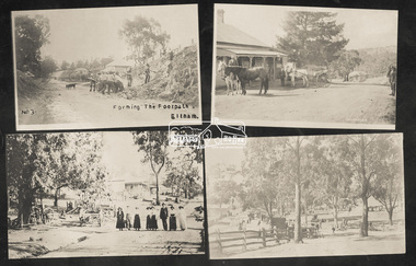
Photograph, Tom Prior, Group of scenes from the Eltham District, c.1905
... Photograph Collection: SEPP_0501: West's Research Hotel, Main Road... Photograph Collection: SEPP_0501: West's Research Hotel, Main Road ...Photo shows four images from the Shire of Eltham Pioneers Photograph Collection: SEPP_0501: West's Research Hotel, Main Road, Research, c.1907 SEPP_0612: Eltham, Main Road. Looking north from corner of Dudley Street, c.1904 SEPP_0616: Forming the footpath, Eltham, c.1906 SEPP_1000: Main Road, Hurstbridge, c.1905 Black and white/sepia photograph of four individual photographsbakery, eltham, eltham village reserve, footpath, gahan house, general store, haley's paddock, hurstbridge, luther haley, luther haley general store, main road, old mac (horse), picnic, pioneers and painters, punch (horse), railway store, research (vic.), research hotel, reynolds prior collection, richard reynolds, road construction, sepp, shire of eltham pioneers photograph collection, summer drinks, tilley lamp, york street -
 City of Kingston
Photograph - Black and white, c. 1957
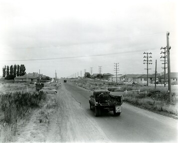
... Black and white photograph looking west along South Road... photograph looking west along South Road. There is a truck ...This image shows the urbanisation of a formerly rural area of Moorabbin.Black and white photograph looking west along South Road. There is a truck in the foreground, travelling along the sealed South Road. A car is waiting to exit from Rowan Road. People are walking along the left hand side of the road, and a young person a bike is riding along the right side. They are all going in the same direction as the traffic. The left hand side of the image shows paddocks in the foreground, which houses further back. The right hand side of the image shows suburban houses with electricity poles running the length of the road. Handwritten in blue ink on reverse: 57-523A Handwritten in red ink on reverse: 85% Handwritten in black ink or grey lead: Ch. 6moorabbin, cars, roads, housing -
 Melbourne Tram Museum
Photograph - Set of 3 Colour Negatives, Phil A'Vard, 10/02/1962 12:00:00 AM
... Street and Summerhill Road, West Footscray. Taken on Perutz... cars at the corner of Barkly Street and Summerhill Road, West ...Set of 3 photographs taken on the AETA Sat. 10/2/1962 - Closure of the Local Tram Routes at Footscray. .1 - X1 in Hopkins Street Footscray, has the Duci Bros electrical store?, and the Hoyts Trocadero Theatre in the background. .2 - X1 468 and another X1 in Barkly Street with the Footscray Drill Hall in the background .3 - X2 677 and two X1 cars at the corner of Barkly Street and Summerhill Road, West Footscray. Taken on Perutz film - see 3997 for the AETA Tour circular.trams, tramways, footscray, aeta, tours, barkly st, x1 class, x2 class, tram 468, tram 677, tram 467, hopkins st -
 Surrey Hills Historical Society Collection
Photograph, Union Road, Surrey Hills in 1982 (3), 1982
... on the west side of Union Road beyond the intersection; also... on the west side of Union Road beyond the intersection; also ...Taken in January 1982; very similar to SHP0628 & SHP0635. Surrey Family Hotel (McNeill's Family Hotel) was built in 1888 by Alexander McNeill. It closed as a hotel after the Local Option vote in 1920. The Surrey Squash Courts were built in what had been the Surrey Theatre. The facade of the ANZ Bank building documents the past history of the building having earlier been the ES&A Bank. Black and white photo of Union Road at the intersection of Canterbury Road. On the right the edge of Dartnell's Pharmacy building on the SE corner can be seen and McNeill's Family Hotel building (pre-renovation) on the NE corner. Distinguishable advertising signs include the ANZ Bank and Dalkeith Office Supplies on the west side of Union Road beyond the intersection; also the Surrey Squash Courts.businesses, shops, union road shops, dartnell's pharmacy, mcneill's family hotel, surrey family hotel, anz bank, surrey gardens, dalkieth office supplies, surrey squash courts -
 Whitehorse Historical Society Inc.
Photograph, Nunawading Brownie Guiders in Mitcham Shopping Centre, Late 1950s - Early 1960s
... on the north side of Whitehorse Road, west of Mitcham Road.The traders... of Whitehorse Road, west of Mitcham Road.The traders shown in the photo ...Black and white photo of Nunawading Brownie Guiders at a parade in Mitcham Shopping Centre. Photo shows the Mitcham shops on the north side of Whitehorse Road, west of Mitcham Road.The traders shown in the photo, left to right, Claude Richards-Draper; D.G.Williamson - Fruiterer; Bob Dorien - Chemist in same building as Williamson; Hay and Corn Store - ???; and Norman & Sons-Grocer.Across Mitcham Road is Barrie George - Milk Bar; Fish Shop- ??? and Ken Herbert - Grocer; the Mitcham Memorial Hall is on the east side.It is estimated that the photo was taken in the late 1950s or early 1960s.richards, claude, dorien, bob, williamson, d.g., norman & sons, george, barrie, herbert, ken, fish shops, mitcham memorial hall, gardiner, shirley, floyd, peg, quick, judith, elsworth, jean, lynette, brown, evelynne, hogben, pam, sue, yarrow, erica -
 Ballarat Tramway Museum
Photograph - Black & White Photograph/s, Chris Wurr, late 1960's or early 1970's
... ) and tram stop sign on west side of road. Photocopy made 4/1999...) and tram stop sign on west side of road. Photocopy made 4/1999 ...Yields information about the tram crossover point in Albert St Sebastopol during the last few years of the tramways and the condition of the roadway at the time.Black and White photograph of SEC tram No. 12 crossing Albert St. from east to west side at Ophir St. late 1960's or early 1970's. Tram has destination of SEBASTOPOL, and Twin Lakes sign on rear. Photo taken after tram has passed photographer. Photo by Chris Wurr. Photo shows sealed road (to Colac) and tram stop sign on west side of road. Photocopy made 4/1999 for display purposes. Copy 2 added 27/7/2007, ex Alan Bradley photographs.On rear, in black stamp ink "Photo by Chris Wurr / 12 Truscott Street, Ararat 3377 / (053) 523403 Copy 2 - Additional words to above "Donated to BTPS by and"trams, tramways, albert st., sebastopol, tram 12 -
 Uniting Church Archives - Synod of Victoria
Photograph, Rev Alan Body, 1988
... , to Coombah on the Broken Hill road, out west to the South Australian..., to Coombah on the Broken Hill road, out west to the South Australian ...Rev Alan Body ministered at Wentworth (the Victorian parish in New South Wales) for 10 years, and was subsequently transferred to Boort. During his time at Wentworth he conducted a patrol ministry, travelling between 8000 and 10,000 kilometres per year visiting the area from Wentworth to Pooncarie, to Coombah on the Broken Hill road, out west to the South Australian border, south to the Murray and upstream to Wentworth.B & W waist length photograph of Rev. Alan Body with his Wentworth Shire Australia Day Citizen Award."Alan Body page 31 C&N 24/2/1988"rev alan body -
 Surrey Hills Historical Society Collection
Photograph, Union Road, Surrey Hills in 1982 (1), 1982
... and the ANZ Bank on the west side of Union Road beyond... and the ANZ Bank on the west side of Union Road beyond ...Taken in January 1982; very similar to SHP0635. Surrey Family Hotel (McNeill's Family Hotel) was built in 1888 by Alexander McNeill. It closed as a hotel after the Local Option vote in 1920. Vic Dartnell joined his cousin Percy Cathcart in a pharmacy on the opposite corner in 1936 and moved it to this corner in 1940. His son John followed as the pharmacist and then his daughter Amanda. After the Dartnell family sold the business, the pharmacy continued in a similar manner as a compounding pharmacy and retained 'Dartnell' in its name. Black and white photo of Union Road at the intersection of Canterbury Road. On the left the edge of the Surrey Gardens can be seen and on the right the Dartnell's Pharmacy building on the SE corner and McNeill's Family Hotel building (pre-renovation) on the NE corner. Distinguishable advertising signs include V A Dartnell, Vozzo's Supa Valu Licenced Supermarket on the NW corner and the ANZ Bank on the west side of Union Road beyond the intersection.businesses, shops, union road shops, dartnell's pharmacy, mcneill's family hotel, surrey family hotel, vozzo's licenced supa valu supermarket, anz bank, surrey gardens, vic dartnell, john dartnell, amanda dartnell -
 Surrey Hills Historical Society Collection
Postcard - Union Road, Surrey Hills looking north
... to the west down Canterbury Road. McNeill's Family Hotel, the Surrey... to the west down Canterbury Road. McNeill's Family Hotel, the Surrey ...Surrey Family Hotel (McNeill's Family Hotel) was built in 1888 by Alexander McNeill. It closed as a hotel after the Local Option vote in 1920.A colour post card from a watercolour sketch of the intersection of Union and Canterbury Roads looking north towards Mont Albert Road. It shows bluestone guttering edging the road in the foreground. Children are gathered under the verandah on the SW corner of the intersection and on the road. A horse drawn vehicle is seen travelling to the west down Canterbury Road. McNeill's Family Hotel, the Surrey Hall and part of Hansen's Terrace can be seen. Advertising signs for Otto Preuss (undertaker) and A R B Cuest (baker) can be partly seen. In the distance scattered houses and open space can be seen.Front: Printed on the post card "Union Rd. Surrey Hills, looking North" Rear: "BOX HILL HISTORICAL SOCIETY" (stamp) and "Mrs E W Zerbe / Williamson Rd. / Doncaster" in biro. This is possibly Marjorie Morgan's writing. "POST WTP (within cartouche) CARD" and "Printed / in / Germany" printed on card.mcneill's family hotel, bakers, undertakers, surrey hall, surrey theatre, rex theatre, mr a r b cuest, mr otto preuss -
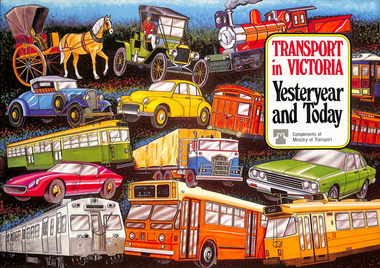 Melbourne Tram Museum
Book, Ministry of Transport, "Transport in Victoria - Yesteryear and Today", 1980
... , transport interchanges, West Gate Bridge, Roads and Freeways..., the underground loop, transport interchanges, West Gate Bridge, Roads ...Pamphlet or Book - 20 pages, full colour printed on gloss paper, centre stapled titled "Transport in Victoria - Yesteryear and Today", published by the Ministry of Transport giving an outline of Victoria's transport history from 1834. Provides a short history of the state transport system, railways, roads, trams, Metropolitan planning, the Bland report, social changes, the underground loop, transport interchanges, West Gate Bridge, Roads and Freeways, transport inquiry of 1980 and environmental changes resulting from motor cars. 2nd copy added 14-5-2016 from the estate of Charles Craig.trams, tramways, minister for transport, railways, trb, crb, murla, planning, history -
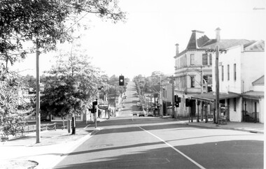
 Eltham District Historical Society Inc
Postcard - Photograph, The Rose Stereograph Company, The Bridge, Eltham, c.1939
... Looking west across the Main Road Bridge over the Diamond... melbourne Looking west across the Main Road Bridge over the Diamond ...Looking west across the Main Road Bridge over the Diamond Creek at Eltham, c.1939. The car in the foreground, possibly the photographer's, is a Ford Model C Ten built by Ford UK between 1934 and 1937. The Model C was released in Australia in 1935. The Ford Model C Ten is a car that was built by Ford UK between 1934 and 1937. The Model C was released in Australia in 1935 https://en.wikipedia.org/wiki/Ford_Model_C_TenPostcardValentine Series No.3196diamond creek (creek), ford model c ten, main road bridge, postcard, valentine series postcard, bridge, cars, eltham, eltham south, main road, motor vehicles, rose stereograph, rose stereograph company -
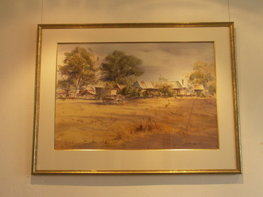 Friends of Westgarthtown
Painting, John Borrack, Last Days Ziebells "The Pines" Thomastown
... . The large pines beyond, sheltered the farmyard on the west...Friends of Westgarthtown 100 Gardenia Road Thomastown ...Painted from the home (or front) paddock which ran south to the creek. The paddock was used for the cultivation of lucerne and maize crops in the lower regions while closer to the house where Ainwick Crescent is now situated, it was a burgeoning market garden for the cultivation of all varieties of vegetables. The large pines beyond, sheltered the farmyard on the west of Gardenia Road. That complex can be partly glimpsed on the left of the painting. This is a directly painted watercolour relying on the use of white paper and transparencies to impart a feeling of morning light. The figure is the artist's mother for whom the picture was painted. Provenance: Augusta Borrack (nee Ziebell) Collection, John Borrack CollectionWatercolour painting, depicting Ziebell's Farmhouse from the south (Thomastown and Mernda). Painting is mounted in a gold frame with cream board.Artist signature: John Borrack; Last Days at Ziebells "The Pines" Thomastown, 'Pro mea matre hanc picturan feci (In Memoria)'illustrations, watercolours, john borrack, ziebell, watercolour, painting -
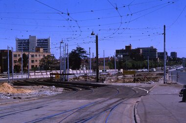 Melbourne Tram Museum
Slide - Set of 2, Keith Kings, 24/12/1967 12:00:00 AM
... - Dandenong Road west from Hornsby St with section of straight track... freeway work .2 - Dandenong Road west from Hornsby St ...Set of two 35mm Kodak white cardboard colour slide by Keith Kings of 24/12/1967 - .1 - St Kilda Junction, looking north along St Kilda Road, showing the nature of the diversion from the junction for Wellington St. .2 - Dandenong Road, showing the track diversion work for Dandenong Road/Queensway, Windsor.Keith Kings stamp and number "15-1" and "15-5"", with details of exposure. .1 - SW6 car on temporary track at St Kilda Junction looking north from turnout during freeway work .2 - Dandenong Road west from Hornsby St with section of straight track ready to replace curves onto new b.v.w. track to Chapel St - 907 coming off soon to be abandoned street track.trams, tramways, st kilda junction, trackwork, road works, dandenong road, queensway, tram 907 -
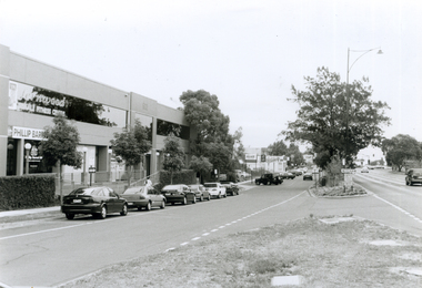 Whitehorse Historical Society Inc.
Photograph, Whitehorse Road looking South, 2000
... of Whitehorse Road looking West wards towards corner of Mitcham Road... and negative of Whitehorse Road looking West wards towards corner ...Produced as one of a series of 24 prints commissioned by Nunawading & District Historical Society -|Theme: Intersections of Mitcham and Nunawading 2000/2001.|See also Series by P. Simmenauer on the same theme.Black and white photograph - print and negative of Whitehorse Road looking West wards towards corner of Mitcham Road - along service road in Whitehorse Road. From left - right - buildings: Fernwood Female Fitness Centre above offices of Phillip Baressi, Federal Member of Parliament; Hertz Car Rental Yard; Telstra Mobile Shop; Mr. Muffler; Pedders Suspension; Mitcham Hotel. Parallel and angle parking in service road.baressi, phillip, fernwood female fitness centre mitcham, hertz - car rental, telstra, mr muffler, pedders suspension, mitcham hotel -
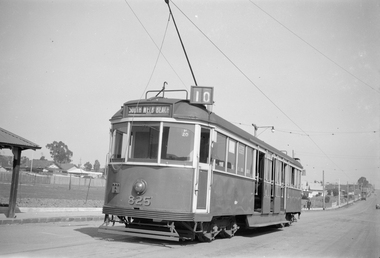 Melbourne Tram Museum
Negative - Set of 2, Ellis Collection, c1940
... Set of two Negatives (120) of W5 825 at the West Preston...Melbourne Tram Museum 8 Wallen Road Hawthorn melbourne ...Set of two Negatives (120) of W5 825 at the West Preston Terminus, Gilbert Road, before Regent St. c1940. Note the "T" shaped lights on the tram - these were a red reflector - see page 104 of Destination City 5. Tram has the destination of South Melbourne Beach, route 10 and has a run number of P20 showing. Hi Res image filed in the dbtext/hawthtramcoll/Large Images/htd3606i1 and i2Large.jpgtrams, tramways, west preston, gilbert rd, w5 class, gilbert rd, route 10, tram 825