Showing 2558 items
matching aerial
-
 Eltham District Historical Society Inc
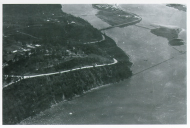
Photograph - Aerial Photograph, Landata, Eltham, Vic, Apr. 1972
Centred on present day Diamond Creek Trail at the Eltham Leisure Centre bounded by Central Park to north, Main Road at Falkiner Street to south, MacMahon Ball Paddock to east and Grand Boulevard at Buena Vista Drive to west. Historic Aerial Imagery Source: Landata.vic.gov.au Aerial Photo Details: Project No :985 Project : MELBOURNE 1972 Run : 28 Frame : 207 Date : 04/1972 Film Type : B/W Camera : RC10 Flying Height : 5700 Scale : 9600 Film Number : 2635 GDA2020 : 37°43'25"S, 145°08'20"E MGA2020 : 335985, 5823223 (55) Melways : 21 G7 (ed. 42)aerial photo, neil webster collection, 1972-04, eltham, buena vista drive, central park, diamond creek trail, eltham leisure centre, falkiner street, grand boulevard, macmahon ball paddock, main road, melway 21g7 -
 Eltham District Historical Society Inc
Photograph - Aerial Photograph, Landata, Eltham, Main Road; Mt Pleasant Rd to Railway Rd, Dec. 1945
Centred on Main Rd and Henry St, Eltham bounded by Railway Road to north, Mount Pleasant Road at Main Road to south, top of the hill in Arthur Street to east and Karingal Drive at Sherbourne Road to west. Historic Aerial Imagery Source: Landata.vic.gov.au Aerial Photo Details: Project No :65 Project : MELBOURNE AND METROPOLITAN PROJECT NO. 2 Run : 8 Frame : 70 Date : 01/1951 Film Type : B/W Camera : EAG9 Flying Height : 12200 Scale : 12000 Film Number : 1419 GDA2020 : 37°43'06"S, 145°08'45"E MGA2020 : 336589, 5823811 (55) Melways : 21 J6 (ed. 42)aerial photo, eltham, main road, henry street, arthur street, bolton street, eltham-yarra glen road, neil webster collection, 1951-01, dave lyon house, ernie andrew house, karingal road, melway 21j6, mount pleasant road, railway road -
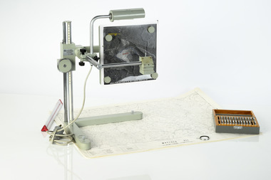 Department of Energy, Environment and Climate Action
Zeiss Sketchmaster
The Zeiss Sketchmaster was used to transfer information from aerial photographs onto scale maps. The operator views the aerial photograph and the map simultaneously and manually traces detail from the photograph onto the map. It utilises the principle of the camera lucida, patented in 1806. Various lens combinations were used on a to adjust for scale and then “rubber sheet” the image to line up topographic features like streams and roads. The photo information was then laboriously transferred using a light table onto large A0 paper maps or translucent drafting film. The maps were later hand coloured with either Derwent pencils or delicately painted with Pelikan ink wash. This item is kept at Erica.Zeiss Sketchmaster. c1970s. Includes adjustable stand, various lens in sperate box, adjustable light, map holder and magnetsforests commission victoria (fcv), forest measurement, mapping, surveying -
 Glenelg Shire Council Cultural Collection
Pamphlet - BROCHURE, Portland Aluminium Smelter, n.d
Two tri-fold brochures produced by Portland Aluminium. Contains history, economic importance, and manufacturing information. Black and white. Blue 'PORTLAND ALUMINIUM SMELTER' on front, above aerial photo of smelter. Back has diagram of smelter, area marked with blue numbers to match legend.portland aluminium smelter -
Port Melbourne Historical & Preservation Society
Photograph - Aerial view of cruise ships at Port Melbourne piers, 13 Feb 2001
This photograph records the concurrent visit to Station Pier of three cruise ships - the peak of the Cruising Victoria strategy aimed at encouraging cruise shipping to Melbourne. Also the Devil Cat was berthed at Station Pier on this day but not in the photo (4 ships in one day)Aerial colour photograph taken by The Age, showing from left to right, cruise ships Regal Princess, QE2 and Silver Cloud, all at Station Pier on 13 February 2001. An unusual persective showing the rear of 'The Anchorage', formerly Swallow and Ariell, also Stokes and Princes Streetspiers and wharves - station pier, transport - shipping, rms queen elizabeth 2, qe2, swallow & ariell ltd, regal princess, silver cloud -
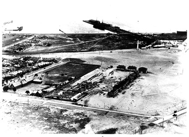
Port Melbourne Historical & Preservation Society
Photograph - Aerial view of Port Melbourne, circa 1928
Aerial photo of Port Melbourne c1928 focusing on the Gas Works area spanning Port Melbourne and Albert Park. Shows the finally filled Lagoon, and area from the Harpers Starch factory to Foote St, Albert Park and from the bay to just over Richardson/Liardet Stssandridge lagoon, built environment - industrial, industry, gasworks, joshua brothers distillery, harpers starch factory -
 Port Melbourne Historical & Preservation Society
Photograph - Aerial view of first Bank Houses in Garden City, 1927
Photographic copies from black and white aerial photograph of the building of the first State Savings Bank Houses in Garden City 1927, showing also Graham Street State School, Princes Pier, Graham Street and Williamstown Road, west wing of Station Pier ("Rotomahana" at pier)built environment - domestic, fishermans bend, garden city, education - primary schools, melbourne harbor trust - port of melbourne authority, state savings bank of victoria, graham street state school, port melbourne primary school, bank houses -
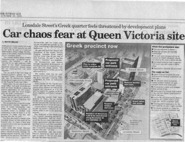 Queen Victoria Women's Centre
Newspaper excerpt, The Sunday Age, Car Chaos fear at Queen Victoria Site: Lonsdale Street's Greek quarter feels threatened by development plans, 29 October 2000
Newspaper excerpt from The Sunday Age. Page 5 and a smaller introduction probably from the front page. Smaller excerpt colour photo of blue-stone and cast-iron wall which was to be demolished. Larger excerpt, a black and white aerial view of QVWC and the block where it is situated. building construction, building permits, historic building -
 Port Melbourne Historical & Preservation Society
Photograph - Aerial view of Swallow and Ariell factory, Port Melbourne, c. 1950
The Sandridge Marine Lodge was founded in 1858. Two locations; originally Stokes St and then in Liardet St from 1917. Both buildings are now converted to apartments. .03 - Aerial photo of Swallow and Ariell factory, with Stokes St Lodge building visible on right hand side of photobuilt environment - civic, built environment - domestic, societies clubs unions and other organisations, built environment - industrial, freemasons lodge, swallow & ariell ltd, sandridge marine lodge -
 Lakes Entrance Historical Society
Photograph - Kalimna, Bulmer H D, 1940c
Black and white photograph of aerial view of Kalimna Heights, showing scattered buildings, Princes Highway around side of cliff, western end of township, North Arm bridge, footbridge to Bullock Island, and rock groynes. Track to lookout and signal beacon visible. Lakes Entrance Victoria waterways, roads and streets, bridges, township -
 National Vietnam Veterans Museum (NVVM)
Photograph, Gibbons, Denis, Fire Support Base Harrison
Denis Gibbons (1937 – 2011) Trained with the Australian Army, before travelling to Vietnam in January 1966, Denis stayed with the 1st Australian Task Force in Nui Dat working as a photographer. For almost five years Gibbons toured with nine Australian infantry battalions, posting compelling war images from within many combat zones before being flown out in late November 1970 after sustaining injuries. The images held within the National Vietnam Veterans Museum make up the Gibbons Collection.A black and white photograph of an oblique aerial view of the Australian Fire Support Base Harrison, Operation Pinnaroo. The FSB provided a battalions direct artillery and mortar support, to the infantry, on operations away from 1st ATF at Nui Dat, Phuoc Tuy Province. (Circa March 1968)photograph, fire support base harrison, operation pinaroo, 1st atf base, nui dat, phuoc tuy province, denis gibbons, gibbons collection, fsb harrison -
 Kiewa Valley Historical Society
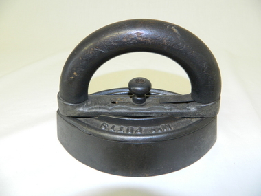
Iron - Flat, Circa early 1900s
Historically this item was used before the spirit and the electrical iron took over Circa 1930s -1950s. The main body of the iron was placed on a flat heated surface of a stove (wood, coal or gas fired). It was mainly used by women in their domestic role, ironing the family clothes and linen. In the Kiewa Valley the supply of coal or gas was not available or too expensive than the locally cut hard wood trees. This particular iron was an improvement on the fixed handled iron because it allowed (by use of its easily detachable handle) to use multiple bases and thereby allowing a constant heat supply to be maintained and not having to waste time for a base to reheat to the required level of application.The significance of this item was that it allowed for a faster method of ironing clothes and linen. It's invention was a progress towards reducing the time it took to undertake a very labour and intensive domestic function. The reduction of time taken for this household duty provided women great flexibility to undertake other activities. These type of improvements to basic domestic tasks liberated housewives not only physically but also mentally from the isolation of the home environment.This flat iron has a removable, clip-on handle. The handle and its release knob are of wood. The base of the handle together with the heavy flat body are made of cast iron. The body of the iron is oval shaped tapered at each end and is 40mm thick.Underneath the handle frame and on the main body, on one side, in raised lettering is "Mrs Potts" and on the other side "Iron". Both are clearly visible when viewed from an aerial position. Under removable handle and on a plate (screwed onto the main body) is "No 2"iron, antique, household, pressing clothes, domestic, laundry -
 Anglesea and District Historical Society
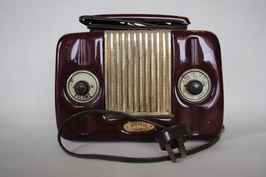
Radio, Breville Sydney, Breville Gem, 1950
Model 903 - Broadcast Receiver - past WW2 Tuner. Valves and tubes - GAN7, EBF35, GM5, 6x4 Principle: Super-Heterodyne ZF/IF 452KHz Wave Bands: Broadcast only (MW) Power: AC 220/240 Volt Loudspeakers: Permanent Magnetic Dynamic (PDyn) Loudspeaker (moving coil) Colour: RedBack: Internal Aerial Socket Model 903 Front: Left Dial - OFF VOLUME. Front: Right Dial - AK, MAAW, C SDB, LO, CO, G1, AR UZ, KZSR, XY BN CV; BATR HA UL WV -
 Bendigo Military Museum
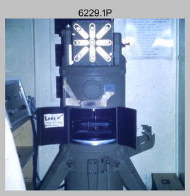
Photograph - Photo Troop Equipment, Lithographic Squadron – Army Survey Regiment, Fortuna, Bendigo, c1970s
This collection of five photos was most likely taken at Lithographic Squadron, Army Survey Regiment, Fortuna, Bendigo in c1970s. The main tasks undertaken by technicians in Photo Troop were most likely enlargements, reductions and duplication of map reproduction material, and processing of aerial photography.This is a set of five photographs of Photo Troop equipment was taken in Lithographic Squadron, at the Army Survey Regiment, Fortuna, Bendigo, c1970s. The photographs are on 35mm colour slides and were scanned at 96 dpi. They are part of the Army Survey Regiment’s Collection. .1) - Photo, colour, c1970s, WILD U4A Diapositive Camera. .2) - Photo, colour, c1970s, Hass-Labortechnik Film and Paper Roller Transport Processor. .3) - Photo, colour, c1970s, Hass-Labortechnik Film and Paper Roller Transport Processor, SGT Christopher Wardley. .4) - Photo, colour, c1970s, Hass-Labortechnik Film and Paper Roller Transport Processor, unidentified technician. .5) - Photo, colour, c1970s, Pako Film Processor..1P to .5P – Some of the equipment is annotated on the frame of the 35mm slides.royal australian survey corps, rasvy, army survey regiment, army svy regt, asr, fortuna, litho -
 Bendigo Military Museum
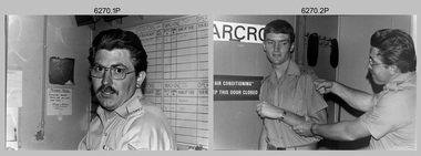
Photograph - Photo Troop, Lithographic Squadron – Army Survey Regiment, Fortuna, Bendigo, c1983
This collection of seven photos was most likely taken at Lithographic Squadron, Army Survey Regiment, Fortuna, Bendigo in c1983. The main tasks undertaken by technicians in Photo Troop were most likely enlargements, reductions and duplication of map reproduction material, and processing of aerial photography.This is a set of seven photographs of Photo Troop personnel and equipment from Lithographic Squadron at the Army Survey Regiment, Fortuna, Bendigo, c1983. The photographs were on 35mm negative film and were scanned at 96 dpi. They are part of the Army Survey Regiment’s Collection. .1) - Photo, black & white, c1983, Photo Troop work area, SGT Garran Hill. .2) - Photo, black & white, c1983, Photo Troop work area, L to R: SPR Steve Burke, SGT Garran Hill. .3) - Photo, black & white, c1983, Photo Troop work area, SPR Steve Burke. .4) - Photo, black & white, c1983, Photo Troop work area, WO1 Noel ‘Nesty’ Coulthard. .5) - Photo, black & white, c1983, Photo Troop work area, WO1 Noel ‘Nesty’ Coulthard. .6) - Photo, black & white, c1983, Photo Troop work area, CPL Gary Tremain. .7) - Photo, black & white, c1983, Photo Troop work area, CPL Neville Carr. No personnel are identified.royal australian survey corps, rasvy, army survey regiment, army svy regt, fortuna, asr, litho -
 Bendigo Military Museum
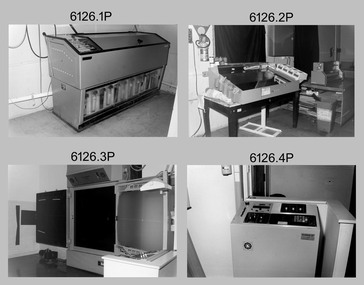
Photograph - Photo Troop, Lithographic Squadron – Army Survey Regiment, Fortuna, Bendigo, 1986
This collection of 18 photos was most likely taken at Lithographic Squadron, Army Survey Regiment, Fortuna, Bendigo in 1986. The main tasks undertaken by technicians in Photo Troop were most likely enlargements, reductions and duplication of map reproduction material, and processing of aerial photography.This is a set of 18 photographs of Photo Troop personnel and equipment from Lithographic Squadron at the Army Survey Regiment, Fortuna, Bendigo, 1986. The photographs were on 35mm negative film and were scanned at 96 dpi. They are part of the Army Survey Regiment’s Collection. .1) - Photo, black & white, 1986, Film developer. .2) - Photo, black & white, 1986, Chromalin Proof equipment. .3) - Photo, black & white, 1986, KLIMSCH Commodore camera. .4) - Photo, black & white, 1986, KLIMSCH Commodore camera operator’s console. .5) - Photo, black & white, 1986, Film contact frame. .6) - Photo, black & white, 1986, Film processing chemicals. .7) - Photo, black & white, 1986, Unidentified technician. .8) - Photo, black & white, 1986, L to R: Unidentified technician, SPR Russell Pajank, SPR Carmel (Butler) Fauth. .9) - Photo, black & white, 1986, SPR Carmel (Butler) Fauth. .10) - Photo, black & white, 1986, SPR Carmel (Butler) Fauth. .11) - Photo, black & white, 1986, L to R: CPL Paul Baker, SGT Rob Bougumil. .12) - Photo, black & white, 1986, CPL Paul Baker. .13) - Photo, black & white, 1986, CPL Paul Baker. .14) - Photo, black & white, 1986, L to R: CPL Paul Baker, CPL Brian Paul. .15) - Photo, black & white, 1986, L to R: CPL Frank Lenane, SGT Rob Bougumil. .16) - Photo, black & white, 1986, CPL Brian Fauth. .17) - Photo, black & white, 1986, WO1 Trevor Osborne. .18) - Photo, black & white, 1986, L to R: SPR Kerron South, SGT Rob Bogumil.No personnel are identifiedroyal australian survey corps, rasvy, army survey regiment, army svy regt, fortuna, asr, litho -
 Bendigo Military Museum
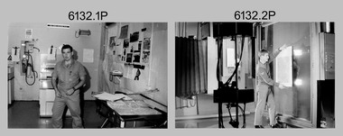
Photograph - Photo Troop, Lithographic Squadron – Army Survey Regiment, Fortuna, Bendigo, 1988
This collection of 10 photos was most likely taken at Lithographic Squadron, Army Survey Regiment, Fortuna, Bendigo in 1988. The main tasks undertaken by technicians in Photo Troop were most likely enlargements, reductions and duplication of map reproduction material, and processing of aerial photography.This is a set of 10 photographs of Photo Troop personnel and equipment from Lithographic Squadron at the Army Survey Regiment, Fortuna, Bendigo, 1988. The photographs were on 35mm negative film and were scanned at 96 dpi. They are part of the Army Survey Regiment’s Collection. .1) - Photo, black & white, 1988, BARCRO work area, SPR Gary Sievers. .2) - Photo, black & white, 1988, KLIMSCH Commodore camera, CPL Mick Gillham. .3) - Photo, black & white, 1988, KLIMSCH Commodore camera, CPL Mick Gillham. .4) - Photo, black & white, 1988, WILD U4A Diapositive Camera, SPR Rob Jones. .5) - Photo, black & white, 1988, WILD U4A Diapositive Camera, SPR Rob Jones. .6) - Photo, black & white, 1988, WILD U4A Diapositive Camera, SPR Rob Jones. .7) - Photo, black & white, 1988, WILD U4A Diapositive Camera, SPR Rob Jones. .8) - Photo, black & white, 1988, WILD U4A Diapositive Camera, SPR Rob Jones. .9) - Photo, black & white, 1988, Photographic camera enlarger, unidentified technician. .10) - Photo, black & white, 1988, SUPER CHROMEGA F Photographic camera enlarger. No personnel are identifiedroyal australian survey corps, rasvy, army survey regiment, army svy regt, fortuna, asr, litho -
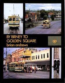 Ballarat Tramway Museum
Book, Brian Andrews, "By Birney to Golden Square", 1973
Features both black and white and colour photographs, including tickets, photos along each route, Charing Cross, depot, notes on the rolling stock with an aerial photograph of Bendigo with the tram routes marked in and a fold out detailed map of Bendigo and its track layout.Yields information about the Bendigo tramways operated by the SEC in a photographic and text format.Book, 78 pages including card cover, printed on gloss paper, titled "By Birney to Golden Square", written by Brian Andrews, published by Southern Cross Traction, Kensington Park SA. Sub-titled "The last last years of Bendigo's tramways", 1973. trams, tramways, bendigo, sec tramways, maps -
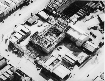 Ballaarat Mechanics' Institute (BMI Ballarat)
Aerial view buiding of Civic Hall 1960's
This photograph is from the Max Harris Collection held by the Ballaraat Mechanics' Institute. Please contact BMI for all print and usage inquiries.ballarat, aerial, construction, civic hall, 1960s, doveton, armstrong, mair -
 Eltham District Historical Society Inc
Photograph - Aerial Photograph, Landata, Eltham, Feb. 1956
Centred on present day Culla Hill and Petty's Orchard, Eltham bounded by Brougham Street and Mount Pleasant Road to north, Monckton Road, Templestowe to south, Reynolds Road to east and Eltham Lower Park and Hohnes Road to west. Historic Aerial Imagery Source: Landata.vic.gov.au Aerial Photo Details: Project No :250 Project : MELBOURNE OUTER SUBURBS PROJECT Run : 18 Frame : 92 Date : 02/1956 Film Type : B/W Camera : EAG9 Flying Height : 10000 Scale : 12000 Film Number : 1176 GDA2020 : 37°43'35"S, 145°09'31"E MGA2020 : 337735, 5822959 (55) Melways : 22 B8 (ed. 42)aerial photo, 1956-02, neil webster collection, eltham, brougham steet, culla hill, eltham lower park, hohnes road, melway 22b8, monckton road, mount pleasant road, petty's orchard, reynolds road, sweeneys lane, templestowe, yarra river -
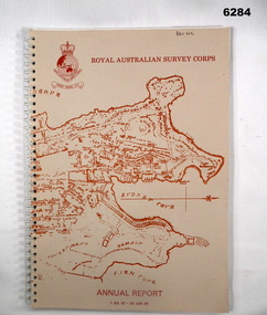 Bendigo Military Museum
Booklet - Royal Australian Survey Corps - Annual Report 1 Jul 87 - 30 Jun 88, Director of Military Survey -Army, 01.09.1988
Royal Australian Survey Corps Annual Report detailing Surveying and mapping activities 1 July 87 - 30 Jun 88. The first part of the report details the highlights during the period followed by Annexes A to J detailing Australian Map and Chart production. Annex A: 45 pages, Annex B: 1 page Aust Doppler Satelite Stations, Annex C: 1 page, Aust airborne Profile Recording, Annex D: 1 page Aust Aerial photography, Annex E: 1 page Aust Analytical Aerotriangulation, Annex F: 1 page Inertial Positioning System Network Traverses Fils Svy, Annex G: 1 page Global Positioning System Station/networks TI4100 Svy, Annex H: 1 page, Defence Cooperation Programme, Annex I 3 Pages RASvy Officer Manning, Annex J: 1 page RASvy ARES Manning Levels.Buff coloured light cardboard covers. Old map of Sydney Cove area printed in red/brown on front cover and Survey Corps Badge in red top left corner. "Map of the town of Sydney 1836" printed on back cover. A4 sized paper pages, 17 numbered pages plus, Annex A: 45 x pages, Annex B: 1 x page Aust Doppler Satellite Stations, Annex C: 1 x page, Aust Airborne Profile Recording, Annex D: 1 x page Aust Aerial photography, Annex E: 1 x page Aust Analytical Aerotriangulation, Annex F: 1 x page Inertial Positioning System Network Traverses Fils Svy, Annex G: 1 x page Global Positioning System Station/Networks TI4100 Svy, Annex H: 1 x page, Defence Cooperation Programme, Annex I 3 x pages RASvy Officer Manning, Annex J: 1 x page RASvy ARES Manning Levels.royal australian survey corps, rasvy, fortuna, army survey regiment, army svy regt, asr -
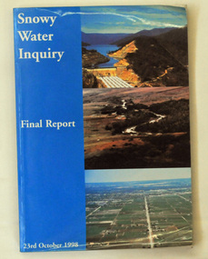 Orbost & District Historical Society
book, Snowy Water Inquiry, Snowy Water Inquiry Final Report, 1998
The Snowy Water Inquiry was commissioned in 1998 with a brief to recommend environmental water release options to the Commonwealth, Victorian, and NSW Governments so that corporatisation of the Snowy Mountains Scheme could proceed. These release options related to the Snowy River below Jindabyne, the Murray River and other rivers associated with the Scheme. The Inquiry objectives were that the recommendations would not adversely impact on water supplies to existing irrigators or the viability of the Snowy Mountains Scheme. (ref snowyhydro.com.au)This report contains information about water allocation and uses of the Snowy River.A book of 160 pp - Snowy River Inquiry Final report 23rd October 1998. Submitted to the Governments of New South Wales and Victoria / Commissioner: The Hon. Robert Webster. On the front cover are three aerial photographs of the Snowy River and Snowy Hydro Scheme. The book contains maps and photographs. snowy-river snowy-hydro snowy-mountains government-inquiry -
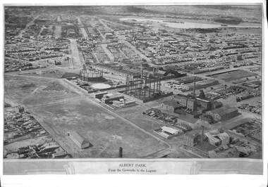 Port Melbourne Historical & Preservation Society
Photograph, E C Joshua, Albert Park from the Gasworks to the Lagoon, 1921
Rare copy of E C JOSHUA and Captain LARKIN work."Albert Park from the Gasworks to the Lagoon" Copy of aerial photography 1921 of former lagoon area taken by E C JOSHUA (photographer) and Captain H J LARKIN (pilot). "Views from an Aeroplane" black and white copy. Plus separate sheet giving brief description of photographtransport - aviation and aerodrome, sandridge lagoon, natural environment, recreation, built environment, parks and gardens, e c joshua, h j larkins, gasworks, schumaker mill furnishing works, pump house, sugar shed, joshua bros distillery -
Port Melbourne Historical & Preservation Society
Photograph - aerial view of Port Melbourne, 1942
The Mathews family have been in continuous ownership of 395 Howe Parade (was 8 Howe Parade until 1964 when addresses re-assigned), Port Melbourne from 1938 to the present (Sept 2019)Six folders of assorted documents relating to the life of Alan Mathews and his family. Employment documents. Folder 6 has photographs. Two photocopies of aerial photos of Port Melbourne. Copy 1 has Howe Parade; C.O.R. tanks; Engine Works; First Point and piers markeddomestic life, alan mathews -
Whitehorse Historical Society Inc.
Map, Melbourne Metropolitan Area Base Map series. Sheet 214, c1960
Map showing northern section of the City of Nunawading together with parts of Shire of Doncaster and Templestowe.Map showing northern section of the City of Nunawading together with parts of Shire of Doncaster and Templestowe. Shows roads, creeks, block numbers and contours at 5 feet vertical increments. Note on map: 'prepared ... from State Aerial Survey, January 1957 and Cadastral Survey information February 1959'.Map showing northern section of the City of Nunawading together with parts of Shire of Doncaster and Templestowe. maps, city of nunawading, shire of doncaster and templestowe -
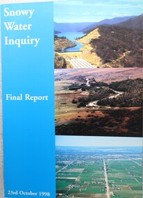 Wodonga & District Historical Society Inc
Book - Snowy Water Inquiry Final Report 23rd October 1998, Robert Webster et al, 1998
The Snowy Water Inquiry was commissioned in 1998 with a brief to recommend environmental water release options to the Commonwealth, Victorian, and NSW Governments so that corporatisation of the Snowy Mountains Scheme could proceed. This book contains the findings of the Inquiry into water allocation and uses of the Snowy River.A book of 160 pp - Snowy River Inquiry Final report 23rd October 1998. Submitted to the Governments of New South Wales and Victoria / Commissioner: The Hon. Robert Webster. On the front cover are three aerial photographs of the Snowy River and Snowy Hydro Scheme. The book contains maps and photographs.non-fictionThe Snowy Water Inquiry was commissioned in 1998 with a brief to recommend environmental water release options to the Commonwealth, Victorian, and NSW Governments so that corporatisation of the Snowy Mountains Scheme could proceed. This book contains the findings of the Inquiry into water allocation and uses of the Snowy River.snowy river hydro, snowy river government inquiry, water allocations, water resources developmen -
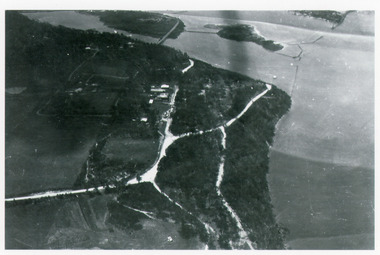 Lakes Entrance Historical Society
Photograph - Kalimna, Bulmer H D, 1940c
Black and white photograph of aerial view of Kalimna escarpment, Princes Highway, road to Kalimna Hotel, scattering of buildings including Gainsborough House, in distance is North Arm bridge, footbridge to undeveloped Bullock Island with rock groynes in place. Part of eastern pier of entrance at Lakes Entrance, Victoria. waterways, topography, township, bridges -
 Bendigo Historical Society Inc.
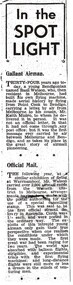
Newspaper - BASIL WATSON COLLECTION: NEWSPAPER CUTTING RE THE LIFE OF BASIL WATSON, 29th November, 1950
Newspaper cutting ''In the Spotlight'' re life of Basil Watson. Cuttings enclosed in cream envelope, on front ' Aeronautical notes re Basil G. Watson and other's Bendigo Advertiser of Nov 29th 1950. Paragraph headings: Gallant Airman; Official Mail; The Letter; Aerial Exhibition; Stunting; Finale.person, bendigo, basil watson -
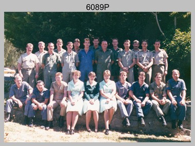 Bendigo Military Museum
Photograph - Photo Troop, Lithographic Squadron - Army Survey Regiment, Bendigo, 1989
This is a photograph of Photo Troop, Lithographic Squadron; one of the Army Survey Regiment’s four squadrons, at Fortuna, Bendigo, December 1989. The main tasks undertaken by Photo Troop’s technicians were most likely photographic enlargements, reductions and duplication of map reproduction material, and processing of aerial photography.This is a photograph of Photo Troop Lithographic Squadron, Army Survey Regiment at Fortuna, Bendigo, 1989. The colour photograph was printed on photographic paper and is part of the Army Survey Regiment’s Collection. The photograph was scanned at 300 dpi. Back Row L to R: Rob Bogumil, Kevin ‘Chuck’ Berry, Andrew ‘Morrie’ Morrison-Evans, unidentified, Greg Howell, unidentified, Damien Cole, unidentified, Warren ‘Waldo’ Shirley, Steve Burke, Paul Baker, Bob Garritty, Frank Lenane, Bill Jones. Front Row L to R: John Bragg, Ken Peters, Gavin Craggs, Michelle Withers, Penny Knott, Di Chalmers, Geoff Webb, unidentified, Darren ‘Barney’ Maher, Kim Reynolds. No personnel are identified. Annotated on back with ‘Photo Troop Dec 1989’royal australian survey corps, rasvy, army survey regiment, army svy regt, fortuna, asr, litho -
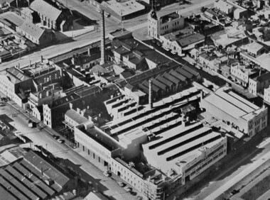
Port Melbourne Historical & Preservation Society
Document - Chemicals for Industry, J Kitchen & Sons, 1960s
Kitchens. Blue covered ringbinder labelled "Chemicals for Industry". General information and sections on each product. Data sheets in each section give details of chemical makeup of each product and suggested applications. Early section called "the Kitchen Story" includes an aerial view photo with names of all buildings.industry, manufacturing, built environment - industrial, j kitchen & sons pty ltd, f g pott - managing director, unichema