Showing 31183 items
matching building a
-
 Bendigo Historical Society Inc.
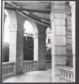
Photograph - BENDIGO HOSPITAL
black and white image: brick forecourt, edged in stone building, with curved arches. Appears like walkway around building.bendigo, buildings, hospital, bendigo, hospital -
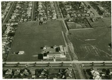 NMIT (Northern Melbourne Institute of TAFE)
Photographs: PTS Admin Building c1940s aerial view, Photographs: Preston Technical School Administration Building c1940s aerial view
Two black and white photographs of aerial view of Building A (Administration Building) Preston campus of Preston Technical School c1940s. preston technical school, buildings, nmit -
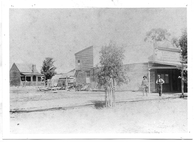 Tarnagulla History Archive
Photograph of P. Master's premises, Tarnagulla, P. Master's premises, Tarnagulla, Late 19th Century
Murray Comrie Collection. Information collated by Murray Comrie: Premises of P. Masters, cabinet-maker and funeral undertaker in Commercial Road, next to Cheetham's on the north side. Phillip Masters' Store was located in Commercial Road, opposite and south of the Victoria Theatre. This photograph is a reasonable copy created from an older original. Copy probably made by Murray Comrie in the 1970s. Monochrome photograph depicting a building with shopfront, two men standing in front. View past building to a small cottage in background.tarnagulla, commerce, shops, stores, masters, p. masters, funerals, commercial road, main street -
 Port Melbourne Historical & Preservation Society
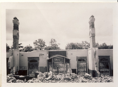
Photograph - West and rear wall balcony, first floor, Administration Building, J Kitchen & Sons, Port Melbourne, Lionel Layfield, 2014 - 2015
Photographs taken by ex-employee of Kitchen's, Lionel Hayfield (refer catalogue numbers 3411 and 3412) just before the building sold to "The Block" - a Channel 9 TV program. See also cat nos 3846, 3847 and 3848First floor series of colour photographs taken inside and from the J Kitchen & Sons Administration Building, Ingles St, Port Melbourne. Details where possible are on the back of the photographs. .12 -.16 West and rear wall balcony and windowsindustry - manufacturing, built environment - commercial, built environment - industrial, demolitions, j kitchen & sons pty ltd -
 Warrnambool and District Historical Society Inc.
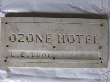
Plaque, Ozone Hotel, 1890
The building to which this tablet was attached was erected in 1890 as the Grand Ozone Coffee Palace. It was at the corner of Koroit and Kepler Streets in Warrnambool and was the most splendid edifice ever erected in Warrnambool. Initially it was a Temperance Hotel but in 1891 it gained a colonial wine licence. Thomas Randall was the lessee and proprietor of the building from 1894 to 1907 and from 1895 on it was called the Ozone Hotel. Mrs Lillias Euphemia Thom was the proprietor from 1907 to 1910. The tablet described herein has her name incised on the tablet ‘L.E.Thom’. The hotel was closed in 1915 and re-opened in 1920 with the new name of Hotel Mansions. The proprietor at that time was Howard Lawson. In 1923 Hotel Mansions gained a full hotel licence but in 1929 the building was destroyed by fire. The present day Hotel Warrnambool now occupies the site of the Hotel Mansions. This tablet is of great significance as it is an important memento of the Grand Ozone Coffee Palace/Ozone Hotel/Hotel Mansions. This building was the most elegant building ever to be erected in Warrnambool and, as such, a reminder of the type of luxury accommodation offered to visitors to Warrnambool in the late 19th and early 20th centuries. This was a time when Warrnambool was promoted as a spa resort with hot and cold sea baths and bracing sea breezes. The marble tablet is an indication of the splendor of the hotel’s furnishings and accoutrements. This is a rectangular marble slab with incised gold lettering (now somewhat faded). The bottom lettering is contained in a slight groove in the marble. There are four holes at each corner and six smaller holes along the edges of the tablet for attachment by screws to a building. The slab has some staining and a little rust. ‘Ozone Hotel’ ‘L.E.Thom’ grand ozone coffee palace (warrnambool), ozone hotel (warrnambool), hotel mansions, history of warrnambool, lillias thom -
 Halls Gap & Grampians Historical Society
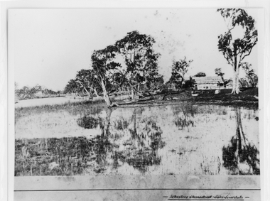
Photograph - B/W, c 1869
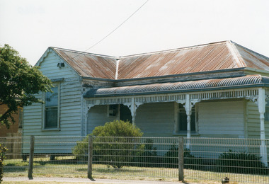
Photo is said to be of Schoolers' homestead,Lake Lonsdale. Miss Scouller was the teacher at Halls Gap Primary school in 1921.Spelling of Schooler varies from that on front of photo to 'Scouller' which appears in book "Bridging the Gap'.Photo shows bark roofed building on a bank of a body of water . A number of large gum trees surround the buildings-- tree reflections can be seen in the water. There appears to be extensive fencing around the buildings. The homestead is not visible.buildings, houses -
 Port Melbourne Historical & Preservation Society
Photograph - State Savings Bank of Victoria, Bay Street, Port Melbourne, 1950s
COPYRIGHT PUBLIC RECORDS OFFICE Digital copy of black and white photo of State Savings Bank of Victoria in Bay Street. Building was remodelled approximately 1957. Riall Bros Printers building is to the right of the bank building.built environment - commercial, state savings bank of victoria, bay street, business and traders - printers, riall brothers pty ltd -
 Bendigo Historical Society Inc.
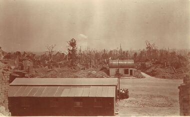
Postcard - ACC LOCK COLLECTION: SEPIA PHOTO OF BATTLEFIELD WITH RAOD AND BUILDINGS, POSTCARD, 1914-1918
Postcard, WW1, Sepia image of a battlefield. Two intact buildings, one on each side of a dirt road. Destroyed buildings in the background amongst trees. A group of six people outside the front building. Location unknown.postcard, postcard, ww1, france, battlefield -
 Hume City Civic Collection
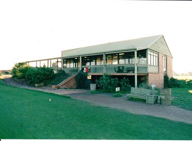
Photograph, early 1980s
The series of photographs were taken shortly after the opening of the newly established Goona Warra Golf Club in the early 1980s. The golf club was part of the Goonawarra Housing Estate which was developed on the area previously known as Goonawarra Farm. The new golf club replaced 'The Pines' which was part of the Caloola complex.A coloured photograph of the front view of Goonawarra Golf Club's clubrooms. The building is on 2 levels with a large balcony across the front. Native plants have been planted around the building and a gravel path leads to the building.goona warra golf club, george evans collection -
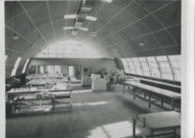 Kilmore Historical Society
Photograph, 88-90 Sydney Street
17.5cm x 12.5cm black and white photograph of the Spicers Paper Manufacturer building. Captured is the inside of the building which has work benched and cabinets. The building is a domed structure, similar to an aircraft hanger and wooden flooring. paper manufacturing, architecture -
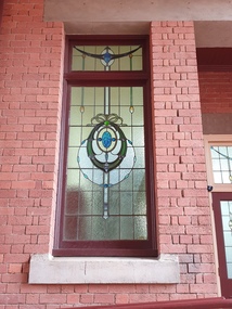 Federation University Historical Collection
Photograph, Clare Gervasoni, Stained Glass window at the Ballarat School of Mines, 04/2020
The Ballarat Technical Art School building was opened in 1915. It is not known when the stained glass was put into position.Colour digital photograph showing the stained glass at the Ballarat Technical Art School. The mining lamp detail is on the entrance door to the Ballarat School of Mines Technical Art School building. The design features three tools associated with mining, the miners lamp and two hammers. Their is also stained glass on the entrance doors and a window by the entrance.ballarat school of mines, ballarat technical art school, stained glass, miners lamp, entrance -
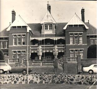 Hume City Civic Collection
Photograph, c 1974
The photograph is one of a series of mounted photographs which have been used for display purposes.A black and white photograph of the administration building of the former Sunbury Asylum. It is a tweo storey brick building with a slate roof and three gables. One of the gables is an attic. The wooden trims are white. A brick colonade fence is in front of the building with a terraced roadway in the foreground. Three cars are parked in the front of the building. Mounted on board.sunbury asylum, george evans collection -
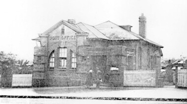 Surrey Hills Historical Society Collection
Photograph, Surrey Hills Post Office
The post office opened at this location in 1912. It was demolished in 2000. Post office history in the area: Until 1883 when the railway came through to Surrey Hills, this was essentially a rural community of scattered farms. Land subdivisions soon occurred along the railway line and limited postal services followed soon after, although a ‘permanent’ home for the post office was two decades away. George Sim Junior is acknowledged as our first postmaster; he opened a post office on 1 October 1884 in his father’s general store at 619-621 Canterbury Road, a few doors down from the Surrey Hills Hotel on the corner of Union Road. Over the next 20 years, the Surrey Hills Post Office moved several times into temporary, shared accommodation – in 1889 into Woodhead’s Corner Store at 364 Canterbury Road; then in 1895 to No 376, Hansen’s Exchange Building, part of Hansen’s Terrace (demolished) and in 1901 to 109 Union Road, on the corner of Windsor Crescent. Following Federation in 1901, the new Commonwealth Government established the Postmaster-General's Department to provide postal services to the nation. Many of the post offices constructed in the following years reflected a growing sense of Australian pride and nationalism. It was 1914 when building commenced on the ‘purpose-built’ post office at 609 Canterbury Road, Surrey Hills. Described as “a polychromatic Federation Freestyle building”, it served as the local post office for nearly 85 years until sold by the Commonwealth Government in c1999, after which the post office moved to the current, less prominent site at 100 Union Road. For nearly 10 years under private ownership, the building was successfully adapted for use as the base for two businesses, Gargoyles and Dragons and later the Surrey Sculpture Studio, and fortuitously the historic integrity of the building was maintained. However although renovated in the 1990's, structurally sound and of historic significance, it was not protected under local or commonwealth heritage legislation and was demolished soon after sale. This is an early image of a demolished building which should have been protected. In 1991, when the City of Camberwell conducted a heritage study, (which still informs the basis of the City of Boroondara’s heritage guidelines for this part of the municipality,) the post office was owned by the Commonwealth Government. As such, it could not be considered for heritage listing by the local authorities. Some years later, the Commonwealth and Australia Post rather belatedly recognized not only that post offices have heritage and social value, but also that the architecture of post offices as community buildings is important. A heritage management scheme was developed for the buildings they own or control under the Environment Protection and Biodiversity Act 1999. Unfortunately, the Surrey Hills Post Office had been sold and demolished before this was finally enacted in 2004. Black and white image, perhaps from a post card, of Surrey Hills post office at 609 Canterbury Road. The building is flanked by a picket fence. There is a woman, a dog and a man in front of the entrance. The man is in uniform - possibly a postal employee.post offices, canterbury road, businesses, surrey hills post office, surrey sculture studio, gargoyles and dragons -
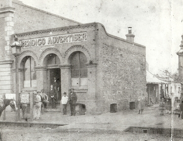 Bendigo Historical Society Inc.
Photograph - BENDIGO ADVERTISER BUILDING, 1850's ?
black and white photo ( copy ). Brick building with two arched windows alongside arched single doorway. At rear of building, a weatherboard attached building. Children standing on RH side of photo, seven men standing at front of building. Horse tied to lamp post at front of building. In photo on board in front of scene 'The Weekly|Advertiser|Electioneering|Intelligence|The ?rang Election|???' See Research field for further information.batchelderorganization, business, bendigo advertiser, bendigo advertiser. haverfield, robert ross. lloyd, arthur moore. fletcher, george avery. -
 Orbost & District Historical Society
black and white photograph, C 1922
DESCRIPTIONA black / white photograph on a grey buff cardboard frame. It is of a group of students standing outside the Orbost State School building. One child holds a sign reading "Form F". There is a photographer's label at the bottom.SIZEH-199mm W-028mmOBJECT REGISTRATION890KEYWORDSeducation-orbost orbost-state-schoolHISTORICAL INFORMATIONThe 19th of March 1886 proved an important day in the lives of many early settlers in the Orbost area, because on this day the Orbost State School opened. The fact that the school had first operated temporarily in a leased building, and on a half-time basis with SS2745 Jarrahmond, did not dampen the enthusiasm of the local inhabitants as they saw their offspring commence their education under the guidance of HT Campbell Mackay. However he remained in charge only until 12th of May 1886. The second HT, John Rowe, served until 1908. On 30th of June 1887, a portable room was provided; it being brought to the area by schooner. The school now had accommodation for 30 pupils; the teacher's welfare was considered because quarters of two rooms were attached. As the population increased so did the needs of the school. This was reflected in the provision of a larger classroom in 1898. During 1910-11 the first approaches were made to the Department for the establishment of a HES in Orbost and this became a reality in 1912. Orbost HES supplied post-primary education in the district until a high school was built in 1948. When fire destroyed the school in 1941 local halls were used as classrooms until a new school was built. Work was quite rapid and a new brick structure was opened by the Hon. A. E. Lind, MLA, on 13th of February 1942. This new building was a fine type of school of which both the pupils and the HT Leslie Collins were indeed proud. But Orbost continued to develop and the new school was soon overtaxed. This resulted in the erection of two Bristol classrooms in 1947. By 1950, when the school population had reached 500 pupils the opening of the new school at Orbost North was welcomed by all concerned. In 1963 the Department purchased land diagonally opposite the school and developed it as a playing area. In 1965 two LTCs were opened in November, and in October 1968 the Brodribb School building was moved to SS2744 Orbost for use as a general purpose room. ( Info. from Schools East Gippsland)This item is associated with the history of education in Orbost.A black / white photograph of a large group of children standing outside a school building - " Orbost State School No. 2744". The younger students are standing in the front. High School students are at the back.on back - "Mr C. Connor S.M. Mr Tipper H.M. State & H.E.s. about 1922"education-orbost orbost-state-school orbost-higher-elementary-school -
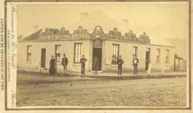 Bacchus Marsh & District Historical Society
Photograph, Court House Hotel Main Street Bacchus Marsh 1883
This building on the corner of Court House Place and Main Street Bacchus Marsh has been a licensed hotel since 1864. Prior to 1864 the building was in use as a saddlery business. By 1911 the hotel had been re-built in brick and a second storey had been added. The identities of the five men and one woman in the photo are not known. The woman at the left of the group is possibly Ann Tanner who was the licensee around the time this photograph was taken. Small sepia unframed photograph on card with gold border framing photograph. Housed in the album, 'Photographs of Bacchus Marsh and District in 1883 by Stevenson and McNicoll'. A group of five men and one woman can be seen standing in front of the Court House Hotel building, Main Street Bacchus Marsh.On the front: Stevenson & McNicoll. Photo. 108 Elizabeth St. Melbourne. COPIES CAN BE OBTAINED AT ANY TIME. On the back: LIGHT & TRUTH inscribed on a banner surmounted by a representation of the rising sun. Copies of this Portrait can be had at any time by sending the Name and Post Office Money Order or Stamps for the amount of order to STEVENSON & McNICOLL LATE BENSON & STEVENSON, Photographers. 108 Elizabeth Street, MELBOURNE. stevenson and mcnicoll 1883 photographs of bacchus marsh and district, hotels bacchus marsh, court house hotel bacchus marsh -
 Surrey Hills Historical Society Collection
Book, Visions of a Village : Canterbury shops and shopping 1880s-1990s, 1995
Focussing on the growth and activities that took place in the shopping and service centre of Canterbury and Maling Roads in Canterbury from the 1880s to the present, it is partly a guide book to the present buildings of the centre through the streetscapes and brief lives of each of the premises.Focussing on the growth and activities that took place in the shopping and service centre of Canterbury and Maling Roads in Canterbury from the 1880s to the present, it is partly a guide book to the present buildings of the centre through the streetscapes and brief lives of each of the premises. illus. of streetscapes, indexshops, canterbury, maling road, (mr) george robinson, rochester road, j weymouth, railways, m white, hindson buildings, (mrs) - hillier, f g wilson, s huckerby, g cox, (mr) george cornell, lawson brothers, retail trade, commercial development -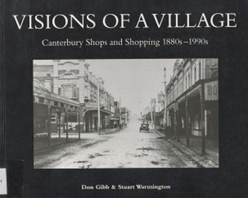
 Surrey Hills Historical Society Collection
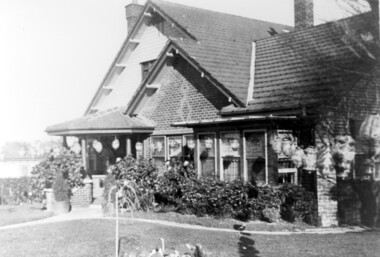
Photograph, Home and surgery of Dr William Langley Carrington, 174 Union Road, 1935
The building was erected in c 1913 as a home / surgery for Dr James L Blakie (1868-1937), who originally lived / practised across the road. It was designed by architect Arthur William Plaisted (1890-1965) and is an early example of attic-style Californian bungalow style. Dr Carrington ( 1900-1970) succeeded Dr Blakie and practised at 174 Union Road from 1930-1970. Now known as the Surrey Hills Medical Centre.Black and white photo of the surgery and home of Dr and Mrs William Langley Carrington at 174 Union Road on the corner of Guildford Road, Surrey Hills.. The exterior of the building is decorated with paper lanterns around the windows and veranda for the Empire Day celebrations in 1935. The building is 2 storey, of brick construction with a tiled roof and front porch. It has a bay window front right. Shadows indicate the photo was taken early morning in winter.medical services, guildford road, union road, dr william langley carrington, mr arthur plaisted, dr james landells blakie, californian bungalow, dr bill carrington -
Port Melbourne Historical & Preservation Society
Book, Water works, Trust - Inwards Correspondence, 1890s
Originally a correspondence record for the Warracknabeal Waterworks, this book was recycled for use as a visitors' register for the Missions to Seamen building, during the years the Mission Arts Centre occupied it (1987 - 1990). Included are signatures of visitors during the Bicentenary celebrations, January 1988 as well as casual visitors and attendees at exhibitions, performances, concerts, community days, private parties, etc.Large bound volume, blue with tan leather binding, stamped in gold "Water Works, Trust - Inwards Correspondence", used as visitors' register for the Mission Arts Centre, Missions to Seamen building 1987-89missions to seamen, mission arts centre -
Federation University Historical Collection
Document, Ballarat Junior Technical School Building
The Ballarat Junior Technical School, a division of the Ballarat School of Mines, was established in 1913 and moved into a new, custom built building in 1921.Four photographs of the newly completed Ballarat Junior Technical School. .1) Drawing of a plan for a building on the Ballarat Gaol site in 1947 .2) Newspaper photographs of entrance to the Ballarat Junior Technical School .3 & .4) Plans for the Ballarat Junior Technical School on the Gaol Reserve drawn by George Crawley in 1934. ballarat junior technical school -
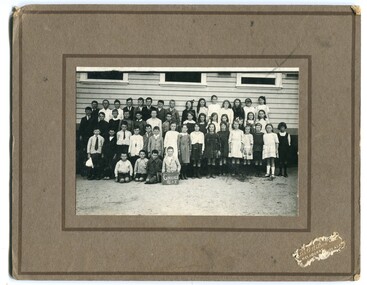 Orbost & District Historical Society
black and white photograph, Wilson, Les G, C1919
This photograph shows students of Grades 5 and 6. The 19th of March 1886 proved an important day in the lives of many early settlers in the Orbost area, because on this day the Orbost State School opened. The fact that the school had first operated temporarily in a leased building, and on a half-time basis with SS2745 Jarrahmond, did not dampen the enthusiasm of the local inhabitants as they saw their offspring commence their education under the guidance of HT Campbell Mackay. However he remained in charge only until 12th of May 1886. The second HT, John Rowe, served until 1908. On 30th of June 1887, a portable room was provided; it being brought to the area by schooner. The school now had accommodation for 30 pupils; the teacher's welfare was considered because quarters of two rooms were attached. As the population increased so did the needs of the school. This was reflected in the provision of a larger classroom in 1898. During 1910-11 the first approaches were made to the Department for the establishment of a HES in Orbost and this became a reality in 1912. Orbost HES supplied post-primary education in the district until a high school was built in 1948. When fire destroyed the school in 1941 local halls were used as classrooms until a new school was built. Work was quite rapid and a new brick structure was opened by the Hon. A. E. Lind, MLA, on 13th of February 1942. This new building was a fine type of school of which both the pupils and the HT Leslie Collins were indeed proud. But Orbost continued to develop and the new school was soon overtaxed. This resulted in the erection of two Bristol classrooms in 1947. By 1950, when the school population had reached 500 pupils the opening of the new school at Orbost North was welcomed by all concerned. In 1963 the Department purchased land diagonally opposite the school and developed it as a playing area. In 1965 two LTCs were opened in November, and in October 1968 the Brodribb School building was moved to SS2744 Orbost for use as a general purpose room. (info. from Schools East Gippsland) This item is associated with the history of education in Orbost.A black / white photograph framed by a grey buff card with the photographer's label in the RH bottom corner. The photograph shows a group of students outside their school. building.education -orbost orbost-state-school -
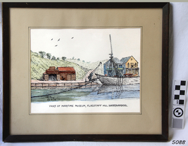 Flagstaff Hill Maritime Museum and Village
Painting - Watercolour, Alfred A Perry, Part of Maritime Museum, Flagstaff Hill. Warrnambool, 22-09-1979
This watercolour painting depicts a scene at Flagstaff Hill Maritime Village, showing some of the buildings and one of the vessels in the lake. The artist, Alfred A. Perry, lived in Victoria at the time of creating this painting. This painting is significant for its association with Flagstaff Hill Maritime Village. It shows a point in time, September 22nd, 1979, at which time the Ship's Chandler store was on the north of the lake. In 2022 the Ship's Chandler' is on the south of the lake and has been there for many years..Painting behind glass, framed in wood, black outline with watercolour. Depicting a scene of vessel at anchor on water, crane on wharf, buildings on track, valley and hills in background. Location is Flagstaff Hill Maritime Village. Artist is Alf Perry, painting dated 22-9-79.Signed "Alf Perry / 22-9-79" Handwritten on reverse "Alfred. A. Perry / 31 Vera St. / Bulleen / 850-3367"flagstaff hill, warrnambool, shipwrecked-coast, flagstaff-hill, flagstaff-hill-maritime-museum, maritime-museum, shipwreck-coast, flagstaff-hill-maritime-village, alf perry, watercolour, alfred perry, alfred a perry, flagstaff hill history, 1979, flagstaff hill village -
Federation University Historical Collection
Drawing - Rubbing, Rubbing on a plaque relating to the Sky High Restaurant
This is thought to be the work of Keith Rash of Ballarat.A number of rubbings from plaques on buildings. .1) Sky High Restaurant .2) Pioneers Tablet (Probably relating to the Pioneers Plot at the Ballaarat Old Cemetery. .3) and .4) Plaque relating to the Pioneers tablet.1) This Skyhigh restaurant was officially opened by The Hon. Vance Dickie M.L.C. Minister for Tourism on the 25th March 1971 This building was planned and constructed for The Ministry of Tourism J. Dale Fisher F.R.A.I.A. Architect W.J. Cody & Quinn Pty Ltd Builders .2) (logo) This tablet was erected by the citizens of Ballarat in honour of the pioneers of this city and district. .3) This MEMORIAL TABLET was unveiled on the 3rd May 1961 by F.W. WRAY, Esq in the company of S.C. HENDERSON, Esq. The only remaining members of the Original Pioneers Memorial Committee.architecture, j. dale, w, j, cody & quinn, skyhigh restaurant, frottage, rubbing, ballarat pioneers, keith rash -
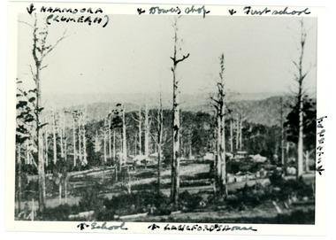 Mt Dandenong & District Historical Society Inc.
Photograph
Iconic photograph taken by Edgar Dower on Ridge Road in 1913 from an area known as Point Clear that shows the buildings of early Mt Dandenong before the CRB road went through in the 1920s.Black and white photograph with tall, dead trees in foreground and a view of hills in the distance. Buildings can be seen across the centre of the photograph. There are handwritten annotations around the border with arrows referring to areas in the photograph. Reverse of photograph has handwritten description by John Lundy-Clarke.Front from top left: Namoora (Lumeah), Dower's Shop, First school, Talent's, Langford's house, School. Reverse: 1913 view from O'Halloran's LOT 4, Section 3 on Ridge Road. Showing Lumeah (Namoora) Farndons Road (fence) School, Lowes House?, Falls Road Shop (Dowers) Langford's Falls Road (LOT 9, Section 1) Shed on Colomb's LOT 19, Sect 2 Colomb's House (Fergusons) First school Campbell's Blythes Road Lil Badenhop's P.O. In middle distance - Talent's homestead and sheds.point clear, namoora, lumeah, langford, dower, talent, colomb, ferguson, campbell, farndons road, mt dandenong school -
 Lakes Entrance Regional Historical Society (operating as Lakes Entrance History Centre & Museum)
Photograph, 1999
Building reputed to be part of Mrs Carstairs Boarding House at New Works, dismantled and transported to present site.Colour photograph of a timber dwelling at 12 Hunter Street. With hip roof across building, gable at right angles at western.front room. Iron roof, bull nose veranda. Simple timber fringe under veranda roof, timber brackets connect fringe to square veranda posts with lathed pattern in centre. Lakes Entrance Victoriahouses, heritage study -
University of Melbourne, Burnley Campus Archives
Plan - Photocopy, Percy Everett, New School of Primary Agriculture & Horticulture - Burnley Gardens, 1945
Floor plans and elevations of new building designed by Percy Everett, Chief Architect, Public Works DepartmentPhotocopies, reduced in size, of Original Plans for the Administrative Building. Signed, Percy Everett, Chief Architect, Dept of Public Works, Victoria, dated 26.09.1945 (1) UCB.2.135 Ground Floor and First Floor. (2) UCB.2.136 Transverse Section, Longitudinal Section. N.B. University of Melbourne - Property and Services has a better copy.buildings, percy everett -
 Bendigo Historical Society Inc.
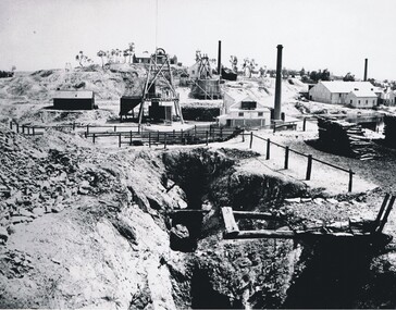
Photograph - VICTORIA HILL, 1860's ?
Black and white photo - mines and mining. At centre front - deep trench. At centre shed, poppet legs, wood pile, building with chimney at right. Wood pile, Building with chimney at back. At back, poppet legs on horizon, trees, building ( house ) buildings with chimney, trees, behind trees large 2 storey building ( Gold Mines Hotel ? ) other large buildings on horizon to right. ' Mining - Bendigo Vic. View of Victoria Hill taken from Old Chum Hill' written on back of photo.place, landscape view, victoria hill -
 Kew Historical Society Inc
Photograph - Kew Railway Station, Eva Grant, 1959
Eva Grant's three photograph albums, from which this individual photograph has been taken, contain important images of historic buildings in Kew, Victoria and Australia during the 1950s to the 1970s. The annotations in the album establish their date and provenance. Small black and white photograph of the Kew Railway Station in 1959. The photograph was taken by Kew Historical Society member Ms Eva Grant and placed in one of her scrapbooks (Historic Buildings, Kew, 1958-78). The photograph is from page 2."THE LAST PHASE. JAN 1959. KEW RAILWAY STATION"kew railway station -
 Glenelg Shire Council Cultural Collection
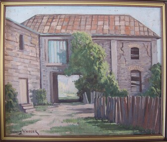
Painting, Greenmont from rear, c. 1955
Portland Town Council (?)Painting of a bluestone building with a shingle roof. In foreground right is a wooden fence. A carriageway cuts through centre of building, and above this is a window filled in with corrugated iron. The right side of building has large cracks. A tree is growing against the building in image centre, and bushes at image left and right. Framed in wooden frame.Front: Travis Webber (brown paint, lower left) Back: Geelong Picture Framers, 211 Moorabool Street, Gelong. Ph: 97805 (blue ink stamp, lower centre).oil painting, greenmont, portland town council