Showing 1592 items
matching looking south
-
 Kew Historical Society Inc
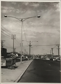
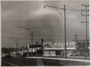
Photograph, Stuart Tompkins Studio, Electricity Supply Poles, South Road, Moorabbin, 1965
Research provided by Stuart Tompkins Studio, Box Hill, into alternatives for median strip street lighting to be used in Burke Road, Kew. The photographers identified variants in different suburbs appropriate to Kew's needs.The series from which the photograph is drawn provides a snapshot by a commercial photographic studio of each named vicinity in 1965 as well as providing examples of public works infrastructure being commissioned by local government in the 1960s. The photos originally formed part of the Engineering Department's files in the City of Kew before being donated to the kew Historical Society.Electricity Supply Poles, South Road, Moorabbin, 1965. Stuart Tompkins Studio provided this photograph for the Kew City Council. The photograph of South Road, Moorabbin, west of Jasper Road, looking east depicts steel poles with two lamps in a median strip and supply wires from pole to pole. The poles were described as 100′ apart. The notation on the rear of the photograph was that there were lamps along the median strip except at intersections. A wooden pole is recognised as supporting heavy supply lines across the road. The steel poles in the photograph were said to be between 3′ to 3.5′ whereas the wooden poles were three to 12.25″ in diameter. [There are three copies of this photograph in the Collection.] Typed inscription on reverse: "Electricity Supply Poles. Photographed for Kew City Council 8/2/65. No.2 South Road - Moorabbin, west of Jasper Road, looking east. Steel poles with two lamps in median strip and supply wires from pole to pole along median strip (poles only 100' apart). Lamps along median only except at intersections. Wooden pole supports heavy supply lines across the road. Wooden poles 3' up and 8 1/2" dia. Wooden poles 3' up and 12 1/2 dia." Studio stamp: "Stuart Tompkins Studio. 547 Station Street, Box Hill. WX1439."stuart tompkins studio, street lighting, south road (moorabin) 1965, public infrastructure -- city of kew, city of kew -- engineer's department -
 Kew Historical Society Inc
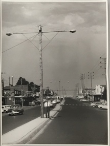
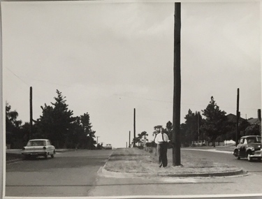
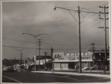
Photograph, Stuart Tompkins Studio, Electricity Supply Poles, North Road, Ormond, 1965
Research provided by Stuart Tompkins Studio, Box Hill, into alternatives for median strip street lighting to be used in Burke Road, Kew. The photographers identified variants in different suburbs appropriate to Kew's needs.The series from which the photograph is drawn provides a snapshot by a commercial photographic studio of each named vicinity in 1965 as well as providing examples of public works infrastructure being commissioned by local government in the 1960s. The photos originally formed part of the Engineering Department's files in the City of Kew before being donated to the kew Historical Society.Electricity Supply Poles, North Road, Ormond, 1965. Electricity supply poles photographed for the Kew City Council by Stuart Tompkins Studio. The photograph of North Road, Ormond west of Jasper Road, looking east depicts wooden poles carrying two lamps in a median strip and with two on each side alternately. It was noted that the supply wires were from one side only. The poles were described as 3′ above ground and 11.25″ in diameter. The plan was to use this approach for Burke Road, Kew. [There are three copies of this photograph in the Collection.] Typed inscription on reverse: "Electricity Supply Poles. Photographed for Kew City Council 8/2/65. No.1 North Road - Ormond, west of Jasper Road, looking east. Wooden poles carrying two lamps in median strip and two on each side alternately just as is proposed for Burke Road, Kew. Supply wires from one side only. Poles 3' above ground 11 1/4" dia." Studio stamp: "Stuart Tompkins Studio. 547 Station Street, Box Hill. WX1439."stuart tompkins studio, street lighting, south road (moorabin) 1965, public infrastructure -- city of kew, city of kew -- engineer's department -
 Kew Historical Society Inc
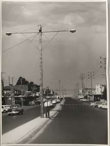
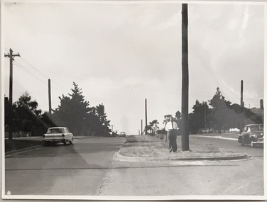
Photograph, Stuart Tompkins Studio, Electricity Supply Poles, North Road, Ormond, 1965
Research provided by Stuart Tompkins Studio, Box Hill, into alternatives for median strip street lighting to be used in Burke Road, Kew. The photographers identified variants in different suburbs appropriate to Kew's needs.The series from which the photograph is drawn provides a snapshot by a commercial photographic studio of each named vicinity in 1965 as well as providing examples of public works infrastructure being commissioned by local government in the 1960s. The photos originally formed part of the Engineering Department's files in the City of Kew before being donated to the kew Historical Society.Electricity Supply Poles, North Road, Ormond, 1965. Electricity supply poles photographed for the Kew City Council by Stuart Tompkins Studio. The photograph of North Road, Ormond west of Jasper Road, looking east depicts wooden poles carrying two lamps in a median strip and with two on each side alternately. It was noted that the supply wires were from one side only. The poles were described as 3′ above ground and 11.25″ in diameter. The plan was to use this approach for Burke Road, Kew. [There are three copies of this photograph in the Collection.] Typed inscription on reverse: "Electricity Supply Poles. Photographed for Kew City Council 8/2/65. No.1 North Road - Ormond, west of Jasper Road, looking east. Wooden poles carrying two lamps in median strip and two on each side alternately just as is proposed for Burke Road, Kew. Supply wires from one side only. Poles 3' above ground 11 1/4" dia." Studio stamp: "Stuart Tompkins Studio. 547 Station Street, Box Hill. WX1439."stuart tompkins studio, street lighting, south road (moorabin) 1965 -
 Kew Historical Society Inc
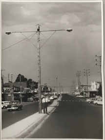
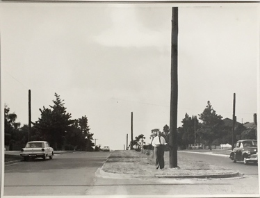
Photograph, Stuart Tompkins Studio, Electricity Supply Poles, North Road, Ormond, 1965
Research provided by Stuart Tompkins Studio, Box Hill, into alternatives for median strip street lighting to be used in Burke Road, Kew. The photographers identified variants in different suburbs appropriate to Kew's needs.The series from which the photograph is drawn provides a snapshot by a commercial photographic studio of each named vicinity in 1965 as well as providing examples of public works infrastructure being commissioned by local government in the 1960s. The photos originally formed part of the Engineering Department's files in the City of Kew before being donated to the kew Historical Society.Electricity Supply Poles, North Road, Ormond, 1965. Electricity supply poles photographed for the Kew City Council by Stuart Tompkins Studio. The photograph of North Road, Ormond west of Jasper Road, looking east depicts wooden poles carrying two lamps in a median strip and with two on each side alternately. It was noted that the supply wires were from one side only. The poles were described as 3′ above ground and 11.25″ in diameter. The plan was to use this approach for Burke Road, Kew. [There are three copies of this photograph in the Collection.] Typed inscription on reverse: "Electricity Supply Poles. Photographed for Kew City Council 8/2/65. No.1 North Road - Ormond, west of Jasper Road, looking east. Wooden poles carrying two lamps in median strip and two on each side alternately just as is proposed for Burke Road, Kew. Supply wires from one side only. Poles 3' above ground 11 1/4" dia." Studio stamp: "Stuart Tompkins Studio. 547 Station Street, Box Hill. WX1439."stuart tompkins studio, street lighting, south road (moorabin) 1965 -
 Kew Historical Society Inc
Photograph, Stuart Tompkins Studio, Electricity Supply Poles, Burke Road, Kew, 1965
Research provided by Stuart Tompkins Studio, Box Hill, into alternatives for median strip street lighting to be used in Burke Road, Kew. The photographers identified variants in different suburbs appropriate to Kew's needs.The series from which the photograph is drawn provides a snapshot by a commercial photographic studio of each named vicinity in 1965 as well as providing examples of public works infrastructure being commissioned by local government in the 1960s. The photos originally formed part of the Engineering Department's files in the City of Kew before being donated to the kew Historical Society.Electricity Supply Poles, Burke Road, Kew, 1965. This photograph of Burke Road, Kew was taken just north of Kilby and Doncaster Roads looking north. Stuart Tompkins Studio provided the photograph for the Kew City Council. In the photograph are a number of electricity supply poles that have been erected in the median strip, in addition to some new poles on each footpath. The nearest wooden pole is stated to be 13.5″ in diameter. The electricity poles in Burke Road required Kew Council to investigate comparable designs in other Melbourne municipalities. [There are three copies of this photograph in the Collection.] Typed inscription on reverse: "Electricity Supply Poles. Photographed for Kew City Council 8/2/65. No.5 Burke Road - Kew, just north of Kilby and Doncaster Roads looking north. Some of seven poles already erected in median strip. Shows also some new poles erected on each footpath. Nearest wooden pole 13 1/2" dia." Studio stamp: "Stuart Tompkins Studio. 547 Station Street, Box Hill. WX1439."stuart tompkins studio, street lighting, south road (moorabin) 1965 -
 Kew Historical Society Inc
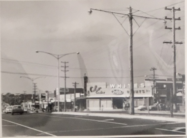
Photograph, Stuart Tompkins Studio, Electricity Supply Poles, Warrigal Road, Ashwood, 1965
Research provided by Stuart Tompkins Studio, Box Hill, into alternatives for median strip street lighting to be used in Burke Road, Kew. The photographers identified variants in different suburbs appropriate to Kew's needs.The series from which the photograph is drawn provides a snapshot by a commercial photographic studio of each named vicinity in 1965 as well as providing examples of public works infrastructure being commissioned by local government in the 1960s. The photos originally formed part of the Engineering Department's files in the City of Kew before being donated to the kew Historical Society.Electricity Supply Poles, Warrigal Road, Ashwood, 1965. Stuart Tompkins Studio provided this photograph for the Kew City Council. The photograph, taken at the intersection of Warrigal Road and High Street South, Ashwood looks north along High Street Road. The intent of the photograph was to provide the Council with models of electricity supply poles. In the photo, wooden and steel poles can be seen in the median strip. The photograph also includes the shops bordering High Street Road during this period. [There are three copies of this photograph in the Collection.]. Typed inscription on reverse: "Electricity Supply Poles. Photographed for Kew City Council 8/2/65. No.4 Warrigal Road - Ashwood. South of High Street Road looking north. Wooden and steel poles with different brackets in median strip." Studio stamp: "Stuart Tompkins Studio. 547 Station Street, Box Hill. WX1439."electric light poles, public works -- 1960s, civic infrastructure -- 1960s -
 Kew Historical Society Inc
Photograph, Stuart Tompkins Studio, Electricity Supply Poles, Warrigal Road, Ashwood, 1965
Research provided by Stuart Tompkins Studio, Box Hill, into alternatives for median strip street lighting to be used in Burke Road, Kew. The photographers identified variants in different suburbs appropriate to Kew's needs.The series from which the photograph is drawn provides a snapshot by a commercial photographic studio of each named vicinity in 1965 as well as providing examples of public works infrastructure being commissioned by local government in the 1960s. The photos originally formed part of the Engineering Department's files in the City of Kew before being donated to the kew Historical Society.Electricity Supply Poles, Warrigal Road, Ashwood, 1965. Stuart Tompkins Studio provided this photograph for the Kew City Council. The photograph, taken at the intersection of Warrigal Road and High Street South, Ashwood looks north along High Street Road. The intent of the photograph was to provide the Council with models of electricity supply poles. In the photo, wooden and steel poles can be seen in the median strip. The photograph also includes the shops bordering High Street Road during this period. [There are three copies of this photograph in the Collection.]. Typed inscription on reverse: "Electricity Supply Poles. Photographed for Kew City Council 8/2/65. No.4 Warrigal Road - Ashwood. South of High Street Road looking north. Wooden and steel poles with different brackets in median strip." Studio stamp: "Stuart Tompkins Studio. 547 Station Street, Box Hill. WX1439."electric light poles, civic infrastructure - 1960s, public works -- 1960s -
 Kew Historical Society Inc
Photograph, Stuart Tompkins Studio, Electricity Supply Poles, Warrigal Road, Ashwood, 1965
Research provided by Stuart Tompkins Studio, Box Hill, into alternatives for median strip street lighting to be used in Burke Road, Kew. The photographers identified variants in different suburbs appropriate to Kew's needs.The series from which the photograph is drawn provides a snapshot by a commercial photographic studio of each named vicinity in 1965 as well as providing examples of public works infrastructure being commissioned by local government in the 1960s. The photos originally formed part of the Engineering Department's files in the City of Kew before being donated to the kew Historical Society.Electricity Supply Poles, Warrigal Road, Ashwood, 1965. Stuart Tompkins Studio provided this photograph for the Kew City Council. The photograph, taken at the intersection of Warrigal Road and High Street South, Ashwood looks north along High Street Road. The intent of the photograph was to provide the Council with models of electricity supply poles. In the photo, wooden and steel poles can be seen in the median strip. The photograph also includes the shops bordering High Street Road during this period. [There are three copies of this photograph in the Collection.]. Typed inscription on reverse: "Electricity Supply Poles. Photographed for Kew City Council 8/2/65. No.4 Warrigal Road - Ashwood. South of High Street Road looking north. Wooden and steel poles with different brackets in median strip." Studio stamp: "Stuart Tompkins Studio. 547 Station Street, Box Hill. WX1439."electric light poles, public infrastructure -- 1960s, civic works -- 1960s -
 Kew Historical Society Inc
Photograph - Flooding of the Yarra Valley at Kew East, 1974
Flooding of the Yarra Valley, including that section of the Yarra bordering Kew and Kew East in the north and west of the municipality, was a regular occurrence. Extreme flood events of the Yarra River are recorded to have occurred in 1891, 1901, 1916, 1923 and 1934. The Municipality of Kew's response to these floods was to enact planning decisions restricting residential development in flood prone areas following the floods of 1916, 1921 and 1934. While floods continued after the development of the Upper Yarra Reservoir (construction 1948-57), the regularity and extent of these inundations diminished. During the nineteenth century, the land abutting the south side of the Yarra in Kew was devoted to dairy farming. In the twentieth century, before and after the construction of the Eastern Freeway, much of this low-lying area was used as golf courses and public parks.Late example of the capacity of the Yarra Valley at Kew to flood, even though drainage works and the Upper Yarra Reservoir had reduced their regularity.Original black and white print photograph of the low-lying land at East Kew under floodwater on 16 May 1974. The vantage point of the photographer is Lister Street. Flooding was caused by overflowing water in Glass' Creek and the River Yarra. Annotation verso: "Lister Street looking north / Flood level / 16 May 1974 11.30am / R.L. 46.04"hays paddock, floods, yarra river, glass' creek, lister street -
 Kew Historical Society Inc
Photograph - Flooding of the Yarra Valley at Kew East, 1974
Flooding of the Yarra Valley, including that section of the Yarra bordering Kew and Kew East in the north and west of the municipality, was a regular occurrence. Extreme flood events of the Yarra River are recorded to have occurred in 1891, 1901, 1916, 1923 and 1934. The Municipality of Kew's response to these floods was to enact planning decisions restricting residential development in flood prone areas following the floods of 1916, 1921 and 1934. While floods continued after the development of the Upper Yarra Reservoir (construction 1948-57), the regularity and extent of these inundations diminished. During the nineteenth century, the land abutting the south side of the Yarra in Kew was devoted to dairy farming. In the twentieth century, before and after the construction of the Eastern Freeway, much of this low-lying area was used as golf courses and public parks.Late example of the capacity of the Yarra Valley at Kew to flood, even though drainage works and the Upper Yarra Reservoir had reduced their regularity.Original black and white print photograph of Hay's Paddock under floodwater on 16 May 1974. The vantage point of the photographer is Keystone Crescent looking east. Flooding was caused by overflowing water in Glass' Creek and the River Yarra. Annotation verso: "Keystone Cr looking east / 16 May 1974 11.50am"hays paddock, floods, yarra river, glass' creek -
 Kew Historical Society Inc
Photograph - Flooding of the Yarra Valley at Kew East, 1974
Flooding of the Yarra Valley, including that section of the Yarra bordering Kew and Kew East in the north and west of the municipality, was a regular occurrence. Extreme flood events of the Yarra River are recorded to have occurred in 1891, 1901, 1916, 1923 and 1934. The Municipality of Kew's response to these floods was to enact planning decisions restricting residential development in flood prone areas following the floods of 1916, 1921 and 1934. While floods continued after the development of the Upper Yarra Reservoir (construction 1948-57), the regularity and extent of these inundations diminished. During the nineteenth century, the land abutting the south side of the Yarra in Kew was devoted to dairy farming. In the twentieth century, before and after the construction of the Eastern Freeway, much of this low-lying area was used as golf courses and public parks.Late example of the capacity of the Yarra Valley at Kew to flood, even though drainage works and the Upper Yarra Reservoir had reduced their regularity.Original black and white print photograph of the low-lying land at East Kew under floodwater on 16 May 1974. The vantage point of the photographer is Lister Street. Flooding was caused by overflowing water in Glass' Creek and the River Yarra. Annotation verso: "Lister St looking same as No.3 / 16 May 1974 11.30"floods, yarra river, glass' creek, lister street -
 Kew Historical Society Inc
Photograph - Flooding of the Yarra Valley at Kew East, 1974
Flooding of the Yarra Valley, including that section of the Yarra bordering Kew and Kew East in the north and west of the municipality, was a regular occurrence. Extreme flood events of the Yarra River are recorded to have occurred in 1891, 1901, 1916, 1923 and 1934. The Municipality of Kew's response to these floods was to enact planning decisions restricting residential development in flood prone areas following the floods of 1916, 1921 and 1934. While floods continued after the development of the Upper Yarra Reservoir (construction 1948-57), the regularity and extent of these inundations diminished. During the nineteenth century, the land abutting the south side of the Yarra in Kew was devoted to dairy farming. In the twentieth century, before and after the construction of the Eastern Freeway, much of this low-lying area was used as golf courses and public parks.Late example of the capacity of the Yarra Valley at Kew to flood, even though drainage works and the Upper Yarra Reservoir had reduced their regularity.Original black and white print photograph of the low-lying land at East Kew under floodwater on 16 May 1974. The photograph is of Hyde Park looking north-east.Annotation verso: "Hyde Park looking nth-east / Flood Level / 16 May 1974 11.15am / R.L. 46.61"floods, yarra river, hyde park -
 Queen Victoria Women's Centre
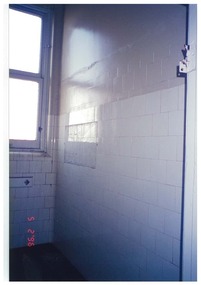
Photograph, 5 February 1996
... Colour photograph. Level one south eastern corridor looking.... Level one south eastern corridor looking into where in 2015 ...Colour photograph. Level one south eastern corridor looking into where in 2015 is a doorway at the wall and where is the archive room. Taken during restoration inspection.historic buildings, building construction -
 Queen Victoria Women's Centre
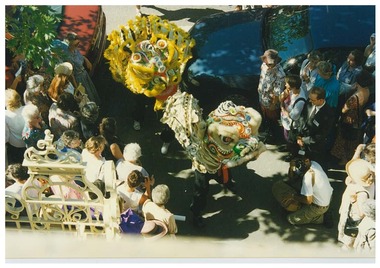
Photograph, 15th or 16th February 1997
Colour photograph. Official opening weekend 'The Young Lions' young female members of the Chinese youth society of Melbourne (17-20 years old) The dance is to frighten away evil spirits with noise, provided by drums and to bring good luck. Taken from south balcony on level 1 looking down to the front steps. official events, historic buildings, cultural structures and establishments, chinese community -
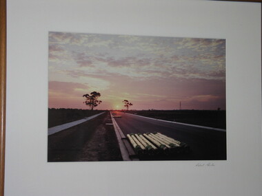 Brimbank City Council Art Collection
Photograph, Robert Pointon, Industrial Drive Facing West in South Sunshine, 1990
Local sceneLocal sceneColour Photograph - looking down a road at sunset - stacked pipes in foreground. Made as a series of three plates - AR0009 -
 Stawell Historical Society Inc
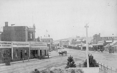
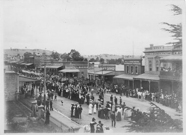
Photograph, Main Street Stawell looking East from the Present War Memorial site 1878
Main St. looking East towards Big Hill from Coffee Palace Verandah over Present War Memorial area. 1878 Businesses from left Walters and Son Factory, General Furnishing Mart, Stawell Town Hall, J. & A. Price Wine Spirits & Provision Merchants, Stawell Post Office. On right south side of Main Street, two-storey wooden Bull & Mouth Hotel, Whiteside Taylors, Carters Boot shop, Lecky Draper, C. Mulcahy Post Office Hotel, G.J. Hewlett Baker & Confectionery, Iron Monger, Victoria House Bond Draper, Town Hall Hotel, J. Richards Fancy Repository. Victorian Views. C. Herbert, Photo. Stawell 1878stawell business streetscape -
 Stawell Historical Society Inc
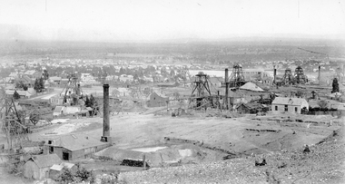
Photograph, Panorama Of Stawell from Big Hill looking North West 1878 Mines Visible
On very left behind the winding engine shed in the foreground is the South Cross Mines No8 & No9. The next mine to the right not counting the Whims is the Crown Cross United Mine with curved tramway. Tyne Reefing Company is barely visible at centre of image in front of left end of settling dam. The Great Northern is centre right of image, Extended Cross Reef Mine, then Oriental Mine, the Grant Lamont Battery and two Pleasant Creek Cross Reef Poppet Heads.Scotchmans United Quarts Mining Company 1878Victorian Views. C. Herbert, Photo. Stawell 1878stawell mining -
 Stawell Historical Society Inc
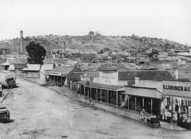
Photograph, Streetscape of South side of Upper Main Street Reefs Stawell looking East from around Patrick Street corner with Big Hill Mining in background c 1867
Upper Main Street east of Patrick street, looking East c 1867 with Big Hill Mining in Background. J McGee's Shamrock Hotel. Jennings Western Turf Hotel. R Lorimer & Co. Photo c 1867 McGees Shamrock Hotel centre. R. Williams Dining Rooms, Jennings's Western Turf Hotel. Situated in upper Main Street (Opposite Monaghan's Estate Office) Mr. George Jennings was proprietor until the late 1860's when he went to live at "Mayo Park" Lubek. The Hotel had Various owners until it was delicensed in 1909 and became a boarding house. It was demolished in 1921. R. Lorimer & Co general Store near corner of Patrick Street.Streetscape of South Side of Main Street East of Patrick Street. Two wagons in street. Showing J. McGees Shamrock Hotel, R Williams Dining Rooms, Jennings's Western Turf Hotel and R. Lorimer & Co. Mine Engine Chimney is on left of photo. Big Hill in Background with Waterloo Reef Company Whim at centre.stawell streetscape -
 Stawell Historical Society Inc
Photograph, Lower Main Street Stawell procession, probably Easter c1900 or 1906 showing a Chinese dragon
Main Street Procession c1900 in front of Methodist Church looking East. Constable on Horseback visible. Possibly the Ballarat dragon making the date 1906 or it could be the Chinese See Yup Society Dragon, the head of which is still preserved in their South Melbourne temple. Businesses from left, Carters Boot Shop, Post Office Hotel, G. Mahanke Bakery, J.H. Stabb Stawell Coach Factory, Speedwell Cycles, W.J. Jenkinson Bootmakers, Bone Saddle & Harness Factory, W. Whiteside Taylors. Big Hill is visible in background and possibly the Market Building roof above the G. Mahnke sign. Sop In Trove the only mentions of a Chinese parade at Stawell was for Easter Monday 1906, and this occasion did feature a dragon – the costumes, banners, and dragon appear to have been borrowed from Melbourne, and it is suspected that this was the See Yup Society Dragon, the head of which is still preserved in their South Melbourne temple. At the time that this photo was taken there were only three Chinese communities in Victoria which are now known to have had parade regalia and a dragon – Bendigo, Ballarat, and Melbourne. The Melbourne dragon was the smaller of these, and that seems to match with what you can see in the photo, as does what appears to be a striped horn (frustratingly the pole obscures most of the dragon’s face). All three dragon heads still survive today, as does some of the original parade regalia, but Bendigo’s collection and dragon is the most complete. The remains of the See Yup Society collection have still to be properly studied and conserved. I would also note that if this photo was from Easter Monday 1906 then Bendigo and possibly Ballarat Chinese communities would not have been able to make their dragons available as both would have been preoccupied with their own towns’ Easter festivities. Photo taken from the Town Hall balcony of procession looking towards corner of Wimmera Street stawell businesses streetscape, chinese -
 Maldon Vintage Machinery Museum Inc
Steam Engine, Estimated late 19th century
Large 4 wheeled single cylinder (horizontal) steam engine designed to be towed. Fire box painted black, boiler and steam cylinder green, wheels red. Boiler is not sound so engine is connected to an independent steam/air source to be operated for display purposes. 150 cm flywheel on LHS looking forward toward the front. Brass water drain tap on firebox. Also other brass fittings on firebox. Cast brass disc with red background fixed high on firebox :- "Marshal Sons & Co. / Made expressly / to the order / Shut, No. 45781, Open / of / Robison Bros / South Melbourne." "10017" raised in relief on firebox door. machinery; engines; steam power source -
 National Wool Museum
Throw, 2017
Anlaby’s sheep are born, bred and shorn at their farm located in South Australia. The wool is then scoured at Michels in Adelaide, combed and turned into Tops at Cashmere Connections in Bacchus Marsh, and then Spun and Woven at a historic mill in Scotland named Johnstons of Elgin. Sewing is completed by artisan seamstresses and packaging is from a local Adelaide family business. Established in 1839 just North of the Barossa Valley in South Australia, Anlaby is the oldest continuing merino sheep stud on mainland Australia. Fredrick Dutton employed Alexander Buchannan to bring sheep to the buoyant market in Adelaide from Goulburn NSW. Several others speculated on possible successes, including Buchannan and a flock of 18,000 sheep were walked overland. The trek took nine months. During this time the Adelaide market prices had collapsed. Having found land with a spring of sweet water, Dutton decided to keep his flock of 5,000 stud sheep and purchased a small parcel of land that is now called Anlaby. The property prospered and Buchannan was employed as manager for the next 25 years. At its height Anlaby covered 250sq miles – 160,000 acres and employed 70 men. The first bale of wool from South Australia to be auctioned in London came from Anlaby. The Anlaby stud also provided the foundation ewes for the well-known Bungaree merino stud in 1841. With prosperity came a large house and gardens for Buchannan in 1861. Anlaby was inherited by Henry Dutton from his uncle in 1895. Squire Dutton, as he was known, continued to grow the family’s fortunes and spent his money expanding the grand home and creating a magnificent 10-acre garden. Today the Anlaby merino stud continues and both the house and garden are undergoing significant restorations. Wool continues to be one of the most important elements at Anlaby. It was the source of great wealth in the past and is now directly tied into Anlaby’s future. Anlaby makes beautiful woollen scarves, lady’s wraps, exquisite throws and small range of baby blankets. From the moment a lamb is conceived and through its entire lifecycle Anlaby look after nutrition and quality of life. Twice a year the sheep are shorn and the wool using minimal treatment is washed, combed, spun and woven into the Anlaby product range. This attention to detail results in the buttery softness distinctive of the exclusive woollen range.Throw came with packaging and information card which reads ANLABY in large capital lettering at the top and bottom of either side of card. Throw is white with green edging of 15cm on two edges. Within this edging is the sewing of a tree in white.Wording: ANLABY Pure Anlaby Merino Wool Oldest merino stud on mainland Australia Made in Australia Card. Wording: ANLABY Certificate of Authentication THIS CERTIFICATE AUTHENTICATES THE PRODUCT TO BE 100% AUSTRALIAN AND MADE FROM PURE MERINO WOOL PRODUCED EXCLUSIVELY AT THE ANLABY MERINO STUD IN SOUTH AUSTRALIA THE ANLABY FLOCK (REGISTERED NUMBER 102) IS THE OLDEST CONTINUOSLY OPERATING MERINO STUD IN MAINLAND AUSTRALIA. THE MERINO FLOCK AT ANLABY MAINTAINS A GENETIC LINE STARTED IN 1839 THIS PRODUCT IS PART OF THE LIMMITED EDITION RANGE PRODUCED AT ANLABY. IN 2014 WE CELEBRATED ANLABY’S 175TH ANNIVERSAY ANLABY Reverse. Wording: ANLABY PURE NATURAL WOOL THE SHEEP GRAZE AMONGST THE GUM TREES ON THE ROLLING HILLS OF ANLABY. ANLABY SHEEP ARE CHARACTERISTICALLY BIG BODDIED AND BRED TO FLOURISH IN THE WARM AUSTRALIAN CLIMATE. OUR WOOL IS MINIMALLY TREATED AND THE PRODUCTS ARE MADE IN SMALL RUNS UNDER THE PERSONAL SUPERVISION OF THE OWNERS. WE BELIEVE IN SUSTAINABLE AND RESPONSIBLE FARMING AND MILLING PRACTICES. THE ATTENTION TO DETAIL RESULTS IN THE BUTTERY SOFTNESS DISTINCTIVE OF THIS EXCLUSIVE WOOLLEN PRODUCT. WITH CARE THIS IS A TREASURED ITEM FOR THE NEXT GENERATION. ANLABY www.anlaby.com.auwool, merino sheep, south australia, wool processing, wool processing textile finishing -
 Vision Australia
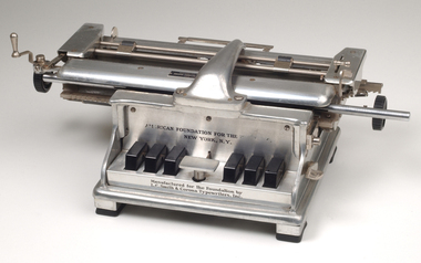
Functional object - Object, Foundation writer
The American Foundation for the Blind developed this new model in their experimental shop in 1932 and contracted with the typewriter manufacturer to produce the machines and continued production until 1947. It's sleek silver look was a change of look from the previously manufactured Hall Braille Writer, and improvements included a carriage return, the ability to add spaces between lines and a back space key. It was found in the Braille and Talking Book Library in South Yarra, Victoria, Australia and was used by either staff or volunteers at Vision Australia Library.Stainless steel braille writer in the shape of a typewriter. The braille writer consists of a heavy moulded machine with 6 black plastic keys.On front of writer: "American Foundation for the Blind Inc. New York." "Manufactured for the Foundation by L.C. Smith & Corona Typewriters, Inc." On back: "Licenced by Underwood Elliot Fisher company/ Serial no. 5-2422.braille equipment, assistive devices -
 Vision Australia
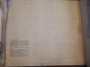
Plan - Image, Proposed additional nurses bedroom to "Myer Home" existing nursery, Blind Institute, St Kilda Rd, 23/8/1949
In 1949 an architect produced this plan to detail the addition of a bedroom for the nursing staff, who looked after children in the Blind Babies nursery. The plan shows a layout of the RVIB site, including the 'Myers Home' (the name of the nursery) where young children were cared for. The south and eastern elevations are detailed, as well as a plan of the nursery, which had 4 bedrooms, a living room, a dinning room , bathroom, 2 kitchen areas and the proposed additional nurses bedroom next to Bedroom 4.1 architectural plan of Myer House and proposed extensionPercy E Everett, Chief Architectroyal victorian institute for the blind, rvib nursery, plans, myer house -
 Port Fairy Historical Society Museum and Archives
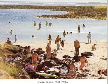
Photograph - Postcard, South Beach Port Fairy
... Colour photographic postcard South Beach Port Fairy... postcard South Beach Port Fairy, Looking West South Beach Port ...Colour photographic postcard South Beach Port Fairy, Looking WestSouth Beach Port Fairysouvenir, port-fairy, post card, south beach, pea soup -
 Port Fairy Historical Society Museum and Archives
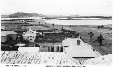
Postcard - Post Card, Looking towards the island Port Fairy
Looking towards the island Port Fairyblack and white photograph taken from the mill looking towards Griffith Island.town, townscape, river, griffith island, south west passage, causeway bridge, span bridge, ocean, sea, wetland -
 Port Fairy Historical Society Museum and Archives
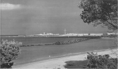
Photograph
East Beach south east cornerBlack and white photograph of East Beach near Battery Hill looking toward Griffith Island lighthouse in backgroundeast beach, battery hill, training walls, lighthouse, lighthouse keepers cottages, flagstaff -
 Port Fairy Historical Society Museum and Archives
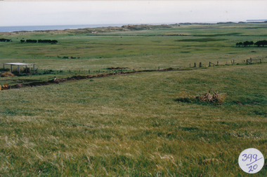
Photograph
... Coloured photograph of Hills above South Beach Estate... above South Beach Estate looking to sea Photograph Photograph ...South Beach DevelopmentColoured photograph of Hills above South Beach Estate looking to seasouth beach, development, west, farmland -
 Port Fairy Historical Society Museum and Archives
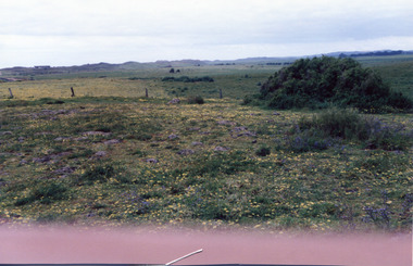
Photograph
South Beach Developement Coloured photograph of Rocky outcrop looking towards dunessouth beach, development, bluestone, west