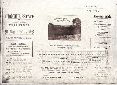
Showing 11608 items matching "surveyor-general"
-
 Warrnambool and District Historical Society Inc.
Letter book 5, 1910
This letter book has letters, invoices and sketch maps and dates from 1910 to 1914. It came from the office of John William Crawley, Junior, an engineer, surveyor and architect in private practice in Warrnambool and also the official engineer for the Shire of Warrnambool from 1895 to 1935. His father, brother and son were also engineers and worked in that capacity or as the Shire Secretary for the Shire of Warrnambool, with the Crawley family recording a total of 132 years of service to the Shire. The letter book was passed on to John Crawley’s son, Rolf, engineer for the Shire of Warrnambool from 1935 to 1968. The letter book then came into the possession of Michael Hand who took over the private surveying business of Rolf Crawley in Warrnambool and the Warrnambool and District Historical Society has acquired the letter book, one of several Crawley ledgers, from the estate of Michael Hand.This letter book is of considerable significance as it contains maps, plans, sketches and written information, the work of John William Crawley, Junior, the Shire of Warrnambool engineer for 40 years. It will be very useful for research purposes. This is a brown-covered letter book of 750 pages with a mottled blue inside lining. The pages contain an alphabetical index and copies of handwritten letters and sketch maps and plans. There is one loose letter dated 1937. The pages are somewhat stained and the spine on the cover has been torn away. There is a mauve stamp on the first page. ‘5’ ‘Rolf L. Crawley, Civil Engineer, Drainage and Water Supply Engineer, Licensed Surveyor, Registered Architect, Warrnambool’ rolf crawley, warrnambool, john william crawley, junior, warrnambool -
 Whitehorse Historical Society Inc.
Document, Schwerkolt Cottage, 1965
Program for official opening of Schwerkolt CottageProgram for official opening of Schwerkolt Cottage by His Excellency Major General Sir Rohan Delacombe, 17 October 1965Program for official opening of Schwerkolt Cottageschwerkolt cottage, delacombe, rohan (sir), city of nunawading -
 Glenelg Shire Council Cultural Collection
Artwork, other - Engraving / Illustation, n.d
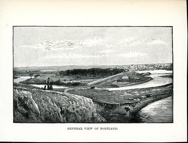
Illustration. Taken and cut from a book. Rectangular bordered image. Black and white. Cream coloured paper. View of Portland Victoria from Observatory Hill. A man in a waistcoat and a hat with dogs stands in the foreground on the edge of a large rising to the left of the image. a body of water snakes through the centre with a large patch of trees behind. In the distance a large cluster of dwelling of various sizes and shapes are visible to the right of the image. Printed underneath GENERAL VIEW OF PORTLAND. Front: 'GENERAL VIEW OF PORTLAND' - printed, lower frame.city of portland -
Port Melbourne Historical & Preservation Society
Plan - Verandah, Shipping Office, Town Pier, Sandridge, 8 Jan 1862
Plan of verandah to shipping office, Town Pier, Sandridge, 1862.Fred. W. Bull (Municipal Surveyor)piers and wharves - town pier, frederick william bull -
University of Melbourne, Burnley Campus Archives
Plan - Photocopy, Proposed Reserve for Horticultural and Experimental Garden in the Survey Paddock Richmond, 1862-1948
Photocopy of Plan Gazetted 01.08.1863. From Central Plan Office Department of Natural Resources.Original signed by Clement Hodgkinson, Deputy Surveyor General. Stamped Department of Lands and Survey 7.12.48 Neg.18377. Handwritten notes on back "Melb Roll 23, R.19(A)"burnley, horticultural and experimental garden, survey paddock, richmond, clement hodgkinson -
 Chiltern Athenaeum Trust
Brass Buttons : Post Master General (Australia), 1901
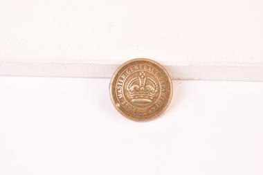
Used for uniforms at the initial establishment of the Post Master Generals Department (Australia) 1901. Staff wore uniforms depicting they belong to the postal service. Used for uniforms in the initial establishment of the Post Master Generals Department circa 1901. round brass button with round ring attachment at reverse for affixing to clothing. Inscribed - Post Master Generals Department with an etched crown in he middle of the button. 1901 post master generals department, australia postal service -
 Tatura Irrigation & Wartime Camps Museum
Photograph, 1947
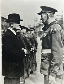
WO2 Woof meeting General Birdwood, on ANZAC Day 1947 in London. "Orontes" unable to disembark POW's in Cuxhaven, Germany because of the big Freeze.Black and white photograph of WO2 John Woof AIF meeting General Birdwood Anzac Day 1947.pow's, repatriated pow's, wo john woof, general birdwood, aif -
Glenelg Shire Council Cultural Collection
Plan - Plan - Portland, Victoria, n.d
Plan of Portland, compiled and drawn by T.E.C. Henry, Assistant Surveyor, Nov. 1893 -
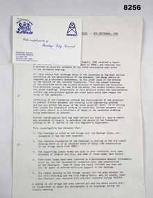 Bendigo Military Museum
Document - SURVEYORS RESTORATION REPORT BENDIGO, Bendigo City Council, c.1986
Surveyors report 1986 regarding the restoration of the Bendigo Cenotaph continued on from Cat No 8255. The document starts with a report to a Council meeting held on August 18th 1986. This is a more detailed report of the first by Dr. A.H. Spry (AMDEL) followed by Mr W. Barton City Engineers Department. The state of the Cenotaph was also compounded by it's situation re the Bendigo Creek. Main points where. The Cenotaph is sited on the Bridge over the Creek not alongside it as was supposed. The Cenotaph concrete foundation was resting on the old timber decking which is in an advanced state of decay among 5 main points. Report goes on with points. Conclusion; "It would of course be necessary to demolish the Cenotaph to carry out this work". Estimate of costs in brief. 1. Bridge repairs $72,000.00. 2. Cenotaph repairs. - Demolish & rebuild $110,000.00. Options - There are only two options (as per estimate) or demolish and relocate to another location under 3 sections (a) (b) (c). Recommendations; Motions referred to Estimates 1986/87 and RSL for comments - 1 carried, 1 lost.Document, paper 3 pages foolscap size, all print in black, copy of original, stapled with the pages is a Bendigo City Compliments Card in blue text.Main points, "Building Surveyors report - 8th September 1986 - B.18/86 - restoration of Cenotaph (32.7.1)"document, surveyor, cenotaph, brsl, smirsl -
 Warrnambool and District Historical Society Inc.
Documents, 1930s,40s,50s,60s
These documents came from the office of Rolf Crawley who was an engineer, surveyor and architect in private practice in Warrnambool and also the engineer for the Shire of Warrnambool from 1935 to 1968. His grandfather, father and uncle were also engineers, working in that capacity for the Shire of Warrnambool or as Secretary for the Shire of Warrnambool, with the Crawley family recording a total of 132 years of service to the Shire. The Shire of Warrnambool existed from 1863 to 1994. The documents came into the possession of Michael Hand who took over the Crawley surveying business in Warrnambool. The Warrnambool and District Historical Society acquired the documents, along with other Crawley memorabilia, from the Michael Hand Estate. These documents will be useful for reference and research, particularly in regard to the Shire of Warrnambool history.This is a packet of documents from the office of Rolf Crawley. They are mostly single sheets which include letters from the Office of the Surveyors Board, documents relating to employees and trainees and some Government papers. They are mostly typewritten with the signature of Rolf Crawley. There is one map of the Eumerella Drainage area.rolf crawley, warrnambool, shire of warrnambool -
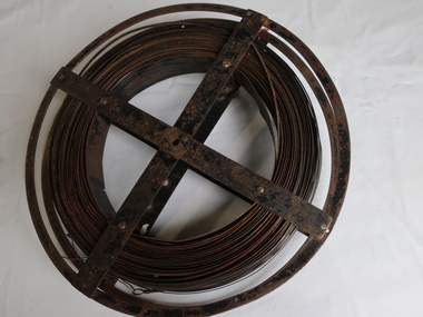 Kiewa Valley Historical Society
Surveyors Chain - Steel Band
A chain is a unit of length equal to 66 feet or 22 yards. This is a statute measure in the United Kingdom. One link is 100th part of a chain, which is 7.92 inches (20.1 cm). The chain and link became standard surveyors' units of length and crossed to the colonies from the United Kingdom. The chain is the unit of linear measurement for the survey of the public lands as prescribed by law. In Australia most building lots in the past were a quarter of an acre, measuring one chain by two and a half chains. Also street frontages, roads, laneways. The chain also survives as the length of a cricket pitch, being the distance between the stumps. Surveyors and residents of the Kiewa Valley used the Steel Band Surveyors Chain to measure distances when developing the land.Surveyors' steel band measuring tape, known as a 'standard band', or a 'steel band chain'.This chain consists of a long narrow strip of steel of uniform width of 3 mm and thickness of 0.3 to 0.6 mm. The chain itself is between 20 m and 30 m long.surveyors, surveyors chain, measurement of distance -
 Uniting Church Archives - Synod of Victoria
Photograph, Undated c.1980s
Reverend Dr. J. Davis McCaughey (12/07/1914 - 25/03/2005) was ordained in 1942 in Northern Ireland. He served at the YMCA, Fisherwick Belfast, United Kingdom, Professor of New Testament Studies at the Theological Hall, Master of Ormond College and retired in 1979. In 1986 he became Governor of Victoria, an office he held for six years.B & W photograph of Rev Professor Davis McCaughey seated at the podium with Justice Elizabeth Evatt at the ACC 29th General Meeting held in Adelaide."ACC 29th General Meeting Adelaide Justice Elizabeth Evatt addressed the meeting on the report on Human Relationships. Chairman of the session was the Rev Professor Davis McCaughey. Photo Rollason ACC"mccaughey, davis, rev., presbyterian minister, theological hall, ormond college, governor of victoria, justice elizabeth evatt -
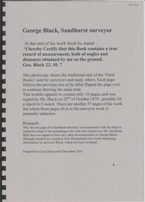 Bendigo Historical Society Inc.
Book - GEORGE BLACK, SANDHURST SURVEYOR, 2011
18 page spiral bound soft cover booklet 'George Black, Sandhurst Surveyor'. Photocopies of surveyor sketches Some background information on George Black was prepared by Julie Hempenstall Prepared by Carol Holsworth, December 2011.Carol Holsworth -
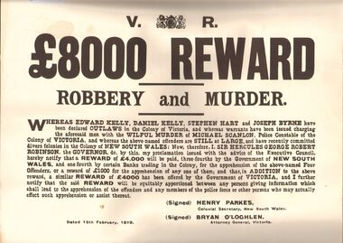 Bendigo Historical Society Inc.
Document - LYDIA CHANCELLOR COLLECTION: BUSHRANGERS
2 wanted posters, white with large black writing. 8000 pound REWARD. ROBBERY AND MURDER. Reward will be paid for information. The posters are announcing a reward for the apprehension of Edward Kelly, Daniel Kelly, Stephen Hart and Joseph Byrne. Signed Henry Parkes Colonial Secretary, N.S.W., Bryan O'Loghlen, Attorney General, VictoriaSigned Henry Parkes Colonial Secretary, N.S.W., Bryan O'Loghlen, Attorney General, Victoriahistory, australian, bushrangers, lydia chancellor, collection, australian history, history, bushrangers, victorian history, australia -
 Bendigo Military Museum
Photograph - Royal Australian Survey Corps Surveyors in the Field – Project Cutlass, New Guinea, 1956 – 1957
This is a set of 23 photographs of surveyors and support staff in the field undertaking tasks in New Guinea 1956 – 1957. The surveyors were employed in the establishment of mapping and geodetic control for Project Cutlass, the “Ship-Shore” survey of the New Ireland province. In this survey operation surveyors used theodolites to observe horizontal and vertical angles and chains to measure base line distances between survey stations. Bob Skitch shown in photo .7P was in the 2nd year of his career in the Australian Army. He achieved the rank of Lieutenant-Colonel, and his last appointment was the CO of the Army Survey Regiment from 1976 to 1980.This is a set of 23 photographs of surveyors and support staff in the field undertaking duties during Project Cutlass located in New Ireland, New Guinea 1956 – 1957. The photographs were printed on photographic paper and are part of the Army Survey Regiment’s Collection. The photographs were scanned at 300 dpi. .1) - Photo, colour, 1956. Surveyors travelling main road from Kavieng to Namatanai, New Ireland. .2) - Photo, colour, 1956. Unidentified surveyors assessing recovery of their vehicle after bridge collapsed on west side of New Ireland. .3) - Photo, colour, 1956. Unidentified surveyors assessing recovery of their vehicle after bridge collapsed over flooded creek on west side of New Ireland. .4) - Photo, colour, 1956. Survey personnel L to R: Bev Uwins, John Lambie, Bob Thompson, New Ireland. .5) - Photo, colour, 1956. Survey base camp, New Ireland. .6) - Photo, black & white, 1956-1957. Geoff Helsham with possible human remains, New Ireland. .7) - Photo, black & white, 1956-1957. Bob Skitch undertaking survey observations using Wild T2 theodolite, New Ireland. .8) - Photo, black & white, 1956-1957. Chas Beach undertaking survey observations using Wild T2 theodolite, New Ireland. .9) & .10) - Photo, black & white, 1956-1957. Kev Parker (cook) New Ireland. .11) - Photo, colour, 1957. Brian Berkery taking a break, Top Manor Island, Lihir Island Group off New Ireland. Latitude -2° 46”, Longitude 152° 40”. .12) - Photo, colour, 1957. Survey base camp L to R: Chas Beach, Bev Uwins, Feni Islands, New Ireland. Latitude -4° 05”, Longitude 153° 45”. .13) - Photo, colour, 1957. A Hous Kiap. (Kiaps, known formally as district officers and patrol officers, were travelling representatives of the British and Australian governments), New Ireland. .14) & .15) - Photo, colour, 1957. L to R: Joe Farrington, Tom Royle Bob undertaking survey observations using theodolites from an improvised timber tower, New Ireland. .16) & .17) - Photo, colour, 1957. US Army ship FS216 used for ship-to-shore triangulation docked at Rabaul, New Britain. .18) - Photo, colour, 1957. US Army ship FS216 used for ship-to-shore triangulation docked at Kavieng, New Ireland. Sight target on top of mast. .19) - Photo, colour, 1957. Survey personnel onboard US Army ship FS392, L to R: Peter Frodsham, Bob Thompson, Doc Reid, John Underwood, remainder unidentified, New Ireland. .20) - Photo, colour, 1957. Survey base line party heading ashore, New Ireland. .21) - Photo, colour, 1957. Survey personnel rowing US Army assault boat L to R: Kev Parker, Chas Beach, folded up survey beacons overhanging stern, New Ireland. .22) - Photo, colour, 1957. Les Bailey onboard US Army ship departing Rabaul, New Britain for Brisbane. .23) - Photo, colour, 1957. Ron Newman onboard US Army ship departing Rabaul, New Britain for Brisbane. Active volcano in background..1P to .23P annotated on back – ‘Operation Cutlass’, personnel names, the year and the location. royal australian survey corps, rasvy, army survey regiment, fortuna, a, army svy regt, asr, surveying -
Whitehorse Historical Society Inc.
Document, De Stoop dye and mattress ticking factory, 2006
History of the Best Estate as told by David Best.History of the Best Estate as told by David Best. Talk to General meeting of the Whitehorse Historical Society 3 June 2006. Tape at NP3394History of the Best Estate as told by David Best. best estate, blackburn north, camille de stoop australia pty ltd, joseph street, blackburn north -
 Whitehorse Historical Society Inc.
Vehicle - Box Wagon
Used as a general purpose wagon on the Livermore Orchard in Morack Road ,Vermont.Four wheeled General Purpose Box Wagon with central wooden shaft for two horses and an additional pair of shafts when using a single horse.rural industry, orcharding, transport, horse -
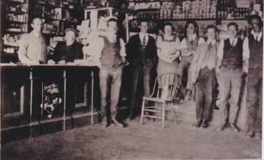 Phillip Island and District Historical Society Inc.
Photograph, Robb's store, Cowes, 1920
Inside of General Store. Probably Robb's as the photo was donated by Mary Robb. In background shelves stacked with groceries. Behind wooden counter, the Grocer standing and man in glasses, cap and seated along side Grocer. Standing in front of counter to one side, six waistcoated gentlemen and a lady. A wooden chair is located before the lady. An advertisement for Invicta Jelly Crystals is imprinted on the counter.Black and white photo of the inside of a general store, Thompson Avenue, Coweslocal history, photographs, buildings--historic, black & white photograph, mary robb -
 8th/13th Victorian Mounted Rifles Regimental Collection
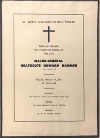
Document - Hammer funeral
Following a distinguished career in Second World War, General Hammer was Honorary Colonel 8/13 Victorian Mounted Rifles.Single sheet, printed with program and personalities relating to funeral of Major General HH ( Jack ) Hammer.. Glued to light card backing.hammer, colonel, vmr -
 Warrnambool and District Historical Society Inc.
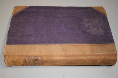
Letter book 13, 1920
This letter book contains letters, sketch maps and plans and dates from 1920 to 1923. It came from the office of John William Crawley Junior, an engineer, architect and surveyor in private practice in Warrnambool and also the engineer for the Shire of Warrnambool from 1895 to 1935. His father, brother and son were also engineers and worked in that capacity or as the Shire Secretary for the Shire of Warrnambool, with the Crawley family recording a total of 132 years of service to the Shire. The letter book was passed onto John Crawley’s son, Rolf, the engineer for the Shire of Warrnambool from 1935 to 1968. It then came into the possession of Michael Hand who took over the private surveying business on Rolf Crawley in Warrnambool. The Warrnambool and District Historical Society acquired the letter book, along with several other Crawley ledgers, from the estate of Michael Hand. This letter book is of considerable significance as it contains letters and maps drawn up by John William Crawley, an engineer in the Shire of Warrnambool for 40 years. It will be very useful for researchers.This is a dark red hard- cover letter book of 1001 pages. The book has brown binding on the corners of the cover and on the spine. There is gold lettering on the spine. The inside of the cover is lined with a multi-coloured mottled pattern. The cover is stained and scuffed. The pages contain handwritten letters, sketch maps and plans and an alphabetical index at the front. There are three loose pages. There is a mauve stamp on the first page.‘Letter Book 1920 to 1923’ ‘Rolf. L. Crawley Civil Engineer, Drainage and Water Supply Engineer, Licensed Surveyor, Registered Architect, Warrnambool’ john william crawley junior, warrnambool, rolf crawley, warrnambool, shire of warrnambool -
 Bendigo Historical Society Inc.
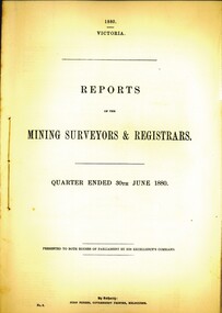
Book - MINING SURVEYORS AND REGISTRARS REPORT - 30TH. JUNE 1880, 1880
Reports of the mining surveyors and registrats quarter ended 30th. June 1880. 35 pagesVic. Govt.gold mining, miners' safety cage, surveyors and registrars report, bendigo, goldfields, gold mining, mining surveyors, registrars -
 Whitehorse Historical Society Inc.
Essay - Report, Talk by Keith Patterson, 1/08/1967 12:00:00 AM
Paper delivered to Nunawading Historical SocietyPaper delivered to Nunawading Historical Society on Clement Hodgkinson, surveyor of Nunawading by Keith PattersonPaper delivered to Nunawading Historical Societyhodgkinson, clement, nunawading historical society, patterson, keith arthur, philosophical institute of victoria, surveyors -
 Whitehorse Historical Society Inc.
Article, Memorial To Honour Work of Early Victorian Border Surveyors
Memorial to honour Surveyors Black and AllanMemorial to honour Surveyors Black and Allan who surveyed the straight line of NSW and VictoriaMemorial to honour Surveyors Black and Allanblack, alexander, allan, rmit -
Clunes Museum
Book - DIARY, LETTS SON & CO
DIARY WAS FOUND IN A HOUSE IN QUEENSLAND 40 YEARS AGO , BY MR.& MRS. HAY. ON MAY 20TH 2007, WAS DONATED TO THE CLUNES MUSEUM AT "CLUNES BOOKTOWN FOR A DAY"BROWN HARDCOVERED DIARY OF JOHN HOARE-SMITH, ENGINEER, SURVEYOR OR SECRETARY OF THE BOROUGH OF CLUNES.LETTS'S NO 9 DIARY 1865local history, documents, borough of clunes, diary -
 Orbost & District Historical Society
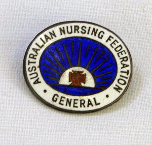
badge, Austalian Nursing Federation, c. 1920s
A badge presented to and worn by General Nurse, Ethel M Lynn in 1924.The Lynn family is well-known in the Orbost area. Ethel Lynn is believed to have been working at Bairnsdale in 1924. A badge possibly made of brass and with an enamelled face with the words AUSTRALIAN NURSING FEDERATION GENERAL printed, along with a red cross. A fastening pin is attached to the back. On the back is the name Ethel M Lynn, 1st July 1924.nurses-badge ethel-lynn -
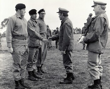 8th/13th Victorian Mounted Rifles Regimental Collection
Photograph
" A " Squadron 8/13 VMR won the 3rd Division Small Arms Competition in 1977.Black and white photograph of 3 soldiers of 8/13 Victorian Mounted Rifles with Commander of 3rd Division, Major General Jim Barrie at Divisional Shooting Competition Puckapunyal 1977." 3 Div Small Arms Competition 1977. Cpl. S. Loughton, Cpl. B. McDonald, Tpr. J. Ranftel being congrarulated by Major General Barry. " -
Port Melbourne Historical & Preservation Society
Plan - Shelter shed, Borough of Sandridge, Mar 1877
Hand drawn plan and elevation of tiny shelter shed "at manure depot in common", Sandridge 1877.Signed by Edward Wilson and Charles Clay (Surveyor)local government - borough of sandridge, built environment - civic, edward wilson, charles clay -
Port Melbourne Historical & Preservation Society
Map - Lagoon and beach, Sandridge, Borough of Sandridge, 1870
Map of Lagoon and beach with soundings, 1870.Signed by Chas. Clay, Borough Surveyor, Sandridge.charles clay, sandridge lagoon -
Port Melbourne Historical & Preservation Society
Plan - Path, Bay Street and Crockford Street, Municipality of Sandridge, 8 Oct 1861
Path works, west side of Bay Street and Crockford Street (both sides) bearing Seal of Municipality of Sandridge.Frederick William Ball, Muncipal Surveyor: Kellyengineering - roads streets lanes and footpaths, local government - borough of sandridge, frederick william bull, kelly (surveyor) -
Port Melbourne Historical & Preservation Society
Plan - Pathworks, Heath Street, Port Melbourne, Borough of Sandridge, 16 Feb 1861
Plan - Pathworks Heath StreetFrederick Wm. Bull Municipal Surveyor Sandridgeengineering - roads streets lanes and footpaths, frederick william bull