Showing 1548 items matching " aerial photographs"
-
 Ithacan Historical Society
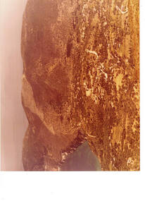
Photograph, Aerial photograph - Platrithia, Ithaca, c1970s
... Aerial photograph - Platrithia, Ithaca...The photograph is an aerial view of the village... Street Melbourne melbourne The photograph is an aerial view ...The photograph is an aerial view of the village of Platrithia in northern Ithaca, overlooking Afales Bay. The Taxiarchi Church is located at the top of the hill, around which the village is located.A discoloured landscape of an aerial view of Aphales Bay and Platrithia with the church of Taxiarches and the road which leads to Marmaka located on the other side of the mountain.aphales, villages -
 Lakes Entrance Historical Society
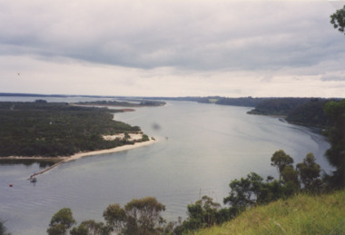
Photograph - Jemmys Point Lakes Entrance, Tidy Town Committee, 1996 c
... Aerial Photograph... 15 cm Aerial Photograph Township Topography Waterways Jemmys ...Also a second similar photograph number 03875.1 size 10 x 15 cmColour photograph taken from Jemmys Point looking west through the Gippsland Lakes to Metung with Rigby, Fraser and Flannagan Islands to the south Kalimna Victoriaaerial photograph, township, topography, waterways, jemmys point lakes entrance -
 Lakes Entrance Historical Society
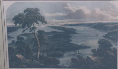
Photograph - Jemmys Point Lakes Entrance, 1880 c
... Aerial Photograph...Aerial Photograph Township Topography Jemmys Point Lakes ...Colour photograph print of early painting of view from Jemmys Point towards Metung showing paddle steamer and Aboriginals in bottom left hand corner Rigby Fraser and Flannagan Islands centre of painting, The Barrier on the left Nungurner Hills on right Gippsland LakesEntrance to The Gippsland Lakesaerial photograph, township, topography, jemmys point lakes entrance -
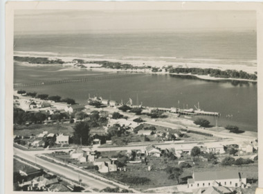
 Port Melbourne Historical & Preservation Society
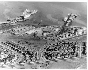
Photograph - Aerial view 1960s of Piers and surrounds
... the 1960s Photograph Aerial view 1960s of Piers and surrounds ...Gives a good overview of this area of Port Melbourne at a point in time. Identifiable objects are Station and Princes piers; Centenary Bridge; Commonwealth Government Marine Engine works; Beacons; Bank Houses; Commonwealth Oil fuel storage tanks; Missions to Seamen; Trugo club; Railway yards; Beacon Rad, Williamstown RoadPort Melbourne piers and surrounds. Aerial photo from the 1960spiers and wharves, built environment, mission to seamen, beacon -
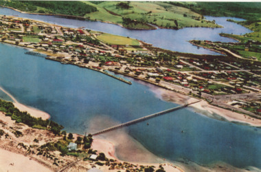
 Lakes Entrance Historical Society
Photograph - Lakes Entrance, Brian Lloyd, c1954
... Aerial Photograph... views in album Aerial Photograph Township Beaches Black ...Aerial view of Lakes Entrance c1954. Plus 2 other aerial views in albumBlack and white photograph of a section of the town taking in St Brendans church, Bulmer Street from Esplanade to Church Street, some of the waterfront, the footbridge and hummocks Lakes Entrance Victoriaaerial photograph, township, beaches -
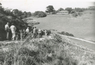 Lakes Entrance Historical Society
Photograph - North Arm Lakes Entrance, Lakes Post Newspaper, Frenchman's Gully, 1996 c
... Aerial Photograph...Aerial Photograph Topography Settlement Lakes Entrance ...Black and white photograph of Frenchman's Gully, track to Wyanga Winery showing group of people walking towards designated pickup spot for Winery bus Lakes Entrance Victoriaaerial photograph, topography, settlement, lakes entrance -
 Lakes Entrance Historical Society
Photograph - Lakes Entrance, 1952c
... Aerial Photograph...Aerial Photograph Township Colour photograph of town from ...Colour photograph of town from Myers Street looking west showing footbridge, Cunninghamme Arm and North Arm Lakes Entrance Victoriaaerial photograph, township -
 Buninyong & District Historical Society
Photograph - Aerial photograph (colour) Warrenheip St and DeSoza Park during Gold King Festival, February 1991, Crown Hotel Buninyong in 1993
... Aerial photograph (colour) Warrenheip St and DeSoza Park... in 1993 Crown Hotel Buninyong in 1993 Photograph Aerial photograph ...buildingsPhotograph of Crown Hotel Buninyong in 1993crown hotel -
 Whitehorse Historical Society Inc.
Photograph - Aerial Photograph, Burwood Technical School East Burwood
... Aerial Photograph.... Burwood Technical School East Burwood. Photograph Aerial ...Burwood Technical School was located on the south west corner of Middleborough and Elgar RoadsStrip of four coloured aerial photo of the Burwood Technical School Buildings taken sometime between 1986 and 1992.schools, burwood technical school -
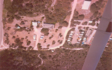 Lakes Entrance Historical Society
Photograph - Lake Tyers Beach Caravan Park, Jan. 1983
... Aerial Photograph...Aerial Photograph Caravan Parks Beaches Colour Photograph ...Colour Photograph of Ninety Mile Beach caravan Park at Lake Tyers Beach Victoria. Shows house rooftop, caravans and LTB Road on right hand side aerial photograph, caravan parks, beaches -
 Lakes Entrance Historical Society
Photograph - Frenchman's Gully/Taradale, 2000 c
... Aerial Photograph... 15 cm Aerial Photograph Topography Township Colour photograph ...Also a similar colour photograph number 03861.1 size 10 x 15 cmColour photograph of Frenchman's Gully showing Wyanga Winery vehicle on winery track with property Taradale of Leigh and Judy Davies on opposite hill Lakes Entrance Victoriaaerial photograph, topography, township -
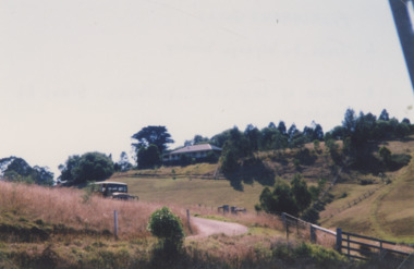
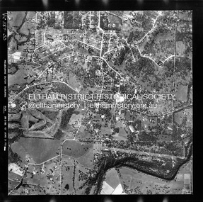
 Eltham District Historical Society Inc
Photograph - Aerial Photograph, Landata, Montmorency / Lower Plenty, 28 Jan. 1946
... Aerial Photograph... Photograph Aerial Photograph Landata ...Centred on 32 Grand Boulevard, Montmorency bounded by Rattray Road to north, Main Road, Lower Plenty to south, Bolton Street to east and Looker Road to west. Historic Aerial Imagery Source: Landata.vic.gov.au Aerial Photo Details: Project No :5 Project : MELBOURNE AND METROPOLITAN AREA PROJECT Run : 34 Frame : 61778 Date : 12/1945 (28.1.46) Film Type : B/W Camera : EAG4 Flying Height : 10200 Scale : 6000 Film Number : 212 GDA2020 : 37°43'30"S, 145°07'37"E MGA2020 : 334934, 5823043 (55) Melways : 21 E8 (ed. 42)aerial photo, bolton steet, looker road, lower plenty, main road, montmorency, phoebe mason collection, rattray road -
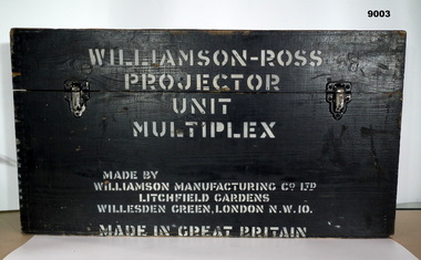 Bendigo Military Museum
Instrument - Multiplex Unit Projector, Williamson Manufacturing Co, Circa 1950
Multiplex mechanical stereoplotting equipment was used at the Army Survey Regiment, Fortuna Bendigo. c1950s. Multiplex equipment was imported from the UK in 1951 and introduced in the following year, to accelerate map production output covering CMF training areas at 1:25,000 map scale. Multiplex plotting was a productive advancement replacing the ‘Arundel’ method of graphical plotting planimetric detail that was expensive and slow, especially in timbered mountainous terrain. Air photos were made into small diapositives and mounted on racks in the exact position relative to when the aerial photos were taken. The technicians operated the Multiplex in a darkened room, with one photo projected with a green filter and the other through a red filter to form a 3D view of the overlapping photos. The 3D model projected onto a platen, which was a small platform that was raised up and down. The technician viewed the 3D image with special glasses fitted with red and green lenses. In the centre of the platen was a small pinhole that served as a floating mark, with a vertical pencil located exactly below the pinhole. This tracing table was moved to follow the topographic feature or contour line and draw it on the paper underneath. The technician raising or lowering the platform’s floating mark to match the height of the 3D terrain. It also replaced the slotted template method of mechanical adjustment of strips of aerial photography, however was restricted to each strip rather than between strips in the block. Although the Multiplex was phased out of production in 1968, it was used in the training of photogrammetry and aero-triangulation at the School of Military Survey located at Bonegilla, Victoria until the early 1990s. The history of the Multiplex is covered in more detail with additional historic photographs, in pages 50 to 51 of Valerie Lovejoy’s book 'Mapmakers of Fortuna – A history of the Army Survey Regiment’ ISBN: 0-646-42120-4. This instrument is only one of the projectors of a set and is unfortunately missing its platen coloured filters and coloured glasses.A black wooden box containing a Multiplex Unit Projector (incomplete). The Multiplex has a Lamp Head, Barrel Housing, Body of the Projector and a Platen which is missing.WILLIAMSON MANUFACTURING CO, PHOTOGRAPHIC ENGINEERS, SERIAL NUMBER 3437, TYPE MPC, LITCHFIELD GARDENS, LONDON AND READING.royal australian survey corps, rasvy, fortuna, army survey regiment, army svy regt -
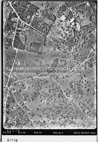
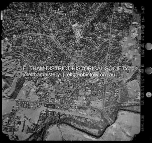
 Eltham District Historical Society Inc
Photograph - Aerial Photograph, Landata, Montmorency / Lower Plenty, Jan. 1962
... Aerial Photograph... Aerial Photograph Landata ...Centred on 147 Old Eltham Road, Lower Plenty bounded by Hurstbridge Railway Line to north, Yarra River to south, Main Road, Eltham to east and Heidelberg Golf Club to west. Historic Aerial Imagery Source: Landata.vic.gov.au Aerial Photo Details: Project No : 539 Project : MELBOURNE-GEELONG PROJECT Run : 6 Frame : 81 Date : 01/1962 Film Type : B/W Camera : RC5 Flying Height : 6000 Scale : 15840 Film Number : 1524 GDA2020 : 37°43'52"S, 145°07'26"E MGA2020 : 334685, 5822354 (55) Melways : 21 D9 (ed. 42)aerial photo, lower plenty, main road, montmorency, phoebe mason collection, eltham, eltham lower park, heidelberg golf club, hurstbridge railway line, main road eltham, yarra river -
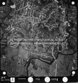
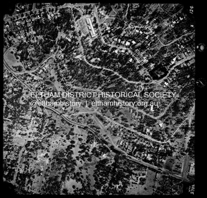
 Eltham District Historical Society Inc
Photograph - Aerial Photograph, Landata, Montmorency / Lower Plenty, Feb. 1956
... Aerial Photograph... PDF file Montmorency / Lower Plenty Photograph Aerial ...Centred on 20 Panorama Avenue, Lower Plenty bounded by Rattray Road to north, Yarra River to south, Bolton Street to east and Heidelberg Golf Club to west. Historic Aerial Imagery Source: Landata.vic.gov.au Aerial Photo Details: Project No : 250 Project : MELBOURNE OUTER SUBURBS PROJECT Run : 16A Frame : 53 Date : 02/1956 Film Type : B/W Camera : EAG9 Flying Height : 10000 Scale : 12000 Film Number : 1187 GDA2020 : 37°43'47"S, 145°07'25"E MGA2020 : 334645, 5822519 (55) Melways : 21 D9 (ed. 42)aerial photo, lower plenty, main road, montmorency, phoebe mason collection, bolton steet, heidelberg golf club, rattray road -
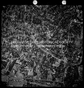
 Eltham District Historical Society Inc
Photograph - Aerial Photograph, Landata, Montmorency / Lower Plenty, Jan. 1973
... Aerial Photograph... Aerial Photograph Landata ...Centred on 385 Main Road, Lower Plenty bounded by Grand Boulevard, Montmorency to north, Old Eltham Road to south, Bolton Street to east and Panorama Avenue to west. Historic Aerial Imagery Source: Landata.vic.gov.au Aerial Photo Details: Project No :1043 Project : MONTMORENCY Run : 2 Frame : 124 Date : 01/1973 Film Type : B/W Camera : RC8 Flying Height : 2200 Scale : 4000 Film Number : 2722 GDA2020 : 37°43'48"S, 145°07'49"E MGA2020 : 335243, 5822507 (55) Melways : 21 E9 (ed. 42)aerial photo, lower plenty, main road, montmorency, phoebe mason collection, bolton steet, grand boulevard, old eltham road, panorama avenue -
 Eltham District Historical Society Inc
Photograph - Aerial Photograph, Landata, Montmorency / Lower Plenty, Mar. 1987
... Aerial Photograph... Aerial Photograph Landata ...Centred on 354-356 Main Road, Lower Plenty bounded by Rattray Road, Montmorency to north, Yarra River to south, Falkiner Street, Eltham to east and Lower Plenty shops to west. Historic Aerial Imagery Source: Landata.vic.gov.au Aerial Photo Details: Project No :1716 Project : WESTERN PORT FORESHORES Run : 16 Frame : 132 Date : 03/1987 Film Type : B/W Camera : RC10 Flying Height : 5600 Scale : 10000 Film Number : 4102 GDA2020 : 37°43'51"S, 145°07'38"E MGA2020 : 334968, 5822406 (55) Melways : 21 E9 (ed. 42)aerial photo, lower plenty, main road, montmorency, phoebe mason collection, eltham, eltham lower park, falkiner street, lower plenty shops, main road eltham, rattray road, yarra river -
 Eltham District Historical Society Inc
Photograph - Aerial Photograph, Landata, Montmorency / Lower Plenty, Nov. 1975
... Aerial Photograph... Plenty Photograph Aerial Photograph Landata ...Centred on 328 Main Road, Lower Plenty bounded by Rattray Road, Montmorency to north, Rosehill Road to south, Falkiner Street to east and Lower Plenty shops to west. Historic Aerial Imagery Source: Landata.vic.gov.au Aerial Photo Details: Project No :1243 Project : (ALSO A.P. 1227) Run : 24A Frame : 146 Date : 11/1975 Film Type : B/W Camera : RC8 Flying Height : 5000 Scale : 10000 Film Number : 2722 GDA2020 : 37°43'40"S, 145°07'32"E MGA2020 : 334820, 5822743 (55) Melways : 21 D8 (ed. 42)aerial photo, lower plenty, main road, montmorency, phoebe mason collection, eltham lower park, falkiner street, lower plenty shops, rattray road, rosehill road