Showing 2558 items
matching aerial
-
 Port Melbourne Historical & Preservation Society
Book - Port Melbourne Council, Sanitary Inspectors Report Book, J Mounsey, Sanitary Inspector, 1929 - 1936
James MOUNSEY - Council InspectorSanitary Inspector's Reports to Port Melbourne Council 1929-1936. Detailing duties re traffic, fire, building regulations, installation and use of petrol pumps, food labelling, street hoardings, crowd behaviour. Notes wireless aerials cause damage to chimneys when attached by wire p.88transport - motor vehicles, local government - city of port melbourne, environmental issues, health - general health, business and traders, industry, nightsoil, built environment, fishermans bend, livestock, engineering - canals and drainage, james mounsey -
 National Vietnam Veterans Museum (NVVM)
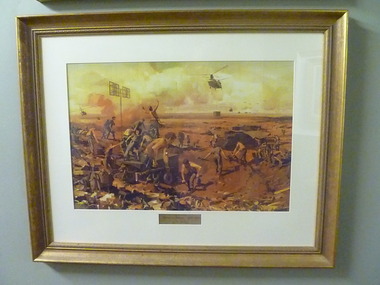
Print - Framed print, Signals, C.1978
Colour print of an oil painting in a gold frame with cream mat.The painting depicts a scene where army personnel lay cables in an erea where an aerial is up. On the horizon Helicopters come in, including a chiook, with supplies for the growing base.Signals operations being set up /run from back of APC'S'Signals in Vietnam' 1965 -1972 By Ken Mc Fadyen.print, helicopters, ken mcfadyen -
Port Melbourne Historical & Preservation Society
Document - Report, Plan of General Development, Mr J Green (Government Printer), Plan of General Development, 1929
Plan of General Development. Melbourne Report of Metropolitan Town Planning Commission, 1929. Was passed on by local history librarian as it was no longer required. On p63 shows view up Swallow Street and contrasts it with approach of St Kilda. P42 aerial view of Port Melbourne piers. Also includes maps and photographs.town planning, piers and wharves, swallow street -
Kew Historical Society Inc
Archive (series) - Subject File, Victoria Park : Concept Management Plan, Research Papers, 2004, 2004
Graeme Butler & AssociatesProject FilesProvenance OrderRed cardboard wallet containing historical research by Graeme Butler, heritage architect, into the history of Victoria Park, Kew. The file also includes a draft Victoria Park Concept Master Plan, 2004. The research includes memoranda, maps, photocopies of plans, forms, notes, aerial photos, and sundry references.graeme butler - heritage architect, victoria park - kew (vic), heritage studies - kew (vic.)graeme butler - heritage architect, victoria park - kew (vic), heritage studies - kew (vic.) -
 Lakes Entrance Historical Society
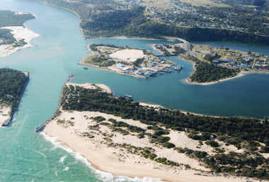
Photograph - Lakes Entrance, 2000
Colour photograph aerial view of the entrance, shows entry to North Arm, Cunninghame Arm, Bullock Island, part of Rigby Island, new North Arm Bridge in place, Club Hotel still in situ, small dredge working south west corner of Bullock Island. Lakes Entrance Victoriaislands, waterways, hotels, bridges -
 National Vietnam Veterans Museum (NVVM)
Photograph, C.1968
CITATION TO ACCOMPANY THE AWARD OF THE DISTINGUISHED FLYING CROSS (First Oak Leaf Cluster) Squadron leader Alan R Reed distinguished himself by extraordinary achievement while participating in aerial flight as and RD-4C Aircraft Commander in Southeast Asia on 24 August 1968. On that date, he flew his aircraft repeatedly through intense hostile ground fire to obtain complete photographic coverage of the target. In addition, he voluntarily remained in that hostile environment for as long as fuel would allow, to act as a spotter and to pass firing corrections to friendly artillery. The professional competence, aerial skill, and devotion to duty displayed by Squadron Leader Reed reflect great credit upon himself and the United States Air Force.Black and White photo in black and white frame of SQN LDR Alan Reed receiving a citation to accompany Distinguished Flying Cross 21 /08 /1968. with supporting info.flying cross, alan reed -
 Greensborough Historical Society
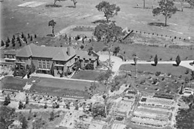
Photograph - Digital Image, Amberley Mansion from the air 1930s, 1930s
An aerial view of Amberley Mansion in Lower Plenty, taken during the 1930s. Amberley was built in the 1920 as a private residence and later as a centre for Christian Brothers. Located on a bend in the Yarra River and now known as Edmund Rice Centre Amberley, it is currently a conference centre, school camp and function centre.An example of an early 20th century building that has survived for over 100 year, with variations to its use.Digital copy of black and white photographamberley, edmund rice centre amberley, christian brothers, lower plenty -
 Warrnambool and District Historical Society Inc.
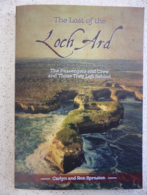
Book, The Lost of the Loch Ard, 2015
The Loch Ard had left England in March 1878 and 90 days later on June 1st it was approaching the coast of Victoria when it wrecked off the coast near Port Campbell at what was to become known as Loch Ard Gorge. Two people survived, Eva Carmichael and Tom Pearce. While much has been recorded about the survivors, this is the first publication which looks at the other 51 people on board. This book lists where they came from, family histories and lists internet references for further information. Some of the names listed are Yates, Stuckey, Jones, Rolleston, Godby, Mitchell, Fax, Hunt and Giles.An interesting insight into an aspect of the Wreck of the Loch Ard which has been previously unknown. Written by local authors.Soft card cover with coloured aerial photograph of Loch Ard Gorge Title in brown with sub title in white. Authors name in white on brown strip at bottom of cover. The back cover has blurb written in panel imposed over photo of Loch Ard Gorge looking seaward. 160 pages.Authors Carlyn and Ron Sproston.warrnambool, loch ard, lost of the loch ard, loch ard gorge, -
 Bendigo Military Museum
Photograph - PHOTOGRAPHS, 1939-1945
Albert Edward Corrie VX47191, Postal Unit.1. Four men leaning on truck. 2. Four men seated with mailbags. 3. Four men seated with mailbags. 4. Four men seated in a motor vehicle. 5. Two men feeding a seal. 6. Large pile of mailbags. 7. Aerial photo of 5 (five) aero planes. photographs, postal unit, ww2 -
4th/19th Prince of Wales's Light Horse Regiment Unit History Room
Equipment - Wireless Set No 19 Mk III, Pye, 1940 - 1948
These sets were made by Pye UK and various other companies under licenceEquipment used by the RegimentWS-19, a HF radio designed primarily for use in armoured vehicles, but also used as truck & ground station. Consists of three main units - sender/receiver, power supply unit and aerial tuning unit. Freq range A Set 2-8 MCs, B Set 229-241 MCsradio, wireless, 19 set -
 Victoria Police Museum
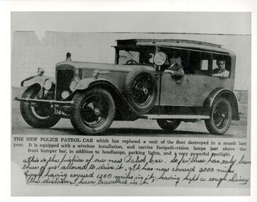
Photograph (police car), Kodak
Copy of newspaper clipping of new Daimler patrol car with unidentified driver and two passengers, registration number 114 427, circa 1931. This was the last 35HP 6 cylinder version purchased. Photo shows spot light, aerial tubing on roof, Police sign, and sideways facing front spot lightspolice vehicles; transport; motor police branch; daimler car; wireless patrol -
Bendigo Historical Society Inc.
Photograph - BENDIGO SHOWGROUNDS
Aerial black and white photograph of the Bendigo showgrounds. Date unknown. There is a sticker 'you are now here at the stand of Frank A. Hill & co. Several of the pavilion are named: horses (x4), cattle, pigs, Lansell Hall, sheep, wool, dogs, poultry booth, sideshows, centre hall, park road hall and luncheon.bendigo, streetscape, showgrounds -
Bendigo Historical Society Inc.
Map - FRED COWIE COLLECTION: AERIAL MAPS OF HEATHCOTE/EPPALOCK, 28-9-1960
Map, Heathcote C2, Township of Heathcote, Melbourne Road through town branching off to Bendigo & Echuca. Aerial Survey of Victoria. Photo-map prepared by Department of Crown Lands and Survey from photographs taken in 1960. Copied photographically at the Central Plan Office.Fred Cowie,46 McIvor Rd,Bgo..Central Plan Officemap -
Port Melbourne Historical & Preservation Society
Photograph - Aerial view of 3 liners at Station Pier, Port Melbourne, 14 Feb 2001
Large colour aerial photograph of 3 liners at Station Pier. Siver Cloud - outer East; QE2 - outer West; Regal Princess - inner West. View of Port Melbourne housing and foreshore development. Women's Welcome (or band) Rotunda on left of photo. Also a newspaper copy of the photo. COPYRIGHT RESTRICTEDmaritime, piers and wharves - station pier, transport - shipping, queen elizabeth ii, regal princess, silver cloud, beacon cove, swallow & ariell ltd, band rotunda -
Tatura Irrigation & Wartime Camps Museum
Document - Folder, Isabel Cameron, Moorilim Aerodrome, 2000 (estimated)
29th Light horse training at Murchison, also story of Moorilim Aerodrome.A4 black cover folder with plastic sleeves. 9 pages. Story of the aerodrome told by Isabel Cameron (nee Bronn) from her memory. Includes her own life history. Several aerial photos of the drome. In same folder 9 photos (sepia) of 20th Light Horse at training at Murchison.moorilim, moorilim aerodrome, isabel cameron, 20th light horse -
 Ballarat Tramway Museum
Photograph - Black & White Photograph/s, late 1960's
Black and white aerial photograph of the central area of Ballarat ranging from Mair St to Mt Pleasant, Drummond St and Victoria St. Taken late 1960's as it would appear that the construction of Sovereign Hill has commenced. Shows the tram tracks and possibly parking areas being marked out. On rear in pencil "2384/90"trams, tramways, ballarat, aerial views, sovereign hill -
 Falls Creek Historical Society
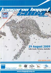
Poster - Kangaroo Hoppet 2009
The Kangaroo Hoppet is Australia’s premier long distance cross country ski race, and a member of the Worldloppet series of international cross country ski events. The first race at Falls Creek was held in 1979 under the name of “Australian Birkebeiner”. It was a 21km race with about 80 participants organised by the Birkebeiner Nordic Ski Club of Mount Beauty. The course started and finished at Falls Creek Alpine Resort and took participants out into the Bogong High Plains. After running the event for 10 years, it was decided they should become part of the Worldloppet series of marathon ski races. Representatives from the Birkebeiner Nordic Ski Club and the Australian Ski Federation attended the Worldloppet Annual Meeting in Finland in June 1990 to put the case for the acceptance of an Australian event into the Worldloppet series. Before being admitted, they had to demonstrate that the Birkebeiner Club could run a world class event, so three months later in August 1990 a 42km event named the Australian International Ski Marathon was held at Falls Creek together with a 21km Birkebeiner race and a 7km event called the Birkebeiner Lite. The event was approved by delegates from USA, Norway and Austria, in 1991 Australia became the 12th member of Worldloppet, with the condition that there had to be a name change. After some late night discussion allegedly involving red wine from North East Victoria the main event became the 42km Kangaroo Hoppet, with the minor events being the 21km Australian Birkebeiner, and 7km Joey Hoppet. In the winter of 1991, the first Kangaroo Hoppet was held. It was a great success and has been a regular fixture on the international ski calendar ever since. It features the main 42km event as well as a 21km event and a 7km event. The Hoppet brings the Australian snowfields to an international audience. In 2009 the Men's Winner was Ben Sim from Australia in a time of 0:58:39.4. The winner of the Women's event was Kate Calder of New Zealand in a time of 1:07:48.9. Due to the poor weather, and in view of skier safety and poor snow cover, a modified course was set. he Hoppet was reduced from 42 to 25 kms. This poster is significant because it documents an event which brings international attention to Falls Creek and the surrounding region.A poster with an aerial photo of a large number of skiers in the formation of the shape of a kangaroo. The colour of the border is blue, white and orange text is used. The Worldloppet logo is at the top left. The logos of AGL, Alpine Shire, Birkebeiner Nordic Ski Club, Parks Victoria, Tourism Victoria and Falls Creek are across the bottom of the poster. At the top: KANGAROO HOPPET 2009 NINETEEN At the foot of the kangaroo shape: 29 AUGUST 2009 FALLS CREEK, VICTORIA, AUSTRALIA In orange text: KEEP WINTER COOL FIGHT GLOBAL WARMING WWW.KEEPWINTER COOL.COM.AU At bottom in white text: www.hoppet.com.au kangaroo hoppet, worldloppet events, falls creek, mt. beauty -
 Bendigo Military Museum
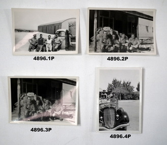
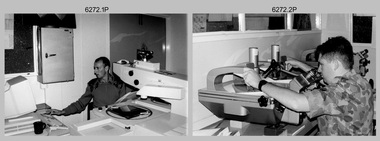
Photograph - Aerotriangulation Production – Army Survey Regiment, Fortuna, Bendigo, c1993
This is a collection of eight photographs of Air Survey Squadron personnel operating aerotriangulation equipment at the Army Survey Regiment at Fortuna, Bendigo, c1993. PUG4 devices were used by technicians to stereoscopically view the photography containing the survey control points and the mapping aerial photography. The Control points were transferred from the control photography to the mapping diapositives of aerial photography by drilling their locations into the photographic emulsion. The Zeiss (Jena) Stecometer analytic stereocomparator for air photography shown in photo .1P was introduced at Air Survey Squadron in 1963. Wild PUG4 point transfer devices shown in photos .2P to .4P were introduced in c1968 superseding the PUG2 devices. See item 6195.19P for more photos and descriptions of Air Survey Squadron personnel and aerotriangulation equipment.This is a set of eight photographs of Air Survey Squadron personnel operating aerotriangulation equipment at the Army Survey Regiment at Fortuna, Bendigo, c1993. The photographs were on 35mm negative film and were scanned at 96 dpi. They are part of the Army Survey Regiment’s Collection. .1) - Photo, black & white, c1993, Zeiss (Jena) Stecometer, SPR Kim Baker. .2) - Photo, black & white, c1993, Wild PUG4 point transfer device, CPL Paul Bouton. .3) to .4) - Photo, black & white, c1993, Wild PUG4 point transfer device, L to R: CPL Darren Scott, CPL Paul Bouton. .5) to .6P) - Photo, black & white, c1993, CPL Doug Willis. .7) - Photo, black & white, c1993, WO2 Noel ‘Macca’ McNamara. .8) - Photo, black & white, c1993, SGT Barry Miller..1P to .8P - There are no annotations.royal australian survey corps, rasvy, army survey regiment, army svy regt, fortuna, asr, aerotrig -
 National Wool Museum
Photograph
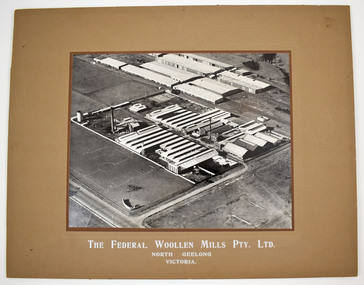
Black and white mounted photograph of the Federal Woollen Mill Pty Ltd, North Geelong, Victoria - aerial view showing all buildings and grounds which includes 2 tennis courts in the background and 1 basketball court in the foreground. Negative and proof available currently held as film 48 frame 18.Black and white mounted photograph of the Federal Woollen Mill Pty Ltd, North Geelong, Victoria.The Federal Woollen Mills Pty. Ltd. North Geelong Victoriawoollen mills history, federal woollen mills ltd, woollen mills - history -
 Greensborough Historical Society
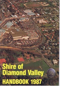
Booklet, Shire of Diamond Valley Handbook 1987, 1987_
Guide to services provided by Shire of Diamond Valley. The Shire of Diamond Valley was a Local Government Area located about 20 kilometres northeast of Melbourne. The shire covered an area of 74.38 square kilometres and existed from 1964 until 1994. Cover illustration of aerial view of Greensborough shopping area and environs.Annual guide to services in Shire of Diamond Valley32 pages, col illus., maps. 2 copies.shire of diamond valley, greensborough, handbooks -
 Victoria Police Museum
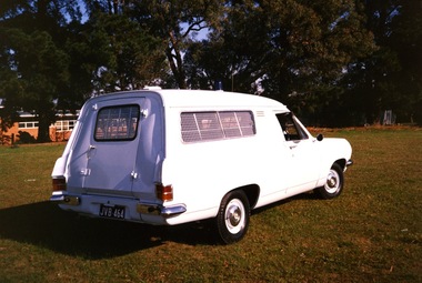
Photograph (police car)
Rear view of a 1967 Holden Divisional Van, registration number JVB-464, with a blue light on the roof and visible aerial. The van windows have visible reinforcement with a turn handle on the rear door. The background of the photograph has large trees and a single level brick building. There is no visible insignia on the car. Circa 1991police vehicles; motor transport branch; motor transport section; wireless patrol; holden van -
 Victoria Police Museum
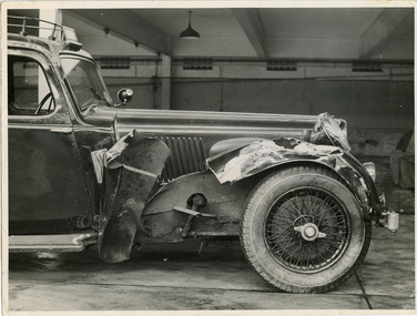
Photograph (police car), Kodak
Close-up photograph of 4.3 litre 6 cylinder Alvis Wireless Patrol car registration number 174-614 at Russell Street garage with significant damage to the front right hand wheel arch, circa 1937. Over the windscreen is the illuminated "Police" sign and on the roof are metals tubes containing the wireless aerials.police vehicles; transport; motor police branch; alvis car; wireless patrol; russell street -
Bendigo Historical Society Inc.
Map - FRED COWIE COLLECTION: AERIAL MAPS OF HEATHCOTE/EPPALOCK, 28-9-60
Map, Heathcote C4, Aerial Survey of Victoria,Photo-map prepared by Department of Crown Lands and Survey from photographs taken in 1960. Copied photographically at the Central Plan Office.Date 28-9-60,C.P.O.Neg.No.21590.Scale 4 inches to 1 mile. Fred Cowie,46 McIvor Rd,Bgo..Central Plan Office.map -
 Ballarat Tramway Museum
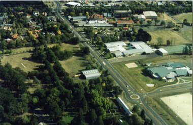
Photograph - Colour Photograph/s, Paul Mong, 29/03/2002 12:00:00 AM
Aerial photograph of the South Gardens Reserve and the Ballarat High School grounds showing the Ballarat Tramway Depot, Fish Hatchery and associated area from the north east aspect. Taken by Paul Mong 29 March 2002. On Fujicolor Crystal Archive Paper. Height of about 1000ft or 330m above ground level.btm, south gardens reserve, btm depot -
 Lakes Entrance Historical Society
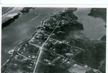
Photograph - Lakes Entrance, Bulmer H D, 1940c
Black and white photograph of aerial view of township. It shows route of Princes Highway through town, turning north at Myer Street and continuing along Roadknight Street. Few jetties on North Arm, many on Cunninghame Arm. In far upper left of image sea is breaking on sand hummocks. Lakes Entrance Victoriawaterways, township -
Bendigo Historical Society Inc.
Photograph - ELMORE FIELD DAYS
Elmore Field Days were first held in 1964.Aerial photograph of Elmore Field Days site. Undated but possibly 1969-1970. Image shows exhibitor stands, roadways and parked vehicles. Oh LH side of image is a water course, an anabranch of the Campaspe River. Site is now a camping reserve as the Elmore Field Days is now (2022) held at a nearby site.event, agriculture, elmore field days -
 Bendigo Military Museum
Photograph - Air Survey Squadron - Army Survey Regiment, Bendigo, c1988
This is a photograph of Air Survey Squadron, one of the Army Survey Regiment’s four squadrons, taken at Fortuna, Bendigo, c1988. Air Survey Squadron’s main functions were aerotriangulation and digital photogrammetric extraction of 3D topographic features from aerial photography, using Wild B8s coupled to the AUTOMAP 2 computer system.This is a photograph of Air Survey Squadron at the Army Survey Regiment, Fortuna, Bendigo, c1988. The photograph was printed on photographic paper and is part of the Army Survey Regiment’s Collection. The photograph was scanned at 300 dpi. .1) - Photo, black & white, c1988: Back Row L to R: SPR Mark Linwood, SPR Trevor Roddam, SPR Noel Brinsmead, CPL Mark Lander, CPL Frank Downie, SPR Sandy Craig 3th Row L to R: SPR Steve Rundle, unidentified, Darren Wilkinson, CPL Dave Longbottom, SPR Max Watson, unidentified, SGT Paul Hopes, unidentified. 2nd Row L to R: SGT John ‘Shep’ Shepherd, SPR Paul Boulton, SPR Stuart Bowd, SPR Paula (Golding) Brinsmead, SPR Jo Otto, CPL Steve Coulson, SPR Steve Linane, CPL Chris ‘Charlie’ Brown. Front Row L to R: SSGT Bruce ‘Hap’ Hammond, WO2 Barry Lutwyche, LT Struan Robinson, SSM WO1 Alan Hancox, OC MAJ Peter Clark, LT Simon Buckpitt, WO2 Neil ‘Ned’ Kelly, SSGT Noel ‘Macca’ McNamara.No personnel are identifiedroyal australian survey corps, rasvy, army survey regiment, army svy regt, fortuna, asr, air survey -
 Warrnambool and District Historical Society Inc.
Documents, Late 20th, early 21st centuries
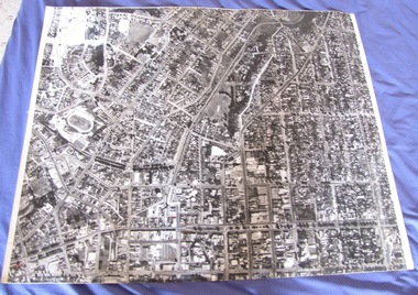
These ten documents (maps, plans, photographs) mostly come from the Warrnambool City Council and most contain information on sub-divisions and titles of properties in areas around the Central Business District of Warrnambool. The dates range from 1986 to 2006. These maps, plans and photographs are of some interest as they give historical details of subdivisions in Warrnambool and date from the late 20th century. .1 This is a laminated map of the boundaries of Local Governments in Victoria. It is Sheet I of 2 and has red and blue pencil markings and black boundary markings. .2 This is a copy of a plan of a survey in black and white markings on paper. .3 This is a plan of the title details of Section 19 Warrnambool. It has black printing on buff-coloured paper. .4 This is a plan of the allotments in part of the Central Business District of Warrnambool. It is printed in black and white. .5 This is a 2006 coloured aerial photograph of the harbour at Warrnambool – Breakwater etc. .6 This is a 2006 coloured aerial photograph of the Lake Pertobe area in Warrnambool .7 This is a coloured aerial photograph of Warrnambool’s streets over-stamped with road numbers in large blockings. .8 This is a plan showing the title details of Section 11 in Warrnambool. It has black printing on buff-coloured paper. .9.1 This is a plan of sub-divisions in parts of Crown Allotments 38 & 39 in Warrnambool. It has green, pink and yellow markings with black printing. .9.2 This is a plan of the sub-divisions in parts of Allotments 38 & 39 in Warrnambool. It has pink, yellow and blue markings with black printing. It is somewhat faded. warrnambool c.b.d. maps and plans, history of warrnambool -
 Bendigo Historical Society Inc.
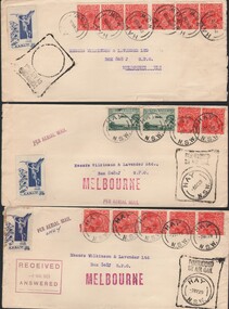
Document - BASIL WATSON COLLECTION: AIRMAIL ENVELOPES (SUNDRY ADDRESSED), 1929 (various)
Letters enclosed within cardboard enclosures. Written on outside ' Air Mail, 'Flown Covers' R.K. Munro, 63 Pyke Street, Bendigo, Vic. Aus.' Stamped underneath stamp 'booking agents for Australian Aerial Services Ltd. Per Aerial Mail'. Airmail Envelopes sundry addresses : 9 addressed to Wilkinson & Lavender, Melbourne - from Hay, NSW. (no contents); 1 addressed to K Munro c/o Box 808J GPO Melbourne - contains 3 used 3d. Stamps (Airmail Service). Stamped on back of one envelope: Wilkinson & Lavender Ltd., Riverina Office, Hay, N.S.W. Auctioneers, Stock & Station Agents, Sydney & Hay. Date 10 May, 1929, stamped on back of envelope.communication, postal, airmail -
 Plutarch Project
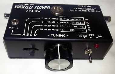
Machine - Shortwave Radio Antenna, Active Antenna, circa late 1980's
This antenna was used between 1989 and 1990 to help receive the daily news service in the Greek language directly from Athens, Greece. At the time, news from Greece for the Greek people in Australia were arriving in Melbourne a week late, on newspapers from Athens sent through air-mail. These newspapers were displayed at Salapatas and Carras newsagents at Lonsdale street in Melbourne. One thing that was a problem for this service was that the news came at least 7 days late. Using the Shortwave Antenna we could get the latest news from Athens on shortwave radio directly and within an hour these news were recorded on a cassette tape and taken to the Tricom Group P.L. offices in Melbourne (1155 Malvern Road, Malvern 3144). The tape was loaded onto a system which allowed people to call a local phone number and listen to the latest news with a cost of a local call, or a little bit more. As this was prior to the Internet being established around the globe, it was the fastest news service directly from Greece, in the Greek language. It was used for a span of about 12 months, until Tricom closed down their dial-in services, sometime in 1990. The service was captured and loaded onto the system by Iakovos Garivaldis, then an employee of the Tricom Group which was a subsidiary of Southern Cross TV.The Primary significance of this object is of its historical value, social and informative value for the first generation of Greeks in Victoria"World Tuner AT4 SW" antenna with a 920mm fully extended aerial, a tuned circuit and two transistors to prevent loading of the antenna and boost signal output. It is made of plastic, black in colour with the aerial being made of steel. The signals picked up by the antenna are fed via a 15pF ceramic capacitor to a tuned circuit consisting of either VC1a or VC1b and either L1, L2, L3 or L4. The slider switch S1 selects the band to be tuned. The band range is normally from 3 to 30MHz. When S1 is in position A, L1 and VC1a are selected and the antenna can be tuned from 3-9MHz. Similarly positions B, C, and D select higher frequencies up to 30MHz. It was purchased by Iakovos Garivaldis for this use for $119.WORLD TUNER AT4 SW "Amplituned" Shortwave Antennaantenna, radio, short-wave, language, greek