Showing 44511 items
matching 2011-12-27
-
 Eltham District Historical Society Inc
Audio - Audio Compact Cassette Tape, Audio Recording; Garnet Burges, Frank Burgoyne and Jock Read reminisce about earlier times in Eltham, 2 June 1988, 1988
Long time Eltham identities, Garnet Burges, Frank Burgoyne and Jock Read reminisce about Eltham in earlier years and comparisons with that of 1988. Facillitated by unidentified younger man.Three compact cassette audio tapes, TDK D60. Each tape labeled "G.B., F.B., J.R. 2/6/88" with Copy 1, 2 or 3 of 3 and "Dolby B" Location of Copy 1 to be determined Also Compact Disc with two MP3 files, copies of Sides A and B of Compact Cassette No. 1. Converted to MP3 files: EDHS_05005-1, Tape 1, Side A; 41.7MB; 0:30:25 EDHS_05005-2, Tape 1, Side B; 41.8MB; 0:30:27 EDHS_05005-3, Tape 2, Side A; 42.3MB; 0:30:51 EDHS_05005-4, Tape 2, Side B; 42.4MB; 0:30:52 EDHS_05005-5, Tape 3, Side A; 42.2MB; 0:30:44 EDHS_05005-6, Tape 3, Side B; 10.2MB; 0:07:29 EDHS_05005, Tapes 1-3; 184MB; 2:40:47audio cassette, audio recording, eltham, frank burgoyne, garnet burges, jock read, oral history -
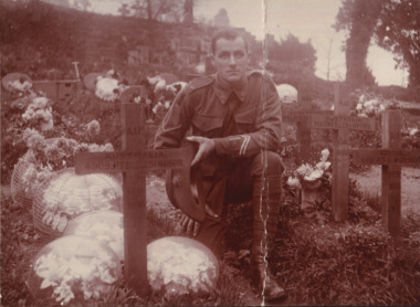 The Beechworth Burke Museum
Photograph
Taken on an unknown date, depicted is a portrait of a young, unidentified male soldier kneeling beside a grave in a cemetery. He is dressed in an Australian military uniform. The cemetery pictured is the Arnos Vale Cemetery in Bristol, United Kingdom. There are multiple crosses marking graves in this photograph, all marked in memory of different soldiers who fought with the Australian Imperial Force (AIF) during World War I. It is believed that the soldier who is kneeling was also part of the Australian Imperial Force. This can be inferred by the chevron rank insignia visible on the uniform. The placement of this insignia on the sleeve of the right arm suggests that this soldier was either a Warrant Officer or a Non-Commissioned Officer (NCO). Another signifier of the Australian Imperial Force uniform are the three inverted chevron stripes positioned on the lower part of the left sleeve, near the wrist. These are called Good Conduct Stripes and were worn by Warrant Officers and NCOs. This patch consisted of a single chevron stripe for each year of military service meeting certain requirements of good conduct. Additionally, the man in this photograph is also wearing a 'Rising Sun' collar badge on his coat. Australia, unlike most other Commonwealth countries, did not adopt metal regimental badges during the First World War. All units were issued with the Australian Army General Service Badge, better known as the 'Rising Sun’ badge. This insignia is almost always identified with the Australian Imperial Force. Furthermore, the grave that this unidentified soldier is kneeling next to is the resting place of Private John James (J. J.) Simpson. He was born in Stanley, Victoria in 1883. He enlisted in the Australian Imperial Force in Melbourne, Victoria on 12 July, 1915, with the service number 4909. John James Simpson was then posted to the 60th Company Depot at Seymour for military recruit training. John James Simpson was reported wounded in action in France on 19 July, 1916. He was admitted to 13th General Hospital, France with gunshot wounds to his legs. From Boulogne, France, he traveled to the United Kingdom aboard the Hospital Ship 'St. Denis' for medical care. Upon arrival, he was admitted to 2nd Southern General Hospital, Bristol, England on 27 July, 1916. John James Simpson passed away from his wounds on 1 August, 1916. He was 33 years old.The record is historically significant due to its connection to World War I. This conflict is integral to Australian culture as it was the single greatest loss of life and the greatest repatriation of casualties in the country's history. Australia’s involvement in the First World War began when the Australian government established the Australian Imperial Force (AIF) in August 1914. Immediately, men were recruited to serve the British Empire in the Middle East and on the Western Front. The first significant Australian action of the war was the Australian Naval and Military Expeditionary Force’s (ANMEF) landing on Rabaul on 11 September 1914. The ANMEF took possession of German New Guinea at Toma on 17 September 1914 and of the neighbouring islands of the Bismarck Archipelago in October 1914. On 25 April 1915, members of the AIF landed on Gallipoli in Turkey with troops from New Zealand, Britain, and France. This specific event holds very strong significance within Australian history. The record has strong research potential. This is due to the ongoing public and scholarly interest in war, history, and especially the ANZAC legend, which is commemorated annually on 25 April, known as ANZAC Day.Sepia rectangular photograph printed on matte photographic paper mounted on card.Obverse: A.I.F. / AUSTRALIA / 441, PTE.T. / T (?) / 26B (?) / 6.1.17 / (?) / LANGTON RD. / ST. ANNES PK. / BRISTOL / A.I.F. / AUSTRALIA. / 708, GNR B.L.CRAWFORD. / FR / 5 D.A.C. / 13.2.17 / A.I.F. / AUSTRALIA. / 4481, P (?) D.MORRIS. / (?) / 31.12.(?) / A.I.F. / AUSTRALIA. / 4909, PTE J.J.SIMPSON. / 608(?) / 1.8.16 / Winchester / LANGTON RD. / ST. ANNES PK / BRISTOL / Reverse: 2641 /military album, military, war, world war i, wwi, australian imperial force, aif, j. j. simpson, uniform, cemetery -
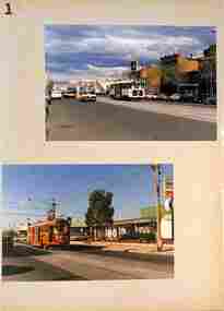 Melbourne Tram Museum
Album - Series of 40 colour prints, Brendon Carter, 1986
Set of fourty colour prints by Brendon Carter 1 - W2 444, Elgin St Carlton - Transporting Art - 15-10-1986 2 - W2 607. Grantham St West Brunswick - 17-10-1986 3 - W2 453 and W6 976 - Swanston St - 17-10-1986 4 - W2 453 ditto 5 - ditto, turning into Victoria St 6 - SW5 619 and W2 453 - Victoria and Swanston Sts 7 - W2 471 Swanston St 8 - W2 478 Swanston St 9 - W2 478 Swanston St 10 - W2 431 in Collins at Swanston St 11 - ditto 12 - W7s 1033, 1030, W2 243 and W6 972 Gisborne and Victoria Streets 13 - W2 436 - ditto 14 - SW2 432 and SW5 782 St Kilda Road 15 - W2 605 ditto 16 - W2 629 La Trobe St 17 - W2 629 and 644 La Trobe St 18 - W2 647 La Trobe St 19 - W2 547 Swanston St 20 - W2 441 - William and La Trobe Sts 21 - W2 1275 - corner of Park St and Domain Road 22 - W2 478 and SW5 730 - Swanston St at Flinders St. 23 - SW5 730 and W2 644 - ditto - 31-10-1986 24 - W2 547 at Flinders St Station - 31-10-1986 25 - W2 456 Swanston St - 14-11-1986 26 - W2 456 Domain & Park - 14-11-1986 27 - W2 456 ditto 28 - W2 458 and SW5 783 - William St - 14-11-1986 29 - W2 650 - West Preston terminus - 21-11-1986 30 - ditto - Gilbert Road 31 - ditto 32 - W2 431 - St Georges Road 33 - W2 431 - Miller St by Preston workshops 34 - ditto 35 - Miller St - the hump 36 - W2 646 at Preston Depot 37 - W2 646 at Dundas St at the start of the hump 38 - ditto on top with bridge works underway. 39 - W2 426 Hawthorn Bridge 40 - SW2 478 and SW5 833 - Camberwell terminus.Yields information about Melbourne Trams in 1986 when many W2s were still running.Album - 10 heavy card sheets with plastic sheets over each, white plastic ring bound, covered with a large photograph of Alf Twentyman's cable cars at Northcote. (see item 3086 for original unused version), with 40 colour prints, two per page and a listing or index of each print.Each print separately listed.swanston st, elgin st, grantham st, collins st, st kilda road, latrobe st, william st, gisborne, victoria st, domain road, st georges road, gilbert road, west preston, miller st, dundas st, hawthorn bridge, camberwell, w2 class, tram 444, tram 607, tram 453, tram 976, tram 619, tram 471, tram 478, tram 431, tram 1033, tram 1030, tram 243, tram 972, tram 436, tram 432, tram 782, tram 605, tram 629, tram 644, tram 647, tram 547, tram 441, tram 1275, tram 730, tram 456, tram 783, tram 650, tram 646, tram 426, tram 833 -
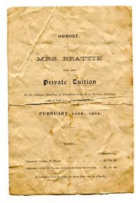 Orbost & District Historical Society
advertisement, 1902
Mrs Arthurena Dora Beattie (nee Morrison), had been teaching privately at Rosedale and came to Orbost with her husband and family in 1890. In 1892 she opened a private school in Salisbury Street (about the site of the Countryman Motor Inn) which she conducted for about 10 to 12 years. Her husband, John Wilson Beattie, a retired State School teacher, had been head teacher at the Rosedale School from July 1870 to August 1884. After coming to Orbost he selected land on Wall Creek. He was a widower with 7 of 11 surviving children when he married Arthurena in 1885. His fist wife, Georgina (nee KELLY) died at Rosedale in 1883 when the youngest child was just 5 weeks old. John and Arthurena had a further 8 children (5 born at Orbost), and after John's death she married George McCARLIE in 1916 at Sale and moved Mirboo North. (references:BEATTIE, Arthurena Dora Music teacher, Orbost - 1903 Electoral Roll. BEATTIE, Arthurena Dora Teacher, Orbost - 1912 Electoral Roll.) There was at least one other private school much earlier, in 1884. It was thought to be the first school in the district and conducted by William Ballantyne. It was located on the flat on the Newmerella side of the Snowy River near where the first railway crossing used to be. Wm Ballantyne had previously taught school at Sarsfield from June 1873 to November 1879. (information from John Phillips) This advertisement was for educational tuition by Mrs Beattie. Tuition would be from 10.00am - 12.00 and from 1.30pm - 3.30pm. Costs were thirteen shillings per quarter for children under the age of 12 years and one guinea for those over 12 years. A reduction would be given for more than one child in the same family. The 1872 legislation required all children aged 6-15 years to attend school unless they had a reasonable excuse. Parents who did not send their children to school were liable for fines up to five shillings for a first offence, with the penalty increasing to 20 shillings for each repeat offence. The Orbost State School had opened on 19th of March 1886 and this "private school" appears to have been a small private enterprise school. This is a useful research item associated with education in Orbost.A white A5 size paper advertisement which has black print. It is an advertisement for private educational tuition. Details of costs and hours are included.beattie education school advertising -
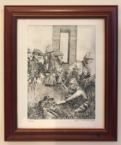 Tramways/East Melbourne RSL Sub Branch - RSL Victoria Listing id: 27511
Print - Gravure Print, Ataturk Commanding Turkish military campaigns 1915, 2015
A gift from the Turkish Consulate for the 100th Anniversary of Gallipoli.A framed gravure print by Erol Yildirim, edition is numbered as 48/100, and dated as 2015. The subject matter is concerned with Turkish military campaigns. On the revers of the print is a label with the following information. 'Biography of the Artist / Colonel Erol YILDIRIM (Ret'd) Born in 1959 in Bolu / Turkey, he completed his secondary education in Izmir, and began his military education at the Army War College in 1977. His career in arts started by attending the art club of the military college. He has organised 9 private exhibitions and taken part in 52 group exhibitions. He has won the following 8 awards. - 2009, 2010, 2011, 2012, 2013, 2014 Artmajeur Silver Awards - 2014 The XV Ex lib's Biennial as 'Selected exlibris' Miata Museum Ostrow Wielkopolski - POLAND - 2014 The 3rd Guangzhou International Exlibirs and Mini Print Biennial as 'selected exlibris guangzhou china' erol yildirim, turkey, print, artworks, war, turkish soldiers -
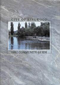 Ringwood and District Historical Society
Book, City of Ringwood, City of Ringwood 1992 Community Guide, 1992
Community information book issued by City of Ringwood for 1992 - covering the facilities and activities of the Ringwood Council and other local organisations and associations. Includes two Aquatic Centre entry vouchers valid until June 30th, 1992.CONTENTS: (page no.) 1991/92 COUNCIL REPRESENTATIVES 4 1992 CALENDAR 51 AQUATIC CENTRE 8 AQUATIC CENTRE VOUCHERS 49 CHIEF EXECUTIVE'S REPORT 6 CIVIC CENTRE TELEPHONE INDEX — DIRECT DIALLING 53 COMMUNITY DIRECTORY 35-47 COMMUNITY SERVICES 17-19 COUNCIL & COMMITTEE CYCLES 4 COUNCIL FINANCES & 1991/92 RATES 16 COUNCILLORS 3 FUNCTIONAL RESPONSIBILITIES 15 HISTORY OF RINGWOOD 5 HOUSING & RESIDENTIAL DEVELOPMENT 29-30 INFRASTRUCTURE 34 LOCAL, STATE & FEDERAL GOVERNMENT ELECTIONS 32 MANAGEMENT TEAM 14 MAYORAL MESSAGE – Cr. Max Williams 1 NEIGHBOURHOOD MAP 26-27 NOTES 52 PAPER & CARDBOARD COLLECTION SERVICE 22 PARKS & RESERVES — PUBLIC FACILITIES 31 PROTECTING OUR COMMUNITY 23-24 PROTECTING THE ENVIRONMENT 20-21 RINGWOOD FESTIVAL & HIGHLAND CARNIVAL 13 RINGWOOD GOLF COURSE 7 STRATEGIC BIKE PLAN 11 STREET INDEX A-L 25 STREET INDEX L-Z 28 THE LIBRARY 12 THE RINGWOOD CONVENTION & PERFORMING ARTS CENTRE 10 TRAFFIC MANAGEMENT 33 YOUR PERSONAL DIRECTORY 50 rinx -
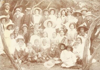 Ringwood and District Historical Society
Photograph, North Ringwood & South Warrandyte residents beach picnic c1905
Image O0054b has list of namesSmaller photograph with numbers and identification attached reads as follows: "North Ringwood & South Warrandyte residents beach picnic c1905. Photo from M. zoch, Hardings Rd. South Warrandyte. 1. Mr. Daniels, 2. Marion Coleman, 3. V. Zoch, 4. Mrs. Daniels, 5. Len Milne, 6. Miss D. Coleman, 7. Mic Johansen, 8. Mrs. Johansen, 9. Miss A. Sloan, 10. Mrs. Hussey, 11. Mrs. B. Milne, 12. Mrs. Tortice, 13. Bert Milne, 14. P. Coleman, 15. Miss J. Tortice, 16. Miss S. Tortice, 17 May Tortice, 18. Mrs. J. Coleman, 19. Claude Milne, 20. Rosie Johansen, 21, M. Zoch, 22 Harold Milne, 23. Miss O. Johansen, 24. Miss F. Sloan, 25. Eileen Mitchell, 26. Amy Johansen, 27. Roy Milne, 28. Stan Milne, 29. Dave Coleman, 30. Bell Mitchell, 31. Reg Danields, 32. Vicki Tortice, 33. Harry Tortice, 34. Millie Mitchell, 35. Florrie Tortice, 36. Bill Tortice, 37 Emily Tortice". -
 Eltham District Historical Society Inc
Photograph, Liz Pidgeon, Heritage Excursion; East of Eltham, 6 Sep 2014, 20 May 2017
Newsletter No. 218, September 2014 September Excursion - East of Eltham Walk In Newsletter No. 197, March 2011, there was a brief history of Crown Allotment 15 Section 5 Parish of Nillumbik (CA 15) a parcel of land of a quarter of a square mile extending from Eucalyptus Road to Reynolds Road at the eastern extremity of Eltham. From the 1940s it was known as Stokes orchard. In later years it has been subdivided for residential purposes but leaving significant areas as power line and water supply reserves and bushland reserves that are habitat for the threatened For our excursion on 6th September we intend to walk through CA 15 to a bushland reserve east of Reynolds Road. The walk will traverse the boundary between suburban Eltham and the non-urban areas to the south and east. This is a pleasant walk through residential areas and bushland. Along the way we will discuss the early and more recent history of CA 15 as well as local natural history and geology. This walk is about 3.5 km in length and will take 2 to 2.5 hours. It will start at 2pm at the corner of Eucalyptus Road, Pitt Street and Nyora Road.Born Digitaleltham east, eltham district historical society, heritage excursion, activities, nyora road, reynolds road, gum tree road reserve, diosma road, stokes orchard, eucalyptus road -
 Eltham District Historical Society Inc
Photograph, Liz Pidgeon, Heritage Excursion; East of Eltham, 6 Sep 2014, 20 May 2017
Newsletter No. 218, September 2014 September Excursion - East of Eltham Walk In Newsletter No. 197, March 2011, there was a brief history of Crown Allotment 15 Section 5 Parish of Nillumbik (CA 15) a parcel of land of a quarter of a square mile extending from Eucalyptus Road to Reynolds Road at the eastern extremity of Eltham. From the 1940s it was known as Stokes orchard. In later years it has been subdivided for residential purposes but leaving significant areas as power line and water supply reserves and bushland reserves that are habitat for the threatened For our excursion on 6th September we intend to walk through CA 15 to a bushland reserve east of Reynolds Road. The walk will traverse the boundary between suburban Eltham and the non-urban areas to the south and east. This is a pleasant walk through residential areas and bushland. Along the way we will discuss the early and more recent history of CA 15 as well as local natural history and geology. This walk is about 3.5 km in length and will take 2 to 2.5 hours. It will start at 2pm at the corner of Eucalyptus Road, Pitt Street and Nyora Road.Born Digitaleltham east, eltham district historical society, heritage excursion, activities, nyora road, reynolds road, gum tree road reserve, diosma road, stokes orchard, eucalyptus road