Showing 2048 items matching "pier"
-
 Melbourne Tram Museum
Letter, Australian Electric Traction Association (AETA), "Transporting Melbourne", 4/12/1996 12:00:00 AM
Letter - 8 A4 pages stapled in top left hand corner - AETA to "Transporting Melbourne", Ministry of Transport, dated 4-12-1996 forward comments or making a submission regarding the proposed framework. Endorse the concept, backlog in Melbourne public transport, railway electrification, tramway and light rail extensions; East Malvern Station, Box Hill, Station Pier, Westfield Shopping centre, Highpoint West, South bank Route and other suggestions made regarding re-routing of trams services.trams, tramways, aeta, submissions, new tramway, melbourne, public transport, box hill -
 Melbourne Tram Museum
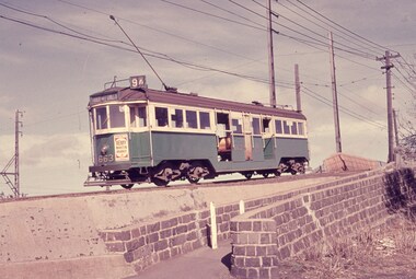
Slide - Set of 4, Keith Caldwell, 16/03/1966 12:00:00 AM
Set of four Perutz colour slides, grey plastic mount, photo by Keith Caldwell of trams using the single track bridge over the Epping Rail line, (the hump), Preston Workshops - Miller St. .1 - W3 663, Route 9A, Northcote via St Georges Rd. .2 - W2 455 eastbound. showing special - route 11 .3 - W5 749 - as for .1 .4 - W5 - can't read the number. shows the bridge pier prior to be reinforced and the train tracks. 16/3/1966In ink "Bourke 14.3.66" and a purple date stamp.trams, tramways, miller st, the hump, w3 class, w2 class, w5 class, bridges, preston workshops, northcote, route 9a, tram 663, tram 355, tram 749 -
 Orbost & District Historical Society
black and white photograph, mid 1930s
This is a photograph of McKillop's Bridge probably taken just after its rebuilding. The current McKillop’s Bridge was built by the Country Roads Board in two stages between 1931-36, during which its height was raised after the original bridge superstructure was washed away in record floods of January 1934, prior to its original official opening. In its reconstructed form the original concrete abutments were turned into additional piers and the welded-steel trusses were cantilevered back over them to meet the new higher road approaches. "McKillops Bridge was Heritage listed due to its social and technological significance – the steel trusses' arc-welded construction technique was a pretty big deal in the 1930s. It was once an important route for cattlemen, who used the ford across the Snowy in the years preceding the bridge's existence"This is a pictorial record of McKillop's Bridge just after its construction.A black / white photograph of a wooden bridge across a river. At the bottom right is a man with his back to the camera. He is looking at flood debris on the bank. At the bottom left are two men near a pylon.on back - McKillops Bridgebridge-mckillop's snowy-river-bridge -
 Flagstaff Hill Maritime Museum and Village
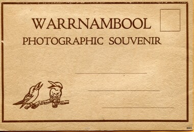
Postcard - Postcard Folder, scenes, Valentine & Sons Co. Publishing Ltd, Warrnambool Photographic Souvenir, Early-to-mod 20th century
This postcard folder is one of three in a set of postcards that were published in Victoria, Australia, and collected together. The Valentine Publishing Co. Pty. Ltd. produced this folder. Valentine and Sons was a printing and photography business based in Dundee, Scotland, and in Canada. In the early 1900s, at the height of the postcard craze, the firm published large numbers of postcards in the U.K., Canada, U.S., Australia and South Africa. From around 1900 or earlier, the firm bought many lithographic images for its postcards from local and national photographers who sold publishing rights to Valentines, and the business was famous for publishing photographs of popular sites worldwide. Postcard titles in this folder include many of those in the Rose postcard folders plus the following titles that are not duplicated. . Municipal Buildings and Post Office . Soldiers’ Memorial . Hopkins River . The Cliffs at Shelly Beach . The Road to Sandy Beach . The Breakwater and Pier This Valentine postcard folder was produced in Australia. It includes pictures from the early-to-mid 20th century. It is one of three in a set, with images of the same locations as other images in our collection but at different periods in time. Each postcard records a moment in history and is significant as a way to compare and show the changes in the local environment and community, building a story of the local history. The images record changes in the coastline, land, bay, buildings and other structures, roads, transportation and even the fashions of the times.Postcard folder, Valentine Publishing, cream cover. One of a set of three displaying images of Warrnambool and district around the mid-20th century. Print on the front and back covers is in brown ink. The front has an image of two laughing kookaburras on a branch, three address lines and an outline for a postage stamp. The back cover has the publisher’s details and a line for a return address. The cover opens like a book, and then the double-sided, Z-folded page of photographs drops downward. Titles are printed below each of the fifteen black and white photographs inside. The folder is secured on the back cover by placing a tab into a slot. The folder was produced by The Valentine Publishing Co. Pty. Ltd. Melbourne“WARRNAMBOOL / PHOTOGRAPHIC SOUVENIR” Symbol: [Two facing kookaburras standing on a branch with beaks open] “Published by The Valentine Publishing Co. Pty. Ltd. Melbourne” flagstaff hill maritime museum and village, great ocean road, shipwreck coast, warrnambool, flagstaff hill, flagstaff hill maritime museum, flagstaff hill maritime village, warramble, postcard, postcard folder, warrnambool scenes, picturesque views of warrnambool, picturesque views of warramble, lady bay, port of warrnambool, breakwater, warrnambool breakwater, viaduct, merri river footbridge, merri river suspension bridge, suspension footbridge, merri river mouth, hopkins river mouth, proudfoot's, fanny nelson, nelson's boatsheds, nelson's boathouse, boathouse, hopkins river boathouses, flett's boathouse, flett, george rose, image of a rose, rose series, rose stereograph co, rose stereographic company, lighograph, armadale victoria, lady bay beach, beach scene, lower light, concrete footbridge, 1922 footbridge, viaduct road, rose postcard, new concrete bridge, 1945, 1890, 1922, small footbridge, 1872 footbridge, 1872, merri river estuary, stingray bay, postcards, concertina fold, z fold, shipwrecked coast, maritime museum, souvenir, warrnambool local scenes, photography, local history, tourism, photographs, visitors, travel, scenes, mid-20th century, 1940s, 1950s, z-fold, 1880s, collection, correspondence, valentine publishing co. pty. ltd melbourne, valentine publishing co. pty. ltd sydney, municipal buildings and post office, soldiers’ memorial, hopkins river, the cliffs at shelly beach, the road to sandy beach, the breakwater and pier -
 Orbost & District Historical Society
black and white photograph, July 1922
A new bridge over the Snowy River at Orbost was opened for traffic on June 20th 1922. It was designed for future joint use by road and railway traffic, but it was only used for road traffic. During the last few years the condition of an old suspension bridge [the 1893 bridge] which was the only vehicular crossing between the town of Orbost and the railway station, caused much concern. The structure was of timber, except for the wire suspension cables of its central span of about 100 feet. A design was prepared in 1914 for a permanent bridge with five spans of 85 feet composed of plate girders on concrete piers. With great increase in the price of steel work during the war, the cost of this design became prohibitive, and the need for a new structure becoming urgent, alternative proposals were investigated. As a result the present design was adopted as providing a sem-permanent bridge at moderate cost. The new bridge spans the river about 160 feet upstream from the old bridge on a slight skew, the piers being at an angle of 80 degrees with the centre line of the bridge. It has a camber of about 2 feet 5 inches in its total length of 527 feet. ( information from Newsletter March 2014 - Lois Crisp) The photograph shows Mrs James Cameron cutting the ribbon at the opening of the Orbost Pile Bridge in 1922. This second bridge, was built by the Victorian Railways and the Country Roads Board. Constructed at a cost of 35,000 pounds and used second-hand girders from the Flinders Street- Spencer Street viaduct. On July 4 1922 it was officially opened by Mrs James Cameron. Unfortunately, her husband, who had long championed the building of the bridge so that it would be ready for the railway to continue to the border, was too ill to attend the ceremony. In fact, James Cameron died on July 13 after a long and severe illness (ref. S.R.M. 20.7.1922). There is a section of this ribbon in the collection - Registration No. 366. This is a pictorial record of a significant event in Orbost's history.A black / white photograph of a pile bridge with a suspension bridge behind it. There are many people standing on the bridge.on back - "Opening of Pile Bridge - 1922"snowy-river-bridge ceremonies cameron-mrs -
 Phillip Island and District Historical Society Inc.
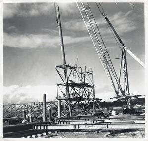
Photographs, Phillip Island 2nd Bridge Construction, 1966 - 1969
22 of a collection of 70 Black & White photographs taken during the construction of the second Phillip Island Bridge from San Remo to Newhaven by Country Roads Board and Shire of Bass. Contractor John Holland & Co. Pty. Ltd.14 Black & White photographs of the construction of the second Phillip Island Bridge in 1966 - 1969. 351-09: Pile driving on Newhaven abutment. 351-10 & 11: Concrete beams. 351-12: Pile driver. 351-13 & 14: Machinery. 351-15: Dismantled section of cylinder. 351-16 & 17: Coffer dam and pier construction. 351-18: Man up on scaffold. 351-19 & 20: Construction work. 351-21: Two workmen and man leaning on section of handrail exposed to weather. 352-22: View of construction work.Descriptions as above on some. Plus the following Numbering: 351-09: CRB NEG 67-274C. 351-10: CRB NEG 67-542. 351-11: CRB NEG 67-654F. 351-12: CRB NEG 66-605. 351-13: CRB NEG 66-601. 351-14: CRB NEG 68-752B. 351-15: CRB NEG 67-936. 351-16: CRB NEG 67-937A. 351-17: CRB NEG 67-937B. 351-18: CRB NEG 67-1156D. 351-19: CRB NEG 67-1156B. 351-20: CRB NEG 66-1026E. 351-21: CRB NEG 67-940. 351-22: CRB NEG 67-1218Bphillip island bridge construction, 2nd phillip island bridge construction, country roads board, shire of bass, sasha stark -
 Glenelg Shire Council Cultural Collection
Photograph - Sheet of 10 contact prints - Various Portland historic buildings and landmarks, c. 1970
Sheet of 10 contact prints of rephotographed photographs. Identifying numbers 5715a, b, c, d, e, f, g, h, i, j (a) Portland form Battery Point (b) Henty Beach, looking south (c) Palmer Street Primary School, No. 489 (d) Guardian Office, Bentinck Street (e) Railway Station Harbour Baths Bentinck Street (f) Jane Henty - wife of Stephen (g) bullock dray, bush (h) Ocean Pier (i) Bentinck Street Percy Street (j) Henty BeachFront: (a) Portland from Battery Point. - The Rose Series (c) .... School, Portland Vic. - Toys Photo (d) Bentinck Street The Guardian Office Portland. - Magnus Photo (e) Railway Harbour & Jetty (f) Price $3.70 (i) Bentinck Street Percy Street The Harbour and Town of Portland (j) Henty Beach, Portland -
Port Melbourne Historical & Preservation Society
Plan - CD-ROM, "State Bank of Victoria - Proposed dwelling Fishermans Bend"
Plans were brought to us by CBA employee Steve Tserkezidis CD with items below. From series of State Bankhouse plans and elevations of types 1 - 8. A1 copies (.01) 1937 (stamp). (.02) 1928. (.03) 1937. (.04) 1937. (.05) no date. (.06) 1928. (.07) 1937. (.08) 1938. From plans accompanying bank House plans .01 to .08; (.09) MMBW plan showing bank properties (.10) Bank house plan: sections through walls. (.11) "Fishermans bend group" plan of properties (.12) Bank House plan of Pier Foundationgarden city, built environment - domestic, state savings bank of victoria, bank houses -
 Port Melbourne Historical & Preservation Society
Photograph - Relating to Ed Whiting, 1930s
See 1833.02 for more information about Little Bay St. Ed WHITING lived in Dow St Port Melbourne in 1930s (A PMHPS Member in 2000s). Photos copied by Ed WHITING for PMHPS include Violet JOHNSON (now WOODS) as a little girl and later as a young woman. Shows 1930s Port Melbourne life.Note that .01, .02, .05 are in hard copy and a copy of all six is on database Black and white photos (copies) from the 1930s .01 - Ed WHITING and friend Ron .02 - Ed WHITING and three friends at BP filling station on Beach St near Princes Pier .03 - Ed WHITING and two friends in Port Melbourne lane.(database) .04 - Violet JOHNSON and friends, Port Melbourne backyard area (database) .05 - Violet JOHNSON and friend on Little Bay St .06 - Violet JOHNSON with pretend gun (database)families, domestic life, built environment - domestic, engineering - roads streets lanes and footpaths, edwin whiting, violet johnson, violet woods johnson -
Melbourne Tram Museum
Newspaper, Docklands News, “New late-night trams for La Trobe St”, Feb 2019
Newspaper clippings titled: “New late-night trams for La Trobe St” - Docklands News, February 2019, Issue 149. New tram timetable for Route 30 from January 1 2019. Tram services will run from St Vincent's Plaza to Central Pier until 1am on Fridays and Saturdays, and until midnight from Sundays to Thursdays. Previously there were no weekend services on route and weekday services finished at 6pm. Minister for Public Transport, Melissa Horne, said government making it easier to catch public transport.trams, tramways, route 30, docklands, la trobe st -
 Bayside Gallery - Bayside City Council Art & Heritage Collection
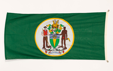
Flag, Evan Evans, City of Brighton flag
The coat of arms on this flag were granted by the British College of Arms in 1970 and represented Brighton City Council's "growing awareness of the importance of formality and correct symbolism in local government". It replaced the council's crest of a pier and yachting scene and was used as council's seal, emblem on its flag and letterhead. The new Coat of Arms, drawn up by the College of Arms in England, depicts the progression from a seaside gardening community to a modern residential city. The prominent forms are on the shield-like coat of arms include waves and a Lymphad (a ship, symbolic of the sea); a market gardener; an aboriginal man; two horns of plenty with abundant fruit and vegetables (the wealth and plenty) and Elster Creek (now Elster Canal). It is underscored by the motto "By their fruits, ye shall know them". Brighton was first incorporated as a borough on 18 January 1859, it became a town on 18 March 1887 and was proclaimed a city on 12 March 1919.Green flag with circular City of Brighton Coat of Arms in the centre. The central circle is white with a yellow edge, with a polychrome coat of arms featuring: the crest which is two cornucopia with fruits and vegetables, above sits a seagull. The mantle above the helmet is in green and gold. The shield is also green and gold with a lymphad (ship) and blue and white waves. The market gardener, holding a hoe, and Aboriginal figure, bearing a boomerang, support the shield and stand upon the compartment which is soil with a representation of Elster creek. A ribbon below contains the motto in blue 'FRUCTU NOSCITUR'.flag, brighton, city of brighton, coat of arms, college of arms, market gardener, aboriginal, elster creek, lymphad, fructu noscitur, armorial bearings, heraldry, cornucopia, by their fruits ye shall know them, motto -
 Lorne Historical Society
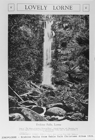
Pamphlet - Tourist Brochure, Lovely Lorne
The Victorian Railways promoted tourist destinations around Victoria. A folded paper tourist brochure about Lorne The front cover is a coloured painting of Lorne from above the Erskine River towards the main beach. , on the back is a black and white sketch tourist map of the roads, tracks and beauty spots. Inside the first fold are 6 black and white photographs, Cumberland River, Mt St George, Phantom Falls, Cumberland Cliffs, Teddy’s Lookout, leafy walk towards the pier. Inside contains written descriptions of the highlights of Lorne and six black and white photographs, four general views of Lorne, Lover’s Walk, Erskine Falls . souvenirs, victorian railways, publicity -
Glenelg Shire Council Cultural Collection
Photograph - Sheet of 12 contact prints - Various historic Portland buildings and Landmarks, c. 1970
Sheet of 12 contact prints of rephotographed photographs. Identifying numbers 5726 a, b, c, d, e, f, g, h, i, j, k, l (a) S.S. 'Dawn' at Railway Pier (b) Macs Hotel (c) Dr. C. Grier, Res. Julia Street (d) Bentinck Street, South from All Saints (e) Captain James Fawthrop (f) Bridge over Salt Creek (g) 'Prospect' (h) 'Windsor Cottage' (i) Bentinck Street from sea (j) London Hotel (k) 'Greenmount' (l) British fleet at anchor in Portland BayFront: (b) Macs Hotel (l) British fleet in portland Bay, Sept 30 1891 CN-865-G -
 Ringwood and District Historical Society
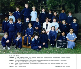
Photograph, Ringwood Primary School 1996 Class Photo Grade 2/3B, 1996
Grade 2/3B1996 Top Row: (Lto R) Tamara Groome, Rory Ashdown, David Doyle, Mitchell Paisley, Ashlee Winnen, Courtney Silvester, Varun Bhatia, Nicholas Macklin. 2nd Row:Newnest Addakula, Dinah Taualii, Shaun Chambers, Brendan McKee, Emily Eversteyn, Casey Baker, Mrs. Breen, Csilla Pajor, Megan Wiltshire, Ali Kiki. 1st Row: Shane Rixham, Piers Smart, Rachna Sok, Patrick Kellett, Sarah Cook, Natasha Kempton, Jane Truong, Jlksen Bulut. Teacher: Mrs. Christine Breen. Principal: Mr. Geoff Buzaglo. -
 Kew Historical Society Inc
Print - Walmer Street Foot Bridge
A bridge to Walmer Street, Kew, from Abbotsford was located at the northern end of Burnley Street. It was a foot bridge.Photographic print of the Walmer Street Bridge. The view of the Bridge is from the Abbotsford side of the Yarra. A section of pipe on the near side of the bridge is a remnant of the irrigation pipes that carried water from above Dight's falls to the Melbourne Botanic Gardens. The former bridge, constructed in 1896 was swept away in the 1901 Flood. It has two major brick piers while the remainder of the trestle supports are metal. The original photograph from which this copy was made was taken after 1901 as it shows the second bridge under construction. Houses in Young Street, Kew, can be seen on the far side of the river.Written on reverse: "Walmer St. Bridge. Erected 1896. Being rebuilt after 1901 flood damaged it. Houses on left are in Young St."bridges -- kew (vic.), walmer street bridge, melbourne botanic gardens -
 Kew Historical Society Inc
Print - Walmer Street Foot Bridge, 1901
Photographic print of the Walmer Street Bridge. The view of the Bridge is from the Abbotsford side of the Yarra. A section of pipe on the near side of the bridge is a remnant of the irrigation pipes that carried water from above Dight's falls to the Melbourne Botanic Gardens. The former bridge, constructed in 1896 was swept away in the 1901 Flood. It has two major brick piers while the remainder of the trestle supports are metal. The original photograph from which this copy was made was taken after 1901 as it shows the second bridge under construction. Houses in Young Street, Kew, can be seen on the far side of the river.Reverse: " Walmer St footbridge 1901 being repaired after flood / Constructed 1892 substantially renewed in 1901 and in 1928 / Rebuilt in 1977 by Kew Council aided by State funding. Won for designer Martin Aylard a New Zealand award presented by the timber Research & Development Assoc / Site of Simpsons Road passenger foot ferry". bridges - yarra river -- kew (vic.), walmer street bridge -- kew (vic.) -
 Eltham District Historical Society Inc
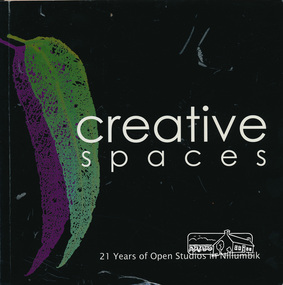
Book, Creative Spaces : 21 years of Open Studios in Nillumbik, 2008
Published for the Nillumbik Artists' Open Studio Program. Text edited by Tony Summers and Elizabeth Vercoe. All images by Tony Summers, Upfront Pictures unless otherwise credited. Contents: Nillumbik Artists' Open Studios, Nillumbik: an historic and artistic meander, Open Studio: a reflection, Open Studios: a historic reflection, the artists, the studios, Linda MacAulay, Chris and Mary-Lou Pittard, Linda De Toma, Peter Accadia, Wendy Hicks, Stephanie Mew, Piers Brown, Jane Annois, The Naughty See Monkey, Ona Henderson and Sydd Tunn, Robina and Tony Summers, Peter Oyston, Elizabeth Vercoe, Judy Racz, Veronia Holland, Shaaron Smith, Margaret Summerton, Kim Tarpey, Judy Trembath, Dena Ashbolt, The Bladessin Press, Rob Hayley. The Nillumbik Artists' Studios Program was created in the 1980s by the Shire of Eltham and continues to operate throughout the Shire of Nillumbik in 2018. The program offers the rare opportunity to visit studios and talk to artists about their work in their own working environment.Softcover bound book. Text with colour photographs. Includes profiles of artists from the Shire of Nillumbik. 95 pagesnillumbik artists' open studios, linda macaulay, chris pittard, mary-lou pittard, linda detoma, peter accadia, wendy hicks,, stephanie mew, piers brown, jane annois, the naughty see monkey, ona henderson, syd tunn, ronina summers, tony summers, peter oyston, elizabeth vercoe, judy racz, veronia holland, shaaron smith, margaret summerton, kim tarpey, ev hales, judy trembath, dena ashbolt, baldessin press, rob hayley -
 Eltham District Historical Society Inc
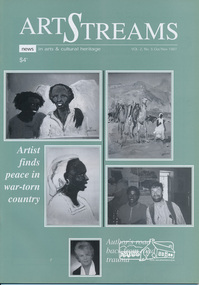
Journal, Peter Doughtery, ArtStreams: News in arts and cultural heritage; Vol. 2, No. 5, Oct-Nov 1997, 1997
Vol. 2, No. 5, Oct-Nov 1997 CONTENTS ART BRIDGES GAP IN WAR-TORN NATION Painter Piers Batman captures life in Eritrea 3 TENACITY OF THE HUMAN SPIRIT A teacher's road back from road trauma 7 EXHIBITIONS 10 POETRY Ray Liversidge 11 STUDIO WALKABOUT Artists open studios for Eltham Festival 12 ART FROM THE HEART Interview with Herman Pekel 14 ERITREAN JOURNEY Bill Moseley's camera in Eritrea 16 ART AND THE INTERNET Two Kangaroo Ground women bring art to a wider audience 18 HOUSE AND GARDEN IN SUBURBIA Exhibition of sculpture at Austin and Repatriation Medical Centre 20 THEATRE New Playbox - powerful advocate of Australian theatre 21 SHORT STORY Goodbye Dave, by Sherry Clarke 22 BOOK REVIEW 27 POETRY READING 28 BOOK REVIEW 29 EXPATRIATES COME HOME Former Nillumbik artists exhibit works 30 "Peter Dougherty has been involved in the local art scene for many years. As publisher and editor of the arts magazine Artstreams, his comments on the various branches of the arts are widely respected. His "The Arts" column in the Diamond Valley Leader presents a brief summary for a much wider cross section of the local community. Peter also operates his own gallery and the Artstreams Cafe at the St Andrews market. Peter has a wealth of knowledge about present day and historical aspects of local art and artists." - Eltham District Historical Society Newsletter No. 161, March 2005Colour front and back cover with feature articles and literary pieces with photographs and advertisements printed in black and white. 36 pages, 30 cm. Vol. 1, no. 1 (Nov. 1996) - Vol. 10, no. 5 (summer ed. 2005/06) art streams, thornton mccamish, bill moseley, eritrea, darebin festival, christine durham, michele lonsdale, ray liversidge, ona henderson, syd tunn, eltham festival, artists open studios program, nillumbik artists' open studios, david armfield, janet boddy, jules christian burns, wendy donald, jill forest, annie keil-taggart, ming bellamy mackay, jenni mitchell, grace mitchell, mervyn hannan, mary lou pittard, chris pittard, maureen runge, herman pekel, austin and repatriation medical centre, carolyn pickett, sherry clarke, manningham artspace, alan marshall short story award, eltham arts council inc., eltham library community gallery, harriot dance, chapman & bailey artists' stretchers and furniture, eltham high school -
 Myrtleford and District Historical Society
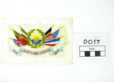
Postcard, 'Liberty and Justice' WW 1 postcard from France, 1917 - written by Leo Pallamountagne
Leo Charles Roy Pallamountagne was born at Moyhu, Vic, Aus. and at the time of WW 1 was employed as a farm hand on the property of Mrs Ellen McCormack (nee Power) at Ovens Vale, Victoria, Australia. Ellen's husband, John McCormack, had deceased 1916. Leo was born at Moyhu, Vic. 1899. He enlisted for service abroad on 30/8/1916 and was posted to the 21st Battalion, Serial No. 6829. Leo's next of kin was nominated as Clara Pallamountagne of Benalla, Victoria. Leo's father was listed as "whereabouts unknown" at the time of Leo's enlistment. Leo was wounded in action in France, Oct 1917. Leo returned to Australia on 10th March 1919 and was discharged on 17th April the same year. Leo (or Leon) married Evelyn Mary Paxman in 1922, they had seven children. Leo died on 23rd April, 1941 at the Military Hospital, Caulfield. Address in 1931 was Pier Street, Dromana. Occupation, Civil Servant Address in 1936 was Tresco, Victoria, Occupation, OrchardistMemorabilia of Leo Pallamountagne War Service on Western Front, France, 1917. Postcard of card and light gauze cloth upon which is embroided six flags in national colours flanking a rising sun plus wording in red on a blue ribbon flourish "For Liberty and Justice 1917"Hand written in pencil Addressed to Mrs J McCormack, Ovens Vale, Victoria, Australia. "France Sept 1917 To the Company just a few lines hoping you are all well as it leaves me at present There is not news here at present but will write again, Your true Friend Leo, Pallamountagnepallamountagne. western front. postcard. -
 St Kilda Historical Society
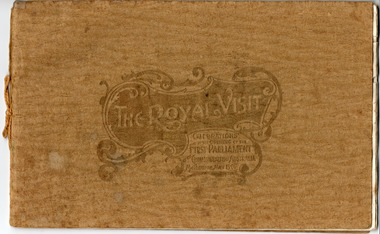
Memorabilia - Booklet, The Royal Visit Celebrations at the Opening of the First Parliament Commonwealth of Australia Melbourne May 1901, 1901
Booklet contains photographs of: THH the Duke and Duchess of Cornwall and York; Earl of Hopetoun, Governor General, and Countess; Commonwealth Ministry; The Royal Party at Government House Melbourne; TRH the Duke and Duchess Landing at St Kilda Pier; The Mayor of Melbourne Welcoming His Royal Highness at the entrance to the City; Procession Passing down Bourke Street; Presentation of War Medals to Victorian Soldiers; The Duke of York and his Staff; St Kilda and Prahran Arch; City Arch; Procession passing Princes Bridge; Opening Ceremony at First Federal Parliament; Citizens' Arch; Queen Victoria Arch; Royal Yacht Ophir; Warships Gromoboi (Russian) and Brooklyn (USA); German Arch; Chinese Arch; State School Fete at Exhibition Building; The University Commencement; Group of Fijian Constabulary; Laying Foundation Stone, Soldiers' Memorial Ballarat; Visit to South Star Gold Mine, Ballarat; Illuminations at Princes Bridge and Flinders Street Station; Illuminations at Parliament House and Treasury; Illuminations at Town Hall and City ArchGold coloured paper cover embossed and tied with gold thread. Contains 16 pages of cream coloured paper printed in black, some with blue decorative margins.Handwritten inscription on title page: 'For the Boy from Grandfather in memory of a very happy time we spent together May 1901'duke and duchess of cornwall and york, royal visits, 1901, opening of parliament, federation arch, st kilda and prahran arch, city arch, german arch, chinese arch -
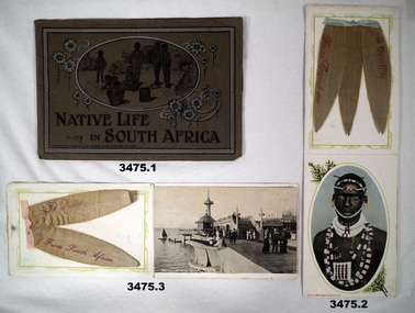 Bendigo Military Museum
Booklet - BOOKLETS SOUTH AFRICA WW1, c.1915
Items collected by Bert HEWSTON on the way to England WW1, refer Cat No 2759.2 for his service history. Part of the HEWSTON collection re WW1 & WW2.3 x Souvenir booklets from South Africa. .1) Dark grey/brown cover with illustration of native children within an oval shape. Contains colour prints of native people & places. 15 pages. .2) A coloured reproduction of a Zulu in marriage costume. Cream card cover with pale brown printing. Contains 3 x dried silver leaves fromTable Mountain fused to the inside back cover. .3) Photo post card of Promenade Pier, Cape Town which has 2 x dried silver leaves from Table Mountain fused to the inside the back cover..1) Printed: “Native life in South Africa” .2) Printed: “Zulu in marriage costume SA” .3) Printed: “From South Africa”documents - booklets, military history - souvenirs, africa -
 Federation University Historical Collection
Book, Railway Practice: a collection of working plans and practical details of construction in the public works of the most celebrated engineers, 1847 (exact)
A green cloth hard cover book. Title and author's name are engraved in gold on spine. This is the 3rd edition, first series with black and white illustrations. It describes the engineering practices of the early days of British railroads. The book includes (series 1 to 4)and it contains, roads, tramroads and railroads, bridges, aqueducts, viaducts, wharfs, warehouses, roofs, and sheds, canals, locks, sluices, & the various works on rivers, streams, etc., harbours, docks, piers and jetties, tunnels, cuttings and embankments, the several works connected with the drainage of marshes, marine sands, and the irrigation of land, water-works, gas-works, water-wheels, mills, engines.civil engineering, railway practice, rail constructions, s c brees, western railway great britain, public works, railroads, canals, s.c. brees, samuel brees, samuel charles brees -
 Kew Historical Society Inc
Photograph - Filling in the Outer Circle Railway cutting at East Kew, 1939
W.D. Vaughan (Kew's Civic Century, 1960, pp.195-6) quotes Council Minutes of 1938 and 1939 to record that: "After protracted negotiations between the Council, the Railways Department and the Tramways Board agreement was reached in June, 1938, for the filling of the railway cutting at the Harp Junction and shifting tram tracks to the High Street alignment ... The Outer Circle railway land from Princess Street to Park Crescent was purchased by the Kew Council in October, 1939, for 2,750 [pounds]. The land from Park Crescent to High Street was leased for 1 [pound] per annum. Considerable work was done in levelling the embankments to the original surface level."Important and rare photograph of the period, showing major works by Kew Council in Kew East working on a significant piece of urban infrastructure.Small, original black and white positive (photograph) showing workers and vehicles filling in the tracks of the former Outer Circle railway at East Kew. In the background is the metal bridge with brick piers, adjacent to the Harp Junction. The bridge crossed the cutting, linking the two parts of High Street. Behind the tip truck, painted on the side with the name 'Fowler Quarries' [located Keilor Road, North Essendon], one can see shops [including T.G. Garroway, Cash Grocer] in High Street. What appears to be the City of Kew Steamroller is immediately in front of the bridge. A group of passers-by watch from the bridge and from the road. Annotation in pencil on verso: "Filling in Outer Circle line at High St East Kew prior to straightening High St. (c. Feb 1930?)outer circle railway, railway cuttings, harp junction, high street -- kew east -
 Wodonga & District Historical Society Inc
Album - Hume Reservoir Australia Album - Excavations for foundations inside coffer dam, January 1927
This set of photos is from a leather bound album bearing the inscription "HUME RESERVOIR AUSTRALIA" plus 'The Rt. Hon. L. C. M. S. Amery, P. C., M .P.' all inscribed in gold. It was presented to The Rt. Hon. L. C. M. S. Amery, P. C., M. P, Secretary of State for Dominion Affairs on the occasion of his visit to the Hume Reservoir on 2nd November 1927. This album is of local and national significance as it documents the planning and development of the Hume Reservoir up to 1927. It was the largest water reservoir in the British Empire. The album records the pioneering engineering work that went into its construction.DEPARTMENT OF PUBLIC WORKS, N.S.W. RIVER MURRAY WATERS SCHEME. HUME RESERVOIR. 21. Excavations for foundations inside coffer dam. New South Wales. January 1927. Cofferdams are temporary structures used where construction is being carried out in areas submerged in water. They are most commonly used to facilitate the construction or repair of dams, piers and bridges. To divert the river, a Coffer Dam was built across the old bed above and below the Dam site and tying into the end of the concrete wall built inside the levee bank. This completely surrounded the remainder of the site of the Dam and south wing wall, including an area of 12½ acres. hume reservoir australia, river murray waters scheme, hume reservoir construction, coffer dam -
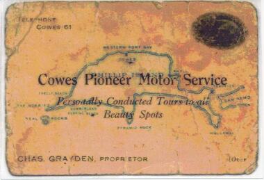 Phillip Island and District Historical Society Inc.
Photograph, 1925 - 1936
Two of a collection of 6 photographs donated by Anne Grayden. First photograph "Registration" No. 199-05 Second Photograph "Registration" No. 199-061. Colour photograph of front of Charles Grayden's Business Card. Map of Phillip Island in the background. 2. Colour photograph of back of Charles Grayden's Business Card.1. On Front: Telephone Cowes 61 - Cowes Pioneer Motor Service - Personally Conducted Tours to all Beauty Spots - Chas. Grayden, Proprietor - [over On Back: Business Card of Charles Grayden 1925 - 1936. 2. On Front: Personally Conducted Tours to all Beauty Spots including Nobbies & Summerland Surfing Beach, Newhaven, Forrest's Caves & Rhyll. Evening Trips to Mutton Bird & Penguin Rookeries. Agents for Ideal Summerland. Booking Office, opposite Pier, near Koala Cafe.charles grayden, cowes pioneer motor service, anne grayden, tourism phillip island -
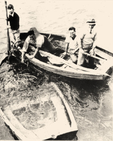 Queenscliffe Maritime Museum
Photograph - Black & white photographs of LB Queenscliffe & sunken dinghy rescue, Queenscliffe & sunken dinghy
Lifeboat & rescue crews.Lifeboat Queenscliffe crew & sunken dinghyBlack & white photos of [a] 1986-158.1 B & W photo of sunken rescue dinghy and [b] the LB Queenscliffe heading out for practice.Reverse - " on 158.1 - L to R / Frank Ferrier, Ron Shapter, Tony Jergens, Tom Warren / sunken 14 ft dinghy used in rescue of wreck of Merlan / This sat on Lonsdale pier for a considerable time (2 years?) prior to rescue. When they put it in to rescue the dinghy commenced filling and rescue were carried out while bailing - 158.2 - Queenscliffe heading out for practice / man at stern (late Jack Ferrier) / "AKUNA' pilot vessel in background formerly German raider 'KOMET' ".historical references -
 Wodonga & District Historical Society Inc
Album - Hume Reservoir Australia Album - Driving first row of piles for coffer dam across the river, December 1925
This set of photos is from a leather bound album bearing the inscription "HUME RESERVOIR AUSTRALIA" plus 'The Rt. Hon. L. C. M. S. Amery, P. C., M .P.' all inscribed in gold. It was presented to The Rt. Hon. L. C. M. S. Amery, P. C., M. P, Secretary of State for Dominion Affairs on the occasion of his visit to the Hume Reservoir on 2nd November 1927. This album is of local and national significance as it documents the planning and development of the Hume Reservoir up to 1927. It was the largest water reservoir in the British Empire. The album records the pioneering engineering work that went into its construction.DEPARTMENT OF PUBLIC WORKS, N.S.W. RIVER MURRAY WATERS SCHEME. HUME RESERVOIR. 19. Driving first row of piles for coffer dam across the river. New South Wales. December 1925. Cofferdams are temporary structures used where construction is being carried out in areas submerged in water. They are most commonly used to facilitate the construction or repair of dams, piers and bridges. To divert the river, a Coffer Dam was built across the old bed above and below the Dam site and tying into the end of the concrete wall built inside the levee bank. This completely surrounded the remainder of the site of the Dam and south wing wall, including an area of 12½ acres. hume reservoir australia, river murray waters scheme, hume reservoir construction -
 Bendigo Historical Society Inc.
Photograph - T C WATTS & SON COLLECTION: 62 CARPENTER STREET, BENDIGO, 1930
Black and white photographs (s) mounted on rectangular brown board. House, two storey, brick, roughcast above dado height, upper storey has shingles under windows shingles below front gable. Brick verandah piers with wooden freized upperparts. Two stepped masonry approaches, two event verandahs. Roughcast to lower walls below floor level, lower window with six lights [5 leadlighted] On back of photo ' Phillips, Carpenter Street. £2500 sewered with all furnishing including wireless set but not including sewing machine, piano or organ and £3000 with all furniture'. 2012 photo of house attached to record.bendigo, business, t c watts & son -
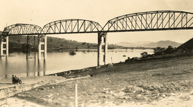 The Beechworth Burke Museum
Photograph
Taken between 1928 and 1930, depicted is the Bethanga Bridge under construction. The Bridge was completed in 1930 and was built to assist residents of the Bethanga district to travel to Albury. Other bridges would become submerged by the backed-up water of the Murray and Mitta Rivers so the Bethanga bridge was built two miles above the Mitta Weir. The Bethanga Bridge was built north of the future Hume Dam which would be completed in 1936. At 2430 feet long, Bethanga Bridge was the longest road bridge in Australia at the time of its completion. The Bridge is 20 feet wide and made up of nine 270 feet long spans. Materials used include ten tons of paint for the steel works; 1600 tons of steel; 900 tons of timber for the decking; and reinforced concrete for the piers. The tender for the construction was awarded to C. Ruwolt Pty. Ltd., engineers who were located on Victoria Street, West Richmond. The contract was awarded for £71,890. It was predicted between 250 and 300 men would find employment on the project. The news was well received by trade unions at the time as there had been a drop in available engineering work.This photograph is historically significant as it depicts the progress of the Bethanga Bridge construction, which was important infrastructure for the area. It is also a good example of methods used in the area to assist in travel over the river prior to the construction of the Hume Dam.Black and white rectangular photo printed on matte photographic paper.Reverse: 1997 3186 / 84-19-3 / This is the bridge. / It is not yet open to traffic / yet. will not be completed / until May next / It is a wonderful bridge the / pillars are 100 feet high. / KODAK PRINT Envelope Obverse: Peterson PHOTO / Hume Weir Envelope Reverse: BMM 84-20-1,2+3. bethanga bridge, lake hume, hume dam, hume weir, murray river, bridge, bethanga, albury -
Glenelg Shire Council Cultural Collection
Photograph - Sheet of 12 contact prints of rephotographed photographs - Various Portland land marks, c. 1970
Sheet of 12 contact prints of rephotographed photographs. Identifying numbers 5725 a, b, c, d, e, f, g, h, i, j, k, l (a) Bentinck Street from sea (b) James Robertson store (c) Bentinck Street south from All Saints (d) Fawthrop Lagoon (e) Henty Beach Cliffs (f) Bridge over Salt Creek (g) Res. Dr. C. Grier, Julia Street (h) Group of men sitting/standing outside wooden building (i) Henty Woolstores, Julia Street (j) S.S 'Dawn' tied up to railway pier (k) All Saints Catholic Church (l) Cliffs at Henty Streetfrom the front: (b) James Robertson store (c) Bentinck Street, Portland - Nicholls (e) Cliffs above Henty Street (f) Bridge over Portland drain (i) Henty Woolstore and Observer buildings, Julia Street