Showing 4563 items matching "the avenue"
-
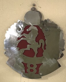 8th/13th Victorian Mounted Rifles Regimental Collection
Decorative object - 8LH template
This object was originally made for and affixed to a memorial rock at Beersheba Barracks Sisley Avenue Wangaratta. When 8/13 Victorian Mounted Rifles departed Beersheba Barracks, the panel was removed with the intention of placing it in another location. This did not occur so the panel is held in the Heritage Collection.Two piece metal cutout of the 8th Light Horse hat badge.8th, light horse, wamgaratta, rock, beersheba -
 Chelsea & District Historical Society Inc
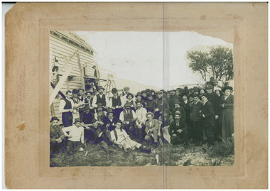
Photograph - Methodist Church built in a day, Methodist Church, Sherwood Ave, Chelsea, 26 June 1915
On June 26th an army of workmen gave their services for free, built the Methodist Church in Sherwood Avenue, Chelsea. A weatherboard building, 35 x 20 feet, with Gothic style amber white glass windows. The first service was held in the Church at 6:00pm the same day.Black and white photo of men taking a break from their work, building the Methodist Church in Sherwood Ave, Chelseareligion, methodist, building, chelsea, community -
 Greensborough Historical Society
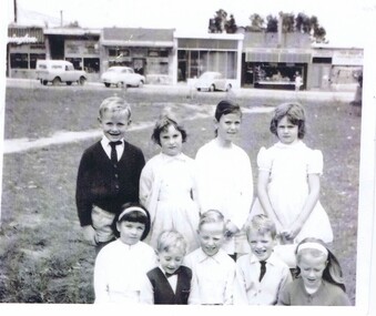
Photograph, Keith Willimott, Children at Church of Holy Spirit Watsonia c1968, 1968c
Holy Spirit Church of England Sunday School Watsonia c1968 Back row: Ian Hatfield, Front row: Julie Mullinger? Mark Miller, Mark Ballard, Ken Willimott & Ann Hogan. Behind the children are the Watsonia Road shops, corner Watsonia Road and Morwell Avenue.Black and white photograph"Holy Spirit C of E Sunday School Watsonia 1968? Back row Ian Hatfield Front row Julie Mullinger? Mark Miller, Mark Ballard, Ken Willimott & Ann Hogan"holy spirit church of england watsonia, willimott family, morwell avenue watsonia, watsonia road watsonia -
 Kew Historical Society Inc
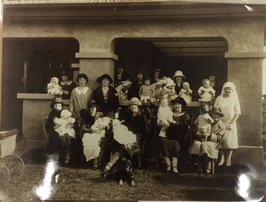
Photograph, East Kew Baby Health Centre, 1920s
Most likely the original photo was taken at or around the time of the official opening of the baby health centre. The building is located in Windella Avenue, Kew East and is still extant. The photo is taken in front of the front verandah of the building. This print is on Kodak photo paper, likely printed circa 1978. The East Kew Baby Health Centre was the first such centre built in the former City of Kew, and one of the first in Victoria. Few photos of the building at the time of its establishment are known. Reproduction print of black and white photograph of group of mothers and their babies, with nurse, in front of health centre.Reverse: "East Kew Baby Health Centre". kew east, baby health centre, windella avenue, maternal health, nursing -
 Warrnambool and District Historical Society Inc.
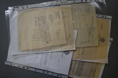
Administrative record (collection) - Documents relating to house in Warrnambool, 1951
Collection maintained by daughter of original owner.Historical reasonsCollection of items in folder in chronological orderCorrespondence from Government and legal sourceswarrnambool housing post world war twowarrnambool housing post world war two -
 Surrey Hills Historical Society Collection
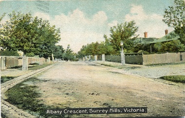
Postcard, Albany Crescent,Surrey Hills, Victoria Postcard
We hold 2 copies of this post card, the image of which which had been hand-tinted. The tree guards along the street prevented horses from browsing on their bark and leaves. The street on the right is probably Beatrice Avenue. SLV collection dates the post card as c1906.A coloured stamped postcard identified as Albany Crescent, Surrey Hills, Victoria showing the tree plantings on the naturestrips, gutters and houses with picket fences.SHP2213a Postcard front "Albany Crescent, Surrey Hills, Victoria". On the back is a message addressed to Mr N Smith at Phillip Island from "Ada". SHP2213b Received 2001 See our postcard print also/ From Julie Jones Heritage Officer Whitehorse/ after Heritage Trails published/ Have an original card already.albany crescent, surrey hills, ada, mr n smith, phillip island, post cards, 1901-1910 -
 Eltham District Historical Society Inc
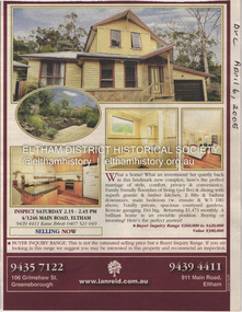
Document - Property Binder, 1246 Main Road, Eltham
Newspaper advertisement: Diamond Valley Leader, 6 April 2005, Ian Reid estate agent, sale of 4/1246 Main Road Eltham. Newspaper advertisement: Diamond Valley Leader, 6 April 2005, Ian Reid estate agent, sale of 7 Kelvin Avenue Montmorency,main road, eltham, property, ian reid real estate -
 Ringwood and District Historical Society
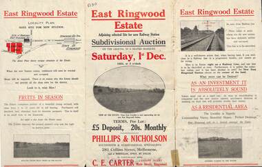
Flyer, Subdivisional Auction Sale Brochure, East Ringwood Estate, Vic. - 1923
Tri-folded double sided advertisement for subdivisional auction sale on Saturday, 1st December, 1923, including location map and summary of local facilities and services.Subdivision includes Patterson Street, Bona Street, Miller Grove, Fairview Avenue and Eastfield Road. Auctioneer - Phillips & Nicholson, 281 Collins Street, Melbourne. Tel. Central 10907. Agent - C.E. Carter, Main Street, Ringwood. Tel. Ringwood 24. -
 Phillip Island and District Historical Society Inc.
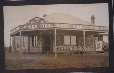
Photograph, H Gullifer Corner Store, Cowes, Phillip Island, 1906
One of earliest buildings in Cowes main street. Largely painted wares advertised on front and two sides of H Gullifer's Corner Store.Corner store, Thompson Avenue. No neighbouring shops. Neat building. Six posts front and two sides. Six windows. Door in middle of wide "V" frontage. Two chimney pots at rear. Definition on front 1906 H. Gullifer Corner Store. To left "Ropes & Boots" to right "Groceries & Cordials". Beneath window on right "Summer & Drinks" "Ice Cream"local history, photographs, buildings - historic, h gullifer's corner store 1906, black & white photograph, betty kus collection, thompson avenue cowes, phillip island, bruce bennett -
 Whitehorse Historical Society Inc.
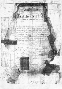
Document, Blackburn, 1/08/1995
Photocopy of Certificates of Title Vol 2105 Fol 420823 being 480 acres, part Crown Portions 81, 82, 89, 90, and 91 to Freehold Investment and Banking Co of Australia Limited, 9 January 1889. Includes plan of the area bounded by Central Road, Blackburn Road and Stanley Road, (now Wellington Avenue) Blackburn and transfers 1890 - 1926.land subdivision, central road, blackburn, blackburn road, gordon crescent, stanley grove, quarterman, martha, clarke street, grieve, robert, brown, james, game, kate, lincolne, phyllis marian, richardson, william wheeler, wellington avenue, thomas robinson -
 Surrey Hills Historical Society Collection
Map, Contour map of Surrey Hills showing potential sites for the Telecom Tower
The PMG / Telecom / Telstra tower was built in 1961-1963 as a relay station to support television and radio links between city and regional broadcasting stations. The tower itself was 45 m in height with a 2 storey building for equipment and staff surrounded by garden. From the beginning it was opposed by local residents. The location is said to be the second highest site in Melbourne, sometimes described as Delaney's Hill.Two A3 photocopied sheets of a map showing part of Surrey Hills, roughly between Windsor Crescent and Belmont Street (north / south) and Standard Avenue and Balmoral Crescent (east / west). The map shows contour lines and house sites, 16 of which are numbered. One sheet has been inscribed in top RH corner with notes regarding the significance of the numbers."Contour map of potential sites / for the telecommunications tower which / was eventually sited at 2. / Jock Campbell OBE was our neighbour / at 4 Theodore St when we moved into / the area in 1984. He was responsible in his / job at the PMG in deciding on the /site of the tower - Note site 5 was / behind his (& our) house. / Jack ended his career as Deputy Director / of the PMG. He sat on international committees / after WW2 to decide the split of the electronic / spectrum for radio, TV etc. / His group developed a "mobile phone" using / fixed towers but the phone was a truck full of gear."contour map, telecom tower, maps, jock campbell, john duncan campbell -
 Bendigo Historical Society Inc.
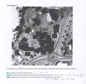
Photograph - Site Diagram of the Bendigo East Primary School
The sheet of photocopied A4 size paper shows an aerial photograph of the Bendigo East State School and the location of significant trees on school property. The trees have been numbered and colour-coded. Blue: Avenue of Honour Sugar Gums, Green: Commemorative Sugar Gums planted on school grounds. Red: Indigenous trees which are not associated with commemorative plantings. Gemma Starr Collectionbendigo east state school, bendigo schools, gemma starr collection, school avenue of honour -
 Lakes Entrance Historical Society
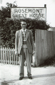
Photograph - Rosemont Guesthouse/Willis, Willis, Barbara, 1951c
Photo taken during honeymoon of Ron and Barbara Willis 1951Black and white photograph of Ron Willis, standing outside Fraser's Rosemont Guest House, Barkes Avenue. Guest house sign is behind a tall hedge and low picket fence. Ron is wearing clothing typical of 1950 era, with collar and tie, V-necked patterned pullover, light coloured two-piece suit and lace-up shoes. Lakes Entrance Victoriamotels, fences, clothing -
Glen Eira Historical Society
Article - Craigellachie
An auction advertisement from the Melbourne Weekly Bayside, dated 11/05/2011, for Craigellachie at 2B and 2C Lynedoch Avenue, St Kilda East. The article includes one colour photograph (155mm x 257mm) of the exterior of Craigellachie and three colour photographs (84mm x 60mm) of the interior of Craigellachie.craigellachie, lynedoch avenue, gary peer real estate, zelman sally, krongold darren, kingston phillip, estate agents, st kilda east, architectural styles, architectural features -
 Greensborough Historical Society
Map, Melbourne and Metropolitan Board of Works. Survey Division, MMBW, Yarra 2500 / 16.23. Diamond Creek, 1978_02
Melbourne and Metropolitan Board of Works. Yarra 2500 [base map] 16-23. Diamond Creek. Parish of Nillumbik 3310. Municipalities of Diamond Valley 257 and Eltham 238. Prominent streets include: Phipps Crescent, Bishop Avenue, and Reynolds Road. Includes the former Diamond Creek Technical School.MMBW Map in 1:2500 [scale] series. Cream parchment with green tape reinforcing on edges and punched holes on left edge.mmbw, melbourne and metropolitan board of works, shire of diamond valley, diamond creek - maps -
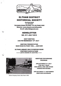 Eltham District Historical Society Inc
Newsletter, Newsletter, No. 211 July 2013
Contents: • Next meeting, Presentation: Main Road Eltham 1968…..And Now • July Meeting • July Excursion – Mud Bricks, Pise and Other ‘Character Houses’ • Nillumbik Reconciliation Plaques • A Busy Time for Enquiries, Donations and Other Things • Mac Ball • Former Hat Factory • Avenue of Honour • And Also The Shire of Eltham Historical Society was formed in October 1967. The first newsletter of the Society was issued May 1978 and has been published continuously ever since on a bi-monthly basis. With the cessation of the Shire of Eltham in late 1994, the Society's name was revised to Eltham District Historical Society and this name first appeared with issue No. 103, July 1995. The collection of the Society's newsletters provides a valuable resource on the history of the Society's activities, office bearers and committee members, guest speakers and subjects of historical interest pertinent to the former Shire of Eltham and the Eltham District.A4 photocopied newsletter distributed to membersnewsletter, eltham district historical society, shire of eltham historical society -
 Melbourne Tram Museum
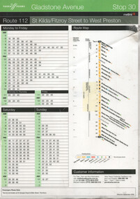
Ephemera - Route 112 Gladstone Ave timetable, Yarra Trams, Sept. 2006
Ephemera or sign for Stop 30, Gladstone Avenue Northcote stop on Route 112 St Kilda/Fitzroy route, dated Sept, 2006. Shows the layout adopted at the time for tram stop information. Details times for trams scheduled to leave the stop. Has phone numbers for Yarra, Metlink and their logos.Yields information the information provided by Yarra Trams at tram stops for passengers.Sign - laminated printed colour A4 sheet.trams, tramways, yarra trams, metlink, route 112, tram stops -
 Kew Historical Society Inc
Plan - Subdivision Plan, Wimba Estate, Kew, c.1925-c.1929, ca. 1925-ca. 1929
Pru Sanderson, in her groundbreaking ‘City of Kew Urban Conservation Study : Volume 2 - Development History’ (1988), summarised the periods of urban development and subdivisions of land in Kew. The periods that she identified included 1845-1880, 1880-1893, 1893-1921, 1921-1933, 1933-1943, and Post-War Development. These periods were selected as they represented periods of rapid growth or decline in urban development. An obvious starting point for Sanderson’s groupings involved population growth and the associated economic cycles. These cycles also highlighted urban expansion onto land that was predominantly rural, although in other cases it represented the decline and breakup of large estates. A number of the plans in the Kew Historical Society’s collection can also be found in other collections, such as those of the State Library of Victoria and the Boroondara Library Service. A number are however unique to the collection.Subdivision plans are historically important documents used as evidence of the growth of suburbs in Australia. They frequently provide information about when the land was sold on which a built structure was subsequently constructed as well as evidence relating to surveyors and real estate and financial agents. The numerous subdivision plans in the Kew Historical Society's collection represent working documents, ranging from the initial sketches made in planning a subdivision to printed plans on which auctioneers or agents listed the prices for which individual lots were sold. In a number of cases, the reverse of a subdivision plan in the collection includes a photograph of a house that was also for sale by the agent. These photographs provide significant heritage information relating house design and decoration, fencing and household gardens.In 1925, the City of Kew called for tenders for the construction of Wimba Avenue, Cadow Street and Lalla Street. Subsequent advertisements for the sale of land in Wimba Avenue continued from 1926 to 1929. The 18 lots (and a further five allotments on the eastern side of the street) offered for sale were unofficially described in the subdivision plan as the ‘Wimba Estate’. These lots began in Park Hill Road and extended almost to Cotham Road. The subdivision took its name from the house ‘Wimba’ in Cotham Road, which may have formed the southern boundary of the subdivision. (Wimba, at 235 Cotham Road was constructed between 1862-70). The Plan highlights the proximity and advantage of ‘electric’ trams in Cotham and Glenferrie Roads, and the Kew and Glenferrie Railway Stations. An oddity in the Plan is the reference to the electric tram terminus at Burke Road, given that the tramline had already been extended to Mont Albert in 1916.wimba estate, subdivision plans - kew, parkhill road – kew (vic.), normanby road – kew (vic.), wimba avenue – kew (vic.) -
City of Kingston
Photograph - Colour, 6 March 1993
Edithvale is a suburb in the City of Kingston. It is located between Aspendale and Chelsea on the Port Phillip Bay and built within remnant areas of the Carrum Carrum swamp. The foreshore precinct comprises a wide sandy beach, with low sand dunes and numerous historic boat sheds. The suburb consists of older style dwellings and former holiday houses, combined with mid-century housing and newer homes. The large blocks are increasingly subdivided and the existing dwellings demolished to accommodate units and townhouses, thus changing the landscape of the area and reducing the tree canopy.The beachside suburb of Edithvale was previously part of the extensive Carrum Carrum Swamp. The area was once a source of fish and eels for the Mayone-Bulluk clan of the Bunurong people. Over time the area was drained and predominantly devoted to dairy farming and holiday houses. The farms were gradually sold and subdivided with a large number of homes built after World War II and in the 1960s. Edithvale is mainly residential with a shopping strip along Nepean Highway but little significant industry was ever established in the area apart from a plaster works and confectionary factory, both now closed.Laminated aerial colour photograph of Edithvale as viewed from Alexandra Avenue in the north to Ella Grove Chelsea/Edithvale in the south. regents Park Aspendale can be seen in the top left. The area is built-up with residential housing and facilities including Edithvale Primary School, numerous churches and the Edithvale Railway station. Large sections depict the remnant Carrum Carrum swamp. Edithvale Common and the former "Duck Inn" (Melbourne Water/Friends of Edithvale Seaford Wetlands) can be seen. Edithvale Recreational reserve, the valodrome and Edithvale Public Golf Course are prominent. The image shows vacant land in the area now known as Aspendale Gardens and the newer residential section of Chelsea Heights is not developed. A bike path has been established to cover the secondary drain. The Golf Links Court residential development located off Hughes Avenue is a large vacant block.Black type on white adhesive label: 6-3-93 Black type on white adhesive label: 25/9211, 6/3/93, 11.20 am Black type on white adhesive label: 9211 Yellow circular adhesive sticker Black pencil: 9211 6-3-93 arrow pointing Nedthvale, carrum carrum swamp, aspendale, chelsea -
 Melbourne Tram Museum
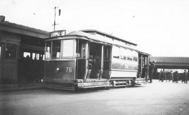
Photograph - Black & White Photograph/s, Lee A Ratten, c1925
Black and white photograph of tramcar 76 at Batman Avenue terminus in 1925. The tram is a single-truck California combination tram, one of 20 built for the P&MTT in 1915. The photo was taken at Batman Avenue in 1925 and shows a driver or conductor adjusting the trolley pole. The photo shows the Batman Ave terminus and Flinders St station in the background. Tram 76 was built in 1915 by the Meadow Manufacturing Co in Sydney for the Prahran and Malvern Tramways Trust before transferring to the MMTB in 1920. The J-class tram was bought by the SECV in 1931 and moved to Ballarat as tram No. 19. It operated in Ballarat until it was transferred to Bendigo in 1960 as tram No. 7, operating as public transport until 1972. It is now in operating condition at the Tramway Museum Society of Victoria in Bendigo. Tram 76 has the destination of Chapel St. Tram 76 was allocated at the Glenhuntly depot as at 24 March 1928.trams, tramways, batman ave, pmtt, secv, ballarat, bendigo, shelters, chapel st, tram 76, j class, mmtb -
 Eltham District Historical Society Inc
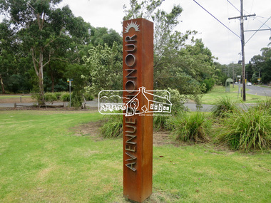
Photograph, Jim Connor, Avenue of Honour, Main Road, Eltham, 14 Jan 2017
Walking or driving up Main Road, you enter Eltham’s Avenue of Honour, with its rows of plane trees, each commemorating the death of a soldier sent to fight in World War 1. 115 trees were first planted on 21st September 1917 beginning at “the flat” to the intersection of Pitt Street. Tree guards and copper name plates were later added. In the ‘20s and ‘30s too many branches were broken off by carriers whipping their horses up the steep slope. In the 1950s many of the original trees were removed for road widening and new plane trees were planted in their place. In June 2015 during the Anzac Centenary, Nillumbik Shire Council dedicated the new Avenue of Honour in the Eltham Gateway. New markers commemorate local soldiers. Tomorrow's history documented todayeltham, jim connor collection, main road, avenue of honour, eltham gateway, commemoration, marker -
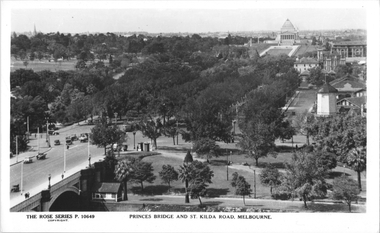 Melbourne Tram Museum
Postcard, Rose Stereograph Co, "Princes Bridge and St Kilda Road Melbourne", late 1930s
Rose Series postcard No. P 10649, titled "Princes Bridge and St Kilda Road Melbourne", looking south from Flinders St station clock tower showing Princess Bridge and St. Kilda Road with a W2 class tram in the view at the intersection of City Road to the west and Alexandra Avenue to the east. In the background is the Shrine of Remembrance. To the west of St. Kilda Road running in parallel from City Road to Mafra Street is Sloss Street, it was removed in the late 1960' for the construction of the National Arts Center. The former "Green Mill" dance hall built in 1926 become the "Forty Club" in 1933 and evolved to being the "Trocadero Palais" by the late 1930's can be seen on the right of the photo. The road on the south side of the Yarra River, at the bottom of the photo, is Riverside Avenue. Yields information about St Kilda Road, late 1930s.Postcard - printed real photograph with Rose Stereograph Co. name on the rear.trams, shrine of remembrance, st kilda road, princes bridge, w2 class, tramways -
 Greensborough Historical Society
Map, Melbourne and Metropolitan Board of Works. Survey Division, MMBW, Yarra 2500 / 13.24. Plenty, Memorial Drive, 1979_03
Melbourne and Metropolitan Board of Works. Yarra 2500 [base map] 13-24. Plenty, Memorial Drive. Parish of Morang 3183. Municipalities of Diamond Valley 257 and Whittlesea 239. Prominent streets include: Oatland Road, River Avenue and Memorial Drive. Includes Plenty River and SEC Transmission easement.MMBW Map in 1:2500 [scale] series. Cream parchment with green tape reinforcing on edges and punched holes on left edge.mmbw, melbourne and metropolitan board of works, shire of diamond valley, plenty - maps -
 Ringwood and District Historical Society
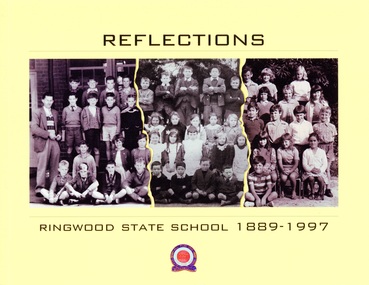
Book, Reflections - Ringwood State School 1889-1997
This book was created for the centenary celebration of the Ringwood State School No. 2997, located on Greenwood Avenue, Ringwood, Victoria. Construction began on the new building in 1921. The building centenary celebration was held at that site, now Maroondah Federation Estate, on 12th November, 2022, a year later than expected due to the Covid epidemic.Collage of students' class photographs and Ringwood State School logo on front of yellow soft-cover book, containing multiple contributors' photographs and written memories.Acknowledgements: First and foremost, the people who provided personal stories are to be congratulated, having contributed intimate memories and photographs. This is their book. Contributors include: Russ Haines Thomas Guest Bill Adolphson Lindsay Adolphson Kerri Kirby (Mathieson) Glenda Oliver (Pottenger) Ian McCleave Dawn Rees (nee Riedel) Linda Cuthill Russ Read Marie Gribben Sir Ronald East Jennie Roe Coral Powell Liz Seaton Stan Mathieson Alan Rittman Denise (White) Wilson Ian Wilton Neville Burns Marion Tremlett (nee Hayward) Gavin Fry Lynette Broadway-Hill James Rogers Suzanne Strout (nee Rogers) Patricia Rogers Peter Fry Malcolm Hugh Powell -
 Whitehorse Historical Society Inc.
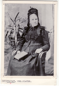
Photograph, Mrs. Slater
Mrs Slater and her husband William Slater migrated from Mitcham, Surrey, England in 1855 and established a herb farm in Nunawading - the first in Victoria. The farm was located in Blackburn Road, North Blackburn. When Mrs Slater died in 1895 the farm was sold. Slater Avenue and Slater Reserve is named for them.3 copies of Black and white photo of Mrs. Slaterslater, william, mrs, herb farms, slater avenue, blackburn north, slater reserve -
 Whitehorse Historical Society Inc.
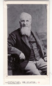
Photograph, William Slater
Mrs Slater and her husband William Slater migrated from Mitcham, Surrey, England in 1855 and established a herb farm in Nunawading - the first in Victoria. The farm was located in Blackburn Road, North Blackburn. When Mrs Slater died in 1895 the farm was sold. Slater Avenue and Slater Reserve is named for them.4 copies of black and white photo of William Slaterpioneers, slater, william, herb farms, slater avenue, blackburn north, slater reserve -
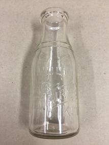 Kew Historical Society Inc
Container, Model Dairy, Milk Bottle, Twentieth Century
The Model Dairy was founded by the Kew pioneer, James Venn Morgan. The dairy had a number of different locations in Kew depending on the time period. Its final incarnation was on the north side of Cotham Road, between Ridgeway Avenue and Kent Street, Kew. The final factory was designed by the architects Bates, Smart and McCutcheon.Kew was a major milk producing district in the Nineteenth and early Twentieth centuries, with three major dairy farms lining the Yarra between Studley Park in the west and Burke Road in the east. In addition to these dairy producers, there were also a number of accredited dairy retailers in the suburb. The largest and most enduring of these was the Model Dairy founded by the Kew pioneer James Venn Morgan. Milk bottles that include the name of the producer or retailer are historically significant as they represent a period in Kew's history before the mass production of milk in the second half of the Twentieth Century. A number of these named bottles have the additional attribute of rarity.Milk bottle - Model Dairy Kew. Pressed inscription: "Model Dairy Ltd Kew." Reverse: " This bottle contains milk bottled for sale by Model Dairey Ltd and always remains their property. It is loaned & cannot legally be used by others. One Imperial Pint. This bottle differs from 1981.0010 in that it has two pressed rings on the neck of the bottle.milk bottles, model dairy (kew) -
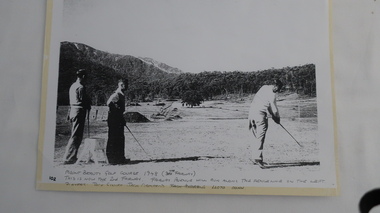 Kiewa Valley Historical Society
Photo - Golfers at Mt Beauty Golf Course
This photograph is one of the first photos of golfing in Mt Beauty. It is dated 1948 and it pictures three high-profile Kiewa Hydro Electric Scheme staff members having a hit of golf on a rudimentary course which was the fore runner to the beautiful golf course we enjoy today. This photo may have been published in one of the SECV magazines.Jack Giniff, Jack Ormerod and Lloyd Dunn were well known on the K.H.E.scheme. The photo shows how quickly community facilities were organised to provide sporting opportunities for the 4000+ workforce.Photo of 3 men playing golf copied from the original onto photo-quality paper in an enlarged form.Hand written at the bottom of the photo: "Mount Beauty Golf Course 1948 (7th Fairway). This is now the 2nd Fairway. Fairway Avenue will run along - the fenceline on the left. Players: Jack Giniff, Jack Ormerod, Lloyd Dunn." Note: "Jack Andrews" crossed out.golf at mt beauty, sport and recreation -
 Ringwood and District Historical Society
Photographs, 1979-80 MMBW pipe line project at Hubbard Reserve, North Ringwood � Truck-mounted posthole digger that tried to sink shafts on MMBW sewer line behind 29-39 Burlock Avenue
Part of a 43-photo record of the MMBW�s engineering feat in drilling a 12 inch pipe line up to 40 feet deep through rock hardened by volcanic action associated with geological fault that occurs along the line. The work took place from October 1979 to May 1980 on the southern boundary of Hubbard Reserve, North Ringwood. The collection was presented to the Ringwood Historical Research Group by J Clarke on 9th June 1980.E560 N32 Feb 1980 A43 Truck-mounted posthole digger that tried to sink shafts on MMBW sewer line behind 29-39 Burlock Avenue. Four feet wide, the auger could only go down one metre and was nearly useless. -
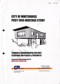 Whitehorse Historical Society Inc.
Book - Heritage Study, City Of Whitehorse Post-1945 Heritage Study, 4 March 2015
City of Whitehorse Post-1945 Heritage Study, dated 4 March 2015A4, 285 pages. A draft copy of the City of Whitehorse Post-1945 Heritage Study, dated 4 March 2015 (on front page) plus published copy of Appendix 2 pages 275-285non-fictionCity of Whitehorse Post-1945 Heritage Study, dated 4 March 2015 city of whitehorse, post war buildings, built heritage pty ltd, historic buildings, post war development, houses, architectural styles