Showing 10466 items
matching plan
-
 Port Melbourne Historical & Preservation Society
Plan - Alternative SCDC plan for Bayside development, Port Melbourne, Barry Merat, Foreshore Use, 1987
Display item used during public information sessions conducted in 1987 by the Port Melbourne City Council's Community Committee (Brenda BEDFORD, Frank CALLAGHAN, Ron WEST and Barry MERAT) regarding SCDC Bayside Development.Sketched plan illustrating alternative to SCDC plan for Bayside development.town planning - proposals shelved - bayside, public action campaigns, sandridge city development co pty ltd, scdc, brenda bedford, frank callaghan, ron west, barry merat -
Clunes Museum
Drawing - ARCHITECTURAL DRAWINGS, TERENCE CAREY ARCHITECTS P/L
COLLINS PLACE, CLUNES. PUBLIC AMENITIES AND ROTUNDA PLANSARCHITECTURAL DRAWINGS. PLANS AND SPECIFICATIONS OF PUBLIC AMENITIES AND ROTUNDA, COLLINS PLACE CLUNES. 7 PAGES STAPLED. MAY 2009buildings, clunes, collins place -
![Documents, 25th Anniversary 1986-7. [Watsonia High School], 1986-1987](/media/collectors/4f729f5697f83e03086015b8/items/52bbe7b32162ef1794893c37/item-media/52bbe9042162ef1794893db3/item-fit-380x285.jpg) Greensborough Historical Society
Greensborough Historical SocietyDocuments, 25th Anniversary 1986-7. [Watsonia High School], 1986-1987
1987 marked the 25th anniversary of the opening of Watsonia High School. Mrs Margaret Willimott was appointed chair of the committee organising the celebrations. These are her personal notes on the planningPersonal documents tend not to survive over time. These documents record both activities and people involved.A collection of planning documents and advertising materials, in manila foolscap folder. Typed and handwritten. In black felt pen on front cover “25th Anniversary 1986-7”watsonia high school, 25th anniversary, margaret willimott -
 Ringwood and District Historical Society
Newspaper, Scrapbook Clipping, Library Collection, Ringwood, Victoria
Newspaper Clipping from "The Mail", 17-12-96, Page 5 . 'Sports plan is rejected' - By Jamie DuncanMaroondah Council has knocked back Yarra Valley Anglican School's plans to build an indoor sports complex on its Kalinda Rd site. Nearby residents were concerned abou the potential noise and visual impact of the stadium. -
 Kew Historical Society Inc
Plan - Subdivision Plan, Belford Heights Estate, Kew, ca. 1925
Pru Sanderson, in her groundbreaking ‘City of Kew Urban Conservation Study : Volume 2 - Development History’ (1988), summarised the periods of urban development and subdivisions of land in Kew. The periods that she identified included 1845-1880, 1880-1893, 1893-1921, 1921-1933, 1933-1943, and Post-War Development. These periods were selected as they represented periods of rapid growth or decline in urban development. An obvious starting point for Sanderson’s groupings involved population growth and the associated economic cycles. These cycles also highlighted urban expansion onto land that was predominantly rural, although in other cases it represented the decline and breakup of large estates. A number of the plans in the Kew Historical Society’s collection can also be found in other collections, such as those of the State Library of Victoria and the Boroondara Library Service. A number are however unique to the collection.The Kew Historical Society collection includes almost 100 subdivision plans pertaining to suburbs of the City of Melbourne. Most of these are of Kew, Kew East or Studley Park, although a smaller number are plans of Camberwell, Deepdene, Balwyn and Hawthorn. It is believed that the majority of the plans were gifted to the Society by persons connected with the real estate firm - J. R. Mathers and McMillan, 136 Cotham Road, Kew. The Plans in the collection are rarely in pristine form, being working plans on which the agent would write notes and record lots sold and the prices of these. The subdivision plans are historically significant examples of the growth of urban Melbourne from the beginning of the 20th Century up until the 1980s. A number of the plans are double-sided and often include a photograph on the reverse. A number of the latter are by noted photographers such as J.E. Barnes.The Belford Heights Estate was a subdivision in Kew East, even though the title of the plan indicates that it was located in Kew. The subdivision had been approved by 1915, and included 105 lots facing Strathalbyn, Kitchener, Hamilton and Beresford Streets, as well as Balfour and Belford Roads. Those lots hand coloured with red probably represent blocks that had been sold. The additional information provided on the plan is also of interest. The plan includes the original location of East Kew State (Primary) School in Strathalbyn Street, which opened in 1892. The inset Locality Plan also includes the route of the Outer Circle Railway and the location of the Wilsmere and East Kew Stations. The location of the landmark Harp of Erin Hotel is also marked on the Locality Plan.belford heights estate, subdivision plans - kew -
 Kew Historical Society Inc
Plan - Subdivision Plan, J Hurrey, Section 115 in the Parish of Boroondara Near Richmond Bridge, 1853
Despite the plans claims that it is a subdivision near the Richmond Bridge, Section 115 was located at what is now Camberwell Junction. While the plan only lists government roads rather than named streets, the section was located on the east side of Burke Road, stretching up the hill from the current Junction. Research on Trove, conducted by Kerry Fairbank, discovered an advertisement for unsold lots in Section 115 which clarifies the extent and location of subsequent land sales in the original section. The original article can be viewed through the link in the catalogue record. The interesting link to Kew is the reference to James Beavan as the purchaser of lots 14 and 15. The historian Gwen McWilliam has notes that a Mr Beavan changed his name from Bevan. The Bevans were descendants of the Derricks family of Kew. This subdivision plan is the earliest original map or plan in the collection which shows parts of what is now the City of Boroondara, dating from circa 1853. It provides important information for researchers on subsequent subdivisions following the original land sales in [Camberwell] Boroondara. The site, on the east side of Burke Road is a highly-significant and historic site. This is believed to be the only extant copy of the subdivision in public collections.A small plan on parchment listing 28 lots, between one and two acres each, for sale in Section 115 in the Parish of Boroondara, dating from 1853 when the portion was subdivided.Obverse: Lot 16 "Joseph Duval", Lots 14 & 15 "James Beavan". Other annotations (measurements) are unreadable. Reverse: "KH-981 / Section 115 in the Parish of Boroondara / Near Richmond Bridge / 1640T. / J Duval / 14-15 J. Beavanparish of boroondara, subdivision plans - camberwell, section 115 - boroondara, subdivision plans -- camberwell (vic), riverscape road, burke road, camberwell junction -
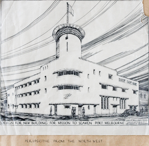 Mission to Seafarers Victoria
Plan - Architectural Plan, Louis Reginald Williams, Plans for the Port Melbourne Mission to Seamen by Louis R.Williams of F.R.A.I.A Architect, c. 1936
In 1936, the old Port Melbourne building dating from 1888 was too small and not longer suitable for the purpose of the mission. So architects were asked to design a new building. Harry Morris 's project was chosen.Louis Reginald Williams (1890–1980) was s sought after ecclesiastical architect in Australia. He designed churches throughout the country, particularly in Victoria. The Anglican Church was his major client but he also Methodists, Presbyterians, Lutherans and Christian Scientists churches. Williams was probably the major church architect in Australia in the Arts and Crafts tradition from the 1920s to the 1970s.Plans port melbourne, louis reginald williams, louis reginald williams (1890–1980), arts and crafts, art deco, harry norris -
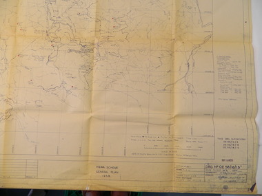 Kiewa Valley Historical Society
Plan - Kiewa Scheme General Plan 1958, S.E.C.V. Design & Construction Dept. Civil Branch, Dec. 1958
The Kiewa Hydro Electric Scheme was constructed by the State Electricity Commission of Victoria. Draftsmen drew up the plan of the layout as per the instructions from the engineers. The plan was drawn up on a transparency sheet and paper prints run off on a 'dyeline' copier. The 'Chief draftsman' and 'Design engineer' and 'Civil engineers recommended it and approved it. Historic: This plan gives a time line for the work on the Kiewa Hydro Electric Scheme. It is a good example of the work of a draftsman and the copying process in 1958.Large topography map of the area covered by the Kiewa Hydro Electric Scheme in 1958. Mountain peaks are marked in red and named. Rivers, roads, construction infrastructure as well as the main areas / names of construction are named. Signed and dated by employees of the S.E.C.V. working on the scheme.state electricity commission of victoria., kiewa hydro electric scheme, plan, engineer, draftsman -
 Kew Historical Society Inc
Plan - Subdivision Plan, Shop Sites, East Kew, c.1927
Subdivision plans are historically important documents used as evidence of the growth of suburbs in Australia. They frequently provide information about when the land was sold on which a built structure was subsequently constructed as well as evidence relating to surveyors and real estate and financial agents. The numerous subdivision plans in the Kew Historical Society's collection represent working documents, ranging from the initial sketches made in planning a subdivision to printed plans on which auctioneers or agents listed the prices for which individual lots were sold. In a number of cases, the reverse of a subdivision plan in the collection includes a photograph of a house that was also for sale by the agent. These photographs provide significant heritage information relating house design and decoration, fencing and household gardens.This is one of a small number of subdivision plans for commercial property in the collection. The subdivision proposed to create six shop sites in High Street between the Harp of Erin and Station Street. The plan shows this stretch of High Street, East Kew already lined with shops that include the hotel on the corner, the new State Savings Bank, a dentist’s surgery and Lambert’s Store. The High Street Tram was to reach Burke Road in 1925, so the proposed subdivision must postdate that event, and the opening of the Bank in 1926.subdivision plans - east kew, high street - east kew -
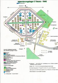 Tatura Irrigation & Wartime Camps Museum
Drawing, Internment Camp 3 Tatura as in 1945, January 1992
Plan of Camp 3 Tatura layout as in 1945. Camp contained members of Palestine, Singapore/Straits Settlement & New Guinea Groups.Laminated coloured A4 plan showing layout of buildings and perimeter fencing of camp 3 Tatura. palestine group, singapore group, new guinea group, camp 3 layout -
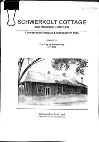 Whitehorse Historical Society Inc.
Book - Schwerkolt Cottage and Museum Complex, April 2002
A Conservation Analysis & Management Plan prepared for the City of Whitehorse. April ,2002Conservation Analysis & Management Plan of Schwerkolt Cottage & Museum ComplexA4, 97p bulldog clipped Conservation Analysis & Management Plan prepared for the City of Whitehorse by Summerton & Wixted . April 2002schwerkolt cottage & museum complex, historic buildings -
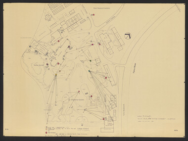
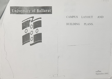 Federation University Historical Collection
Plan, University of Ballarat Campus Layout and Building Plans September 1995
University of Ballarat is a predecessor of Federation UniversityA3 pages with plans of University of Ballarat Campus layout and building plans With Compliments Slip from Prof. P. Candybuilding plans, university of ballarat, campus layout, prof. p candy, with compliments -
Port Melbourne Historical & Preservation Society
Plan - Council Chambers, Borough of Sandridge, Borough of Sandridge, Mar 1861
1861 Plan for the Borough Council Chambers, Sandridge, showing "elevation" and "plan"."Frederick William Bull, Municipal Surveyor" (Sandridge March 28th, 1861)local government - borough of sandridge, built environment - civic, frederick william bull -
 Surrey Hills Historical Society Collection
Book, Medlow Garden Survey and Landscape capability study 1983, Oct-83
Includes: Plan of Subdivision, Detailed plan, map of garden, Auctioneer's plan for 1854 sale, Botanical plan of Medlow & Landscape history notes. Full title : Medlow Garden survey and landscape capability survey. A report for the National Trust of Australia (Victoria) A report giving a detailed landscape survey of Medlow Garden estate. Includes landscape story, cultural significance, particulars about vegetarian, garden, rehabilitation and plans.Copy of a report giving a detailed landscape survey of Medlow Garden estate. Includes landscape story, cultural significance, particulars about vegetarian, garden, rehabilitation and plans. 38 pages with illustrations.land surveys, medlow garden, bismark estate, rosalie estate, warrigal road, surrey hills, bismarck avenue, warwick avenue, t p payne, (mr) hugh glass, boroondara, (mr) (maj) - cairncross, (mrs) mary jane cairncross, (dr) (mr) richard joseph bull, (mrs) catherine grace bull, (miss) norma bull, (mr) ronald richard bull, medlow -
 University of Melbourne, Burnley Campus Archives
Plan, VCAH -Burnley: Sluice Valve, Tap & Fire Hydrant Locations, c. 1987
Plan showing locations and instructions for use, hand drawn. "Overlay onto SP1 Plan 1/1987," handwritten on it. Plan same as 11.0715.vcah, sluice valves, taps, fire hydrants -
University of Melbourne, Burnley Campus Archives
Document, Victorian College of Agriculture and Horticulture, Pruning Garden, 1995
pruning garden, field station, orchard, vcah burnley, horticultural resources area, student gardens, ground cover plots, students working poutside, plan -
Port Melbourne Historical & Preservation Society
Plan - Port Melbourne Yacht Club, John Adam, Architect, 1960s
Plans for Port Melbourne Yacht Club new dinghy building 1962. .01 Storage layouts - sketch plan .02 Plan of new dinghy building .03 Location and pile plan .04 Working drawing - site elevations .05 Working drawing - plan view sport - yachting, built environment - recreational facilities -
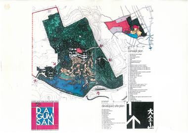 Bendigo Historical Society Inc.
Document - Dai Gum San Concept Plans - Chinese Tourist Village Bendigo Victoria, 1980s
During the first goldrush of the 1850s, Chinese miners referred to the Bendigo region (then Sandhurst) as Dai Gum San 大金山 - literally 'Big Gold Mountain'. The Golden Dragon Museum is situated in the city of Bendigo, Victoria, Australia. The museum is dedicated to the culture and history of Chinese Australians, particularly in the region. Built on the historical site of one of Bendigo's Chinatowns, the museum's precinct also includes Chinese Gardens and a temple to Kuan Yin. Through the museum accreditation program, it was the first accredited museum in Victoria and opened in 1991. These plans are the original plans before the the Golden Dragon Museum was built on its current site.Dai Gum San Concept Plans - Chinese Tourist Village Bendigo Victoria - 4 Sheets in colour by Stephenson and Turner Victoria Architects and Planners Sheet 1 Concept Plan and Developed Site Plan Sheet 2 Arts and Crafts Buildings Sheet 3 Restaurant, Historical Museum and Temple Complex Sheet 4 Motelhistory, bendigo, eaglehawk, chinese, chinese museum, dai gum san -
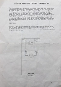 Kew Historical Society Inc
Document, Pru Sanderson Design Pty Ltd, History and Description of 'Glencara', Sackville Street, 1984-1988
History, description, site plan and house plan of 'Glencara' at 59 Sackville Street, Kew.2-page document with site plan and internal layout of Glencara (b.1893,) 59 Sackville Street, Kew. The text in the document is identical to that in Pru Sanderson's Kew Conservation Study (1988).glencara -- sackville street -- kew (vic), houses -- sackville street -- kew -
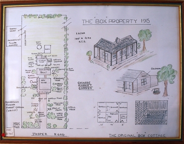 City of Moorabbin Historical Society (Operating the Box Cottage Museum)
Drawing - Plan of Box Property c1915, c1985
This ‘Plan of the Box Property c1915’ was drawn by a CMHS member in 1985 to educate members and visitors to Box Cottage Museum. The drawing shows the layout of the original pioneer cottage , the newer front house and the garden as well as the adjoining properties. It includes a detailed drawing of the Cottage roof and rooms . A coloured drawing of a Plan of Box Property c1915 in a wooden frame box william, box elizabeth, brighton, cheltenham, moorabbin, pioneers, early settlers, market gardeners, ormond -
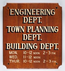 City of Greater Bendigo - Civic Collection
Sign - Municipal Departments Opening Times
History of this item is unknown but was used by one of the City, Shire or Borough Council's to advertise various department opening hours.Sign constructed from four pieces of wood. Hand painted text advertising engineering, town planning and building departments opening days and times.ENGINEERING / DEPT. / TOWN PLANNING / DEPT./ BUILDING DEPT. / MON. 10 - 12 NOON 2 - 3 PM / WED. 11 - 12 NOON / THUR. 10 - 12 NOON 2 - 3 PMcity of greater bendigo signs, city of greater bendigo administration item -
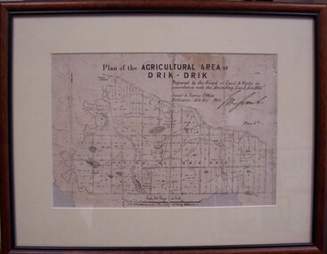 Glenelg Shire Council Cultural Collection
Map - Map of Drik-Drik, 1865
Displayed at History House.Print of map pasted onto board, mounted and framed under glass. Buff-coloured mount. Mahogany stained moulded wood frame, black inner frame.Front: Plan of the Agricultural Area of Drik-Drik L.2556/Prepared by the Board of Lands and Works in accordance with the "Amending Land Act 1865". Lands and Survey Office, Melbourne 11th May 1865. (printed, upper centre). Back: Duncan Hedditchmap, drik drik, plan, geography, cartography -
Bendigo Historical Society Inc.
Plan - MARKS COLLECTION: PLAN FOR ADDITIONS TO FORTUNA VILLA FOR GEO. LANSELL ESQ. - STAIRCASE ADDITION
Plan for the addition and necessary modifications of a staircase to Fortuna Villa, the residence of George Lansell Esq. Coloured plan Plan is damaged missing several sections on the LHS of the plan and has water damage in lower LH corner -
University of Melbourne, Burnley Campus Archives
Plan, Ian Robertson, Student Gardens Burnley Campus, 1989
Plans on tracing paper by Ian Robertson. Scale 1:50. 1. Planting Plan, Sheet No 5, 19.5.89. 2. Master Plan, Sheet No 6, 6.6.89. 3. Preliminary Plan Sheet No 4, 19.5.89.ian robertson, burnley campus, student gardens -
Port Melbourne Historical & Preservation Society
Plan - Proposed extensions, Heath Street, Port Melbourne Town Hall, E J Pembroke, 15 Oct 1936
Floor plans, elevations to Heath street; south end; roof plan for proposed extensions to supper room Town Hall 1936. Coloured plans."City of Port Melbourne . Proposed Extensions to Supper Room . Town Hall"port melbourne town hall, pembroke and turner, e j pembroke -
 Kew Historical Society Inc
Plan - Subdivision Plan, Corsewall Estate, 1938
The Kew Historical Society collection includes almost 100 subdivision plans pertaining to suburbs of the City of Melbourne. Most of these are of Kew, Kew East or Studley Park, although a smaller number are plans of Camberwell, Deepdene, Balwyn and Hawthorn. It is believed that the majority of the plans were gifted to the Society by persons connected with the real estate firm - J. R. Mathers and McMillan, 136 Cotham Road, Kew. The Plans in the collection are rarely in pristine form, being working plans on which the agent would write notes and record lots sold and the prices of these. The subdivision plans are historically significant examples of the growth of urban Melbourne from the beginning of the 20th Century up until the 1980s. A number of the plans are double-sided and often include a photograph on the reverse. A number of the latter are by noted photographers such as J.E. Barnes.The Corsewall Estate was a subdivision, bordering on Barkers Road and Auburn Road, which created Corsewall Close. This relatively late subdivision included 29 allotments. The subdivision plan includes the dimensions of each lot as well as the width of the existing and projected roads and turning circles. The Corsewall Close Precinct is now listed on the Victorian Heritage Database (HO147) and is noted for its ‘consistent flat-type development over the entire street, which has been cleverly designed to make multi-unit dwellings appear as single buildings’.subdivision plans - hawthorn, corsewall estate -- hawthorn (vic.) -
Whitehorse Historical Society Inc.
Pamphlet, Creating a New Strathdon Community, 2001
Creating a New Strathdon Community.Creating a New Strathdon Community: A vision for the redevelopment of Strathdon's Jolimont Road site, contains Plans of Proposals for site development.Creating a New Strathdon Community.strathdon community, strathdon orchard, matheson, charles, matheson mary, aged people -
Whitehorse Historical Society Inc.
Document, Blackburn Road Rail Crossing Removal Project, 2012
Information update issued by VicRoads.Information update issued by VicRoads regarding the planned removal of the rail crossing at Blackburn Road, and improvements to the Blackburn Railway Station.Information update issued by VicRoads.blackburn railway crossing, blackburn railway station, blackburn road, blackburn -
Whitehorse Historical Society Inc.
Pamphlet, Blackburn Lake Sanctuary : Past, present and future, c1985
Descriptive pamphlet outlining the history of the Sanctuary up to 1980.Descriptive pamphlet outlining the history of the Sanctuary up to 1980. A detailed description of the geomorphology, vegetation and fauna is given and an outline of plans for the future.Descriptive pamphlet outlining the history of the Sanctuary up to 1980. blackburn lake sanctuary, past -
Port Melbourne Historical & Preservation Society
Plan - Lyons Street, Port Melbourne, Borough of Sandridge, 9 Oct 1877
Plan of Lyons Street, showing longitudinal section, ground plan and transverse section.Minehan, Michael:Clark, Edward C (Town Clerk)engineering - roads streets lanes and footpaths, michael minahan, edward clark, town clerks