Showing 13587 items
matching hall street
-
 Glenelg Shire Council Cultural Collection
Photograph - Photograph - Soil Erosion Casterton, n.d
Sourced from Casterton Town Hall (Former Shire of Glenelg))Black and white photo. Man standing near culvert under road, shows erosion of banksBack: Round, purple, photographer's stamp -
Glenelg Shire Council Cultural Collection
Photograph - Photograph - Glenelg Shire Council administration staff Casterton Victoria, c. 1963
Sourced from Casterton Town Hall (former Shire of Glenelg)Black and white photo. Administration staff at Shire of Glenelg, Casterton Victoria. -
Glenelg Shire Council Cultural Collection
Photograph - Photograph - Erosion, Casterton, Victoria, n.d
Sourced from Casterton Town Hall (Former Shire of Glenelg)Black and white photo. Erosion near Casterton.Back: Purple, round, photographer's stamp -
Glenelg Shire Council Cultural Collection
Photograph - Photograph - Casterton, Victoria, n.d
Sourced from Casterton Town Hall (Former Shire of Glenelg)Black and white photo. Outskirts of Casterton -
Glenelg Shire Council Cultural Collection
Journal - Notes, c. 1974
K.S. Anderson Collection7 hand written pages of notes for original address - opening of Civic Hall, 26 March 1974.civic hall -
Glenelg Shire Council Cultural Collection
Photograph - Photograph - Casterton, Victoria, n.d
Sourced from Casterton Town Hall (Former Shire of Glenelg)Black and white photo. View of residential area of CastertonBack: Black stamp - 003755 -
Glenelg Shire Council Cultural Collection
Photograph - Photograph - Casterton, Victoria, c. 1963
Sourced from Casterton Town Hall (Former Shire of Glenelg)Black and white photo. View of Casterton, residential areaBack: Black stamp - 003755 -
Glenelg Shire Council Cultural Collection
Photograph - Photograph - Casterton, Victoria, c. 1963
Sourced from Casterton Town Hall (Former Shire of Glenelg)Black and white photo, showing pine plantation near CastertonBack: 'Pine plantation near Casterton' - handwritten, pencil. Blue biro line, arrowed each end, drawn across photo. '3" 'above line -
Glenelg Shire Council Cultural Collection
Photograph - Photograph - Casterton, Victoria, n.d
Sourced from Casterton Town Hall (Former Shire of Glenelg)Black and white photo. Erosion near Casterton, man standing near hole in paddockBack: Round, purple, photographer's stamp -
Glenelg Shire Council Cultural Collection
Photograph - Photograph - Casterton, Victoria - Erosion bank, n.d
Sourced from Casterton Town Hall (Former Shire of Glenelg)Black and white photo, same as 7227 (soil erosion, river bank) -
Glenelg Shire Council Cultural Collection
Photograph - Photograph - Casterton Victoria, n.d
Sourced from Casterton Town Hall (former Shire of Glenelg)Black and white photo. Large diameter concrete pipes, man standing beside them. -
Glenelg Shire Council Cultural Collection
Photograph - Photograph - Rural Scene, n.d
Sourced from Casterton Town Hall (Former Shire of Glenelg)Black and white photo. Man from 7212 on side of road with small black and white dog. Car from 7211, 7212 on road. -
Glenelg Shire Council Cultural Collection
Photograph - Photograph - Casterton, Victoria, n.d
Sourced from Casterton Town Hall (Former Shire of Glenelg)Black and white photo. View of Casterton from elevated position. Shows street running through centre of townBack: Black stamp - 001434 -
Glenelg Shire Council Cultural Collection
Photograph - Photograph - Casterton, Victoria, c. 1963
Sourced from Casterton Town Hall (Former Shire of Glenelg)Black and white photo. Same as 7267Back: Black stamp '003826' -
Glenelg Shire Council Cultural Collection
Photograph, n.d
Sourced from Casterton Town Hall (Former Shire of Glenelg)Coloured photograph. Same subject as 7293, different viewBack: 'FIRE PREVENTION DAM CHETWYND' hand printed in blue biro -
Glenelg Shire Council Cultural Collection
Photograph - Photograph - Casterton, Victoria, c. 1963
Sourced from Casterton Town Hall (Former Shire of Glenelg)Black and white photo. Similar to 7278, slightly different view.Back: Black stamp ' 004144' -
Glenelg Shire Council Cultural Collection
Souvenir - Pen - History House Portland, n.d
Pen, biro, brown with gold trimsFront: 'HISTORY HOUSE (OLD TOWN HALL) PORTLAND VIC 3305 -
Glenelg Shire Council Cultural Collection
Photograph - Sheet of 12 contact prints - Various historic Portland buildings and Landmarks, c. 1970
... Street - old Town Hall (l) Opening 3rd Baths... Street - old Town Hall (l) Opening 3rd Baths Photograph Sheet ...Sheet of 12 contact prints of rephotographed photographs. Measurements (a) (e)-(h) (j-i)(b) 3.7 x 55 x 3.7 Framed 5.2 x 44.5 x 4 (a) Looking south across beach at Dutton Way (b) S.S. 'Eumeralla' (c) Construction of railway pier (d) Jackass Fern Gully (e) 'Kingsley' (f) Portland Show (g) North side Julia Street looking west Bank of Australiasia (h) Henty Street looking east from Percy Street (i) Old Post Office (j) All Saints Catholic Church (k) View from Henty Street - old Town Hall (l) Opening 3rd BathsFront: (a) 'Dutton Way 1900 (b) 'S.S. Eumeralla' (c) Construction of Railway Pier (f) Portland Show (h) Henty Street, Portland (i) (B) -
 Halls Gap & Grampians Historical Society
Magazine - Photocopy
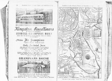
... Conducted Tours, from Hotels and Guesthouses in Stawell and Hall's...Halls Gap & Grampians Historical Society Centennial Hall ...Kingston Roadliners (F. Kingston, Proprietor) STAWELL - GRAMPIANS DAILY Coach for the Grampians meets mid day train at Stawell Return Daily Make the Grampians your next vacation Daily Conducted Tours, from Hotels and Guesthouses in Stawell and Hall's Gap to WONDERLAND - MCKENZIE FALLS - LAKE WARTOOK - MT. VICTORY - MT ROSEA - WANNON VALLEY conducted Hiking Trips Arranged Stawell booking office: 75 Main Street - Phone: Stawell 214, Hall's Gap booking office: Main Road - Phone: Hall's Gap 35, Bookings also from Vitorian Government Tourist Bureau, Cars for hire GRAMPIANS HOUSE The Most Conveniently Situated Tourist House in the Grampians. Ballroom, electric light, large garage, hot water service, hot water in all rooms, internal sewerage. Tennis, fishing, shooting, Alongside is the Bowling Green, where visitors are welcome to play. Phone: Hall's Gap 28. Tariff on application. Manageress: Mrs, E. MatthewsAdvertisement for Kingston Roadliners, Grampians House and Map of the GrampiansAdvertisement in Broadbents, Guide of western Victoria, and South-East of S.A.media, advertisements, grampian house -
 Halls Gap & Grampians Historical Society
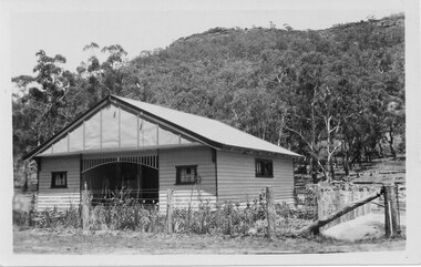
Postcard - B/W, C 1940s
This is the Warren Street residence of the owners of the bakery, which was situated behind this building. The owners were John and Florence Warren who ran the bakery until the 1960's when it was taken over by their daughter Ida and son-in-law Robert Greer. A weatherboard house surrounded by a 'chicken wire' fence. There is a wooded hill in the background.buildings, houses -
 Halls Gap & Grampians Historical Society
Photograph - B/W, C 1987
Ararat pipe band member taking part in the street parade held before the opening of the 1987 Halls Gap Flower Show.The photo is a close-up of a young woman in "Scottish dress" playing the bagpipes. The photo is taken from a position beside and slightly behind the woman."1987 (1) H.G.F.S." written in ink on back.events, wildflower show -
 Halls Gap & Grampians Historical Society
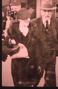
Photograph - Transparency, 1920-1930s
Thomas Morgan and his daughter Nina(Mangel). The Morgan Family purchased Killarney/Grampian House in 1927. Thomas,his wife Sylvia and four children- John,Thomas,Dorothy and Nina ran Grampian House. It was the first guest house in Halls Gap to offer hot and cold running water.A street photographer's photo showing a lady dressed in a fur stole and a suit, she is also wearing a hat, and a man dressed in a three piece suit wearing a hatpeople, morgan -
 Halls Gap & Grampians Historical Society
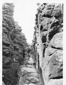
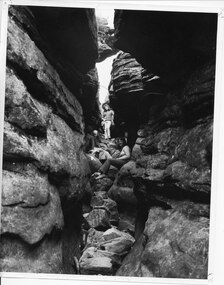
Photograph - B/W, C 1960s
This part of the walking track is known as "Silent Street' and forms part of the Wonderland /Pinnacle track. the photo is typical of those produced by Victorian Railways for tourism.Photo shows walking track through rocky gorge. A step ladder and railings can be seen. A man is walking up the track.scenery, wonderland range -
 Halls Gap & Grampians Historical Society
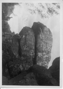
Photograph - B/W, C 1930s
Image is known as 'The Cross' and was in the area of 'Silent Street',part of the walk to the Pinnacle.Photo shows an outcrop of rocks with a 'cross' which has been formed in the rocks.'The Cross in Silent Street, Wonderland.scenery, wonderland range -
 Halls Gap & Grampians Historical Society
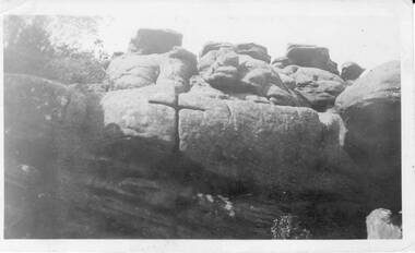
Photograph - B/W, C 1940s -- 50s
Rock formation is called " The Woolpacks " and was located on the Wonderland Track at the top of Silent Street -- however on a Broadbent map of the Grampians no.205 this formation was called the " Wool Sacks " ; and the "Woolpacks" was shown on the map close to Venus Bath.Photo shows distinct slabs of rock balancing on each other. Three people appear in the photo -- a man with a boy and a woman. All three are wearing hats. A large rock outcrop can be seen on right of photos -- trees can be seen on left.The Wool Packs F5030scenery, wonderland range -
 Halls Gap & Grampians Historical Society
Photograph - B/W
the three women appear to be in 'Silent Street', part of the Wonderland Range on the pathway to The Pinnacle lookout.3 young women sitting and standing amongst 2 rock cliffs with tumbled rocks that appear to form steps. a railing can be seen behind standing girl. Clothing is suggestive of the 1970s period.scenery, wonderland range -
 Heathcote McIvor Historical Society
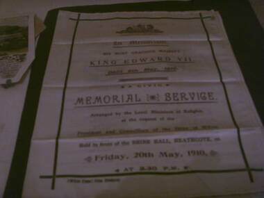
Memorial booklet, shire of mcivor, minsiters of religion, Silk Memorial Booklet Death of King Edward VII 6 May 1910, 06/05/1910-20/05/1910
Created for the memorial service that was held on friday 20th may 1910, held in front of the shire hall in Heathcote to honour king edward VII who died on the 6th may 1910 at 2.30 p.m. this was arranged by the local ministers of religion at the request of the president and councillers of the shire of McIvor.Believed to be the only one in exsistence, after intesive research have been unable to come up with any information, from the shire, local churches or senior members of the community,only mention was in the Bendigo Advertiser newspaper.research in to archives further afield have not produced another.Piece of cream silk printed on face and inside, screen printed in purple and black ink on front and inside the order of service. details of all ministers of religion and shire dignitries as well as hyms sung. "McIvor Times" Print, Heathcote on left hand side below main print. in black inkvictoria, silk memorial booklet, king edward vii, 1910, heathcote, ministers, of, local, churches, shire, president, mcivor, times -
 Ararat & District Historical Society (operating the Langi Morgala Museum)
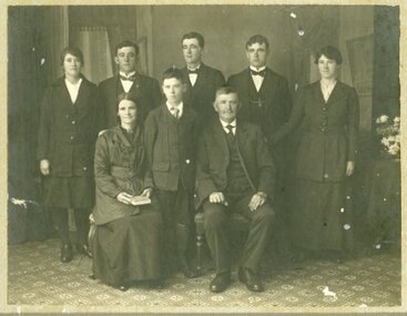
Photograph
Black and white photo of 8 people - 3 females and 5 males. An older couple is seated with a young boy standing between them. All are dressed in formal suits.Written on back: Rita Snibson sec Women's Hospital. Front row: Nell Simpson had a son Jack had a business in Stawell then Melbourne. Nell became Mrs A.J. Sanderson who had a grocery business opposite Town Hall. -
 Ararat & District Historical Society (operating the Langi Morgala Museum)
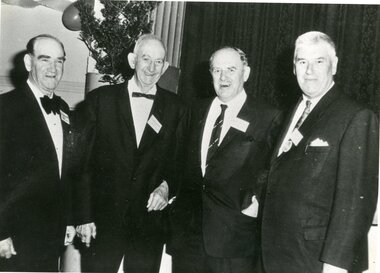
Photograph
Black and white photo of four men in a hall. There is a tree and streamers.On back: Alan Blachford, Arthur Hargreaves -
 Ararat & District Historical Society (operating the Langi Morgala Museum)
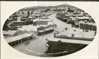
Postcard
Black and white postcard of Barkly Street, Ararat. The photo is taken from the Town Hall. The Commercial Hotel and its balcony are pictured on the right while the zig zag of the main street looks like a dirt road.Addressed to Mr G. Mitchell, Collins St, Melbourne also a letter written on the back of the postcard