Showing 11608 items matching "surveyor-general"
-
 Halls Gap & Grampians Historical Society
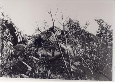
Photograph - B/W
Photo shows rocky outcrops and scrub. A small leafless tree can be seen in centre of photo. Other stumpy trees and grasses also appear in photo.General scrubflora -
 Phillip Island and District Historical Society Inc.
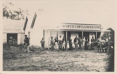
Photograph, 1880's
Photograph from the Bryant West Collection. Copied by Jack Jenner 1968. West General Store was in Thompson Ave, on west side between Chapel Street and The Esplanade. Closer to The Esplanade. Sepia photograph of J & S West Cowes General Store & sheds in Thompson Avenue. Group of people in front and bullock dray. Possibly West family, employees and public. As above with the names.cowes general store phillip island, mary karney, bryant west collection -
 Ballarat Tramway Museum
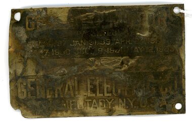
Sign - "GE 69-C-MOTOR PATENTED DEC 4.97 JAN 31 99 APR 24 1900 NOV 7 1900 JUL 9 1901 MAY 12 1903 GENERAL ENGINEERING CO. SCHENECTADY, NY. U.S.A. ?11G4? "
Demonstrates how General Electric Co. used metal makers plates to identify their product, patents, and contact details.Small metal brass coloured makers plate for General Electric Co. Etched background leaves lettering - "GE 69-C-MOTOR PATENTED DEC 4.97 JAN 31 99 APR 24 1900 NOV 7 1900 JUL 9 1901 MAY 12 1903 GENERAL ENGINEERING CO. SCHENECTADY, NY. U.S.A. ?11G4? " There are four holes, one in each corner, to enable attachment to the motor. The model no 69-C has been stamped on at a later date.makers plate for general electric co., motor identification -
 National Wool Museum
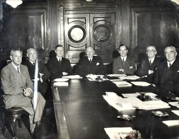
Photograph - General Managers Conference, c.1946
Members at the General Managers Conference, London, around 1946.Black and white photo of 7 men seated around a table in suits. Photo is framed in wooden frame painted silver. Back of the frame has the names of the men written in pen.Back: [handwritten] LEFT TO RIGHT / Mr Wollan Manager Dalgetys East Africa / K. R. ELDER GM Australia / LT. COL. HON. I. LESLIE MELVILLE DIRECTOR / DESMOND ABEL-SMITH CHAIRMAN DALGETYS / G.S. HUNTER GENERAL MANAGER / LONDON / M. STOOKS Secretary / D. COOPER G. MANAGER NZ / General Managers / Conference London / About 1946managers, coference, london, dalgety and company limited -
 Stawell Historical Society Inc
Map, Underground Mine Workings Stawell, 1894
Plan and Elevations of mine workings 12 September 1894. J H Bate Mining Surveyor. Framed under Glassstawell, mining, plans -
 Uniting Church Archives - Synod of Victoria
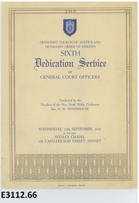
Programme - Methodist Church of Australasia Methodist Order of Knights, Donald F Pettigrew, Methodist Church of Australasia Methodist Order of Knights Sixth Dedication Service 1945, 1945
The service was held on Wednesday, 12th September, 1945 at 8.0 pm Wesley Chapel, 139 Castlereagh Street, Sydney and was conducted by the President of the New South Wales Conference Rev. H. W. Woodhouse.Cream card with blue text with gold border order of service for the Methodist Order of Knights sixth Dedication Service of General Court Officers.non-fictionThe service was held on Wednesday, 12th September, 1945 at 8.0 pm Wesley Chapel, 139 Castlereagh Street, Sydney and was conducted by the President of the New South Wales Conference Rev. H. W. Woodhouse.methodist order of knights, rev h w woodhouse -
 Falls Creek Historical Society
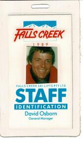
Staff Identification Tag David Osborn 1989
SKI TICKETS Before tows and lifts were introduced at Falls Creek, it could take skiers 20 minutes to climb to the Summit … but only TWO minutes to go back to the bottom. The arrival of tows, then chairlifts and T-bars changed the face of skiing forever. The first rope tow was constructed by Toni St. Elmo for the 1951 winter season. Bob Hymans installed a smaller tow for his guests at Skyline Lodge. Tows were still quite slow, so in 1956 Bob Hymans created his single chairlift. In 1958 the Village rope tow, designed by Albury engineer Jock Wilson, opened. It was financed by shareholders including Bill Griffith (Bowna Ski Club) and the Bridgford family (St. Trinian’s Ski Club). Several other tows followed including the Summit T-bar in 1961, built by Ron McCallum and operated by Alpine Developments Pty. Ltd. which was a company formed by C. H. (Bill) Bridgford. By 1982 Falls Creek was served by 16 different lifts or T-bars, all owned and operated by Alpine Developments (Holdings) Pty. Ltd. During the development of Falls Creek, different methods have been used to pay for the use of tows, lifts and T-bars … including metal tokens, single tickets, strips of tickets and season passes. The Falls Creek Historical Society Collection includes many examples of these items.This Staff Identification Card is significant because it belonged to David Osborn who lead developments at Falls Creek in the late 1980s.A staff identification tag featuring a coloured photograph of David Osborn. He came to Falls Creek to take up the position of General Manager, Falls Creek Ski Lifts Pty. Ltd. He continued in this role until 1990 when he was offered the position of Managing Director at Thredbo. During his period as General Manager major projects carried out at Falls Creek were:- the construction of Halleys Comet Chairlift, Slalom Street Plaza development, the introduction of snowmaking, Cloud 9 Restaurant, the construction of the Scott Chair and the Village Bowl. In 2022 David Osborn released a book, "Falls Creek Stories 1984 - 1990" which documents the developments which occurred in Falls Creek and the people who made them possible.At top: FALLS CREEK 1989 Below photo: FALLS CREEK SKI LIFTS PTY.LTD STAFF IDENTIFICATION David Osborn General Manager chairlift falls creek, david osborn, falls creek development 1980s -
 Ballarat Tramway Museum
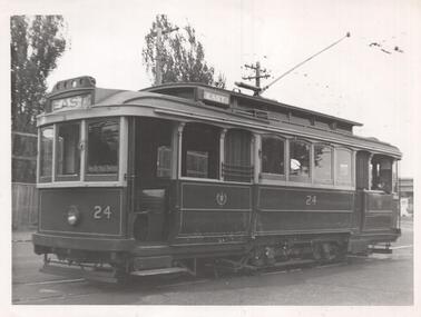
Photograph - Black & White Photograph/s, CLC, 1950
Yields information about Geelong trams in the late 1940's on the Chilwell - East - West lines.Black and White photograph of Geelong No. 24 at the West terminus. Tram has the destination of East. About 1954. Photo by CLC - General Manager of the Wombat Hill Railway,On the rear in pencil "With compliments by General Manager of the Wombat Hill Railway, Printed by the Public Relations Publicity Dept Wombat Hill railway, Geelong No. 24 West terminus about 1950." Has the Keith Kings number "CLC-8" in top right hand corner.trams, tramways, geelong, east, west, tram 24 -
Whitehorse Historical Society Inc.
Map, Ringwood, c1922
Victoria Ringwood Survey map 1 inch to 1 mile.Victoria Ringwood Survey map 1 inch to 1 mile. Covers Eastern suburbs of Melbourne from Richmond to Macclesfield, Heidelberg / Lilydale to Dandenong. Prepared by Commonwealth Section, Imperial General Staff.Victoria Ringwood Survey map 1 inch to 1 mile. eastern suburbs, melbourne, maps -
 Melbourne Legacy
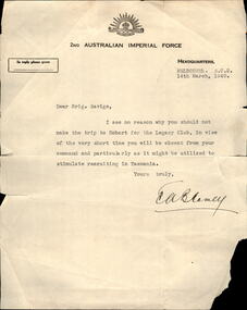
Letter, Permission from Blamey for Savige to travel to Hobart in March 1940, 1940
A letter dated 14 March 1940 to Legatee Stan Savige advising him that he had permission to visit Hobart Legacy while he was in Australia during the second World War. It is signed by General Thomas Blamey. The reason for the trip to Hobart was to present the Legacy Charter to the Remembrance Club to become Hobart Legacy. It was held at Hadley's Hotel in Hobart. Savige was serving in the Second World War and had to obtain special permission to travel to Hobart to fulfil this task. A menu card from the dinner is also in the archive. Legatee Savige presented the Legacy Charter which was then accepted by the President of the Remembrance Club. The members were then presented with Legacy Badges.An important link to Legatee Stan Savige, the founder of Legacy and the acceptance of Legacy Charter in Hobart.Cream letterhead of the 2nd AIF with a letter from General Blamey to Stan Savige in 1940.Signed E A Blamey in black ink.stan savige, remembrance club, hobart, thomas blamey -
 Warrnambool and District Historical Society Inc.
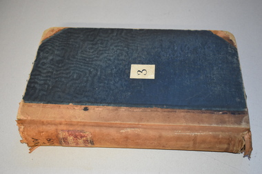
Letter Book 3, 1901 - 1908, 1900
This letter book has letters, plans and maps and dates from 1901 to 1908. It came from the office of John William Crawley, Junior, an engineer, architect and surveyor in private practice in Warrnambool and also the engineer for the Shire of Warrnambool from 1895 to 1935. His father, brother and son were also engineers and worked in that capacity or as the Shire Secretary for the Shire of Warrnambool, with the Crawley family recording a total of 132 years of service to the Shire. The letter book was passed on to John Crawley’s son, Rolf, engineer for the Shire of Warrnambool from 1935 to 1968. The letter book then came into the possession of Michael Hand who took over the private surveying business of Rolf Crawley in Warrnambool. The Warrnambool and District Historical Society has acquired the letter book, one of several Crawley ledgers, from the Michael Hand estate. The Shire of Warrnambool existed from 1863 to 1994. This letter book is of considerable significance as it contains maps, plans and letters produced by John William Crawley Junior, the engineer for the Shire of Warrnambool for 40 years. It will be very useful for research. This is a hard cover letter book of 717 pages. It has a black cover with brown leather binding on the cover edges and spine. The leather is worn away in places. The letter book contains an alphabetical index, handwritten letters, sketch plans and maps. There is a mauve stamp on the inside front cover. ‘3’ ‘Letter Book 1901 to 1908’ ‘Letter Book J.Wm. Crawley’ ‘Rolf L. Crawley, Civil Engineer, Drainage and Water Supply Engineer, Licensed Surveyor, Registered Architect, Warrnambool’ john william crawley junior, warrnambool, rolf crawley, warrnambool, history of warrnambool -
 8th/13th Victorian Mounted Rifles Regimental Collection
Photograph
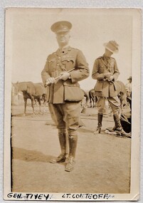
General Tivey served in Boer War and commanded 8th Infantry Brigade AIF in WW1. Post War he commanded 2nd Cavalry Brigade CMF. Part of a collection of photographs taken by unknown photographer serving with 8th Light Horse in Middle East 1916-1918.Black and white photograph of two officers in front of horse lines. In foreground is Major General Edwin Tivey. Other officer cannot be positively identified . " Gen Tivey Lt Col Teaff" -
 Bendigo Military Museum
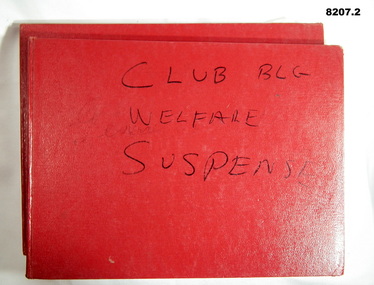
Financial record - ACCOUNT BOOKS BRSL, Bendigo RSL Sub Branch, 1975 - 1982
Income and Expenditure Account books for the Bendigo RSL Sub Branch. .1) Three Acc's are listed, General Acc 1975 - 1979, Club Building 1980 - 1982, Relief Patriotic 1980 - 1982. .2) Three Acc's are listed, Relief Acc 1975 - 1979, Club Building 1977 - 1979, General Acc 1980 - 1982..1) Book, Red cover, blue ruled lines with red and blue vertical lines, entries in blue pen, a small amount in red. Inside the front cover pasted in a large yellow envelope with two copies of different cheques to a local Football Club 1980, one letter from ANZ bank re a new term investment 1980. .2) Book, red cover same as .1) and same lines and entries. .1) On front cover in black texta, "Club Bldg, Welfare, General, suspense" .2) On front cover in black texta faded, "Relief, Club, Suspense"brsl, smirsl, account -
 Orbost & District Historical Society
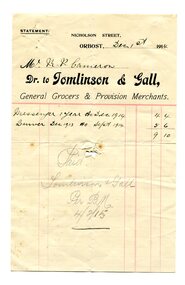
account, December 1st, 1914
Tomlinson & Gall were general grocers and provision merchants in Nicholson Street, Orbost. Robert Pullar Cameron was a Shire Councillor for many years. He married Penuel Hossack and had a family of James, Flora, Penuel and Alex.This item is an example of book-keeping for a business in Orbost in the early 20th century. It is a useful research tool.A white paper account with black print and red lines. It is a hand-written account to R.P. Cameron from Tomlinson & Gall, general grocers and provision merchants in Orbost.account book-keeping cameron-r.p. tomlinson-gall -
 Bendigo Historical Society Inc.
Map - PLAN GENERAL SURVEY MALMSBURY PORCUPINE INN, FOREST CREEK TO GOLDEN POINT. ALEXANDRA RANGE 1853
Colour Copy of Plan of the General Survey from the Town of Malmsbury to the Porcupine Inn, from the sources of Forest Creek to Golden Point, shewing (sic) the Alexandrian Range also Sawpit Gully Bendigo and Bullock Creeks. Handwritten note under the title a follows '' Forwarded to the Colonial Secretary with my letter No A 53/105 dated 30th March 1853 for transmission to the Geological Surveyor. R Hoddle Surveyor General. ' Stamped by Department of Mines Victoria with record#123 in Top right Hand corner. Also contains a catalogue number 2053/M/2. Part of the Contents of a DVD entitled 'Mapping Great Change' - Archival Maps, produced to support an exhibition in the Post Office Gallery Bendigo. A description of the Map, its history and implications for both historical and future discussions is contained in an Essay 'Mapping Great Changes' : The landscape of central Victoria by Gerry Gill.R. Hoddlemap, bendigo, country lands -
 Warrnambool RSL Sub Branch
Hat, Hard Yakka, 2015
This hat is part of a General Purpose Uniform issued by the Australian Airforce to Bernard Farley during service. This uniform type was developed in 2014 and replaced camouflage as the uniform worn during general base duties and in non-warlike environments. Although a camouflage pattern, this design is not intended for use as camouflage. This item has social significance, as an item of uniform worn by Warrnambool RSL community member and Secretary (2019), Bernard Farley during service with the Australian Airforce. The item is a representative example of current Airforce General Purpose Uniform and is in excellent condition. As a set, the uniform has aesthetic significance in it’s design, incorporating GPU uniform design from the Army alongside the colours and motifs of the Australian Airforce. General Purpose Uniform (GPU) hat in Airforce colours of blue and grey in camouflage pattern. Broad brim hat with black plastic cord end fastener on a blue cotton cord. Plastic tag on interior of hat lining with printed inscriptions.Inscription on tag: “Hard Yakka/AUSTRALIA/AUGUST 2015/PO No: CC2XZ8/LAY No: 10609/SQNCOR FARLEY/(broad arrow)/[Mobile Phone Number]/NSN: 8415-66-161-4051/SIZE: M 56cm/NAME:” Inscription on reverse of tag: “PM KEYS No:/75% COTTON/25% POLYESTER/CARE INSTRUCTIONS/HAND WASH IN COLD/WATER WITH MILD/DETERGENT RISE/WELL DO NOT WRING/TUMBLE DRY OR/DRYCLEAN (X)/DRIP DRY IN SHADE”camouflage, airforce, uniform, general purpose uniform, australian defence force -
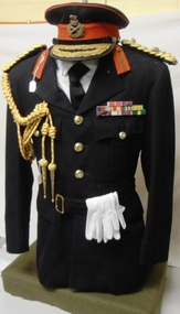 8th/13th Victorian Mounted Rifles Regimental Collection
Uniform - Honorary Colonel Hammer, 1950 circa
This tunic and cap were worn by Major General H H (Tack) Hammer CBE DSO & Bar, ED when Honorary Colonel 8th/13th Victorian Mounted Rifles Regiment 1959-1960 Hammer had pre-WWII service with 8th Battalion and 17th Light Horse (Machine Gun) Regiment. He served with the 6th Division in North Africa and Greece before becoming Commanding Officer of 2nd/48th Battalion. On return from the Middle East, Hammer commanded the 15th Brigade throughout two years of fighting in New Guinea and Bougainville. After the war, Hammer became Commissioner for Repatriation in Victoria and continued his military career in the Citizens Military Forces, commanding the 2nd Armoured Brigade and later 3rd Division. Open-neck officer's 'Blues' tunic with gold braided general's epaulettes and Major General's embroidered badges of rank; gilt general's buttons; red and gold braided aiguillette and white gloves. Uniform worn by Major General H H (Tack) Hammer when appointed as Honorary colonel of 8th/13th Victorian Mounted Rifles. Medals awarded to Major General Hammer are Commander of the British Empire (CBE), Distinguished Service Order (DSO), Mentioned in Despatches (MID), 1939-45 Star, Africa Star, Pacific Star, Defence Medal 1939-45, British War Medal, Australian Service Medal 39-45, Queen Elizabeth Coronation Medal, Efficiency Decoration (ED). General's peak cap with gold bullion hat badge and double row of oak leaves on peak. Medals on display are replica.8/13 vmr, military, hammer, honorary, colonel, general, world war two, wwii, cmf -
 Melbourne Tram Museum
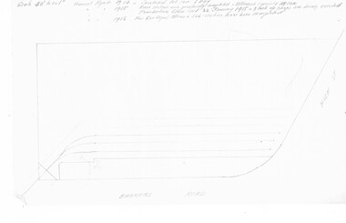
Document - Research Notes, H. S. McComb, notes on the PMTT depots, 1950's
Set of papers - 20 hand prepared foolscap sheets, giving notes on the PMTT depots, extracts from Surveyor field books, notes on doubtful matters, sketches of curves, surveyor notes, relevant dates of surveys, Items 2041 to 2052 within box 72.3 in a brown folder marked "PMTT" in red pencil.trams, tramways, pmtt, malvern, routes, track, malvern depot, kew depot, surveys -
 Orbost & District Historical Society
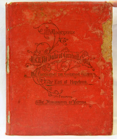
book, McCarron, Bird & Co, Addresses to H.R.H Duke of Cornwall and York, 1901
This book was published by the Municipal Association of Victoria to commemorate the inauguration of the Commonwealth of Australia in 1901. The addresses were made on the occasion of the Duke & Duchess of Cornwall & York's visit to Melbourne in May 1901. They were in the city for the opening of Federal Parliament which took place at the Exhibition Building in Carlton Gardens on 9 May 1901. .This item is associated with the history of the Federation of Australia and is a useful research tool.Hard-covered book, red cloth, with gold impressed lettering, containing 118 pages of illustrated copies of addresses to HRH Duke of Cornwall & York and His Excellency, Earl Hopetoun, the Governor General from the Shires of Victoria (includes Orbost). The addresses are surrounded by elaborate borders containing native flowers, particularly wattle. There are alsos cenes of rural Victoria. Incised on front cover - Addresses to H.R.H. Duke of Cornwall & York and his Excellency the Gov. General, the Earl of Hopetoun from the Municipalities of Victoria.federation duke-of-cornwall speeches-addresses -
 Bendigo Historical Society Inc.
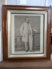
Photograph - RICHARD W LARRITT
Framed photograph of Richard William Larritt, Bendigo/Sandhurst first surveyor. Under glass in brown wooden frame with gold trim.photograph, portrait, richard william larritt -
Port Melbourne Historical & Preservation Society
Plan - Water cart used in road construction, Borough of Sandridge, 21 Nov 1870
From a group of maps and plans not required by the Port Melbourne Council Engineering Department in May 1994 and offered at that time to the Port Melbourne Historical Society.Plan of water cart used in road construction including 4 diagrams and scales: signed by Borough Surveyor, Nov 21 1870.built environment - civic, engineering, engineering department - borough of sandridge -
Whitehorse Historical Society Inc.
Document, Marie Jackschowsky claim, 1962?
Surveyor's and other notes detailing claim of Marie (Mary) Jackschowsky to land originally owned by Johann August Schwerkolt.Surveyor's and other notes detailing claim of Marie (Mary) Jackschowsky to land originally owned by Johann August Schwerkolt. Application no. 53033.Surveyor's and other notes detailing claim of Marie (Mary) Jackschowsky to land originally owned by Johann August Schwerkolt. schwerkolt, johann august, jackschowsky, mary elizabeth, schwerkolt cottage, separation street, northcote -
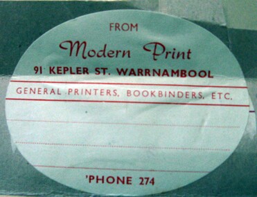 Warrnambool and District Historical Society Inc.
Label, Modern Print, Early 20th century
The Modern Print Company - engravers, lithographers, general printers , bookbinders and paper rulers- operated in Koroit Street Warrnambool. It was founded by Frederick Gaspar and Byron Laing in 1900. In 1904 the partnership was dissolved . The business continued in Koroit Street for the next 50 years. This label gives the address as Kepler Street which may have been an office outlet.This label is retained as a memento of a prominent printing business operating in Warrnambool in the early 20th century.An oval light grey label with red printing adhered to a grey piece of cardboard.FROM Modern Print 91 KEPLER STREET. WARRNAMBOOL GENERAL PRINTERS , BOOKBINDERS , ETC. PHONE 274gaspar's modern print company, warrnambool -
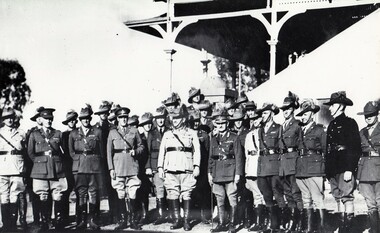 8th/13th Victorian Mounted Rifles Regimental Collection
Photograph - Lord Gowrie at Corowa Camp
The Governor General Lord Gowrie visited the 8th Light Horse regiment when it was in camp at the Corowa Showgrounds September 1939. The second World War broke out three days later. The 8th Light Horse (Indi) Regiment superseded the 16th Light Horse in 1919. It had its headquarters at Benalla with sub-units throughout the Upper Murray and Northeast Victoria. In December 1941, the regiment converted from horse to mechanised, initially as 8th Reconnaissance Battalion then in July 1942 it became 8th Cavalry Regiment and served in Northern Territory. As Japanese threat to the mainland declined the regiment was disbanded.Rare photo of gathering at outbreak of World War 2.Black and white photograph of officers at camp September 1939 at Corowa. Governor General Lord Gowrie in attendance." Governor Lord Gowrie VC. officers of 2 Cav Div and 8th Light Horse at Corowa Camp 1st Sep 1939 " followed by list of names.military, light horse, corowa, gowrie, governor general, world war two, wwii -
 Ringwood and District Historical Society
Map, Proposed Subdivision - Hilltop Estate, Heathmont, Victoria - circa 1925
Plan of Part of Crown Allotments 16 & 18, Parish of Ringwood, County of Mornington. Subdivision includes Site for Heathmont Station, Heathmont Road, George Street, Lilian Street, Edith Street, Edna Street, Great Ryrie Street. Inset locality plan also shows nearby Electric Railway Estate and Heathmont Station Estate. L.H. Webber, Licensed Surveyor, 440 Little Collins Street, Melbourne. -
Port Melbourne Historical & Preservation Society
Plan - Cutting and filling, Ingles Street from Station Place to Crockford Street, 1860 - 1874
Plan for cutting and filling re Ingles St, and cross streets Station Place to Crockford St."Borough Surveyor's Office Sandridge" upper right hand corner on face.engineering - roads streets lanes and footpaths -
Port Melbourne Historical & Preservation Society
Plan - Bridge over lagoon, Graham Street, Sandridge, Borough of Sandridge, 15 Oct 1878
Drawing of Graham Street bridge over the lagoon, 1878.Signed by E. Clark, Town Clerk, and Chas. Clay, Borough Surveyor.engineering - bridges, edward clark, town clerks, charles clay, graham street, sandridge lagoon -
Port Melbourne Historical & Preservation Society
Plan - Council Chambers, Borough of Sandridge, Borough of Sandridge, Mar 1861
1861 Plan for the Borough Council Chambers, Sandridge, showing "elevation" and "plan"."Frederick William Bull, Municipal Surveyor" (Sandridge March 28th, 1861)local government - borough of sandridge, built environment - civic, frederick william bull -
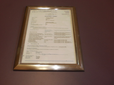 Wangaratta High School
WHS Framed Certificate, 2010
White Administration building occupancy permit, in a gold frameGRAEME BUCHAN & ASSOCIATES PTY. LTD. Building Surveyors OCCUPANCY PERMIT -
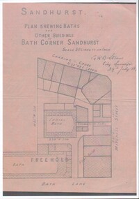 Bendigo Historical Society Inc.
Document - Plan of Buildings and Baths at Bath corner, 19/09/2023
Photographic copy of Shop layout at Bath corner Sandhurst (Charing Cross, Mitchell Street & Bath Lane); including Men's and Women's public baths dated 29 July 18??Includes singed GRB Steane, City Surveyor 29th July 18??city baths, bath corner, charing cross