Showing 2851 items
matching fences
-
 Stawell Historical Society Inc
Photograph, Family Photo in Fisher Street Stawell circa end of WW1
End of WW1 1917 -1918 - Family lived in Fisher Street. copies of 18 B/W Photos taken in yard near fence line of Path some have Peppercorn Tree. Family with pet dogs. Most men have Poppy on lapels. Geoff Bullock purchased Glass Slide Photos in garage sale in Fisher Street Stawell in early 2000's -
 Stawell Historical Society Inc
Photograph - Collection of Photos, Fisher Street: Family circa end of WW1
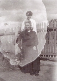
End of WW1 1917 -1918 - Family lived in Fisher Street. copies of 18 B/W Photos taken in yard near fence line of Path some have Peppercorn Tree. Family with pet dogs. Most men have Poppy on lapels. Geoff Bullock purchased Glass Slide Photos in garage sale in Fisher Street Stawell in early 2000'sTwo women outside one seated, the other standing behind. -
 Stawell Historical Society Inc
Photograph - Collection of Photos, Fisher Street: Family circa end of WW1
End of WW1 1917 -1918 - Family lived in Fisher Street. copies of 18 B/W Photos taken in yard near fence line of Path some have Peppercorn Tree. Family with pet dogs. Most men have Poppy on lapels. Geoff Bullock purchased Glass Slide Photos in garage sale in Fisher Street Stawell in early 2000's -
 Stawell Historical Society Inc
Photograph - Collection of Photos, Fisher Street: Family circa end of WW1
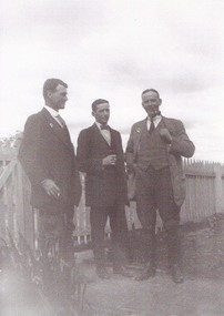
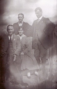
End of WW1 1917 -1918 - Family lived in Fisher Street. copies of 18 B/W Photos taken in yard near fence line of Path some have Peppercorn Tree. Family with pet dogs. Most men have Poppy on lapels. Geoff Bullock purchased Glass Slide Photos in garage sale in Fisher Street Stawell in early 2000'sFour People, three men and one lady. two men standing behind, the oher two seated. -
 Stawell Historical Society Inc
Photograph - Collection of Photos, Fisher Street: Family circa end of WW1
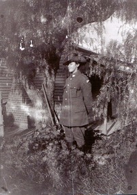
End of WW1 1917 -1918 - Family lived in Fisher Street. copies of 18 B/W Photos taken in yard near fence line of Path some have Peppercorn Tree. Family with pet dogs. Most men have Poppy on lapels. Geoff Bullock purchased Glass Slide Photos in garage sale in Fisher Street Stawell in early 2000'sA Male in Soldiers unofrom under a tree with a house in the Background. -
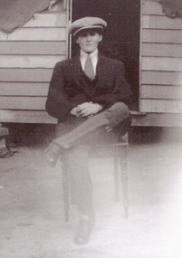 Stawell Historical Society Inc
Photograph - Collection of Photos, Fisher Street: Family circa end of WW1
End of WW1 1917 -1918 - Family lived in Fisher Street. copies of 18 B/W Photos taken in yard near fence line of Path some have Peppercorn Tree. Family with pet dogs. Most men have Poppy on lapels. Geoff Bullock purchased Glass Slide Photos in garage sale in Fisher Street Stawell in early 2000'sOne yong Man wearing a flat cap Sitting outside on a chair with wooden builing in background. -
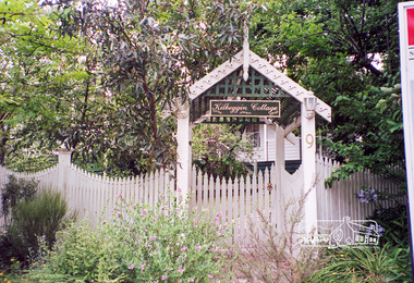 Eltham District Historical Society Inc
Photograph, Margaret Ball, 9 John Street, Eltham, 1999
"Kilbeggin Cottage" front gate, picket fence and garden obscures the weatherboard house over two blocks at 7 - 9 John Street, Eltham. Possibly a "For Sale" sign is at the side of the photograph for 11 John Street next door. Built about 1878 for carpenter Richard Bettison, John Street is part of the original Holloway subdivison in the area known as Little Eltham. The Margaret Ball (Pre 1960s Houses) Collection was a personal project initiated to mark the year 2000 and arose as a result of the disappearance of many pre-1960s parts of Eltham due to development. Approximately 200 pre-1960s style houses that were left in Eltham between Main Road and east to Bible Street, between Cecil Street to the north and south to Dalton Street were photographed in late 1999. Not all of the houses could be photographed; some because the garden or trees blocked the view of the house, others because of rubbish or cars were in the way, some because people were working on the house or in the gardens at the time.Roll of 35mm colour negative film, 7 stripsKodak GC 400-6eltham, houses, streets, margaret ball (pre 1960s houses) collection, john street -
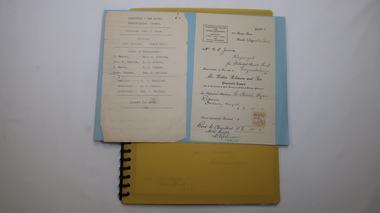 Kiewa Valley Historical Society
Folder - Kiewa Methodist Church, 1917 to 1962
The copy of a letter written by Harry H. Simmonds of Huon notes that "the church existed in 1905. It was built by Hill and McCormack with timber donated by Mr Ned Dunstan on ground donated by Mr James Thomas probably in the late 1800s. It was possibly called a Methodist Church because the donor of the land was a Methodist. It was used by the three Protestant Groups and maintenance was paid for by an annual area collection.The house on the west side was a Presbyterian Manse for many years and the block of ground on the north side was known as the Manse paddock in which the minister grazed his cow and horse." In 1936 there was a fence between the Kiewa Methodist Church was the Presbyterian Church in Kiewa. Its Certificate of Title is Volume 5134 Folio 1026783 (Sept. 1942.) In 1952, the church was made of wood with an iron roof. In 1954. Request to Yackandandah Shire re a fence from Kiewa Consolidated School entrance to the unused hedge adjacent to the Church. In 1958 there was correspondence re 'the strip of land on each side of the Church.' Churches were an important part of life during the late 19th century and early to mid 20th century and were built in the centre of town as was this one. These papers give an understanding of the work involved in maintaining a church. The letters and 'book' give a lot of names of local families involved with the Methodist Church at Kiewa. Yellow plastic spiral folder with 18 pages enclosed in clear plastic sleeves.Papers enclosed include accounts, payments, tenders and other correspondence relating to the Methodist Church at Kiewa dating from 1932 to 1962. Of particular interest is a black cardboard cover book dated 1917 re collection of donations from listed people. The latest date in the book is 1942.Enclosed in first plastic sleeve is a letter from the donor, Kathie Vines dated 15th July 2013methodist church; kiewa; harry h. simmonds; yackandandah council; -
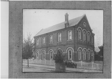 Ballarat Clarendon College
Photograph
In August 1874 the College Trustees agreed to a loan by Mr Leckie of £1500 at 8% over three years, and the foundation stone of a new building, on the corner of Lyons and Sturt Streets in the grounds of St Andrews Kirk, was laid on 12 September by Rev Henderson, founder of the College. Designed by leading Ballarat architect Henry Caselli and built by contractors Taylor and Ellis, the building was opened for January 1875 classes. In February 1875 the original church hall was sold cheaply and moved from the site. The girls' section of the college was moved to the schoolrooms connected with the Baptist Church in Errard Street Sth. The girls school operated 1877 - 1892. Ballarat College moved to current senior campus premises at 1412 Sturt Street in 1912. A plaque commemorating the Caselli building remains on the original site. The photograph features southwest faces of building, surrounded by a picket fence; seven young boys are standing in front of the fence along the Lyons Street side. Grayscale photograph with hessian and card mountBottom right corner of photograph: ....tuhards....caselli, ballarat college, buildings -
 Orbost & District Historical Society
black and white photograph, 1920s -1930s
The Cabbage Tree Creek township was originally established to support the booming timber industry of the mid 20th century. Five timber mills worked full time supporting the families that were drawn to the area's wealth of natural resources. The settlement of Cabbage Tree Creek is located on the Princes Highway, 27 km east of Orbost in East Gippsland. The first white settler arrived in the valley in 1887 cutting a dray track from Marlo to the south-west. Several families cleared the alluvial flats, growing maize, peas and beans and raising pigs, cattle and sheep. Later the farmers milked cows, sending cream to Orbost. In the late 1890s, small quantities of alluvial gold were found in the creek. A school commenced classes in 1913, but enrolment was small and at times the school operated part time with several other small schools in the area. The school building served as a hall for the district. From the 1920s the Cabbage Tree Hotel catered to drivers on the improved Princes Highway. (info. from Victorian Places)This is a pictorial record of Cabbage Tree, East Gippsland in the late 20th century. It shows a building that no longer exists.A small black / white photograph of a single storey timber building. On a sign below the roof is "Cabbage Tree Hotel". The hotel is surrounded by a wooden picket fence. A man and woman are standing on either side of a motor car parked on the roadway in front of the building.on back - on label - Cabbage Tree Hotelcabbage-tree-hotel -
 Glenelg Shire Council Cultural Collection
Postcard - Postcard - Casterton, Victoria, c. 1946
SOURCED FROM CASTERTON TOWN HALL (FORMER SHIRE OF GLENELG)Black and white photo postcard. Casterton 1946 flood. Man in overalls in foreground behind barbed wire fence, several 44 gallon drums. Buildings on left, tractor towing horse float, whole area flooded, no dry land visible.Back: Purple stamp 'POSTCARD' Purple photographer's stampcasterton, flood, 1946, tourism -
Glenelg Shire Council Cultural Collection
Photograph - Photograph - Henty Beach, Portland, 1950s
Black and white photo of small children in bathers on Henty Beach, Portland. Children standing on wooden stage in front of ramp. Bunting on ramp fence and hanging from stage. Brass band in foreground. Possibly Goldraiders bathing competition, summer 1950s.Back: 350-32 - pencilportland photography, bathing competition, henty beach -
Glenelg Shire Council Cultural Collection
Print - Contact Print, 1960-1979
Sheet of 2 contact prints from glass plate negatives. Top: Weatherboard house with return verandah, picket fence. 3 people in garden. Bottom: Seascape, Blacknose Point, Cape Grant. Woman with horse and buggy on cliff top, foreground. -
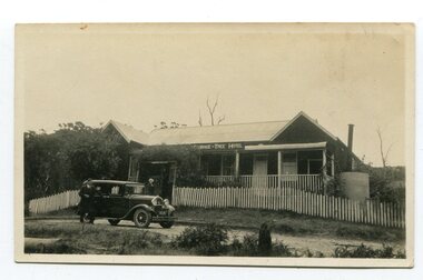
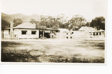 Halls Gap & Grampians Historical Society
Photograph - Sepia, C 1921
Stores in Halls Gap.The photo shows a shop (with Thomson's Cakes" on a sign on the roof) with four bicycles at the front. There is a man standing behind the bikes. To the right of the shop is a fence, with an Atlantic Petrol sign attached to it and two petrol pumps in front of it. Further to the right is another store/cafe.buildings, shops -
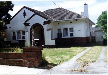
 Glen Eira Historical Society
Photograph, Murrumbeena Road, 220, Murrumbeena, 2001
Originally labelled "Beauville Estate, Established 1936, Still Thriving 65 years on, 10th March 2001", the Beauville Estate Album contains colour photographs of houses in the Estate. They were taken around the time of the Beauville Estate’s 65th Heritage Celebration held on 10/03/2001 and donated to the Caulfield Historical Society shortly afterwards. Photographer unknown. No. 220 is NOT covered by the Heritage Overlay HO12 but the property has a number of similar features to those in the Estate.Colour photograph of a white rendered brick house with leadlight windows. Other features include a columned porch, striped awnings, black frames around the windows, chimneys, tiled roof and a high unpainted variegated brown brick fence beside the driveway.murrumbeena, houses, 1930's, inter war style, a.v. jennings, av jennings, jennings, brick houses, beauville estate, porches, lead lights, stained glass, murrumbeena road, architectural features, jennings group limited, land subdivision, brick features, brick walls, chimneys, striped awnings -
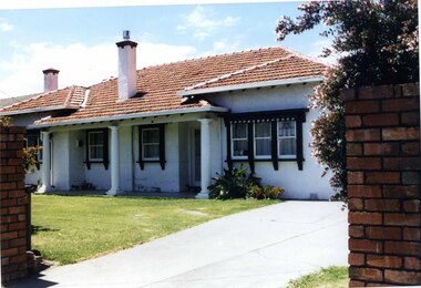
 Glen Eira Historical Society
Photograph, Dalny Road, 9, Murrumbeena, 2001
Originally labelled "Beauville Estate, Established 1936, Still Thriving 65 years on, 10th March 2001", the Beauville Estate Album contains colour photographs of houses in the Estate. They were taken around the time of the Beauville Estate’s 65th Heritage Celebration held on 10/03/2001 and donated to the Caulfield Historical Society shortly afterwards. Photographer unknown. City of Glen Eira’s Heritage Management Plan Vol 2 p79 (this is p84 of the pdf version) – HO12 Beauville Estate and environs, Murrumbeena: The Beauville Historic Area is important at the State level as the first large housing estate undertaken by the AV Jennings Construction Co, later Jennings Group Limited, Victoria’s largest home builder. It is important also as a very early estate development incorporating a range of features other than houses and including made roads, shops and recreation facilities. In this respect it was the forerunner of the comprehensively planned housing estate of the post war era. The estate is distinguished by its aesthetic values, as is the earlier and comparable Hillcrest Estate, which are formed by a combination of restrained diversity in house styles, with the exception of no. 30 in the emerging International style, and by a landscaped garden environment. Colour photograph of a rendered brick house with unpainted decorative variegated brown brick features. Other features include tiled roof, chimneys, sash windows, concrete driveway, garage, porch with an arched entrance and a low unpainted brick fence in the foreground. murrumbeena, houses, architectural styles, 1930's, inter war style, a.v. jennings, av jennings, jennings, brick houses, beauville estate, dalny road, porches, sir albert victor jennings, a v jennings construction co, beauville estate heritage area, glen eira city council, architectural features, jennings group limited, land subdivision, beauville historic area, brick features, chimneys, garage (private), arches, sash windows, rendered houses -
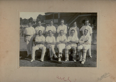 Bendigo Historical Society Inc.
Photograph - ?B.U.C CLUB, CRICKET TEAM
B+W photo of cricket team. 11 men in cricket gear, 3 at front wearing pads. In background are part of grandstand, fences, trees, and part of building with sign reading : '?B.U.C Club Harold Williams left end back row?'Bartlett Bros. Bendigoorganization, club/society, ?b.u.c.club, cricket club, james lerk ' cricket team b.u.c.c upper reserve, bendigo', helen mamka 9.11.2001 'this photo is not in ken wust's book: bendigo district cricket 1953-1990 -
 Bendigo Historical Society Inc.
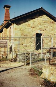
Photograph - I WILLIAMS COLLECTION: POLICE BARRACKS
Collection of photographs -Mr I Williams , 9 Monreith Ave 21.3.84 - photograph of Police Barracks, located in Rosalind Park, showing renovation work. Wire fence surrounding stone building. MR I WILLIAMS , 9 MONREITH AVE 21.3.84photograph, building, collection of photographs -mr i williams , 9 monreith ave 21.3.84 -photograph of police barracks -
 Bendigo Historical Society Inc.
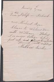
Document - ANCIENT ORDER OF FORESTERS NO. 3770 COLLECTION: CORRESPONDENCE
Note written on cream paper and dated January 11th, 1872. Dear Istop in Ironbark. Neer Michael Ryan. Cloase to Watsons Dam with William Foley it is anew Cotage lately put up and cloase to garden fenced with saplings. Matthew Burke.societies, aof, correspondence, ancient order of foresters no. 3770 collection - correspondence, islop, michael ryan, watsons dam, william foley, matthew burke -
 Bendigo Historical Society Inc.
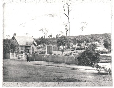
Photograph - WES HARRY COLLECTION: BENDIGO CEMETERY, 1860's
Photograph of the Bendigo Cemetery showing some headstones among the trees. Caretakers cottage ?, Chapel ?, on the left of the shot with some children and an older man in front. There is a picket fence along the front of the cemetery and a cow standing on the roadway at the right hand edge of the photo.Batchelderplace, cemetery, bendigo cemetery, carpenter street, bendigo cemetery, batchelder -
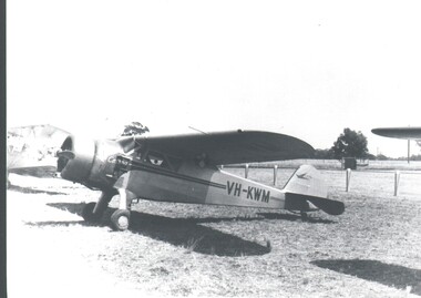 Bendigo Historical Society Inc.
Photograph - HARRY BIGGS COLLECTION:CESSNA AEROPLANE
Photograph of an early model Cessna Aeroplane at a rural airport, there are portions if two other planes visible beside it. A fence is in the background and a sign behind that which is Partially obscured, '--men', a man is standing in front of the sign. The registration letters on the plane are VH - KWMplace, transport, aeroplane, cessna , vh- kwm -
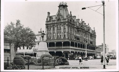 Bendigo Historical Society Inc.
Photograph - BENDIGO - SHAMROCK HOTEL
Photograph - black and white. Photo of Shamrock Hotel, Bendigo, war statue in centre. (number written on left hand side No.24). Soldier memorial left of centre. Iron fence surrounds lawn and shrubbery, old toilet block extreme left.buildings, hotel, shamrock hotel., shamrock hotel, bendigo. -
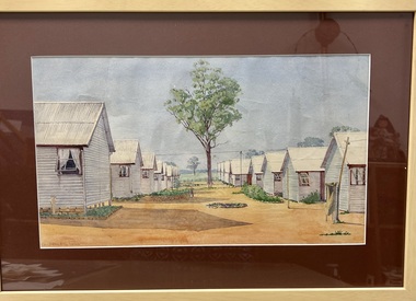 Tatura Irrigation & Wartime Camps Museum
Painting - Painting - Water Colour
Glunkler was interned in Camp 3Water colour of two rows of huts. Each row has eight huts with the windows open. There is a single gum tree in the centre between the two rows and some tree in the background beyond a fence. Small gardens with stone edging are around the huts.Glunkler 1943 -
Tatura Irrigation & Wartime Camps Museum
Photograph, 22 September 1991
Photographed at the German War CemeteryColour photograph of a large group attending a service at German section of Tatura Cemetery. 22 September 1991. Deiter Ruff (Templer Society) speaker. Two large gum trees dominate the photo with a couple of boxes in front of the chain wire fence.tatura war cemetery, deiter ruff, templer society -
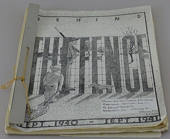 Tatura Irrigation & Wartime Camps Museum
Book, Behind the Fence, 1941
Made by internees, Singapore Group Refugees at Camp 3 Tatura for entertainment purposesSoft cover loose leaf book "Behind the Fence" Sept 1940 - Sept1941. 12month periodical. Has camp sketch on front cover. Written (typed) in English and German. Black & White illustrations and sketches. Card cover bound with coloured thread.tatura, singapore group camp 3, books, history, local -
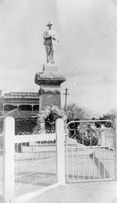 Stawell Historical Society Inc
Photograph, Soldiers’ Memorial World War 1 in Main Street in front of the Stawell Guest House
Soldiers’ Memorial WW1 with the Stawell Guest House (Coffee Palace formerly Castlemaine Hotel) and roof of weighbridge in the background. The photo is a copy of the original owned by Mrs. Gwen Reeve. Black and white photograph of the WW1 Soldiers Memorial with a large floral wreath at the base. The photo shows the gate and fence Infront of the memorial. The Stawell Guest House also called the Coffee Palace and roof of the Weighbridge can be seen in the background. c.1935stawell ww1 -
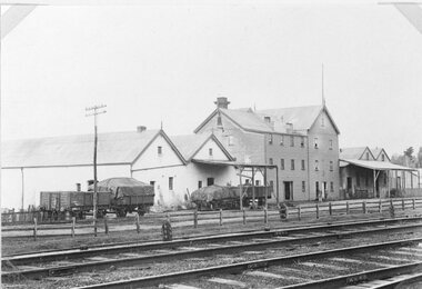 Stawell Historical Society Inc
Photograph, Wimmera Flour Mill with adjoining Buildings c1920s -- 2 Photos --1 Coloured
2 photos of three story flour mill and adjoining buildings 1920's.Two photographs of railway tracks in front of the Stawell flour mill and adjoin buildings. Two people are standing in front of the three story flour mill with a timber fence along the railway tracks and a telephone pole in front of two of the four rail wagons. stawell industry -
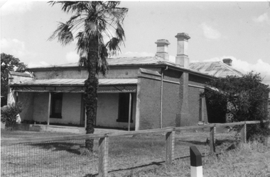 Stawell Historical Society Inc
Photograph, Brick Home at 9 Seaby Street -- 2 Photos
Brick Home 9 Seaby Street originally built by Crothers Family. Now owned by Mr. and Mrs. Peter Carey, The house is located on the corner of Luke and Seaby St. This house was imported from Canada. All components are numbered. It has a cavity wall construction. The present owners have carefully restored this house.Two black and white photograph of a large brick home. Roof is corrugated iron with a veranda across the front. A large palm tree in front. Fence along the side is wire mesh with timber supports. The second photo is a closer side view of the house. stawell -
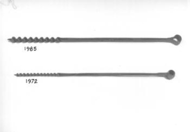 Whitehorse Historical Society Inc.
Tool - Auger Bit
Long steel shaft half of which is twisted into a corkscrew shape and sharpened to make a hole in wood. The other end has been formed into a round hole so that a handle may be inserted to turn the drill. Used for drilling hole in fence post.rural industry, fencing -
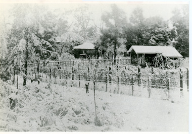 Mt Dandenong & District Historical Society Inc.
Photograph, Erith Lane
Erith Lane would have been named after Eliza Erith, the wife of Thomas Hand of Mountain Grange. The house made of slabs and bark pictured (centre) is where the family lived before Mountain Grange was built. Mabel Hand, Thomas and Eliza's youngest daughter stated that she was born in the bark hut in 1881 and they moved into the new home the same year. Cherry Farm, the roof visible behind the centre building, was the home of William Hand, son of Thomas and Eliza. He lived here with hs wife, Harriet Toghill, before moving to live at Mountain Grange after 1905.Black and white photograph showing a scene under heavy snow. Two cottages and a rooftop visible. Snow laden vines forming the front fence. Taller trees visible in the background. Reverse of photograph has handwritten description by John Lundy-Clarke.Erith Lane under snow. House in passion fruit Ivory’s holiday home 1921. Building in centre was Hand’s 28’ by 22’ house of slabs and bark. The first house on top of the whole Dandenong Range built 1871. Large roof behind it was “Cherry Farm”.eliza erith, eliza hand, mabel hand, thomas hand, william hand, erith lane, kalorama, snow, mountain grange, cherry farm, harriet toghill