Showing 3925 items
matching forest
-
 Whitehorse Historical Society Inc.
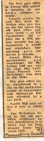
Newspaper - Article, Post Office, 1983
Article in Nunawading Gazette about the first Post Office in Forest Hill. The first postmistress was Catherine Peacock (and storekeeper) who died in the 1930's. Later the P.O. was transferred to the North West corner of Canterbury Road and Springvale Road. The first Post Office and store was located at 259 Canterbury Road and this building was demolished in 1950.post offices, peacock, catherine, mcarthur, archibald, canterbury road, forest hill, no 259, forest hill post office -
 Whitehorse Historical Society Inc.
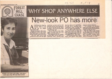
Newspaper - Article, New look post office has more, 2/02/1993
Article in Nunawading Gazette. Australia Post has moved its office from 49 Mahoneys Road to Forest Hill Chase Shopping Centre. It will be a new style post office selling cards and Australiana items etc. New system is called EPOS, the cash register has postal prices set in its memory.post offices, forest hill post office, australia post, forest hill chase -
 Southern Sherbrooke Historical Society Inc.
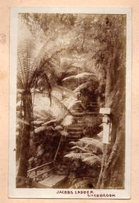
Photograph, Jacobs Ladder, Sherbrooke
Photo of Jacob's Ladder in Sherbrooke Forest. Looks to be water under the bridge at the bottom of the photo. Very steep wooden steps going up through ferns. There is a wooden seat halfway up the visible steps, to the right of the steps. There are three signs attached to a tree on the right side of the photo near the creek. The sun is shining on the ferns. -
 Ballarat Tramway Museum
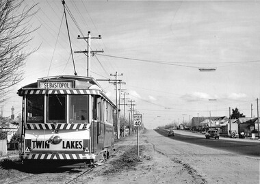
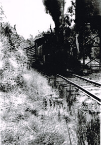
Photograph - Black & White Photograph/s, Charles Craig, Aug. 1971
Yields information about tram operations in Albert St Sebastopol and the Grey St crossing loop.Black and white photograph of No. 12 about to enter the Grey St loop, Albert St. Alongside the tram is a 40mph speed limit sign, Albert St shops and a Forest City signal. Photo by Charles Camera, at the time of the first closure of the Ballarat system, 23/8/1971 when the Victoria St line closed.trams, tramways, albert st, grey st loop, sebastopol, tram 12 -
 Phillip Island and District Historical Society Inc.
Photographs, 1926
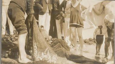
Part of a collection of photographs from an old photo album with multiple photos per page. Donated by Margaret Webster. Her parents were Sir Charles & Lady McGrath who lived on Ventnor Road, Cowes near the RSL286-12 - Sepia photograph of a group of people with a net of fish at Cowes, Phillip Island. 286-13 - Sepia photograph of two women on the beach at Newhaven, Phillip Island. 286-14 - Sepia photograph of three people and a car at Newhaven, Phillip Island. 286-15 - Sepia photograph of a woman holding a Mutton Bird. 286-16 - Sepia photograph of Forrest Caves, Phillip Island. 286-17 - Sepia photograph of three people on rocks at Forrest Caves, Phillip Island.286-12 - "A haul of trout, Cowes." 286-13 - "Newhaven, Phillip Island" 286-14 - "A rest a Newhaven P.I." 286-15 - "A Mutton Bird P.I." 286-16 - "The Caves P.I." 286-17 - "Forest Caves P.I." (Should be "Forrest" with two "r's")forrest caves phillip island, fishing catch, newhaven, mutton bird, native wildlife, margaret webster -
 Ringwood and District Historical Society
Newspaper, Scrapbook Clipping, Library Collection, Ringwood, Victoria
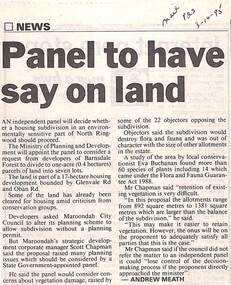
Newspaper Clipping from "The Mail", 3-10-95. P23. By Andrew Meath. Panel to have Say on LandAn independent panel will decide whether a housing subdivision in an environmentally sensitive part of North Ringwood should proceed. The Ministry of Planning and Development will appoint the panel to consider a request from developers of Barnsdale Forest to divide one acre (0.4 hectares) parcels of land into 7 lots -
 Orbost & District Historical Society
black and white photograph, first half 20th century
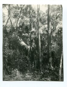
Livistona australis - the Cabbage Tree Palm, is a fan palm that grows naturally in the lowland forest and swamps of southern Queensland and along the east coast of Australia and it occurs further south than any other Australian palm species. It is the only palm that is found naturally in Victoria. The early settlers supplemented their meagre rations with the hearts of the Cabbage Tree Palm.This is the southernmost stand of Cabbage Tree Palms in Australia and the only location in Victoria where these palms grow naturally. This is a pictorial record of a rare native Australian palm.A black / white photograph of small palm trees in a dense bush surrounding.cabbage-tree-palm-east-gippsland -
 Otway Districts Historical Society
Book, B. & B. Strange, Ballarat: the formative years, April 1982
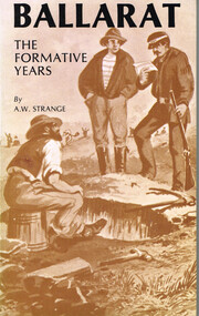
From 1838 early Ballarat was settled by pastoralists in ideal conditions, a peaceful, verdant valley where the hills were clothed in virgin forest and the flats covered with lush pasture. Then gold was discovered to spark off what was Victoria's first great gold rush. This book covers the gold rush after on the aboriginal ownership and early pastoral activities.Ballarat: the formative years. A.W. Strange. B. & B. Strange; Ballarat (Vic); April 1982. viii, 100 p.; illus.; map. Soft cover. ISBN 0 9596802 3 3Signed: "A.W. Strange 10/1/1983" Map inside back cover.ballarat; pastoralism; aborigines; gold rush; mining; eureka; local government; a.w. strange; -
 Otway Districts Historical Society
Photograph, Les Ogden, Crowes track being dismantled at ashpit, 1961, 1961
On the Colac-Beech Forest-Crowes railway line the section from Ferguson to Crowes was closed in December 1954, but reopened as far as Weeaproinah in January 1955. The section to Crowes, left to its own devices, was rapidly covered with vegetation which had to be cleared when rail recovery trains later ran. The track to Crowes was pulled up in 1961. Crowes track being dismantled at the ashpit ready for loading into NQR wagons. colac; beech forest; crowes: railway; -
 Otway Districts Historical Society
Photograph, Les Ogden, Wimba: Loco 14A takes water, c.1961, c.1961
Opened with the line as Bunding its name was changed to Wimba in November 1902 and remained as this until the line closed. The line was briefly flatish at this point until climbing more than 1000 feet to Beech Forest, so a water tank was placed on the side of a hill about 100 metres south of the station. Loco 14A takes water at this tank.B/W. Locomotive 14A, NU louvred van, and others, take water at Wimba in c.1961. Water tank top right.wimba; railway; loco 14a; -
 Bendigo Historical Society Inc.
Document - RESEARCH PAPERS: DR KEITH COLE HISTORY OF ALL SAINTS CHURCH BENDIGO, 1990
The Anglican church established a tent church on Agitation Hill in 1852. In January 1855 the foundation stone for All Saints was laid on the corner of Forest and MacKenzie Streets. The church opened for worship in June 1856. It was initially named the Anglican Cathedral (seat of the Bishop). Cathedral status was lost to St Pauls in 1980 when Bendigo became a separate diocese.An outline of a lecture dedicated to the history of the Bendigo All Saints' Church that began in 1852 and shut its doors in 1989dr keith cole, all saints church -
 Melbourne Tram Museum
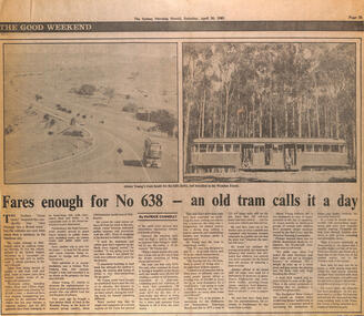
Newspaper, "Fares enough for No. 638 - an old tram calls it a day", 30-4-1983
Newspaper clipping from the Sydney Morning Herald, about the sale and transport of W2 638 to Wombat Forest. Item written by Patrick Connelly, Has two photographs, one being transportedand the other located on its new home. Article looks at the story behind the purchase ($250), plus transport costs. Purchased by Alistair YoungYields information about the disposal of a W2 class tram.Newspaper clipping from The Sydney Morning Herald, 30-4-1983 about the sale of Melbourne W2 638. trams, tramways, sale of trams, w2 class, w2 638, transporting trams -
 Orbost & District Historical Society
booklet, A Brief History of the Brass Bands of Orbost Australia 1889-1975, 8.11.1975
This booklet was compiled for the anniversary celebrations of the Orbost Municipal Band on November 8, 1975. It was compiled by Peter Fagg who worked as a scientist with the Department of Sustainability and Environment (now DELWP) to study dieback in eucalypts. He specialised in the silviculture of the eucalypt forest types of South-East Australia for most of his 40-year career, which started with the Forests Commission Victoria. He was in Orbost from 1968 - 1973. The first Orbost Brass Band was formed in 1889. Around 1908 the town band split and the Orbost Workers' Band was formed. Eventually the two bands merged in 1913 to reform as the Orbost Municipal Band under conductorship of Charles Spink. The band continued for many years but was later disbanded and again reformed. This was to happen a number of times, the last time being in 1961 and continuing through to the late 1970's. Further info and Ref: In Times Gone By - Deborah HallThe various Orbost bands over the years played a major role in community activities providing entertainment and musical experiences for the many members.A 12 pp stapled booklet compiled for the anniversary celebration of the Orbost Municipal Band. It has been typed in black ink on foolscap sized white paper.orbost-municipal-band music-orbost fagg-peter -
 Orbost & District Historical Society
framed coloured photograph, December 1978
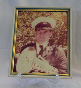
Mr E. Knight was the president of the Orbost Municipal Band from 1972 - 1978. The photographer, Peter Fagg, worked as a scientist with the Department of Sustainability and Environment (now DELWP) to study dieback in eucalypts. He specialised in the silviculture of the eucalypt forest types of South-East Australia for most of his 40-year career, which started with the Forests Commission Victoria. He was in Orbost from 1968 - 1973. The first Orbost Brass Band was formed in 1889. Around 1908 the town band split and the Orbost Workers' Band was formed. Eventually the two bands merged in 1913 to reform as the Orbost Municipal Band under conductorship of Charles Spink. The band continued for many years but was later disbanded and again reformed. This was to happen a number of times, the last time being in 1961 and continuing through to the late 1970's. Further info and Ref: In Times Gone By - Deborah Hall The various Orbost bands over the years played a major role in community activities providing entertainment and musical experiences for the many members.A coloured photograph of a man in a band uniform holding a brass instrument ( a french horn?). It is under glass framed in a white and gold wooden frame.on back - ".....E. Knight.......Dec 1978"music recreation orbost-municipal-band knight-g. -
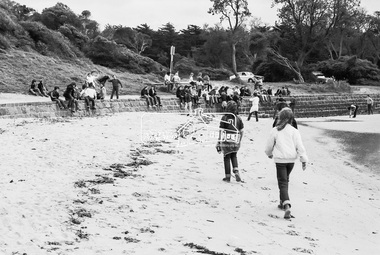
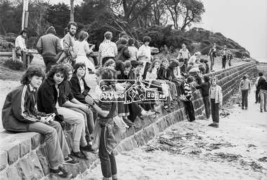
 Eltham District Historical Society Inc
Photograph, George Coop, Sunnyside Beach, Mount Eliza, c.August 1983, 1983
Possibly an excursion or school camp for Year 8 or 9 students from Nunawading High School to the seaside at Mount Eliza. Nunawading High School opened on Canterbury Road (near Mahoneys Road) in 1955. Enrolments grew rapidly and by 1969 there were over 1,100 students, making it one of the largest schools in the state. In 1989 it was merged with Burwood Heights High and Blackburn South High to become a junior campus of Forest Hills Secondary College. However, the junior campuses were closed in 1997, and the former Nunawading High was bulldozed to make way for a housing estate. "Lost Schools of the 1990s", Learning from the Past, http://learningfromthepast.com.au/lost-schools-of-the-1990s/ George Coop was a teacher of art, craft, wood working and graphics at Nunawading High School until it merged into Forest Hills Secondary College at which point he retired.Digital TIFF file Scan of 35mm Kodak Safety 5062 black and white transparencymount eliza, nunawading high school, sunnyside beach -
 Eltham District Historical Society Inc
Photograph, George Coop, Sunnyside Beach, Mount Eliza, c.August 1983, 1983
Possibly an excursion or school camp for Year 8 or 9 students from Nunawading High School to the seaside at Mount Eliza Nunawading High School opened on Canterbury Road (near Mahoneys Road) in 1955. Enrolments grew rapidly and by 1969 there were over 1,100 students, making it one of the largest schools in the state. In 1989 it was merged with Burwood Heights High and Blackburn South High to become a junior campus of Forest Hills Secondary College. However, the junior campuses were closed in 1997, and the former Nunawading High was bulldozed to make way for a housing estate. "Lost Schools of the 1990s", Learning from the Past, http://learningfromthepast.com.au/lost-schools-of-the-1990s/ George Coop was a teacher of art, craft, wood working and graphics at Nunawading High School until it merged into Forest Hills Secondary College at which point he retired.Digital TIFF file Scan of 35mm Kodak Safety 5062 black and white transparencymount eliza, nunawading high school, sunnyside beach -
 Eltham District Historical Society Inc
Photograph, George Coop, Sunnyside Beach, Mount Eliza, c.August 1983, 1983
Possibly an excursion or school camp for Year 8 or 9 students from Nunawading High School to the seaside at Mount Eliza Nunawading High School opened on Canterbury Road (near Mahoneys Road) in 1955. Enrolments grew rapidly and by 1969 there were over 1,100 students, making it one of the largest schools in the state. In 1989 it was merged with Burwood Heights High and Blackburn South High to become a junior campus of Forest Hills Secondary College. However, the junior campuses were closed in 1997, and the former Nunawading High was bulldozed to make way for a housing estate. "Lost Schools of the 1990s", Learning from the Past, http://learningfromthepast.com.au/lost-schools-of-the-1990s/ George Coop was a teacher of art, craft, wood working and graphics at Nunawading High School until it merged into Forest Hills Secondary College at which point he retired.Digital TIFF file Scan of 35mm Kodak Safety 5062 black and white transparencymount eliza, nunawading high school -
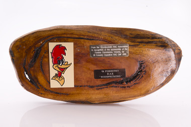 Forests Commission Retired Personnel Association (FCRPA)
Presentation plaque from the "Woodpeckers"
In the post-war era from 1947 to the mid-1980s, the Forests Commission sponsored Australia's only military sawmilling unit, the 91 Forestry Squadron. It was a special reserve unit of the Royal Australian Engineers (RAE). Established and commanded by Commission forester and WW2 veteran, Major Ben Benallack, the "Woodpeckers" as they were known comprised a small pool of specialised soldiers capable of rapid mobilisation in the event of need. Several other Victorian departments such as the State Electricity Commission (SEC) did the same thing who supported a construction squadron based at Newborough in the Latrobe Valley. The scheme created a very active and capable part-time military group that completed many worthy projects across the State. In addition to their military training, the Woodpeckers operated bush sawmills, built timber bridges along the Murray River, the Snake Island Jetty, forest roads and performed various demolition tasks.Presentation plaque from the "Woodpeckers" Mounted on polished wooden burl -
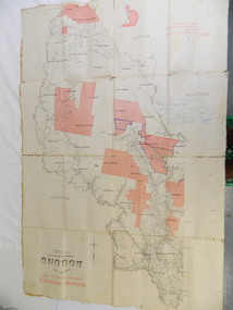 Kiewa Valley Historical Society
Map - Kiewa Valley, County Map of Bogong, 27/11/1905
This map has been owned by the Ryder Family of the Kiewa Valley for possibly over 100 years (1905?). It was used when the family mustered and maintained cattle on their grazing lease on the Bogong High Plains. Obviously a field map used on these occasions.This map was used by the Ryder Family who lived in the Kiewa Valley and who grazed cattle on their lease on the Bogong High Plains during summer.Showing reserves Under the Forest Act of 1907. This is a paper map which has been mounted or glued on pink and cream floral cotton. It is obvious by its poor condition that it has been used outdoors in the field. It is not in very good condition as it has been folded 4 times (8 divisions) and it is badly worn and cracked in the creases.Photo Lithographed at the Department of Lands and Surveys by T.E.McGauran 27/11/05 Price 1/3d. Scale - 2 miles to an inch. F.S. Hilcke Oct. 2nd 1905.department of lands and surveys map; ryder family; bogong high plains -
 Glenelg Shire Council Cultural Collection
Certificate - Share Certificate - Pine Plantations, c. 1950
Share certificate: Pine Plantations Pty. Ltd. Plantation Portland No. 7. Issued to John Seymour Dening of Matcham via Gosford NSW. One acre portion, £100. No. 471. Butt coloured paper, orange patterned border, orange illustration of forest and figure with torch & shield bearing Australian coat of arms, in centre of share certificate. -
Federation University Historical Collection
Map, Otways Walks and Waterfalls Map, 2013, 06/2013
Tourist map of the Otways showing the townships of Colac, Lorne, Apollo Bay, Beech Forest, Forrest, Barwon Downs, Deans March, Winchelsea, Gellibrand, Lavers Hill, POrt Campbel, Princetown, Johanna, Timboon, Cobden, Camperdown, Swan Marsh, Simpson, Birregurra, Beeac, Marengo, Wye River, Kennett River, Skenes Creek, Peterboroughcolac, lorne, apollo bay, beech forest, forrest, barwon downs, deans march, winchelsea, gellibrand, lavers hill, port campbel, princetown, johanna, timboon, cobden, camperdown, swan marsh, simpson, birregurra, beeac, marengo, wye river, kennett river, skenes creek, peterborough< marriners falls, beauchamp falls, hopetoun falls, triplet falls, little aire falls, stevensons falls -
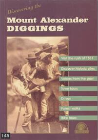 Bendigo Historical Society Inc.
Book - BOOK: DISCOVERING THE MOUNT ALEXANDER DIGGINGS - MOUNT ALEXANDER DIGGINGS COMMITTEE, 1999
Softcover book with purple cover and a detail from a sepia photograph of miners in Forest Creek in 1858. The book is a guide to the Mount Alexander goldfields with historical notes, sites to visit, suggested tours, drives and walks. The areas covered include Chewton, Castlemaine, Campbells Creek, Vaughan, Fryerstown Newstead and Maldon. Indigenous stories are also included.Mount Alexander Diggins Committeegoldfields, gold mining, mount alexander, castlemaine, campbells creek, maldon, indigenous stories -
 Bendigo Historical Society Inc.
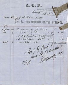
Document - ANCIENT ORDER OF FORESTERS NO. 3770 COLLECTION: ACCOUNT
Account printed on blue paper dated December. 10 1863. A. O. F. Court King of the Forest No 3770. Dr. to The Bendigo United District. Account is for Sept. 20, Oct 19 and Nov. 11 for Goods, Copies of Laws, Member's Certificates and Emblems. Rec. by Cash Signed by J. Madeley and dated 28/12/63.societies, aof, correspondence, ancient order of foresters no. 3770 collection - account, aof, the bendigo united district, j madeley -
 Bendigo Historical Society Inc.
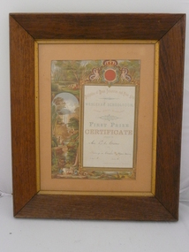
Document - PHOTO - ADDRESS - WESLEYAN SCHOOLROOM, 1880
Exhibition of Home Industries and fine arts. Wesleyan schoolroom. Forest street. Sandhurst. 1880. First Prize Certificate awarded to Miss. E. A Craven for drawing in crayon. Figure division. In Class A. Section 3. James Thomas. Hon Secretary. Coloured drawings of the bush, people, waterfall, trees and kangaroos. Markings: Evening news office. Sandhurst.person, individual, certificate -
 Bendigo Historical Society Inc.
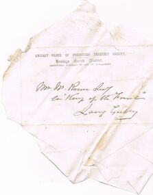
Document - ANCIENT ORDER OF FORESTERS NO. 3770 COLLECTION: CORRESPONDENCE
Envelope addressed to Mr. W. Rowe Sec ? King of the Forest, Long Gully. Printed Ancient Order of Foresters' Friendly Society. Bendigo United District, Registed Pursuant to Act of Parliament, at the top. Envelope has been opened out and some names written on the back - S C R Salter, S Rosie, Daniels.societies, aof, correspondence, ancient order of foresters no. 3770 collection - correspondence, w rowe, king of the forest, s c r salter, s rosie, daniels