Showing 3899 items matching "bricks"
-
 Orbost & District Historical Society
black / white photograph, first half 20th century
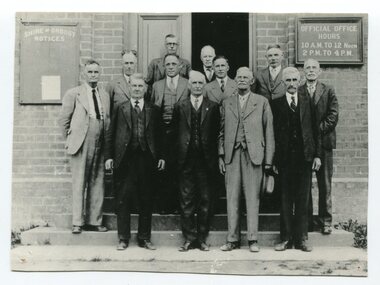
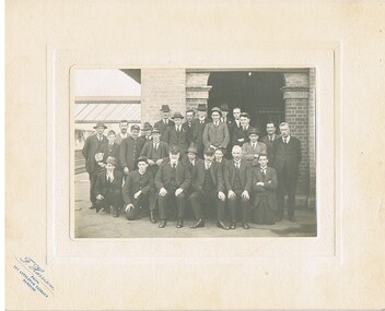
This is a photograph of some of the Orbost Shire councillors standing outside their council chambers. This photograph was taken before 1969 outside the previous council offices in Orbost. The current building was opened on Friday 28th February 1969 by the Premier of Victoria, The Hon. Sir Henry E. Bolte, K.C.M.G., M.P. The Shire of Orbost was a local government area about 380 kilometres east of Melbourne, the state capital of Victoria, Australia. The shire covered an area of 9,347 square kilometres and existed from 1892 until 1994. Originally, Orbost was part of the Bairnsdale Road District which was created on 30 April 1867. Splitting away as part of the Shire of Tambo in 1882, Orbost was first incorporated as a shire in its own right as the Shire of Croajingolong on 30 May 1892. It received its present name on 17 February 1893. On 3 January 1913 part of its western riding was annexed to Tambo as its Cunninghame Riding. Local governments play an important role in the lives of citizens in Australia. Local government authorities exist to provide services and amenities to local communities, and are also responsible for regulating and providing services for land and property in their district. This item is representative of a time when Orbost had its own Shire Council. A black / white photograph of a group of men standing in front of an open door of a brick building. On the left of the building is a Shire of Orbost notice board and on the right wall is a notice of the office opening hours - 10AM - 12 NOON 2PM - 4PMorbost-shire-council local government -
 Bendigo Military Museum
Photograph - BENDIGO SANDAKAN SERVICE, 7.3.1999 and 12.3.2000
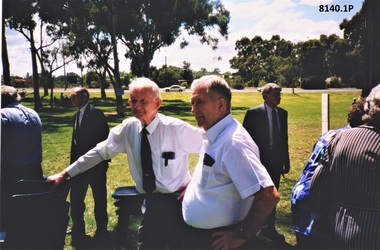
Both photos were taken at Strathdale Park in Bendigo, one on 7.3.1999 & 12.3.2000 at the Annual Sandakan Commemoration Service. The first year it was held was in 1999, a memorial with names had been erected in the park. .1) The men in white shirts are Norm Smart and Jack Barnes. Refer Cat No's 8131.2P, 8040. .2) The two men are Jack Barnes and Jim Disken (James Cecil VX151742)Two colour photographs relating to the Bendigo RSL Sandakan commemoration. .1) Shows two men in white shirts with several others in the background park setting. .2) Shows two men standing in the park with a brick building in the background..1) On rear in blue pen, "Sandakan Commemoration Sund 7.3.1999". .2) On rear in blue pen, "Strathdale Park Bendigo Sandakan Commemoration service 12.03.2000 - L - R John K Barnes OAM Sec Bendigo RSL - Jim Disken. Both late of Kerang". brsl, smirsl, sandakan, -
 Bendigo Military Museum
Photograph - PHOTOGRAPH, FRAMED WW1, Wayne Eels, C.2008/2009
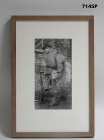
The Grinton Collection. Jack Grinton with full marching order kit on Refer Cat no. 1280 for Jacks service details.Photograph framed. Photograph - black and white photograph on paper depicting a full length informal portrait of a soldier with all his kit. Background - brick wall. Frame - timber, light varnish finish, Perspex front, cardboard backing."Group 1: Living behind the lines" "D. Kitted up".framed accessories, camera on the somme, ww1, 38th bn, grinton -
 Phillip Island and District Historical Society Inc.
Photograph, 1960's
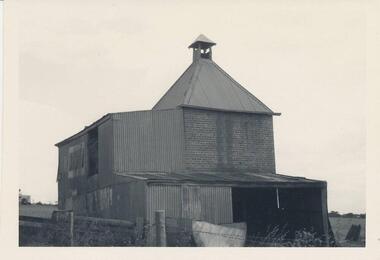
Donated by N. M. & J. D. Archibald. April 1973Black & White Photograph. Chicory Kiln. Cowes - Mr. P. Forrest, Jnr. Brick with Iron structure in parts. The Kiln was used for processing for other people. Built by Mr. H. Bennell about 1912. Chicory Kiln Album.local history, photography, photographs, agriculture buildings, historic, chicory kiln, cowes, phillip island, p forrest jnr, h bennell, n & j archibald -
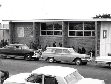 Glenelg Shire Council Cultural Collection
Photograph, Portland Wool Exchange, n.d
Port of Portland AuthorityFront: (no inscriptions) Back: 177 (centre, pencil)port of portland -
 Glenelg Shire Council Cultural Collection
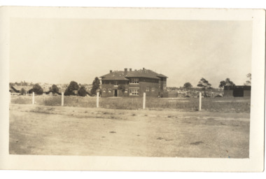
Photograph - Photograph - Portland Higher Elementary School, c. 1923
Portland Higher Elementary School, with an enrolment of 30 students, was established in 1912 as part of the Palmer Street Primary School. Senior education continued on this site until 1945 when Portland High School was finally established with 192 students. By the time new buildings were built in Julia Street in 1957 and ready to move into, there were already 480 students enrolled. The school continued to grow until 1969 when the enrolment was 800 students.Black and white photo. Higher Elementary School Portland, possibly 1923. Group of students posed outside brick building ?Palmer St; girl in front row holding sign with 'H.E.S. PORTLAND FORMS C. D. E.'Front: 'H.E.S. Poss. 1923' - biro, top left mount. 'G.V. BOLTON PHOTO ARTIST' - embossed bottom right mount' Back: 'POSSIBLY 1933 VIVIAN' handwritten, blue biro and names of people in photo - blue birosecondary school, portland high school -
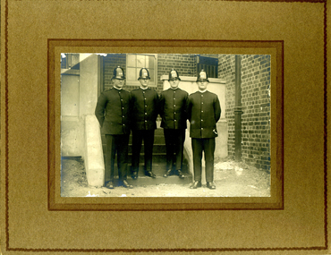 Victoria Police Museum
Photograph (Victoria Police Group Photo), Police Officers group in depot, 1920s
Black and white photograph mounted on light brown frame. 4 Police Officers in 1920s uniform pose in uniforms with helmets. Standfing in a terrace with an open brick house with windows and a set of stairs on the background. On the right is William Arthur Poulter.Handwritten: ON THE RIGHT SIDE // 8060 // W.A. POULTER Stamp: PHOTOGRAPH TAKEN // AT YOUR OWN HOME // P. J. DWYER // Onr. Harding & Salisbury Sts. // COBURG // PHOTOGRAPHS COPIED // AND ENLARGEDpoulter, william, william arthur poulter, victoria police museum, dwyer, p. j., police officers -
 Ringwood and District Historical Society
Photograph, Photos of last houses to face demolition at Camberwell. c1970s, c1983
One of the last houses to face demolition.Single fronted weatherboard with striped veranda blind, brick chimney over front rooms with TV aerial. Green painted walls. Red painted iron roof over veranda and under veranda rail. Adjacent to Target entrance.The 'Miss Stayput' house in the car park out the front of Target in Camberwell. You can even see the Target logo on the building. The house was owned by Mary Campigli, who defied the council order to move, and won her case in court. She stayed in the house, surrounded by a car park until she died in 1983 at the age of 94. The house was finally demolished soon after. -
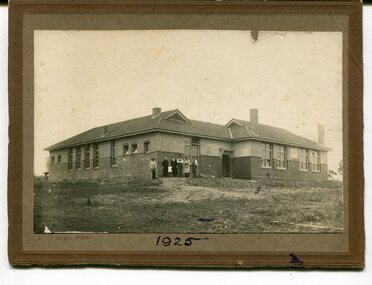 Orbost & District Historical Society
black and white photograph, C1925
This is a photograph of the Orbost High School in 1925. It has been identified by Mary Gilbert.Orbost High School / Orbost Secondary College has played a significant part in the education of senior students in the Orbost district . It is the sole senior educational institution. This photograph is representative of its history.A black / white photograph mounted on brown card. It shows a large building surrounded by bare earth. There is a group of six adults and a child standing at one corner of the building. The building is made of bricks topped by stucco and has a tiled roof. on front bottom -1925 on back - Orbost High School 1925education-orbost-high-school -
 Federation University Historical Collection
Photograph - Image - Colour, Federation University Arts Academy from Ballarat Trades Hall, 2016, 30/07/2015
Federation University Arts Academy buildings fronting Camp Street Ballarat. The cream brick building is the former State Officer, the red building is the former Ballarat Court house, and the grey blue building was custom made for the Arts Academy.arts academy, camp street, former ballarat state offices, former ballarat court house, ballarat trades hall -
 Federation University Historical Collection
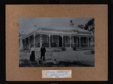
Photograph - Black and White, Carngham-Snake Valley Presbyterian Manse
The former manse is located at 954 Linton-Carngham Road. According to the donor these image copies were used in an exhibition, and distributed at the conclusion. The originals are thought to be in the collection of Snake Valley HIstorical Society.Black and white photograph mounted onto strawboard showing the a brick building with iron lace work around the verandah. It is the Cargnham-Snake Valley Presbyterian Manse, and the Rev. J.S. Drummond, his wife and two children are featured in the foreground. snake valley, carngham, j.s. drummond, presbyterian manse -
 Federation University Historical Collection
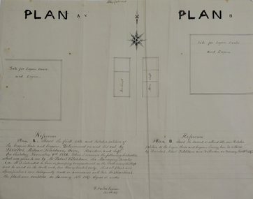
Plans, Site for Engine House and Engine, 1887
Two ink plan drawings, one with brown and grey shading, showing proposed sites and relative positions for an engine house and engine. .1) shows Plan A and Plan B options .2) shows elevations of brick engine houseengine house, robert ditchburn, w. watson, plans, mining -
 Bendigo Historical Society Inc.
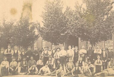
Photograph - WORKERS IN FRONT OF THE HORWOOD BROS FOUNDRY
Sepia photograph of the workers at the Horwood Bros foundry. Four rows of workers, some sitting some standing in front of a brick building, arched windows, main entrance centre of image. On window on RH side is the Horwood Bros name.industries, steelmaking, horwood's foundry -
 Bendigo Historical Society Inc.
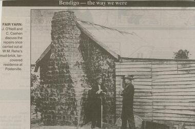
Newspaper - JENNY FOLEY COLLECTION: FARM YARN
Bendigo Advertiser ''The way we were'' from 2000. Fair yarn: J. O'Neill and C. Cashen discuss the repairs once carried out at W.M. Rehe's mud-brick, tar-covered residence at Fosterville. The clip is in a folder.newspaper, bendigo advertiser, the way we were -
 Bendigo Historical Society Inc.
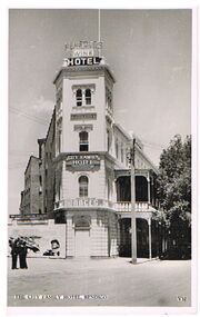
Postcard - BENDIGO HOTEL COLLECTION: CITY FAMILY HOTEL
Black and white photo: Two storey rendered brick building, City Family Hotel,1 High Street, Bendigo, showing two storey verandah. Written on front of hotel 'Wine Hotel' and ' City Family Hotel' and 'Races'.buildings, hotel, city family hotel, city family hotel, bendigo, charing cross. -
 Bendigo Historical Society Inc.
Photograph - FOSTER AND WILSON COLLECTION: PHOTOGRAPH
Black & white photograph of a group of men outside a brick building. Some of the men are wearing caps with V. R. on the front. They are wearing suits or uniforms. Some at the front are sitting on a low trolley. There are rail lines at the left edge of the photo.F. Harrison. 161 Lyttleton Terrace, Bendigophotograph, portrait, group, foster & wilson collection, photograph -
 Bendigo Historical Society Inc.
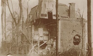
Postcard - ACC LOCK COLLECTION: LAGNICOURT POSTCARD, 1914-1918
Postcard, WW1, Sepia image of a partially destroyed 3 story brick house at Lagnicourt, France. Near corner blown away exposing intreior. G32 and GS handwritten in pencil on the back. See also another copy 1401.22postcard, postcard, ww1, lagnicourt, france -
 Bendigo Historical Society Inc.
Photograph - HARRY BIGGS COLLECTION: HAIR DRESSING SALON, C. 1960's - 70's
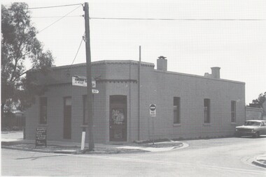
Photograph (proof 47A) of a flat roofed brick building (possibly an old hotel ?) on the corner of Dunlop Lane, Kangaroo Flat. There is a 'Runciman Hair Design' Ph. 47930' sign on the side of the building, and a board out the front advertising the business.buildings, commercial, hair salon, kangaroo flat, dunlop lane, runciman hair design -
 El Dorado Museum Association Inc.
Photograph - Digital Image
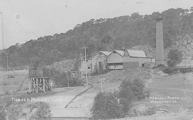
Cocks Pioneer Power Station No 1. Cocks Pioneer Electric Gold & Tin Mine Company was formed in 1899. The company's first power station, located at the eastern end of the valley began operating with its 340 Kilowatt steam-powered generator. By 1909, from 2 500 000 cubic yards worked, reported recovery was 17 284 ounces of gold and 224 tons of tin ore. By 1909, Cocks Pioneer’s power plant had become inadequate and uneconomical. The barge was floated downstream about a mile, but lost time caused the operations to cease. Following testing, a new mine was established by diverting Reid's Creek at a cost of £25 000. Settling dams were built, one of which held 1 935 900 cubic feet. Sold earth banks, built against a wall of stringy bark saplings constructed and laced with vertical props, were built. In 1914, the company was reformed as Cock’s Pioneer Gold and Tin Mines NL, another power station was constructed at the western end of the township, near the junction of Clear and Reid's Creeks. From 6,800,000 cubic yards of material processed, the returns were 64 397 ounces of gold and 855 ton of tin. Cocks Pioneer mine then moved the barge downs stream and continued sluicing. In 1929 Cocks Pioneer Electric Gold and Tin Mining Company ceased operations due to a drop in values. Cock’s Pioneer Gold and Tin Mines NL carried on large-scale hydraulic sluicing operations until 1941. Handrwitten on right side of image: PIONEER MINE ELDORADO Handwritten on left side of image: AJ EVANS PHOTO / WANGARATTAmines, mining, gold, tin, gold mining, tin mining, sluicing, hydraulic mining, energy, power station, cocks pioneer, el dorado, eldorado -
 Clunes Museum
Photograph
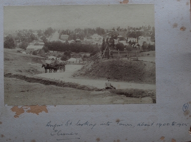
BLACK AND WHITE PHOTOGRAPH TAKEN FROM BRICK HILL, FACING SOUTH, HORSE DRAWN HAY WAGON AT SIDE OF ROAD. GAS LAMP, POST AND RAIL FENCE. POST OFFICE, TOWN HALL, ES&A BANK,STATE BANKANGUS STREET LOOKING INTO TOWN, ABOUT 1900 TO 1905 CLUNESlocal history, photography, photographs, clunes township -
 Clunes Museum
Photograph, TESLA - 244 CHAPEL ST. PRAHAN VICTORIA, 8.9.06
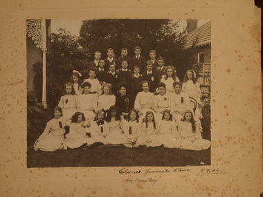
MISS FLO PERRY CONDUCTED CHOIRS IN CLUNES AND WON MANY CONTESTS..1 BLACK AND WHITE PHOTOGRAPH, MOUNTED ON CARDBOARD - GROUP OF BOYS AND GIRLS, MISS PERRY IN THE MIDDLE. BRICK HOUSE, TILED ROOF ON RIGHT OF PHOTOGRAPH - LACE WORK ON VERANDAH POST ON LEFT. .2 BLACK AND WHITE PHOTOCOPY OF THIS PHOTOGRAPH CLUNES JUVENILE CHOIR. MISS FLORENCE PERRY.local history, photographs, choirs -
 Stawell Historical Society Inc
Photograph, Congregational Church in Scallan Street Stawell
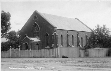
Postcard original Congregational Church Scallan St. Stawell with picket fence and double gateway. Postcard No 21. The church in this photograph was built in 1874 and opened on Sunday September 13th. The Rev. S.C. Kent, of Melbourne was the Preacher. The building was intended to accommodate 250 people. The cost, exclusive of the land was 800 pounds. The building was designed and supervised by Rev J.G. Wilson. The Church was the first to be lit with gas in Stawell. Note gas light on the porch. This building is now used by the Lutheran Church.One post card of a church with 3 enlarged photos of the post card. The image is the Congregational Church in Stawell. The church is brick with a picket fence and double gateway with a black dog lying beside the gateway. Enlargements donated by Congregational Church.Congregational Church Stawell 21. (On the back) Empire post card real photograph by T. R. G. Williams Araratstawell -
 National Wool Museum
Photograph, Union Mill, 1932
The Collin's Union Mill was built in 1874 making it one of the first Woollen Mills in Geelong. The building was upgraded in 1910 and 1940. The two photos are of the same location within the mill at different years, showcasing the upgrade to the mill.The first photo is a black and white image alleyway in the Union Mill in landscape format. A pile of bricks are stacked on the right hand wall. The second photo is a sepia image of the same alleyway, showcasing the second floor upgrade to the left building.8064.1 - on rear - Union Mill 1932wool, woollen mills, geelong, wool manufacture, union mills, collins -
 Ballarat Heritage Services
Photograph, Clare Gervasoni, Daylesford Uniting Church, 18/10/2015
A red brick church on stone foundation in Daylesford, a hall, and a former church. The small building at the centre is the John Mitchell Memorial Hall named after a teacher and superintendent from September 1861 to 1921. It was still in existence in August 2024. daylesford uniting church, daylesford methodist church, daylesford -
 Bendigo Historical Society Inc.
Photograph - BENDIGO HOTEL COLLECTION: VICTORIA HOTEL, EAGLEHAWK
Colour photograph, Victoria Hotel,Corner High and Victoria Streets, Eaglehawk. Two storey hotel, rendered brick, iron lace trimmed verandah on both levels with gable on corner, top level. Appears to be early 70's ?bendigo, hotel, victoria hotel eaglehawk -
 Buninyong & District Historical Society
Photograph - B/W photograph of old Buninyong Post Office, brick building, built 1873, north side of Learmonth St. west, Mr. C.J. Brooks, Old Buninyong Post Office, Learmonth St. Buninyong, 1993
Former Buninyong Post Office opened in October 1873 and closed in 2000, converted to residence weel preserved C19th public buildingB/W photograph of L-fronted polychrome brick building, slate roof, picket fence, covered verandah left side, three arched windows right side, Post Office sign above, telephone booth to the right.streetscape, building, brick, post office, learmonth st, buninyong -
 Kew Historical Society Inc
Photograph - Photographs, Former Baptist Church, Woodlands Avenue, Kew East, 2018, 2018
The former Baptist Church, at 8-12 Woodlands Avenue, Kew East, was nominated by the Society for protection as part of the Kew East Heritage Gap Study. W D Vaughan in his 'Kew's Civic History' (1960 writes that: "With the development of East Kew, local Baptists considered the establishment of a church was necessary. A block of land was purchased in Woodlands Avenue and the foundation stone of a new church was laid on August 8, 1931. A fine Sunday school has since been erected, and special emphasis has been given to providing activities for the young people of the church"Three colour photographs of the former Baptist Church in Woodlands Avenue, Kew East. The photographs are of the front and side of the clinker brick building. One of the photographs shows the foundation stone, laid by AH Lewis Esq, 8 August 1931.churches - kew (vic), baptist church - woodlands avenue - kew (vic) -
 Kew Historical Society Inc
Postcard - Kew East State School No.3161, 35 Kitchener Street, c.1927
What is now Kew East Primary School was opened on its current site in Kitchener Street in 1923. The Kew East and Mont Albert Heritage Gap Study (August 2020) established that: 'Kew East Primary School No. 3136 is historically significant for the evidence it provides of an early phase in the development of Kew East which gathered momentum from the 1920s, as housing developed rapidly and the population increased in response to the extension of the High Street tram to Harp Road then Burke Road then improved tram connections between the area and the city.'A rare and early photograph of the school taken four years after its construction. Small, sepia coloured photographic positive of East Kew State School. The two storey red brick building was opened in 1923. This view, three years after its construction shows preliminary fencing and undeveloped playing grounds.schools -- kew east (vic.), government schools -- kew -- kew east, strathalbyn street -
 Queen Victoria Women's Centre
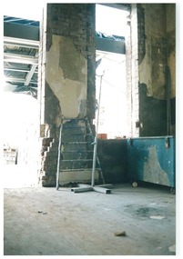
Photograph, August 1996
Colour photograph. Ground floor looking east formerly the administration offices into what was to be the cafe and in 2015 is the Breacan office. Ladder leaning against brick wall. Blue locked trunk left of frame, Taken during restoration inspection. historic buildings, building construction, cultural structures and establishments -
 Surrey Hills Historical Society Collection
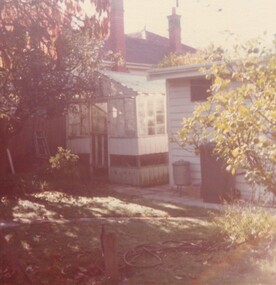
Photograph, 5 York Street, Mont Albert, May 1985 (2), 1985
This is the home of Ernest Augustus Young (1891-1985) and Ruby Nichell Whitby (1892-1984) and their son Ernest Lance Young. Lance was born 24 March 1915 in Surrey Hills; after he married Beryl Mair. Electoral roll for 1937 gives the house name as 'Whitby Lodge'. Ernest and Ruby also had twins Clive and James who died in infancy. Buried at Box Hill Cemetery - M-*-0867 (family plot) This is part of a large collection relating to the Mair, Deakin and Young families. REF: Memoir of Laurie Newton (nee Young) - Her grandfather bought the land and had the house built. She remembers it as having pressed ceilings in some rooms and ornate fireplaces and tiles and leadlight windows in some rooms and doors with leadlight panels. Her grandfather was a keen gardener with an ornamental front garden and many vegetables and fruit trees in the back yard. Her grandfather sold the adjoining block (No 3 York Street), which had been used for growing flowers and vegetables, to John and Edna Jean. Reid. She also remembered that he extended the house and divided it into 2 flats, renting out the northern side for 20 years. Sold by Jellis Craig on 24 December 2010 - With formal living, dining, 3 bedrooms, 2 bathrooms, garage/ample OSP. Land: 18.2m x 40.8m (60' x 134') approx. Large 2 storey house replaced the house. Adjacent house (No 7 York Street) has been renovated. Colour photo of a rear view of 5 York Street, Mont Albert. Only part of the house can be seen but part of the roof of the house next door and brick and stucco chimneys can be seen. There is a greenhouse between these 2 properties.Red photographic processing stamp "PROCESSED BY / KODAK / MAY 85M"ernest augustus young, ruby nichell whitby, ruby nichell young, ernest lance young, box hill cemetery, whitby lodge, house names, mont albert