Showing 2831 items
matching fences
-
 Glenelg Shire Council Cultural Collection
Postcard - Postcard - Casterton, Victoria, c. 1946
SOURCED FROM CASTERTON TOWN HALL (FORMER SHIRE OF GLENELG)Black and white photo postcard. Casterton 1946 flood. Man in overalls in foreground behind barbed wire fence, several 44 gallon drums. Buildings on left, tractor towing horse float, whole area flooded, no dry land visible.Back: Purple stamp 'POSTCARD' Purple photographer's stampcasterton, flood, 1946, tourism -
Glenelg Shire Council Cultural Collection
Photograph - Photograph - Henty Beach, Portland, 1950s
Black and white photo of small children in bathers on Henty Beach, Portland. Children standing on wooden stage in front of ramp. Bunting on ramp fence and hanging from stage. Brass band in foreground. Possibly Goldraiders bathing competition, summer 1950s.Back: 350-32 - pencilportland photography, bathing competition, henty beach -
Glenelg Shire Council Cultural Collection
Print - Contact Print, 1960-1979
Sheet of 2 contact prints from glass plate negatives. Top: Weatherboard house with return verandah, picket fence. 3 people in garden. Bottom: Seascape, Blacknose Point, Cape Grant. Woman with horse and buggy on cliff top, foreground. -
 Halls Gap & Grampians Historical Society
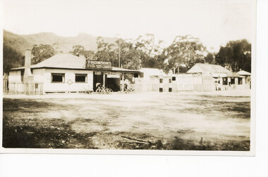
Photograph - Sepia, C 1921
Stores in Halls Gap.The photo shows a shop (with Thomson's Cakes" on a sign on the roof) with four bicycles at the front. There is a man standing behind the bikes. To the right of the shop is a fence, with an Atlantic Petrol sign attached to it and two petrol pumps in front of it. Further to the right is another store/cafe.buildings, shops -
 Glen Eira Historical Society
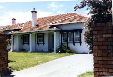
Photograph, Murrumbeena Road, 220, Murrumbeena, 2001
Originally labelled "Beauville Estate, Established 1936, Still Thriving 65 years on, 10th March 2001", the Beauville Estate Album contains colour photographs of houses in the Estate. They were taken around the time of the Beauville Estate’s 65th Heritage Celebration held on 10/03/2001 and donated to the Caulfield Historical Society shortly afterwards. Photographer unknown. No. 220 is NOT covered by the Heritage Overlay HO12 but the property has a number of similar features to those in the Estate.Colour photograph of a white rendered brick house with leadlight windows. Other features include a columned porch, striped awnings, black frames around the windows, chimneys, tiled roof and a high unpainted variegated brown brick fence beside the driveway.murrumbeena, houses, 1930's, inter war style, a.v. jennings, av jennings, jennings, brick houses, beauville estate, porches, lead lights, stained glass, murrumbeena road, architectural features, jennings group limited, land subdivision, brick features, brick walls, chimneys, striped awnings -
 Glen Eira Historical Society
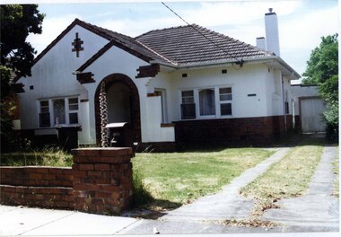
Photograph, Dalny Road, 9, Murrumbeena, 2001
Originally labelled "Beauville Estate, Established 1936, Still Thriving 65 years on, 10th March 2001", the Beauville Estate Album contains colour photographs of houses in the Estate. They were taken around the time of the Beauville Estate’s 65th Heritage Celebration held on 10/03/2001 and donated to the Caulfield Historical Society shortly afterwards. Photographer unknown. City of Glen Eira’s Heritage Management Plan Vol 2 p79 (this is p84 of the pdf version) – HO12 Beauville Estate and environs, Murrumbeena: The Beauville Historic Area is important at the State level as the first large housing estate undertaken by the AV Jennings Construction Co, later Jennings Group Limited, Victoria’s largest home builder. It is important also as a very early estate development incorporating a range of features other than houses and including made roads, shops and recreation facilities. In this respect it was the forerunner of the comprehensively planned housing estate of the post war era. The estate is distinguished by its aesthetic values, as is the earlier and comparable Hillcrest Estate, which are formed by a combination of restrained diversity in house styles, with the exception of no. 30 in the emerging International style, and by a landscaped garden environment. Colour photograph of a rendered brick house with unpainted decorative variegated brown brick features. Other features include tiled roof, chimneys, sash windows, concrete driveway, garage, porch with an arched entrance and a low unpainted brick fence in the foreground. murrumbeena, houses, architectural styles, 1930's, inter war style, a.v. jennings, av jennings, jennings, brick houses, beauville estate, dalny road, porches, sir albert victor jennings, a v jennings construction co, beauville estate heritage area, glen eira city council, architectural features, jennings group limited, land subdivision, beauville historic area, brick features, chimneys, garage (private), arches, sash windows, rendered houses -
 Bendigo Historical Society Inc.
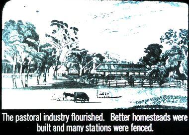
Slide - DIGGERS & MINING. THE GOLD ERA, c1850s
Diggers & mining. The gold era. The pastoral industry flourished. Better homesteads were built and many stations were fenced. Slide shows some of the fencing and shelters added to homesteads. Markings 56 994.031 GOL:5. Used as a teaching aid.hanimounteducation, tertiary, goldfields -
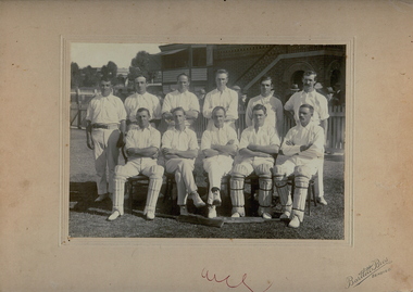 Bendigo Historical Society Inc.
Photograph - ?B.U.C CLUB, CRICKET TEAM
B+W photo of cricket team. 11 men in cricket gear, 3 at front wearing pads. In background are part of grandstand, fences, trees, and part of building with sign reading : '?B.U.C Club Harold Williams left end back row?'Bartlett Bros. Bendigoorganization, club/society, ?b.u.c.club, cricket club, james lerk ' cricket team b.u.c.c upper reserve, bendigo', helen mamka 9.11.2001 'this photo is not in ken wust's book: bendigo district cricket 1953-1990 -
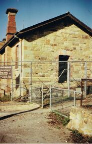 Bendigo Historical Society Inc.
Photograph - I WILLIAMS COLLECTION: POLICE BARRACKS
Collection of photographs -Mr I Williams , 9 Monreith Ave 21.3.84 - photograph of Police Barracks, located in Rosalind Park, showing renovation work. Wire fence surrounding stone building. MR I WILLIAMS , 9 MONREITH AVE 21.3.84photograph, building, collection of photographs -mr i williams , 9 monreith ave 21.3.84 -photograph of police barracks -
 Bendigo Historical Society Inc.
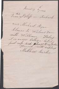
Document - ANCIENT ORDER OF FORESTERS NO. 3770 COLLECTION: CORRESPONDENCE
Note written on cream paper and dated January 11th, 1872. Dear Istop in Ironbark. Neer Michael Ryan. Cloase to Watsons Dam with William Foley it is anew Cotage lately put up and cloase to garden fenced with saplings. Matthew Burke.societies, aof, correspondence, ancient order of foresters no. 3770 collection - correspondence, islop, michael ryan, watsons dam, william foley, matthew burke -
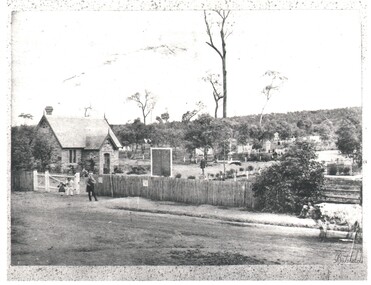 Bendigo Historical Society Inc.
Photograph - WES HARRY COLLECTION: BENDIGO CEMETERY, 1860's
Photograph of the Bendigo Cemetery showing some headstones among the trees. Caretakers cottage ?, Chapel ?, on the left of the shot with some children and an older man in front. There is a picket fence along the front of the cemetery and a cow standing on the roadway at the right hand edge of the photo.Batchelderplace, cemetery, bendigo cemetery, carpenter street, bendigo cemetery, batchelder -
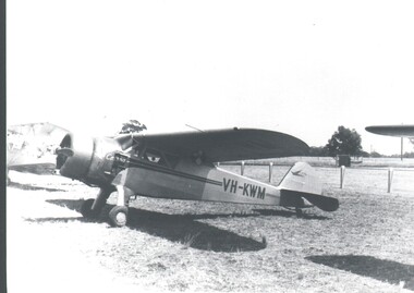 Bendigo Historical Society Inc.
Photograph - HARRY BIGGS COLLECTION:CESSNA AEROPLANE
Photograph of an early model Cessna Aeroplane at a rural airport, there are portions if two other planes visible beside it. A fence is in the background and a sign behind that which is Partially obscured, '--men', a man is standing in front of the sign. The registration letters on the plane are VH - KWMplace, transport, aeroplane, cessna , vh- kwm -
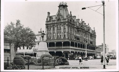 Bendigo Historical Society Inc.
Photograph - BENDIGO - SHAMROCK HOTEL
Photograph - black and white. Photo of Shamrock Hotel, Bendigo, war statue in centre. (number written on left hand side No.24). Soldier memorial left of centre. Iron fence surrounds lawn and shrubbery, old toilet block extreme left.buildings, hotel, shamrock hotel., shamrock hotel, bendigo. -
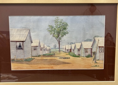 Tatura Irrigation & Wartime Camps Museum
Painting - Painting - Water Colour
Glunkler was interned in Camp 3Water colour of two rows of huts. Each row has eight huts with the windows open. There is a single gum tree in the centre between the two rows and some tree in the background beyond a fence. Small gardens with stone edging are around the huts.Glunkler 1943 -
Tatura Irrigation & Wartime Camps Museum
Photograph, 22 September 1991
Photographed at the German War CemeteryColour photograph of a large group attending a service at German section of Tatura Cemetery. 22 September 1991. Deiter Ruff (Templer Society) speaker. Two large gum trees dominate the photo with a couple of boxes in front of the chain wire fence.tatura war cemetery, deiter ruff, templer society -
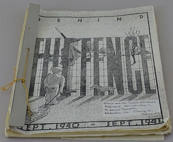 Tatura Irrigation & Wartime Camps Museum
Book, Behind the Fence, 1941
Made by internees, Singapore Group Refugees at Camp 3 Tatura for entertainment purposesSoft cover loose leaf book "Behind the Fence" Sept 1940 - Sept1941. 12month periodical. Has camp sketch on front cover. Written (typed) in English and German. Black & White illustrations and sketches. Card cover bound with coloured thread.tatura, singapore group camp 3, books, history, local -
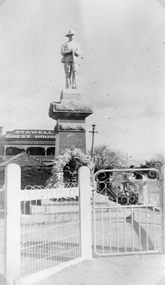 Stawell Historical Society Inc
Photograph, Soldiers’ Memorial World War 1 in Main Street in front of the Stawell Guest House
Soldiers’ Memorial WW1 with the Stawell Guest House (Coffee Palace formerly Castlemaine Hotel) and roof of weighbridge in the background. The photo is a copy of the original owned by Mrs. Gwen Reeve. Black and white photograph of the WW1 Soldiers Memorial with a large floral wreath at the base. The photo shows the gate and fence Infront of the memorial. The Stawell Guest House also called the Coffee Palace and roof of the Weighbridge can be seen in the background. c.1935stawell ww1 -
 Stawell Historical Society Inc
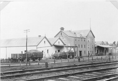
Photograph, Wimmera Flour Mill with adjoining Buildings c1920s -- 2 Photos --1 Coloured
2 photos of three story flour mill and adjoining buildings 1920's.Two photographs of railway tracks in front of the Stawell flour mill and adjoin buildings. Two people are standing in front of the three story flour mill with a timber fence along the railway tracks and a telephone pole in front of two of the four rail wagons. stawell industry -
 Stawell Historical Society Inc
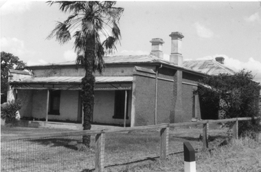
Photograph, Brick Home at 9 Seaby Street -- 2 Photos
Brick Home 9 Seaby Street originally built by Crothers Family. Now owned by Mr. and Mrs. Peter Carey, The house is located on the corner of Luke and Seaby St. This house was imported from Canada. All components are numbered. It has a cavity wall construction. The present owners have carefully restored this house.Two black and white photograph of a large brick home. Roof is corrugated iron with a veranda across the front. A large palm tree in front. Fence along the side is wire mesh with timber supports. The second photo is a closer side view of the house. stawell -
 Whitehorse Historical Society Inc.
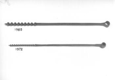
Tool - Auger Bit
Long steel shaft half of which is twisted into a corkscrew shape and sharpened to make a hole in wood. The other end has been formed into a round hole so that a handle may be inserted to turn the drill. Used for drilling hole in fence post.rural industry, fencing -
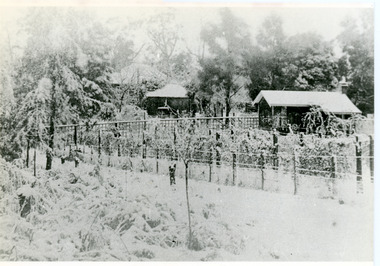 Mt Dandenong & District Historical Society Inc.
Photograph, Erith Lane
Erith Lane would have been named after Eliza Erith, the wife of Thomas Hand of Mountain Grange. The house made of slabs and bark pictured (centre) is where the family lived before Mountain Grange was built. Mabel Hand, Thomas and Eliza's youngest daughter stated that she was born in the bark hut in 1881 and they moved into the new home the same year. Cherry Farm, the roof visible behind the centre building, was the home of William Hand, son of Thomas and Eliza. He lived here with hs wife, Harriet Toghill, before moving to live at Mountain Grange after 1905.Black and white photograph showing a scene under heavy snow. Two cottages and a rooftop visible. Snow laden vines forming the front fence. Taller trees visible in the background. Reverse of photograph has handwritten description by John Lundy-Clarke.Erith Lane under snow. House in passion fruit Ivory’s holiday home 1921. Building in centre was Hand’s 28’ by 22’ house of slabs and bark. The first house on top of the whole Dandenong Range built 1871. Large roof behind it was “Cherry Farm”.eliza erith, eliza hand, mabel hand, thomas hand, william hand, erith lane, kalorama, snow, mountain grange, cherry farm, harriet toghill -
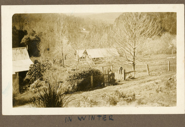 Mt Dandenong & District Historical Society Inc.
Photograph
The photograph is from the album of Ivy Child. The buildings form part of the Child family farm where Ivy Child lived with her parents Ted and Ethel Child. The photograph is taken in winter with the trees devoid of leaves. Ivy May Child (1910 – 1989) was the daughter of Arthur Edward (Ted) Child (1878 – 1964) and Ethel May Madden (1888 – 1970). Ted Child was the son of Matthew Francis Child (1839 – 1933) and Martha Jeeves (1857 – 1926). He was the grandson of one of the early pioneers Francis Child. Ivy grew up on the family property on Childs Road and took many photographs. Most of these are glued into her photo album. The album covered the years from c1927 – 1932. Ivy married Henry William Burgess (1906 – 1968) in 1944. The photographs remain in their original state in the album with individual copies made. Sepia photograph showing a group of buildings - a homestead and sheds. There is a wire fence and gate at the front. A woman wearing a hat is about to go through the gate. She is carrying a suitcase. Trees and bushes surround the property and a cleared area and rooftop are visible in the distance.Handwritten below the photograph in album: IN SUMMERivy child, child, winter, ted child, ethel child -
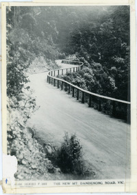 Mt Dandenong & District Historical Society Inc.
Photograph, The New Mt Dandenong Road, Vic
Copy of Rose Series postcard #385 showing the new Mt Dandenong Tourist Road with wooden railing fence on low side of road. Surface not yet made. This photograph has a detailed inscription on the back handwritten by John Lundy-Clarke in 1974.View downhill from the Windy Bend showing the site of the 1972 landslide. In this picture the road is running along the top edge of the wall 900’ thick of Kalorama Docite that plunges thousands of feet deep down into the earth below the Ranges and extends to Fern Tree Gully. It was once a horizontal terrace nearly ten miles square and tipped over to the left when the mountain subsided into its volcanic cauldron.mt dandenong road, rose series, windy bend, landslide -
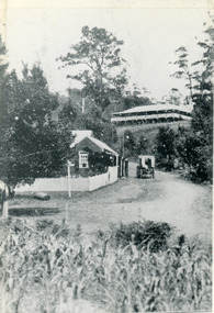 Mt Dandenong & District Historical Society Inc.
Photograph, The Gap at Kalorama 1913, 1913
1913 scene looking up to Mountjoy Guest House at the Kalorama Gap (FiveWays). Post Office and tea rooms with white picket fence. Jeeves Coach on the road. This photograph has a detailed inscription on the back handwritten by John Lundy-Clarke in 1974. The Gap Kalorama 1913. ‘Mountjoy’ guest house. Mount Dandenong North Post Office. Jeeves coach.fiveways, mountjoy, post office, mt dandenong north, the gap, jeeves, coach -
 Kew Historical Society Inc
Photograph - Street Works, Studley Park Road, March 1934
Studley Park Road, like most streets in Kew, was originally a dirt road. Street works during the Great Depression included bituminising major roads in the district. This photograph of Council works originated in the City of Kew Engineers Department as a record of works undertaken. It was given to the collection by a Mrs Fisher in 1998.Well provenanced photograph of Council-funded public works in Kew during the Great Depression. Original sepia photographic positive of Studley Park Road, Kew while resurfacing of the street was taking place. The Kew Junction is just visible in the distance. Boys sitting on a drum at right. Behind them is the brick fence and front entrance to Tara Hall.Typed reverse: "B4 / Kew C.C. / Studley Park Road showing drag spread surfacing with premixed material, unrolled material on the right, March 1934"roadworks -- kew (vic.), street works -- kew (vic.), public works kew (vic.), studley park road -- kew (vic.), city of kew -- engineers department, city of kew -- public works -- great depression -- 1930s -
 Surrey Hills Historical Society Collection
Photograph, 34 Union Road, Surrey Hills - home of the Kleinert family
This was built in 1905 and was the home of William and Emily Kleinert from 1905. William was a coach-builder, wheelwright and blacksmith. He moved from Prahran to Surrey Hills. His son Ernest worked with him as a coach painter and also worked as a painter undertaking intricate hand painting on early cars. Their other son Martin played for the Surrey Hills Football Club. In return for the support given to the club by Mrs Emily Kleinert, the club built a rotunda in South Surrey Park as a memorial to her. Alan Holt research: Lot 6 was sold to Martin Kleinert by Karl Richter in 1860 together with a portion of another adjacent lot. From 1860-1885 Martin worked it as a market garden leasing some land for grazing when it was not required for gardening. He died in 1898. In a formal document, William declared he was the son of Martin "who purchased land in 1860, died in 1898 and the land has been continually occupied by father and family since. It has been cultivated as a market garden; when not being used for gardening it was let for cultivation and grazing." William died in 1939 and the property passed to his sons Martin and Ernest. The Kleinert land extended from Union Road to Essex Road. They ran horses, ducks and fowls and Emily Kleinert grew flowers. The Kleinert property later became the South Surrey Park. The family sold the land to the Camberwell Council in the 1950s. Ernest and Ida Kleinert lived on the corner of Scotsdale and Warrigal Roads. The donor of the photo Nada Harris, nee Kleinert, was Ernest and Ida's daughter. Ida lived to a good age (> 93 years) and in later life lived in Burwood.Black and white photo of a Victorian cottage with a typical bull-nosed veranda. It is set behind a wooden picket fence with undeveloped grazing land studded with mature trees in the background. Taken front-on from the street. There appears to be a path but no formal curb to the road.south surrey park, union road, surrey hills football club, blacksmiths, wheelwrights, coachbuilders, rotunda, miss nada kleinert, mr william kleinert, mrs emily kleinert, mr martin kleinert, mr ernest kleinert, mr karl richter, mrs ida de vasy, mrs nada harris -
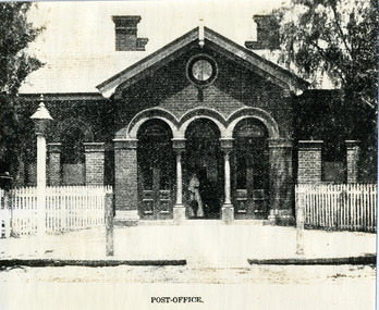 Charlton Golden Grains Museum Inc
Photograph, The Australasian, Charlton Post Office c. 1910, c,1901
Charlton Post Office High Street built 1879 to replace the original small post office built in Camp St in 1878. Possibly copied from a photograph in the Weekly Times or the Leader c. 1910Poor quality copy of photograph. Brick building with three arched doorways. Woman in long frock carrying an umbrella standing in central doorway. White picket fence and lamp on footpath. Two posts on footpath. Possibly a clock above the central doorway.charlton post office, charlton, business, industry -
 Lakes Entrance Historical Society
Photograph - St Joseph's Swan Reach, 2003
Believed built 1909 (information from Leo Howlett).Colour photograph of St Josephs Catholic Church, Princes Highway, showing a typical small timber Edwardian Church, gable roof and gable entry porch. Four ventilators through pitch of roof. Wire lace fence. Swan Reach Victoriareligion, buildings -
![Book - Novel, Sandys, Oliver (pen-name of Marguerite Florence Laura Jarvis), Singing uphill, [n.d.] [194_?]](/media/collectors/641920217f0478323d8a47a8/items/65430acdf11bd0375b7bc25a/item-media/654f015ae64ed8bdfc17df2f/item-fit-380x285.jpg) Linton Mechanics Institute and Free Library Collection
Linton Mechanics Institute and Free Library CollectionBook - Novel, Sandys, Oliver (pen-name of Marguerite Florence Laura Jarvis), Singing uphill, [n.d.] [194_?]
220 p.; red cover, original dust jacket has been removed, a section of it has been pasted to the front cover. This depicts a man and a woman near a farm fence, with a lamb in the woman's arms. Title and author's name handwritten on spine.fictionfiction, oliver sandys -
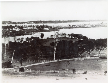 Lakes Entrance Historical Society
Photograph - Lakes Entrance, 1935c
Enlarged from postcard produced for Mrs Allen to advertise Allen's Tearoom at the brow of Myer St hill, known as Allen's Hill to locals.|This is the paired before photograph showing the left hand side on Butchers paddock in the panoramic views, the right hand side number 01715. This photograph used in the 150 year Lakes Entrance 1858-2008 display.Black and white photograph of the township, taken from Allen's Hill, Myer St. It shows the town between Cunninghame Arm and North Arm, cleared and fenced paddocks in foreground, New Works village and sand hummocks in distance. Lakes Entrance Victoria township, waterways, topography