Showing 3733 items
matching street map
-
 Port Melbourne Historical & Preservation Society
Mixed media, History of a Street Precinct
A cultural grant was given to Margaret BRIDE to implement this study, which she did with the help of her husband Graham and several residents of the study area including PMH&PS members Emily LOCK, David THOMPSON, Jack BOLT and Kerrie MATHEE.History of a Street Precinct, documenting 80 years plus of the history of the area bounded by Williamstown Road and Evans, Bridge and Farrell Streets, since 1880. One of two products of a 2005 project (which subsequently won the 2007 Victorian Local History Awards for research). An interactive CD containing information and photographs. This was packaged with a brochure (2148.01) containing a map of the area and photos and information on key properties and individuals on 91 buildings and their occupants over time.built environment -
Port Melbourne Historical & Preservation Society
Map, Port Melbourne Sheet 4, 1962
Framed line drawn map of Port Melbourne (sheet 4) 1962, covering the area from Beach Street (including Station and Princes Piers) to Plummer Street and Todd Road area to Dow Streetbuilt environment -
Port Melbourne Historical & Preservation Society
Map, Port Melbourne Sheet 1, 1962
Framed line drawing map of Port Melbourne (sheet 1) 1962, covering the area from Coode Canal to Plummer St and Todd rd to Boundary Stlocal government - city of port melbourne -
Port Melbourne Historical & Preservation Society
Programme - Port Melbourne Community Festival, Maree Menzel et al, Feb 2001
Poster and program promote the two day Festival organised by a community based committee under the auspices of the Port Melbourne Neighbourhood House.Program for the 2001 Port Melbourne Community Festival. Images of Port such as sail and ferry, in pink, blue and green, A3, folded to A6 and including full program of activities, coupons and mapcelebrations fetes and exhibitions, maree menzel, pat grainger, port melbourne neighbourhood house -
Port Melbourne Historical & Preservation Society
Book - Nation Builders - Great Lives etc, Meyer Eidelson, Nov 2001
This was a Centenary of Federation funded project launched 16.12.2001 at the cemeteryNation Builders - Great Lives etc.' by Meyer Eidelson. Soft cover, 120page book detailing principals of the Federation period who are buried at the St Kilda Cemetery. Fold out back cover has map of cemetery; illustrated.Signed by author, "For the Port Melbourne Historical and Preservation Society and their wonderful work. Meyer Eidelsondeaths and funerals, meyer eidelson, alfred deakin, sir ferdinand von mueller, federation -
 Port Melbourne Historical & Preservation Society
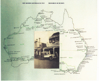
Photograph - Collage, Faram Brothers 1932 trip around Australia, 1932
Digital print of collage by Judy FARAM, with sepia photo of the Ford and Farams in front of Faram Bros., superimposed on map of their 1932 trip around Australia, in tones of green.transport - motor vehicles, business and traders - hardware, faram brothers hardware, judy faram, george faram, richard faram, herbert faram -
Port Melbourne Historical & Preservation Society
Document - Report, Plan of General Development, Mr J Green (Government Printer), Plan of General Development, 1929
Plan of General Development. Melbourne Report of Metropolitan Town Planning Commission, 1929. Was passed on by local history librarian as it was no longer required. On p63 shows view up Swallow Street and contrasts it with approach of St Kilda. P42 aerial view of Port Melbourne piers. Also includes maps and photographs.town planning, piers and wharves, swallow street -
Port Melbourne Historical & Preservation Society
Map - Photographic copy, Unidentified map of Sandridge, c. 1866
Photographic copy of an unidentified (Cox?) Sandridge map 1866 or later, with portions of West Melbourne, Emerald Hill and the Bend. Indicates bay and river soundings 'taken by Commander COX in 1866'. Original appears to have been torn and repaired; resultant lines whited out on copy.Fold lines have been whited out on back; '52'piers and wharves, transport - railways, built environment, maritime, beacons, sandridge lagoon, batteries - defensive, commander cox -
Port Melbourne Historical & Preservation Society
Programme, Programme of the Tour and Matches arranged for the First Visit of the Australian Women's Cricket Team 1937 to England, 1937
Material on cricketer Peggy ANTONIO: Photocopies of Programme of the Tour and Matches arranged for the First Visit of the Australian Women's Cricket Team to England in 1937. plus photocopies of test results and map of Australian Women's test cricket tour 1937sport - cricket, peggy howard nee antonio -
Port Melbourne Historical & Preservation Society
Manual, Collins Street Directory 1961, 1961
... This compact Collins Street Directory has 178 detailed maps and shows ...This compact Collins Street Directory has 178 detailed maps and shows postal district numbers used at that time.Small directory of Melbourne streets in 1961 including a separate map of all areas covered by the directory & their map reference numbers.built environment - civic, collins book depot {ty ltd -
 Port Melbourne Historical & Preservation Society
Document, Hotels in Port Melbourne
The letter on the outside of the sheet is from Jim (?) to Les (Turner). It gives some of his childhood recollections of Port Melbourne Hotels These include the Shamrock which he understood that it was "... a weatherboard Building - very Badly Conducted and when it was burned down it was not rebuilt... I did know that there was a murder there."Inside is hand drawn map of Port Melbourne with the hotels marked in position as well as a Key down the left hand side. The accompanying typed sheet lists the 50 original hotels on the left hand side and the 20 remaining on the right.A large ruled sheet of paper with a letter on the outside & inside a hand drawn map of Port Melbourne with the location of hotels marked. A typed sheet lists the hotels.Hotels of Port Melbourne. Originally there were 50. today there are 20.business and traders - hotels, shamrock hotel, leslie stanley turner -
Port Melbourne Historical & Preservation Society
Map, Fredrick C COOK C.E.L.S, City of Port Melbourne, Nov 1938
1/600 map of the City of Port Melbourne by City Engineer, Fredrick C COOK.Map of Port Melbourne, November 1938local government - city of port melbourne, fredrick c cook -
Port Melbourne Historical & Preservation Society
Map - Large map of Port Melbourne, British Chart, Japanese war-time map of Port Melbourne, c 1937
Jim Sinclair was born in Cruickshank Street, Port Melbourne in 1924. During World War II Jim found this map in a network of caves near Rabaul, Papua New Guinea. He remembers '"The Japanese] had linked just about every hill with a tunnel. Concreted. Most of them were packed with stuff. I used to wander through - being very careful too, mind you!. You didn't want yourself to get blown up. I found these maps. I thought that looks familiar! It's in English with Japanese stuff on it too."A large map of Port Melbourne with Japanese printed annotations with strategic infrastructure. Stamp on back explains age in Japanese.war - world war ii, port of melbourne, jim sinclair -
Port Melbourne Historical & Preservation Society
Film - Video Recording - Digital, Gems from the Collection, 23 Feb 2021
Digital video recording of PMHPS Monthly Meeting, 23 February 2021 at the auditorium, Port Melbourne Town Hall featuring members’ presentations of Gems from the Collection. Suzy MILBURN – Tennis and School Visits David RADCLIFFE – Port Melbourne Free Library John MAY and Janet BOLITHO – Jim SINCLAIR and a Japanese map of wartime Port Melbournesuzy milburn, david radcliffe, john may, janet bolitho, jim sinclair, war - world war ii, port melbourne free library, sport - tennis, education - primary schools -
Port Melbourne Historical & Preservation Society
Document, Remembering life in Port Melbourne in the good old days, 21 Apr 1988
Recollections of Jack CHUMBLEY of life in Port Melbourne include two-up games, training horses on Sandridge Beach and the introduction of buses to replace the cable trams. A4 copy of newspaper article from the Emerald Hill, Sandridge & St Kilda Times In pencil on top left - Jack knows where the trotting track & 2 up game would be on the map (Terry's dad)jack chumbley -
 Port Melbourne Historical & Preservation Society
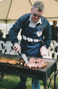
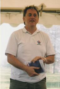
Photograph - Launch of History of a Street Precinct, 25 Sep
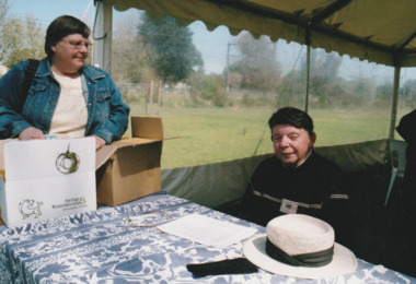
In 2005, members of the PMH&PS undertook a study of the residents of the houses in a Port Melbourne street precinct from the 1880s to 1960. The area is bounded by Evans Street, the E side of Bridge Street, S side of Williamstown Road, Farrell Street both the E & W sides plus the section of Ross Street between Farrell and Bridge and the part of Derham Street between Farrell and Bridge. The resulting map and an interactive CD won the Best Community Research, Registers & Records project at the 2007 Victorian Community History Awards. The project was launched on the railway reserve near the corner of Evans & Farrell streets. Jack BOLT is cooking with Ken TURNER in the background.Jack Bolt cooking sausages at the launch of the History of a Street Precinct25/9/05 Jack Bolt 11jack bolt, ken turner, history of a street precinct -
 Port Melbourne Historical & Preservation Society
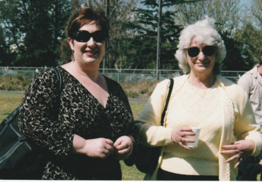
Photograph - Launch of History of a Street Precinct, 25 Sep
In 2005, members of the PMH&PS undertook a study of the residents of the houses in a Port Melbourne street precinct from the 1880s to 1960. The area is bounded by Evans Street, the E side of Bridge Street, S side of Williamstown Road, Farrell Street both the E & W sides plus the section of Ross Street between Farrell and Bridge and the part of Derham Street between Farrell and Bridge. The resulting map and an interactive CD won the Best Community Research, Registers & Records project at the 2007 Victorian Community History Awards. The project was launched on the railway reserve near the corner of Evans & Farrell streets. Liana ThOMPSON is with her mother , Fay BATES/ SHAW nee DEVINE.Liana Thompson & Fay Bates the launch of the History of a Street Precinct. 25/9/05 Liana Thompson, Fay Bates (previously Shaw nee Devine)liana thompson, fay bates, history of a street precinct -
 Port Melbourne Historical & Preservation Society
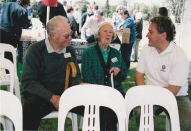
Photograph - Launch of History of a Street Precinct, 25 Sep
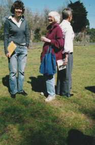
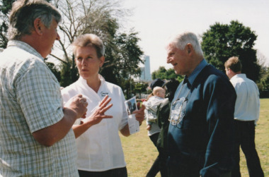
In 2005, members of the PMH&PS undertook a study of the residents of the houses in a Port Melbourne street precinct from the 1880s to 1960. The area is bounded by Evans Street, the E side of Bridge Street, S side of Williamstown Road, Farrell Street both the E & W sides plus the section of Ross Street between Farrell and Bridge and the part of Derham Street between Farrell and Bridge. The resulting map and an interactive CD won the Best Community Research, Registers & Records project at the 2007 Victorian Community History Awards. The project was launched on the railway reserve near the corner of Evans & Farrell streets. LL - R - unknown, Pat GRAINGER, Graham BRIDE.Pat GRAINGER, Graham BRIDE at the launch of the History of a Street Precinct project. 25/9/05 Not Known, Pat Grainger, Graham Bridepat grainger, graham bride, history of a street precinct -
 Port Melbourne Historical & Preservation Society
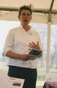
Photograph - Launch of History of a Street Precinct, 25 Sep
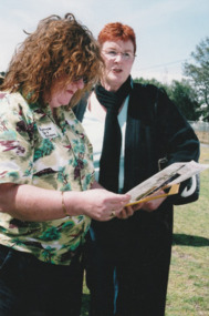
In 2005, members of the PMH&PS undertook a study of the residents of the houses in a Port Melbourne street precinct from the 1880s to 1960. The area is bounded by Evans Street, the E side of Bridge Street, S side of Williamstown Road, Farrell Street both the E & W sides plus the section of Ross Street between Farrell and Bridge and the part of Derham Street between Farrell and Bridge. The resulting map and an interactive CD won the Best Community Research, Registers & Records project at the 2007 Victorian Community History Awards. The project was launched on the railway reserve near the corner of Evans & Farrell streets. L- R - Natica SCHROEDER, Pat GRAINGER, Janet BOLITHO.Three members of the PMHPS the launch of the History of a Street Precinct25/9/05 Natica Schroeder, Pat Grainger, Janet Bolithohistory of a street precinct, pat grainger, natica schroeder, janet bolitho -
 Port Melbourne Historical & Preservation Society
Photograph - Launch of History of a Street Precinct, 25 Sep
In 2005, members of the PMH&PS undertook a study of the residents of the houses in a Port Melbourne street precinct from the 1880s to 1960. The area is bounded by Evans Street, the E side of Bridge Street, S side of Williamstown Road, Farrell Street both the E & W sides plus the section of Ross Street between Farrell and Bridge and the part of Derham Street between Farrell and Bridge. The resulting map and an interactive CD won the Best Community Research, Registers & Records project at the 2007 Victorian Community History Awards. The project was launched on the railway reserve near the corner of Evans & Farrell streets. L- R - Val POWER, Jim POWER.Two members of the PMHPS the launch of the History of a Street Precinct25/9/05 Val Power, Jim Powerhistory of a street precinct, val power, jim power -
 Port Melbourne Historical & Preservation Society
Photograph - Launch of History of a Street Precinct, 25 Sep
In 2005, members of the PMH&PS undertook a study of the residents of the houses in a Port Melbourne street precinct from the 1880s to 1960. The area is bounded by Evans Street, the E side of Bridge Street, S side of Williamstown Road, Farrell Street both the E & W sides plus the section of Ross Street between Farrell and Bridge and the part of Derham Street between Farrell and Bridge. The resulting map and an interactive CD won the Best Community Research, Registers & Records project at the 2007 Victorian Community History Awards. The project was launched on the railway reserve near the corner of Evans & Farrell streets. L- R - Robyn ?, Maralyn KOBELTMaralyn & Robin at the launch of the History of a Street Precinct25/9/05 Robyn ?, Maralyn Kobelthistory of a street precinct, maralyn kobelt -
 Port Melbourne Historical & Preservation Society
Photograph - Launch of History of a Street Precinct, 25 Sep
In 2005, members of the PMH&PS undertook a study of the residents of the houses in a Port Melbourne street precinct from the 1880s to 1960. The area is bounded by Evans Street, the E side of Bridge Street, S side of Williamstown Road, Farrell Street both the E & W sides plus the section of Ross Street between Farrell and Bridge and the part of Derham Street between Farrell and Bridge. The resulting map and an interactive CD won the Best Community Research, Registers & Records project at the 2007 Victorian Community History Awards. The project was launched on the railway reserve near the corner of Evans & Farrell streets. Darren Ray, Mayor of City of Port Phillip.City of Port Phillip mayor, Cr Darren Ray at the launch of the History of a Street Precinct25/9/05 Darren Ray Mayor CoPPhistory of a street precinct, darren ray -
 Port Melbourne Historical & Preservation Society
Photograph - Launch of History of a Street Precinct, 25 Sep
In 2005, members of the PMH&PS undertook a study of the residents of the houses in a Port Melbourne street precinct from the 1880s to 1960. The area is bounded by Evans Street, the E side of Bridge Street, S side of Williamstown Road, Farrell Street both the E & W sides plus the section of Ross Street between Farrell and Bridge and the part of Derham Street between Farrell and Bridge. The resulting map and an interactive CD won the Best Community Research, Registers & Records project at the 2007 Victorian Community History Awards. The project was launched on the railway reserve near the corner of Evans & Farrell streets. Janet BOLITHO, former mayor of City of Port Phillip.Former City of Port Phillip mayor, Janet Bolitho, at the launch of the History of a Street Precinct25/9/05 Janet Bolithohistory of a street precinct, janet bolitho -
 Port Melbourne Historical & Preservation Society
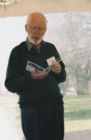
Photograph - Launch of History of a Street Precinct, 25 Sep
In 2005, members of the PMH&PS undertook a study of the residents of the houses in a Port Melbourne street precinct from the 1880s to 1960. The area is bounded by Evans Street, the E side of Bridge Street, S side of Williamstown Road, Farrell Street both the E & W sides plus the section of Ross Street between Farrell and Bridge and the part of Derham Street between Farrell and Bridge. The resulting map and an interactive CD won the Best Community Research, Registers & Records project at the 2007 Victorian Community History Awards. The project was launched on the railway reserve near the corner of Evans & Farrell streets. Co-author Graham BRIDE.Co-author, Graham Bride, at the launch of the History of a Street Precinct25/9/05 Graham Bridehistory of a street precinct, graham bride -
 Port Melbourne Historical & Preservation Society
Photograph - Launch of History of a Street Precinct, 25 Sep
In 2005, members of the PMH&PS undertook a study of the residents of the houses in a Port Melbourne street precinct from the 1880s to 1960. The area is bounded by Evans Street, the E side of Bridge Street, S side of Williamstown Road, Farrell Street both the E & W sides plus the section of Ross Street between Farrell and Bridge and the part of Derham Street between Farrell and Bridge. The resulting map and an interactive CD won the Best Community Research, Registers & Records project at the 2007 Victorian Community History Awards. The project was launched on the railway reserve near the corner of Evans & Farrell streets. L - R - Unknown, Norah HOWARD, Mayor Darren RAY.CoPP mayor and PMHPS members at the launch of the History of a Street Precinct25/9/05 Not known, Norah Howard, Darren Ray, Mayorhistory of a street precinct, darren ray, norma howard -
 Port Melbourne Historical & Preservation Society
Photograph - Launch of History of a Street Precinct, 25 Sep
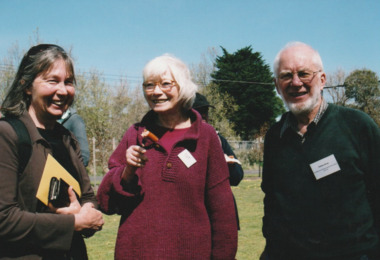
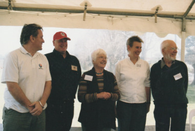
In 2005, members of the PMH&PS undertook a study of the residents of the houses in a Port Melbourne street precinct from the 1880s to 1960. The area is bounded by Evans Street, the E side of Bridge Street, S side of Williamstown Road, Farrell Street both the E & W sides plus the section of Ross Street between Farrell and Bridge and the part of Derham Street between Farrell and Bridge. The resulting map and an interactive CD won the Best Community Research, Registers & Records project at the 2007 Victorian Community History Awards. The project was launched on the railway reserve near the corner of Evans & Farrell streets. l - R - Mayor Darren RAY, David THOMPSON, Margaret BRIDE, Janet BOLITHO, Graham BRIDE.CoPP mayor and PMHPS members involved in the production at the launch of the History of a Street Precinct25/9/05 Mayor, David Thompson, Margaret Bride, Janet Bolitho, Graham Bridehistory of a street precinct, darren ray, graham bride, margaret bride, janet bolitho, david thompson -
 Port Melbourne Historical & Preservation Society
Photograph - Launch of History of a Street Precinct, 25 Sep
In 2005, members of the PMH&PS undertook a study of the residents of the houses in a Port Melbourne street precinct from the 1880s to 1960. The area is bounded by Evans Street, the E side of Bridge Street, S side of Williamstown Road, Farrell Street both the E & W sides plus the section of Ross Street between Farrell and Bridge and the part of Derham Street between Farrell and Bridge. The resulting map and an interactive CD won the Best Community Research, Registers & Records project at the 2007 Victorian Community History Awards. The project was launched on the railway reserve near the corner of Evans & Farrell streets. L - R - Unknown, Janet BOLITHO, Glen STUART.CoPP mayor and PMHPS members at the launch of the History of a Street Precinct25/9/05 Not known, Janet Bolitho, Glen Stuarthistory of a street precinct, janet bolitho, glen stuart -
 Ithacan Historical Society
Photograph, Bill Florence arriving in Australia, 1922
This photograph was taken when Bill Florence (Vasilis Florias) arrived in Melbourne in 1922. Many migrants on their arrival in Australia were photographed within this backdrop. Copies of these photos were often sent to their families back in their homeland.A sepia photograph of a portrait view of a man framed within a map of Australia with the words 'Welcome To' across the top of the map. Around the map are sketches of Australian bush scenes, animals and the sea.immigration -
Port Melbourne Historical & Preservation Society
Map - Melbourne and suburbs, Department of Lands and Survey, 1 May 1934
Large printed map of Melbourne and suburbs 1936 showing historic sightsmelbourne, south melbourne, transport - tramways, transport - railways -
Port Melbourne Historical & Preservation Society
Plan - Proposed Lorimer Street realignment, City of Port Melbourne, 28 Oct 1938
Printed map of City of Port Melbourne with proposed Lorimer Street realignment marked in red and blue.Pencilled lower right: Proposed realignment Lorimer St Also 'Request by Council under Sec 523 L. Getch' : (Getel?)engineering - roads streets lanes and footpaths, l getel, l getch