Showing 4076 items matching " surveys"
-
 Villa Alba Museum
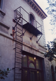
Photograph - Exterior wall, entrance to vestibule and fire escape, c.1987
Built for William and Anna-Maria Greenlaw in the early 1880s, and with interiors decorated by the Paterson Bros, Villa Alba remained in private ownership until 1949. From 1950, the house was owned by a number of institutions. By 1984, the Villa Alba Preservation Society had been formed, and three years later, the Mount Royal Hospital granted a 25-year lease to Kew Council. In 2004, the title to Villa Alba was passed by the Victorian Government to The Villa Alba Museum Incorporated. The Museum, at 44 Walmer Street, Kew, is now a cultural institution committed to the collection, study and display of 19th century interior decorative finishes, and the components of 19th and 20th century interior decoration. This is one of a number of historically and aesthetically significant photos of the interiors and exterior of Villa Alba when it was still owned by the Mount Royal Hospital, showing twentieth century accretions and deterioration of the historic fabric of the building. This was a benchmark survey against which future conservation and restoration activities can be measured.In December 1987, Mockridge Stahle & Mitchell Pty Ltd Architects prepared ‘Villa Alba Survey: A Report on the fabric for Mount Royal Hospital’ of which this photograph is a part. The photo is of the Exterior (east) wall (east), the entrance to vestibule and an external fire escape. [The fire escape was later removed.]villa alba museum, conservation photographs, victorian architecture, fire escapes -
 Glenelg Shire Council Cultural Collection
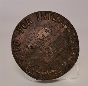
Functional object - Survey Mark
Brass mushroom shaped object. The stalk end has a split in the bottom like an old peg. The top of the marker has 50 pound penalty for interference on it. It looks as though several words have been chipped off or out from the middle of the top. Look to be ' Survey Mark'Penalty 50 for interferencesurvey, surveying tool, land, marker -
 Bendigo Historical Society Inc.
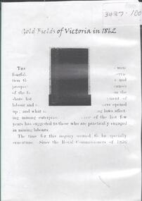
Archive - GOLDFIELDS OF VICTORIA IN 1862, 1862
DVD. Goldfields of Victoria in 1862. A comprehensive survey of Victoria's goldfields in 1862 in response to two questions " then occupying a considerable share of public attention in the colony. The first was whether the older fields were showing signs of exhaustion; and he second was the social condition of the miners engaged upon them. -
 University of Melbourne, Burnley Campus Archives
Plan, Circus Site, c. 1990
(1) Copy of Plan: City of Richmond City Engineers Department Circus Site: includes Descriptions of Site Preparation, Plant List and Plant Order List. (2) On tracing paper: Plant Plan. (3) On tracing paper: "Yarra Vegetation Survey - Site 3," Plant Plan(1) Handwritten on reverse, "Richmond Council - Yarra Blvd to Bridge Road."circus, survey, richmond, vegetation survey, colin mock, yarra river -
 City of Greater Bendigo - Civic Collection
Instrument - Gunter Chain, not known
Gunter's chain (also known as Gunter’s measurement) is a distance measuring device used for surveying. It was designed and introduced in 1620 by English clergyman and mathematician Edmund Gunter (1581–1626). It enabled plots of land to be accurately surveyed and plotted, for legal and commercial purposes. The provenance of this particular Gunter Chain is unknown but it is believed to be used either by the City of Bendigo / Sandhurst or the Lands Department locally when measuring and laying out plots and streets locally. A 66-foot (20.1 m) chain divided into 100 links, marked off into groups of 10 by brass rings or tags. Each link is 7.92 inches (201 mm) long. A quarter chain, or 25 links, measures 16 feet 6 inches (5.03 m) also called a a rod (or pole) measure. Ten chains measure a furlong and 80 chains measure a statute mile. city of greater bendigo surveying -
 Bendigo Military Museum
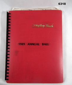
Administrative record - Army Survey Regiment Officers Mess Ball 1989, Army Survey Regiment, 25 Feb 1989
The Army Survey Regiment held Annual Balls at Fortuna Villa. This folder contains the documentation for the Logistics and activities associated with the planning and running of the Ball in 1989.A4 Plastic bound Red Display Folder containing documentation for the 1989 Annual Ball, Letters, signals and photosroyal australian survey corps, rasvy, fortuna, army survey regiment, army svy regt, asr -
 Bendigo Military Museum
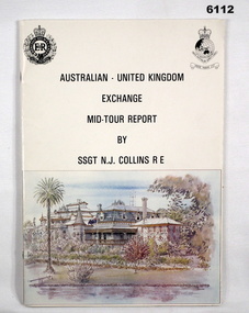
administrative record - Australian - United Kingdom Exchange Mid Tour Report by SSGT NJ Collins RE 1987, SSGT N.J. Collins RE, 29. 03.1987
The document is the Mid Tour Report by SSGT N.J. Collins RE, a British Army Senior NCO on a two-year exchange to the Army Survey Regiment. A4 size, Stapled, Front cover has a reproduction of a painting of Fortuna Villa in bottom half. Back cover has a difficult to see street scene of Pall Mall, Bendigo with a paragraph describing Bendigo's history superimposed. 19 Pages. The actual Report is contained on Pages 1-16. Annex A is 2 x pages plus a contents page.Green Hi-Light on parts of pages 10 and 11.royal australian survey corps, rasvy, fortuna, army survey regiment, army svy regt, asr -
 Bendigo Military Museum
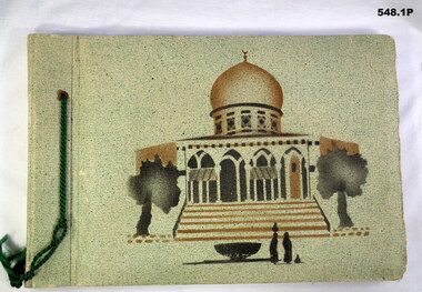
Album - PHOTOGRAPH ALBUM, WWII
The album collection belonged to Jack Smethurst VX28896 Australian Army Survey Regiment (Royal Australian Artillery). Refer 549.4, 550.2, 557, 558.6.548.1P. Green front, picture of mosque, photos of Syria. Green cord on side. MIxture of B&W photos and small postcards. Four loose B&W photos inside front cover. 548.2P. Black cover, silver inlay of David's Tower. Brown cord on spine. Tourist and Australian Army B&W photos. Six loose B&W photos between first and second pages. 548.3P. Black cover, silver inlay of Rachael's Tomb. Brown cord on spine. Two loose photos on back pages. Tourist and Army photos of Libya, Palestine and Syria.books-albums, photography-photographs, middle east, military history, royal australian artillery -
 Bendigo Military Museum
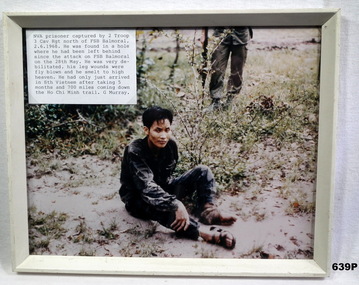
Photograph - PHOTOGRAPH VIETNAM, FRAMED, 2/6/68
Photo in collection re Geoff Murray No 3411521, Vietnam 3 Cav Regt 27.11.67 to 22.10.68, Survey Corp 15.10.69 to 15.10.70. Refer 638P.Colour photo, Vietnam showing a captured NVA soldier sitting on the ground. Attached label gives details of time and place. Frame is cream painted wood.vietnam, viet cong, fsb balmoral -
 Bendigo Military Museum
Souvenir - DOCUMENTS 3 CAV REGT, 14.5.1986
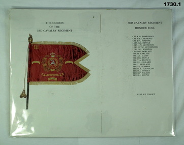
Items relate to Geoff Murray No 3411521, Vietnam 3 Cav Regt 27.11.67 to 22.10.68, Survey Corp 15.10.69 to 15.10.70. Refer Cat No 638P.1) Document showing the Guidion of the 3rd Cavalry Regiment and that unit's honour roll Vietnam. .2) Document relating to the presentation of the 3rd/4th Cavalry Regiment's Guidion at Ennogerra Barracks QLD by the Duke of Edinburgh Prince Phillip. .2) "Wed 14 May 1986"documents, military history-army, 3 cav regt, guidions -
Creswick Campus Historical Collection - University of Melbourne
Maps, 1967 - 1972
Maps of various subjects: Gunbower Island 1972. Barmah Forest 1967. Survey maps from aerial photography 1971 _Narnargoon.Tonimbuk. Gilwell & Beenak.Maps -
![Book - Article, Fiona Weaver, Lower Plenty River Archaeological Survey by Fiona Weaver [excerpt], 1991](/media/collectors/62fc2e8d3b4c83fe7f279a1c/items/6450d73a49371722cf4f2ee8/item-media/6450d9b949371722cf4f5830/item-fit-380x285.jpg) Heidelberg Golf Club
Heidelberg Golf ClubBook - Article, Fiona Weaver, Lower Plenty River Archaeological Survey by Fiona Weaver [excerpt], 1991
Excerpt from Lower Plenty River Archaeological Survey by Fiona Weaver. Section 5 on Aboriginal archaeological sites in the Lower Plenty River area.A survey of First Nations sites in the Lower Plenty River area.Copy of part of book.lower plenty river, aboriginal sites -
 Bendigo Military Museum
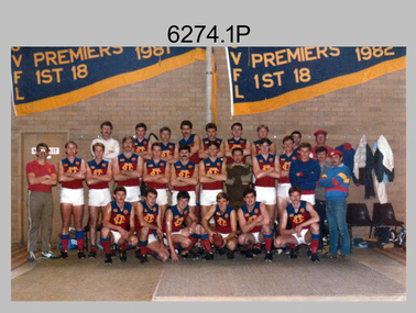
Photograph - Army Survey Regiment’s Fortuna Lions Football Club Grand Finals, Seymour, Victoria, 1983
This is a set of seven colour and black and white photographs of Army Survey Regiment’s Australian Rules football team – the Fortuna Lions aka “Fortuna Fumblers”, taken at Seymour and Bendigo Victoria in 1983. The Fortuna Lions competed in the Puckapunyal Area Football Association for several years from 1978 to 1984 and in 1983, fielded a great team it managed to reach the Grand Final. Held at the neutral ground at Kings Park, Seymour, the match was an incredibly exciting and bruising contest played in damp conditions and ended in a draw. Dave Lawler’s spectacular mark was a highlight. Due to heavy rain during the following week, the Grand Final replay was held the following week in even heavier conditions. The Fortuna Lions prevailed in the replay with an emphatic victory. The team’s leaders were Eddie Jacobs (coach), Rhys De Laine (captain), Greg Else (vice-captain), and Ken Slater (manager). Refer to items 6244.27P (black & white) and 6245.26P (colour) for other photographs taken at the two grand finals.This is a set of seven photographs of Army Survey Regiment’s Australian Rules football team – the Fortuna Lions aka “Fortuna Fumblers”, taken at Seymour Victoria in 1983. The photographs were printed on photographic paper and are part of the Army Survey Regiment’s Collection. The photographs were scanned at 300 dpi. .1) - Photo, colour. 1983. Fortuna Lions Football Team - Back row L to R: Don Mawson, Stuart Ridge, Alan Staley, Doug Home, Dave Lawler, Greg Byers, Glenn Cannon, Keith Quinton, Mick ‘Buddha’ Ellis. Middle row L to R: Brian Paul, Dennis Learmonth, Greg Higgins, Jim Ash, Larry Thompson, Rhys De Laine, Eddy Jacobs, Ken Slater, Bob Thrower, Andy Godden, Nick Van Dalen, Peter Colwell, Warren ‘Wah’ Hall. Front row L to R: Mick Hogan, Rod Skidmore, Terry McIntyre, Greg Else, Terry Winzar, Peter Jones. .2) - Photo, colour. 1983. Fortuna Lions Football Team Grand Final Banner. .3) - Photo, colour. 1983. L to R: Kristin (Isaac) Skidmore, Santina (Argetto) Straube, Stuart Ridge, Nick Van Dalen, Larry Thompson, Jim Ash, Carmel (Butler) Fauth, Gayle Humphrey. .4) - Photo, black and white. 1983. Jim Ash in celebration. .5) - Photo, black and white. 1983. L to R: unidentified, Brian Fauth, Glenn Cannon. .6) - Photo, black and white. 1983. L to R: Doug Home, back of Warren ‘Wah’ Hall, Terry Winzar with premiership cup. .7) - Photo, black and white. 1983. Larry Thompson with premiership cup..1P to .7P – there are no annotations.royal australian survey corps, rasvy, army survey regiment, army svy regt, fortuna, asr -
 Bendigo Military Museum
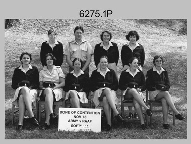
Photograph - Bones Day - Army Survey Regiment Versus RAAF School of Radio. Fortuna, Bendigo, 1978
These eight photographs were taken at Bones Day, an annual sports competition between the Army Survey Regiment and the RAAF School of Radio at Bendigo in November 1978. The two units took turns each year to host the event. The day competition usually comprised basketball, cross country, golf, sailing, squash, softball, tennis, touch football, rifle shooting, tug-of-war and volleyball. The “big bone” trophy comprising a large bone from a beast housed inside a wooden framed glass case, was awarded to the winner of the day competition. The evening competition often included darts, carpet bowls, hookey, quoits and billiards/snooker. The “little bone” (a mounted chicken bone) was the consolation trophy awarded to the winner of the evening competition. The 3-hour bus trip for the visiting unit on their return was typically very raucous. The history of the Bones Day competition is best described in the booklet titled - Bones of Contention Souvenir Program. 1965. Refer to Item 6267. See item 9001.31P for more photographs taken on this occasion.These eight photographs were taken at Bones Day, an annual sports competition between the Army Survey Regiment and the RAAF School of Radio at Bendigo in November 1978. The photographs were printed on photographic paper and are part of the Army Survey Regiment’s Collection. The photographs were scanned at 300 dpi. .1) - Photo, black & white, 1978, Softball Team Back Row L to R: Janet (Chopping) Justin, John Ashby, Scheryal Delforce, Tracey (Beckwith) Phillips. Front Row L to R: Zoe (Lisiewich) Ames, Di Chalmers, unidentified, Le-Anne (Smallshaw) Shirley, Lorraine (Daly) Talbot-Smith, Lynn Johnson. .2) - Photo, black & white, 1978, Tennis Team Back Row L to R: Mick Flynn, Chris Carter, Ken Delmenico. Front Row L to R: unidentified (x3), Adrian Rynberk. .3) - Photo, black & white, 1978, Golf Team Back Row L to R: George Austen, unidentified, Roger Rees. Front Row L to R: Peter Imeson, Greg Gilbert, unidentified officer, Paul Richards. .4) - Photo, black & white, 1978, Basketball action: Gill Park – No. 8 .5) - Photo, black & white, 1978, evening events: L to R: Garry Hudson, unidentified RAAF airwoman. .6) - Photo, black & white, 1978, evening events: L to R: Gary Warnest, Wayne Rothwell. .7) - Photo, black & white, 1978, evening events: L to R: Mick ‘Buddha’ Ellis, unidentified RAAF airwoman. .8) - Photo, black & white, 1978, evening events: L to R: Mick ‘Buddha’ Ellis, unidentified, Ian Belmont, Ken Slater. .1P to .8P – No personnel are annotated.royal australian survey corps, army svy regt, rasvy, army survey regiment, fortuna, asr, raaf school of radio, bones day -
 Bendigo Military Museum
Map - MAPS, FRANCE WW1, 1915 - 1917
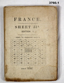
(.1) Areas covered by this map, Somain to Valenciennes, Ramillies to Beaudignies. (.2) Areas covered on this map, Bellicourt to Tupigny, St Quentin to Guise. (.3) Areas covered on this map, Heslin to lens, Domart to Baupaume. (.4) Areas covered on this map, Dieppe to Le Quesnoy, Monville to Bonniers. (.5) Same as (.2) Items relate to William Alexander No 502 AIF. Refer 3746.3 for his service details.(.1) Map, France, sheet 51A, Edition 1, scale 1:40,000, Ordnance survey 1916, gauze lined, rear has glossary of terms French to English. (.2) Map, France, sheet 62B, first edition, scale 1:40,000, Ordnance survey December 1917, gauze lined, rear has glossary of terms French to English. (.3) Map France, Lens 11, scale 1:100,000, OSO 1915, gauze lined. (.4) map, France, Dieppe 16, scale 1:100,000, general staff No 2364, War Office 19– gauze lined. (.5) Map, France (same as (.2)(.2 & .5) On rear hand written “124 A.L.T.M.B P179/5maps, france -
 Ringwood and District Historical Society
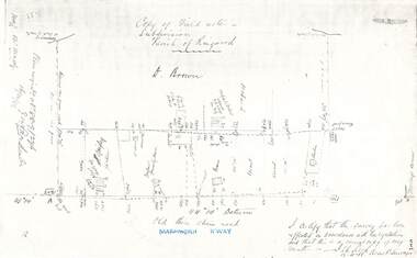
Document - Copy of Lands Department Field Notes - Parish of Ringwood, Victoria, Field Notes 88-9/276 - Part of O.P. R72C surveyed 12.10.1888
Foolscap size photocopy of survey map with handwritten notations. References include - Commencing at bank of creek, Bearing over fence read 134"12', post and rail fence, old round post, Quigley, WB house iron roof, paling & shingle roof, garden, Forshaw formerly Hoare, D Brown, stable & shed, slats & palings, orchard, Occupied by Forshaw, 4 rooms WB Cottage iron roof, Sherbin, Old three chain road, Maroondah Highway, Molloy's corner, I certify that this survey has been effected in accordance with the regulations and that this is a correct copy of my results (signed) - Reed, Assistant Surveyor, 12.10.88. -
 Bendigo Military Museum
Photograph - 4th Field Survey Squadron – Operation NERVOSE 85 Reconnaissance, Northern Territory, 1985
This is a set of 13 photographs taken in 1985* during reconnaissance of locations in regions of the Northern Territory. Later that year, Operation NERVOSE 85 was mounted by 4 Fd Svy Sqn in the EAST ARNHEM, VICTORIA RIVER DOWNS AND DALY WATERS areas of the Northern Territory from 26 May to 18 Sep 85. The aim of Operation NERVOSE 85 was to finalise the horizontal and vertical control for mapping at a scale of 1:50,000, to field check 40x 1:50,000 preliminary maps and to obtain mapping photography in support of the RAAF TINDAL redevelopment project. *Note –These photos were most likely taken in 1985, contrary to the ‘1987’ date annotated on the negative sleeves. The Op NERVOSE 85 Project Report available on RASVY’s web site lists a nominal roll of personnel. Photos of 4 Fd Svy Sqn taken in 1985 and 1987 provide names of posted personnel. Several personnel identified in these photos were posted to 4 Fd Svy Sqn in 1985, not in 1987.This is a set of 13 photographs taken during 4th Field Survey Squadron’s reconnaissance of Operation NERVOSE 85 locations in the Northern Territory in 1985. The colour photographs are on 35mm negative film and are part of the Army Survey Regiment’s Collection. The photographs were scanned at 96 dpi. .1) to .4) - Photo, colour, 1985. Unknown location in the Northern Territory. .5) - Photo, colour, 1985. Unidentified personnel in the back of a police vehicle. .6P to .12) - Photo, colour, 1985. Unknown location in the Northern Territory. .13) - Photo, colour, 1985. L to R: Possibly MAJ A. Vickers RE - UK Exchange Officer from Army Svy Regt, unidentified officer. .1P to .13P – There are no personnel identified. ‘1987 OP NERVOSE – RECON PHOTOG.’ annotated on negative sleeve.royal australian survey corps, rasvy, 4 fd svy sqn, op nervose 85 -
 Bendigo Military Museum
Photograph - Army Survey Regiment - Defence Force Service Medal Presentations, Fortuna Villa, Bendigo, 1979
This is a set of nine photographs of Defence Force Service Medal presentations by the Chief of the General Staff (CGS) Lieutenant General Sir Donald Dunstan AC, KBE, CB; at the Army Survey Regiment, Fortuna, Bendigo on the 5th of June 1979. The photos were taken next to the flagpole in Fortuna Villa’s front garden. Upon retirement from the Army in 1982, Lieutenant General Sir Donald Dunstan AC, KBE, CB; was appointed to the position of Governor of South Australia from 1982 to 1991. On this occasion the CGS presented the Defence Force Service Medal to WO2 Alex Cairney, WO1 Bob Mason and WO2 Ken Slater for 15 years of efficient remunerated service in the Australian Army. It is likely the unidentified UK Exchange senior NCO was the recipient of the UK Army’s equivalent service medal. Other key staff appearing in these photos are LTCOL Bob Skitch was the CO of the Army Svy Rgt from 1976 to 1980 and WO1 Aub Harvey, who was RSM from 1976 to 1982. MAJ Don Swiney MBE was later promoted to LTCOL and was CO of the Army Svy Rgt from 1985 to 1987. He was subsequently promoted to Colonel and was Director of the Royal Australian Survey Corp from November 1988 to January 1991, and the honorary position as Colonel Commandant from January 1993 to January 1996. See item 6034.14P for photos of the CGS’s tour through the production areas of the Army Svy Rgt.This is a set of nine photographs of Defence Force Service Medal presentations by the Chief of the General Staff (CGS) at the Army Survey Regiment, Fortuna, Bendigo on the 5th of June 1979. The photographs were printed on photographic paper and are part of the Army Survey Regiment’s Collection. They were scanned at 300 dpi. .1) - Photo, black and white, 1979. L to R: RSM WO1 Aub Harvey, CAPT Don Maskew, CGS LTGEN General Sir Donald Dunstan AC, KBE, CB; MAJ Don Swiney MBE, CO LTCOL Bob Skitch. .2) - Photo, black and white, 1979. Foreground L to R: CO LTCOL Bob Skitch, MAJ Don Swiney MBE, CGS LTGEN General Sir Donald Dunstan AC, KBE, CB; CAPT Don Maskew. Background L to R: WO2 Ken Slater, WO2 Alex Cairney, WO1 Bob Mason, unidentified UK Exchange senior NCO. .3) - Photo, black and white, 1979. L to R: WO2 Ken Slater, WO2 Alex Cairney, WO1 Bob Mason, unidentified UK Exchange senior NCO. .4) & .5) - Photo, black and white, 1979. L to R: WO2 Ken Slater, CGS LTGEN General Sir Donald Dunstan AC, KBE, CB; CAPT Don Maskew, MAJ Don Swiney MBE, CO LTCOL Bob Skitch. .6) - Photo, black and white, 1979. L to R: RSM WO1 Aub Harvey, unidentified UK Exchange senior NCO, , CGS LTGEN General Sir Donald Dunstan AC, KBE, CB; MAJ Don Swiney MBE, CO LTCOL Bob Skitch, unidentified aide de camp officer. .7) - Photo, black and white, 1979. L to R: RSM WO1 Aub Harvey, WO2 Alex Cairney, CAPT Don Maskew, LTGEN General Sir Donald Dunstan AC, KBE, CB; MAJ Don Swiney MBE, CO LTCOL Bob Skitch, unidentified aide de camp officer, unidentified photographer. .8) - Photo, black and white, 1979. L to R: RSM WO1 Aub Harvey, CAPT Don Maskew, WO1 Bob Mason, LTGEN General Sir Donald Dunstan AC, KBE, CB; MAJ Don Swiney MBE, CO LTCOL Bob Skitch, unidentified aide de camp officer, unidentified RAAF officer, MAJ Peter Eddy. .9) - Photo, black and white, 1979. L to R: WO1 Bob Mason, WO2 Ken Slater, RSM WO1 Aub Harvey, WO2 Alex Cairney, unidentified UK Exchange senior NCO..1P to .14P – no annotationsroyal australian survey corps, rasvy, army survey regiment, army svy regt, fortuna, asr -
Federation University Historical Collection
Booklet, J.H. Pollitt, An Historical Record of Melton, c1961
Melton is a town in Victoria.Orange soft covered booklet of 64 pages. Includes sections on Aborigines, John Bull, exploration, survey, early settler, graves, Melton Roads Board, cemetery, common school, churches, agricultural society, rail, Melton weir, index of students enrolled at the Melton Common School in 1864.william dredge darke, samuel staughton, simon straughton, thomas henry pyke, djerriwarrh, charles williams, richard manning, william oldershaw, william yuille, benjamin porter, john ferris, captain moonlight, viaduct, pennyroyal creek, thomas pyke, toolern toolern creek, melton, keilor station, melton weir, melton common school, john bull, melton coursing cup, melton agricultural society -
 Federation University Historical Collection
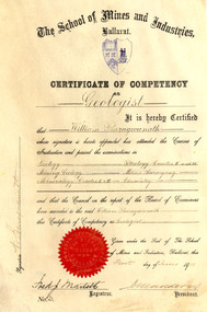
Certificate, Ballarat School of Mines Competency as a Geologist Certificate, o1/06/1911
William Baragwanath became Victorian Government Geologist. Cream coloured vellum certificate with blues Ballarat School of Mines Crest and red seal. It is a Ballarat School of Mines Certificate of Competency as a Geologist made out to William Baragwanath in 1911. The Certificate of Competency included passing examinations in Geology, Mining geology, Mineralogy, Petrology, Mine Surveying and Chemistry.Signed on left 'W. Baragwanath'ballarat school of mines, geology, petrology, mineralogy, surveying, chemistry, baragwanath, martell, frederick martell, maddern, geology alumni, william baragwanath -
Bendigo Historical Society Inc.
Map - PANNOOBAMAWM : COUNTY OF BENDIGO, 7-9-15
Map. Pannoobamawm, County of Bendigo, Terrick Terrick East, Wanurp, Pannoomilloo, Bamawm,Turrumberry. By authority Albert J. Mullett, Government Printer, Melbourne. Photographed at the Deptartment of Lands and Survey, Melbourne. By W.J. Butson 7-9-15. Price 1/-. (number 81 in map cupboard 1)W.J. Butson, Government Printer, Melbourne.map, bendigo, pannoobamawm -
Bendigo Historical Society Inc.
Map - JANIEMBER WEST : COUNTY OF BENDIGO, September 1955
Map. Janiember West, County of Bendigo. Loddon River, Janiember East, Powlett, Kinypanial, Jarklan. Welsh's Lagoon. By authority W.M. Houston, Government Printer, Melbourne. Drawn and reproduced at the Department of Lands and Survey, Melbourne, September 1955, Price 5/-. (number 66 in map cupboard 1)W.M. Houston, Government Printer, Melbourne.map, bendigo, janiember west -
Bendigo Historical Society Inc.
Map - KAMAROOKA : COUNTY OF BENDIGO, 29-8-21
Map. Kamarooka, County of Bendigo, Milloo, Warragamba, Minto, Whirrakee, Tandarra, Piccaninny Creek, Dingee. By authority A.J. Mullett, Govt. Printer. Photo-Lithographed at the Department of Lands and Survey, Melbourne by W.J. Butson 29-8-21. Price 1/-. (number 63 in map cupboard 1)A.J. Mullett, Govt.Printermap, bendigo, kamarooka -
 Bendigo Historical Society Inc.
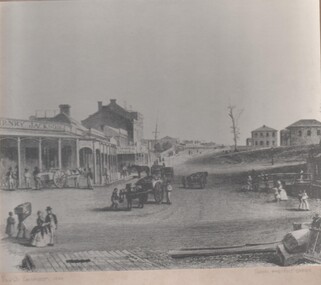
Photograph - GOLDEN SQUARE HIGH SCHOOL COLLECTION: PHOTOGRAPH VIEW STREET SANDHURST
Black and white photograph of an early painting showing View Street Sandhurst in 1859 with Survey and Post Office. Several people walking around , four horse drawn carriages, on the left Henry Jackson store and a row of houses and shops under a portico on the right two double story houses .bendigo, streetscape, view street -
 Bendigo Historical Society Inc.
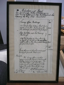
Document - VALUATION AND REPORT ON LAND AND PUBLIC BUILDINGS, 1888
Framed document, valuation and report on land and public buildings vis old survey office and Post Office and sub Treasury in View Street Sandhurst, hand written in black ink and signed N P Simpson Feby 22nd 1888. Under glass in a thin black wooden frame.document, certificate, public buildings -
Bendigo Historical Society Inc.
Map - TARNAGULLA : COUNTY OF BENDIGO, 1959
Map. Tarnagulla, County of Bendigo, Sheet 3, Kingower, Glenalbyn, Inglewood, Loddon River, Derby, Gladstone. Drawn and reproduced at the Department of Lands and Survey, Melbourne, 1959. Price 5/- per sheet. By authority A.C. Brooks, Government Printer, Melbourne. (number 35 in map cupboard 1)A.C. Brooks Government Printer, Melbourne.map, bendigo, tarnagulla -
Bendigo Historical Society Inc.
Map - CORNELLA : COUNTY OF BENDIGO, 13-4-32
Map. Cornella, County of Bendigo, County of Rodney, Colbinabbin, Gobarup, Redcastle, Toolleen, Kangaroo Creek, Cornella Creek. By authority H.J. Green, Govt. Printer. Photo-Lithographed at the Department of Lands and Survey, Melbourne. 13-4-32. Price 2/-. (number 123 in map cupboard 1)H.J. Green, Govt.Printermap, bendigo, cornella -
Bendigo Historical Society Inc.
Map - BRIDGEWATER : COUNTY OF BENDIGO, 6-10-27
Map. Bridgewater, County of Bendigo, Inglewood, Salisbury, Derby, Leichardt, Yarraberb, Yarrayne, Bullock Creek, Loddon River, Sandhurst and Inglewood Railway. Photo-Lithographed at the Department of Lands and Survey Melbourne by W.J. Butson, 6-10-27. Price 1/-. (number 53 in map cupboard 1)W.J. Butsonmap, bendigo, bridgewater -
Bendigo Historical Society Inc.
Map - BAMAWM : COUNTY OF BENDIGO, November 1954
Map. Bamawm, County of Bendigo. Sheet 2, Pannoobamawm, Diggorra. Elmore to Cohuna Railway Line. Township of Lockington. By authority W.M. Houston, Government Printer.Drawn and reproduced at the Department of Lands and Survey, Melbourne. November 1954. Price 5/- per sheet. (number 52 in map cupboard 1)W.M. Houston, Government Printermap, bendigo, bamawm -
Bendigo Historical Society Inc.
Map - BAGSHOT, COUNTY 0F BENDIGO, 24-5-21
Map, Bagshot, County of Bendigo,Whirrakee, Egerton, Goornong, Ellesmere, Wellsford, Huntly, Reedy Creek, Sandy Creek.Photo-Lithographed at the Dept. of Lands and Survey, Melbourne by W.J.Butson, 24-5-21. Price 1/-.. By authority A.J.Mullett, Govt. Printer,Melbourne. (number 49 in map cupboard 1)A.J.Mullett, Government Printer, Melbourne.map, bendigo, bagshot