Showing 2901 items matching "2008"
-
 Eltham District Historical Society Inc
Photograph - Digital Photograph, Marguerite Marshall, Eltham Lower Park, 20 April 2008
Originally a race course, the park has brought the community together with a variety of activities. Published: Nillumbik Now and Then / Marguerite Marshall 2008; photographs Alan King with Marguerite Marshall.; p45 Once used for horse racing, which attracted visitors from Melbourne, the Eltham Lower Park has brought the community together with a wide range of activities. Horse riding is now enjoyed as a recreation in the park as are other sports. The park also includes the Diamond Valley Railway miniature trains and a sanctuary for the rare and vulnerable Eltham Copper Butterfly. Eltham Lower Park, with other parks, forms an almost continuous green band from Eltham’s centre, along the Diamond Creek to the Yarra River.1 Before European settlement the Wurundjeri people met on this land, particularly at the junction of the Diamond Creek with the Yarra River, which they called Birr-arung. This is commemorated by the sculpture, Not just a Pretty Place by Aleks Danko, winner of the 2000 Nillumbik Art in Public Places Award. The first European to settle here was probably Henry Foley, who in 1841 used it as part of his pastoral run. Foley sold his leasehold to Joseph Wilson in 1845, who soon after sold it to Frederick Falkiner. During the 1840s the future park was part of a government square mile (2.6 sqkm) reserve, north of the Yarra, within the Parish of Nillumbik, later named Eltham. Soon the land was used for horse racing after nearby residents cleared ten acres (4ha) in the early 1850s. A three-quarter of a mile (1.2km) race secured the winner the £10 Publican’s Prize. In response to popular demand, the newly formed Eltham District Road Board petitioned the Surveyor General of the Colony of Victoria, in 1856, for 36 acres (14.6ha) of crown land for a racecourse and recreation. By 1858 the Eltham races had become an institution. ‘Many skirmishes occurred and the way home was paved with temptation, with sly-grog for sale.3 In the early 1870s, two jockeys were sons of the police officer in charge of the Eltham Police Station, Miles S Lyons. Another ten acres (4ha) was added to the area in 1866 and 12 acres (4.8ha) – Hohnes Hill – in 1870. In 1866, two acres (0.8ha) on the creek banks became an animal pound with William Walsh the pound keeper in 1870, but this was later incorporated into the park. By 1877 the area was called a public park but horse racing and training continued into the 1920s. In the mid-1900s trotters were trained on a circuit road. In 1953 the Eltham Pony Club was established and used a cross-country course on Hohnes Hill. From the mid 1950s the club held the Eltham Easter Fair at the park, later to include a procession along Main Road from the town centre to the park. The park also attracted picnic parties and campers from the inner suburbs as did Wingrove Park, and businesses catering for visitors, sprang up on the opposite side of Main Road. Bus-loads of school children visited the park for Gould League bird days in the 1960s. In 1979 the Eltham Shire Council bought Lenister Farm, linking the park with the Yarra River. The Lenister Farm wetland includes a bird hide, viewing platform and interpretive signs.5 Pioneer Henry Stooke, later Road Board chairman, bought the 11 acres (4.5ha) - later to become Lenister Farm - from the Crown in 1862. Stooke never lived on this site and the two houses at Lenister Farm were built in the 20th century. Since its formation in 1871, the Council has controlled this crown land, which it named Eltham Park. But in the 1920s Eltham Council bought land near the town centre for a park, which it named Eltham Central Park. To avoid confusion the Council renamed Eltham Park, Eltham Lower Park. Since 2004 the Yarra footbridge has linked the park with the Yarra Valley Metropolitan Park and the Main Yarra Trail.This collection of almost 130 photos about places and people within the Shire of Nillumbik, an urban and rural municipality in Melbourne's north, contributes to an understanding of the history of the Shire. Published in 2008 immediately prior to the Black Saturday bushfires of February 7, 2009, it documents sites that were impacted, and in some cases destroyed by the fires. It includes photographs taken especially for the publication, creating a unique time capsule representing the Shire in the early 21st century. It remains the most recent comprehenesive publication devoted to the Shire's history connecting local residents to the past. nillumbik now and then (marshall-king) collection, eltham lower park, eltham park -
 Eltham District Historical Society Inc
Photograph - Digital Photograph, Alan King, Panton Hill Hotel, 27 March 2008
Today’s Panton Hill Hotel was built around 1920. Published: Nillumbik Now and Then / Marguerite Marshall 2008; photographs Alan King with Marguerite Marshall.; p61 Panton Hill was originally known as Kingstown, and consisted of only one hotel when the Orams Reef was discovered in 1859. Kingstown was a quartz mining centre and many old mine shafts remain in the area. Orams Reef was one of the first reefs with a rich find of gold in the area. The Hotel Francais, which had been operating in 1861, was well situated on the way to Queenstown (later St Andrews). So was Herr Hirt’s Hotel and store at Smiths Gully. The Kingstown hotel, known as the Frenchman’s and in 1864 as the Hotel de France, was run by a Monsieur Emile Hude and his wife Jeanne, and known for its good food. They hosted social events, business conventions and debates, attracting patrons from as far as Melbourne. The hotel’s name was changed to Panton Hill Hotel in 1905. In 1883 Charles Caudwell built another hotel nearby, possibly in Long Gully Road,3 which it is thought, was burnt down early last century. Today’s Panton Hill Hotel, built around 1920, is the only one of the cluster of buildings in the main road, not to date from around the turn of last century. It was severely damaged by fire in 2003, then underwent extensive alterations. It is the township’s only hotel and is an example of a modest hotel building exterior, constructed early last century. In its early days the hotel also housed the first post office, newsagency and store. Orams Reef yielded a total of £100,000, and fossikers also found alluvial gold in the creeks and gullies, but there is no record of the total value of their finds. Gold greatly increased the Panton Hill population, which peaked between 1865 and 1885. On holidays large sports meetings were held with wood chopping contests and foot races and the day would end with a ball. Miners came from various countries to seek their fortune, including many from China. The Chinese became unpopular however, and gradually left the district, although some stayed and grew and sold vegetables.5 Panton Hill was named after Joseph Panton, who in 1862 was appointed Police Magistrate for the Woods Point, Heidelberg and Yarra districts. Panton was an outstanding man, who in 1852, was Commissioner of Crown Lands and Assistant Commissioner of Goldfields at Bendigo. In 1874 he was promoted to Chief Magistrate for the Melbourne Police. Panton was also an artist, becoming president of the Victorian Arts Society in 1888, and in 1913, president of the Royal Geographical Society. Despite Panton Hill’s prosperity, it still lacked many services as poor roads made access to Melbourne difficult. A horse-drawn mail coach travelled to Melbourne until 1890, when the railway came to Heidelberg. The nearest doctor was at Yarra Glen or Heidelberg, and the Indian hawker Singh’s annual visit was very welcome. A miner’s shack opposite the school was used as a post office. Today’s general store and post office in the main road dates from early last century, and has changed considerably. While most people searched for gold, the more enterprising ones established farms to feed the diggers. Farmers grew wheat, barley and oats, and sent animal skins to the Eltham tannery, to make furs in Melbourne. As gold became scarce from around 1880, miners took up farming on 19 to 20 acre (8ha) allotments. The first settlers in Cherry Tree Road included Purcell, Smith, Owens, Hughes and Shillinglaw. By 1900 all the land had been taken up around Panton Hill and Hurstbridge. The orchards in Panton Hill and the wider district, particularly of apple and pear, were very successful, and made Panton Hill a cohesive and successful community. About 1914 the Moores built the first cool-store and refrigeration plant at their orchard in Cherry Tree Road. Many settlers planted vineyards and made high quality wine, but in 1922 the blight destroyed them.This collection of almost 130 photos about places and people within the Shire of Nillumbik, an urban and rural municipality in Melbourne's north, contributes to an understanding of the history of the Shire. Published in 2008 immediately prior to the Black Saturday bushfires of February 7, 2009, it documents sites that were impacted, and in some cases destroyed by the fires. It includes photographs taken especially for the publication, creating a unique time capsule representing the Shire in the early 21st century. It remains the most recent comprehenesive publication devoted to the Shire's history connecting local residents to the past. nillumbik now and then (marshall-king) collection, panton hill hotel -
 Eltham District Historical Society Inc
Photograph - Digital Photograph, Alan King, Stonygrad, 34 Hamilton Road, North Warrandyte, 30 January 2008
Vassilieff dynamited rock from his own property to build his house. Stonygrad is reminiscent of a grotto and in parts, of a sculpture. Covered under Heritage Overlay, Nillumbik Planning Scheme. Published: Nillumbik Now and Then / Marguerite Marshall 2008; photographs Alan King with Marguerite Marshall.; p135 Stonygrad, the home built by Expressionist painter and sculptor Danila Vassilieff, is reminiscent of a grotto and in parts, of a sculpture. Vassilieff, who amongst others influenced painter Sydney Nolan and Albert Tucker, was a member of the artists group the Angry Penguins. He was also a highly regarded art teacher at the nearby Koornong Experimental School and taught at Eltham High School. Art critic Robert Hughes described Vassilieff’s painting as ‘lyrical without social commentary’, and said Vassilieff was ‘the most oddly neglected artist in recent Australian History’. Vassilieff, who was born in 1897 in Russia, had an unusually adventurous life before he settled in Warrandyte. The 12th of 18 children, he lived on a farm in the Don Basin. Vassilieff trained with the Imperial Military Academy at St Petersburg and fought in World War One as an officer in the White Russian Army against the communists. In 1920 he was captured, then escaped from prison, stole a horse and rode bareback 150 miles to the Black Sea, helped at first by Tartar freebooters. He then travelled to India, Shanghai and arrived in Queensland as a refugee in 1923 where he began painting. He and his wife Anisia bought a sugar farm near Ingram, and later he constructed railway lines at Mataranka, in the Northern Territory.4 In 1929 Vassilieff went to Brazil for formal art training from former fellow-officer Dmitri Ismailovich, but he soon left to travel up the Amazon River. He then worked as a sidewalk artist in the West Indies and travelled for two years in England, France and Spain. In 1937 he arrived in Melbourne where he lived until his death in 1958. His first major Australian series was the Carlton streetscapes and from 1951 he sculpted in local hard limestone. Vassilieff rejected all dogma and regarded religious subjects as suitable only for decorative arts. In 1944 he helped defeat a communist attempt to take over the Contemporary Art Society. For a short time, from around 1955, Vassilieff taught at various Victorian schools. The Angry Penguins painted mainly between 1937 and 1947, and included Arthur Boyd, Albert Tucker, Sidney Nolan and Joy Hester. The group formed as they felt isolated from European thought and art (including Surrealism) from which their work was derived. They were also angry at what they considered to be the complacency and insularity of their society. They maintained Australians at first were scarcely aware of the threats of the Wall Street Crash and Hitler and were little interested in the Spanish Civil War. The Angry Penguins also objected to the White Australia Policy. Hughes said although most of the Melbourne Expressionists in the 1940s were unskilled and their work crude in style, they helped jolt Australian painting from its pastoral complacency. Their style influenced nearly every painting produced by significant figurative artists in Melbourne in the 1950s such as Charles Blackman. From 1939 Vassilieff built Stonygrad, mainly with local stone. The house stands at the end of a private road surrounded by trees with the quiet occasionally broken by the sounds of bellbirds. To build his house Vassilieff dynamited rock and cut trees from his own property. The original section of the three-level house is of irregular-shaped pieces of solid stone, exposed inside like the exterior. Vassilieff later built sections with timber and brick. Inside is rustic and cave-like, and several rooms are linked by arched openings with no doors. One undulating wall was carved out of rock from which two sculptured heads protrude. Several ceilings are of rough-hewn logs and the built-in table and bookcase are rough, as is a timber ladder leading to a bedroom. Not for the elderly or unsteady! Yet the general impression in the muted light is beautiful, with artistic originality.This collection of almost 130 photos about places and people within the Shire of Nillumbik, an urban and rural municipality in Melbourne's north, contributes to an understanding of the history of the Shire. Published in 2008 immediately prior to the Black Saturday bushfires of February 7, 2009, it documents sites that were impacted, and in some cases destroyed by the fires. It includes photographs taken especially for the publication, creating a unique time capsule representing the Shire in the early 21st century. It remains the most recent comprehenesive publication devoted to the Shire's history connecting local residents to the past. nillumbik now and then (marshall-king) collection, danila vassilieff, hamilton road, north warrandyte, stonygrad -
 Eltham District Historical Society Inc
Photograph - Digital Photograph, Alan King, Southernwood, cnr Bolton and Brougham Street, Eltham, 30 January 2008
Walter Withers once lived at the corner of Bolton and Brougham Streets, Eltham. Covered under Heritage Overlay, Nillumbik Planning Scheme. Published: Nillumbik Now and Then / Marguerite Marshall 2008; photographs Alan King with Marguerite Marshall.; p105 Walter Withers, one of Australia’s most famous artists, once lived in Southernwood, the weatherboard house at the corner of Bolton and Brougham Streets, Eltham. Withers, one of the first prominent artists to live in Eltham, was known for his lyrical paintings of the Australian bush and is associated with the Heidelberg School of artists. Withers was born in 1854 at Handsworth, Warwickshire, England, the grandson of an artist. He studied art at the Royal Academy of Arts, London. But in 1882 his father, opposing an artistic career for Withers, ordered him to go to Australia. However, after working as a jackaroo on several country properties for 18 months, Withers resumed painting in Melbourne, where he enrolled in evening art classes at the Melbourne National Gallery school of painting under G F Folingsby. Employed as a draughtsman by William Inglis & Co, then by Ferguson & Mitchell, lithographic printers, Withers produced portraits in black-and-white for several periodicals. His work was exhibited in the Old Academy, Melbourne. At this time he met and became life-long friends with artists Frederick McCubbin, Tom Roberts and Louis Abrahams. In 1887 Withers went to England and married Fanny Finn. They lived in Paris for awhile, where Withers studied at the Academie Julian. After his return to Melbourne in 1889, Withers lived at the artist camp at Eaglemont, then moved close to the Charterisville mansion, where he established a studio and sub-let cottages to other artists. Around 1892 Withers opened a Collins Street studio, had his first exhibition, and started giving painting classes. One of his pupils was Norman Lindsay, also to become a prominent artist. Withers had long been attracted to Eltham, but had to wait until 1903 to live there, after the railway line was extended to Eltham in 1902. He could then commute to the painting classes he gave in Melbourne. Withers lived on the two and a half acres (1.0ha) Bolton Street property with his wife and five children. They were joined for a short time by prominent painter Sir Hans Heyson who took lessons from Withers. Withers added a studio to the Queen Anne/Edwardian style seven-bedroom home, which had been built in 1891. Each bedroom included a fireplace and most rooms had 12 foot high (3.6m) ceilings. The house retains several fine leadlight windows. Withers painted his largest canvas The Return from the Harvest in 1905, at his Eltham studio. He is represented in national, state and regional galleries, and in many private collections in Australia and abroad. In 1904-05 Withers was president of the Victorian Artists’ Society. Withers at times stayed during the week at his studio in Oxford Chambers, Melbourne, and on weekends and holidays with his family at Eltham. Withers lived in Eltham until his death in 1914, aged 60 years. He had been plagued by rheumatism and in later life by heart and lung disease. It is said he died of a stroke peacefully in a rocking chair in front of the lounge-room fire. He is buried at St Helena in the St Katherine’s Anglican Church cemetery. In 1983, the auction of the house sparked fears that it would be pulled down, or substantially altered. Fortunately the new owners decided to retain the house. Some security was given to the house’s future when it was later included in the Heritage Overlay to the Nillumbik Planning Scheme. The property is also important because it is one of only a few left in the district, which were once owned by noted artists. These include three in Warrandyte: one formerly owned by Penleigh Boyd, another by Frank Crozier, and the other by Danila Vassilieff; and two in Eltham: Percy Leason’s in Lavender Park Road and Justus Jörgensen’s Montsalvat. A small park at the corner of Bible and Arthur Streets, Eltham is named in Walter Withers’ honour.This collection of almost 130 photos about places and people within the Shire of Nillumbik, an urban and rural municipality in Melbourne's north, contributes to an understanding of the history of the Shire. Published in 2008 immediately prior to the Black Saturday bushfires of February 7, 2009, it documents sites that were impacted, and in some cases destroyed by the fires. It includes photographs taken especially for the publication, creating a unique time capsule representing the Shire in the early 21st century. It remains the most recent comprehenesive publication devoted to the Shire's history connecting local residents to the past. nillumbik now and then (marshall-king) collection, bolton steet, brougham steet, eltham, southernwood, walter withers house -
 Eltham District Historical Society Inc
Photograph - Digital Photograph, Alan King, The Robins, 13 Kangaroo Ground-Warrandyte Road, North Warrandyte, 2 March 2008
Built by noted artist Theodore Penleigh Boyd, father of architect Robin Boyd. Covered under National Estate, National Trust of Australia (Victoria) Local Significance and Heritage Overlay, Nillumbik Planning Scheme. Published: Nillumbik Now and Then / Marguerite Marshall 2008; photographs Alan King with Marguerite Marshall.; p111 The Robins at Warrandyte,* was once home to a member of a famous family and is also one of the first reinforced concrete houses in Victoria. The builder, Theodore Penleigh Boyd, born in 1890, was a talented painter1 noted for his works of the Warrandyte bush. He was the father of architect Robin Boyd, author of the Australian Ugliness and the uncle of painter, Arthur Boyd. Penleigh Boyd’s great grandfather was Sir William A’Beckett, Victoria’s first Chief Justice. Penleigh Boyd is considered by some to be an ‘unsung hero’ overshadowed by more famous members of his family. Mornington Gallery Director Andrea May said many believed Boyd ‘had never received the national acclaim that he deserved’.2 Classified by the National Trust3 and part of the Australian National Heritage,4 The Robins is set well back near the end of Kangaroo Ground – Warrandyte Road, unobserved by passers-by. Built in 1913, The Robins has some Art Nouveau influences and is a descendant of the Queen Anne style. It is covered in stucco and has a prominent attic, which Boyd used as a studio. Some parts of the house are up to 33 centimetres thick and built in part with pisé (rammed earth) and in part with reinforced concrete. Amazingly, Boyd built The Robins without an accessible driveway, and only a narrow track along which he had to cart building materials. The journey was uphill and Boyd terraced the land with Warrandyte rock5 without the aid of machinery. At only 33 years, Boyd was killed in a car accident in 1923. He was buried in Brighton near the home of his parents. Several people have since owned the house, including political journalist, Owen Webster. Boyd was born at Penleigh House, Wiltshire, and studied at Haileybury College, Melbourne and The Hutchins School, Hobart. He attended the Melbourne National Gallery School and in his final year exhibited at the Victorian Artists’ Society. He arrived in London in 1911 and his painting Springtime was hung at the Royal Academy. He painted in several studios in England and then worked in Paris.6 There he met painter Phillips Fox through whom he met artists of the French modern school and also his wife-to-be, Edith Anderson, whom he married in Paris in 1912. After touring France and Italy, the couple returned to Melbourne. In 1913 Boyd held an exhibition and won second prize in the Federal Capital site competition, then the Wynne Prize for landscape in 1914. In 1915 Boyd joined the Australian Imperial Force, and became a sergeant in the Electrical and Mechanical Mining Company. However he was severely gassed at Ypres and invalided to England. In 1918 in London Boyd published Salvage, writing the text and illustrating it with 20 black-and-white ink-sketches of army scenes. Later that year he returned to Melbourne, and, despite suffering from the effects of gas, he held several successful one-man shows, quickly selling his water-colour and oil paintings. In his short career Penleigh Boyd was recognized as one of Australia’s finest landscape painters. He loved colour, having been influenced early by Turner and McCubbin. His works are in all Australian state galleries, the National Collection in Canberra as well as in regional galleries.7 His wife Edith was also an artist having studied at the Slade School, London, and in Paris with Phillips Fox. After her marriage she continued to paint and excelled in drawing. In later years she wrote several dramas, staged by repertory companies, and radio plays for the Australian Broadcasting Commission, in which she took part. She was the model for the beautiful red-haired woman in several of Phillips Fox’s paintings and the family hold three of his portraits of her. *Possibly named after the Aboriginal words warran, meaning ‘object’ and dyte, meaning ‘thrown at’.This collection of almost 130 photos about places and people within the Shire of Nillumbik, an urban and rural municipality in Melbourne's north, contributes to an understanding of the history of the Shire. Published in 2008 immediately prior to the Black Saturday bushfires of February 7, 2009, it documents sites that were impacted, and in some cases destroyed by the fires. It includes photographs taken especially for the publication, creating a unique time capsule representing the Shire in the early 21st century. It remains the most recent comprehenesive publication devoted to the Shire's history connecting local residents to the past. nillumbik now and then (marshall-king) collection, kangaroo ground-warrandyte road, north warrandyte, the robins -
 Eltham District Historical Society Inc
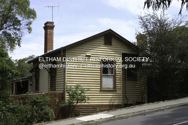
Photograph - Digital Photograph, Alan King, Sweeney's Cottage, Sweeneys Lane, Eltham, 30 January 2008
Part of the original cottage named Culla Hill built by Thomas Sweeney (a former convict) remains as a small section of today’s house. Covered under Heritage Overlay, Nillumbik Planning Scheme National Estate National Trust of Australia (Victoria) Local Sifgnificance Published: Nillumbik Now and Then / Marguerite Marshall 2008; photographs Alan King with Marguerite Marshall.; p19 Thomas Sweeney, a former convict who became a respected citizen, once lived on a property at what is now the corner of Sweeneys Lane and Culla Hill, Eltham. As Sweeney was one of the district’s first settlers, the property is registered by the National Trust. Thomas Sweeney was born in 1802, son of impoverished tenant farmers in Tipperary County, Ireland. He became a ploughman, then at 21 he was sentenced to hang for setting on fire the house of Patrick Guyder at Gullshill. It is said the arson was due to a dispute over undelivered guns to a social justice guerilla group, the White Boys, of which Sweeney was a member. But the sentence was commuted to life transportation to Australia in 1823.1 Apparently in Sydney he became a servant to James Chandler at Botany. Soon James Chandler leased his farm and became a catechist on the Hawkesbury River, so Sweeney was reassigned to a former convict, John Brown, at Liverpool. Later Sweeney was assigned to George Brown of Lake Illawarra. In 1831, Sweeney was granted a ticket-of-leave and bought a boat to carry goods between Illawarra district and Sydney Town. He married his first wife who had come to Australia as a free woman. However she drowned after bearing him a daughter. In 1838, one month after he had received a conditional pardon, Sweeney married a blacksmith’s daughter, Margaret Meehan, newly arrived from Ireland. They then moved to Port Phillip and squatted on the south side of the Yarra River, about seven miles (11km) from Melbourne. Around 1842, Sweeney bought 110 acres (44.5ha) in the parish of Nillumbik for £110. He built a slab hut 12 x 10 feet (3.6m x 3m) and then his homestead, Culla Hill, a typical Tipperary style cottage, now known as Sweeney’s Cottage. It was here that many generations of Sweeneys lived for almost 100 years. Culla Hill became a social centre for the district and the Catholic community used it as a church. Sweeney was apparently on good terms with a tribe of Aborigines living on the river nearby, who helped him build his house.2 Sweeney proved himself a civic-minded leader. In 1844, he led a call for a bridge over the Plenty River. He was on the first school board and supplied the first grain for Eltham’s mill. Sweeney profited during the gold rush, not by gold digging, but by providing supplies for nearby fields and others as far away as Beechworth.3 Thomas Sweeney died in 1867 and was buried at the Eltham Cemetery, leaving two sons, five daughters, and 300 acres (121.4ha), as well as Culla Hill. Culla Hill – by then reduced to 75 acres (30ha) – was sold out of the family in 1939, then renamed Sweeneys. The present Sweeneys Lane, running diagonally through the original holding, was the track to the house. Part of the original cottage remains as a small section of today’s house. The dining-family room fronted by a veranda is original, and although there have been some changes, the cedar door and most of the small 12-paned wooden-framed windows are original. The walls are made of the original hand-made brick. After buying the property in 1952 Mr and Mrs Burston demolished a dilapidated slab hut, a three-roomed detached kitchen and cellar, as materials needed to restore them were very difficult to obtain so soon after the war.4 However the barn remains almost in its original condition. It is believed to have been built from stone quarried on the property. Now roofed with iron sheets it was probably originally thatched. The sandstone barn has a peaked roof supported by the original saplings and a doorway large enough to accommodate a fully loaded wagon.This collection of almost 130 photos about places and people within the Shire of Nillumbik, an urban and rural municipality in Melbourne's north, contributes to an understanding of the history of the Shire. Published in 2008 immediately prior to the Black Saturday bushfires of February 7, 2009, it documents sites that were impacted, and in some cases destroyed by the fires. It includes photographs taken especially for the publication, creating a unique time capsule representing the Shire in the early 21st century. It remains the most recent comprehenesive publication devoted to the Shire's history connecting local residents to the past. nillumbik now and then (marshall-king) collection, culla hill, eltham, sweeney's cottage, sweeneys lane, thomas sweeney -
 Eltham District Historical Society Inc
Photograph - Digital Photograph, Alan King, Kinglake National Park, 27 March 2008
Fern gullies around Jehosaphat Gully Covered under National Estate. Published: Nillumbik Now and Then / Marguerite Marshall 2008; photographs Alan King with Marguerite Marshall.; p125 The magnificent Kinglake National Park, fringing Nillumbik’s north, is the largest national park close to Melbourne. Thanks to the vision and hard work of a band of local people, the park was created from what was rapidly becoming degraded land. Seeing a threat to Kinglake’s indigenous flora and fauna, several prominent local people campaigned for a national park, which was established in 1928.1 Since then, the park has grown through donations and acquisitions of land, from around 13,800 acres of land (5585ha) to 22,360 hectares. The Sugarloaf and Everard Blocks – of almost 8000 hectares – stand in Nillumbik and the park extends into Mitchell and Murrundindi Shires and the City of Whittlesea. Mt Everard commemorates William Hugh Everard, State member for Evelyn when the park was established. Before 1928, European settlers had degraded the Kinglake area, which was named after the celebrated English author and lawyer, Alexander William Kinglake. Remains of gold shafts and diggings in the park are reminders of Kinglake’s first settlers, who hoped to strike it rich at the gold diggings. But like other gold fields in this shire, they proved not very lucrative and soon timber cutting replaced mining in importance. However, before long, the accessible timber supply ran out, so in the 1920s agriculture took over – particularly potatoes and berry fruits – which involved large-scale clearing.2 The park’s instigator was retired Melbourne University Professor of Music, William Laver.3 As chair of the Kinglake Progress Association he began negotiations to have crown lands on the southern scarp of the Great Dividing Range reserved as a national park. Even before the park was proclaimed, from 1927, KPA members cut tracks to the major scenic points. Professor Laver was one of several people who gave land for the park, donating around 50 acres (20ha), including the Jehosaphat Gully.4 Laver chaired the park’s first Committee of Management, which raised money to employ a ranger and provide facilities, including tracks and roads for fire protection vehicles, toilets and shelters. The committee charged fees for firewood collection, some grazing of livestock, and visitor entrance, and obtained small State Government and Eltham Shire grants. In 1957 the State Government provided revenue for national parks. Then, in 1975, the State Government took over the management and the Committee of Management became an advisory committee, which disbanded in 1978. Originally, the park covered crown land in the Shires of Eltham and Whittlesea; then Wombelano Falls in Yea and other areas were added. In 1970 the park extended into the Shires of Eltham, Healesville, Whittlesea and Yea.5 Bush fires have been an ongoing problem. In 1939 hundreds of eucalypts and acacias had to be sown around the Jehosaphat Gully to rejuvenate the forest. To manage bushfires, the Committee of Management, then the State Government, worked closely with the Forestry Commission, shire councils and local fire brigades. Early national parks focussed on recreation. But by the 1980s, conservation, education and scientific research became more important, playing a vital role in preserving representative samples of the natural environment. Each year many thousands of people use the park’s extensive network of walking tracks amongst the protected plant and animal life as well as camping, cycling and horse riding. The park, along the slopes of the Great Dividing Range, has lookouts revealing magnificent views of the Melbourne skyline, Port Phillip Bay, the Yarra Valley and the You Yangs. Vegetation in the Masons Falls area includes messmate forest, Austral grass-trees, ferns and Hazel Pomaderris. In spring, orchids, lilies, everlasting daisies, correas, grevillea and heath appear. Around Jehosaphat Gully are wet and dry forest, fern gullies and banksia. Animal life includes wallabies, kangaroos, koalas, echidnas, possums, gliders and bandicoots. Male lyrebirds can be heard mimicking in the Jehosaphat Gully, particularly in the Everard Block in winter.This collection of almost 130 photos about places and people within the Shire of Nillumbik, an urban and rural municipality in Melbourne's north, contributes to an understanding of the history of the Shire. Published in 2008 immediately prior to the Black Saturday bushfires of February 7, 2009, it documents sites that were impacted, and in some cases destroyed by the fires. It includes photographs taken especially for the publication, creating a unique time capsule representing the Shire in the early 21st century. It remains the most recent comprehenesive publication devoted to the Shire's history connecting local residents to the past. nillumbik now and then (marshall-king) collection, kinglake national park, jehosaphat gully -
 Eltham District Historical Society Inc
Photograph - Digital Photograph, Marguerite Marshall, Jesse Tree playing the Didgeridoo and Swiss Hang Drum at St Andrews Market, 29 March 2008
Published: Nillumbik Now and Then / Marguerite Marshall 2008; photographs Alan King with Marguerite Marshall.; p175 It’s Saturday morning and thousands of people are visiting St Andrews Market at the corner of Heidelberg-Kinglake Road and Proctor Street. It’s hard to find a park. Cars are banked up along the narrow road and crammed in a nearby parking area. Yet, at the market, people look relaxed and happy amongst the yellow box gums on the site where the Wurundjeri people used to gather. Stone artefacts unearthed there by Koorie researcher, Isabel Ellender, indicate the site was once a Wurundjeri meeting place, according to Aboriginal Affairs Victoria. Acoustic sounds mingle with quiet conversations. A guitarist blows a mouth organ while his bare toes tickle chimes. A tiny busker, perhaps five years old, plays a violin while sounds of a harp emerge from the hall. One stallholder, selling delicious-looking pastries, chats to another in Spanish, then to me in broad Australian. ‘I was born in Fitzroy but my mother came from Mexico and my dad from Serbia,’ she smiles. A New Zealander fell in love with Mongolia and now imports their hand-made embroidered clothes and Yurts (tents) and runs adventure tours. A young woman visited Morocco and when friends admired the shoes she bought, she decided to import them and sell them at the market. Oxfam sells Fair Trade toys and clothes and displays a petition to Make Poverty History. Other stalls sell Himalayan salt, jewellery made from seeds from northern Australia, glass paper-weights from China as well as locally grown vegetables, flowers and organic freshly baked bread. A woman sits in a state of bliss under the hands of a masseur. Another offers Reiki or spiritual healing. A juggler tosses devil sticks – ‘not really about the devil,’ he smiles. This skill was practised thousands of years ago in Egypt and South America he says. At the Chai Tent people lounge on cushions in leisurely conversation. The idea for the market was first mooted among friends over a meal at the home of famous jazz and gospel singer Judy Jacques.2 Jacques remembers a discussion with several local artists including Marlene Pugh, Eric Beach, Les Kossatz, Ray Newell and Peter Wallace. ‘We decided we wanted a meeting place, where all the different factions of locals could meet on common ground, sell their goodies and get to know one another,’ Jacques recalls. They chose the site opposite another meeting place, St Andrews Pub. A week later Jacques rode her horse around the district and encouraged her neighbours to come along to the site to buy or sell. On February 23, 1973, about 20 stallholders arrived with tables. They traded ‘second-hand clothes, vegetables, meat, cheese, eggs, chickens, goats, scones, tea, garden pots and peacock feathers’. Now around 2000 people visit each Saturday. People usually linger until dusk. The market – with around 150 stalls of wares from a wide variety of cultures – stands alongside Montsalvat as the most popular tourist attraction in Nillumbik. By the 1990s St Andrews Market was in danger of being loved to death, as the site was becoming seriously degraded. The market was spreading in all directions and the degradation with it. A local council arborist’s report in 1994 noted exposed tree roots from erosion and compaction. The Department of Sustainability and Environment threatened to close the market if the degradation was not rectified. After many months of research, discussions and lobbying by a few residents, the council formed a Committee of Management, with an Advisory Committee, and introduced an Environment Levy. The State Government, the council and the market, funded terracing of the site to stop erosion, and retain moisture and nutrients. Vehicles were excluded from some sensitive areas and other crucial zones reserved for re-vegetation. Volunteers planted more than 3000 locally grown indigenous species. The old Yellow Box trees fully recovered and are expected to give shade for many years to come.This collection of almost 130 photos about places and people within the Shire of Nillumbik, an urban and rural municipality in Melbourne's north, contributes to an understanding of the history of the Shire. Published in 2008 immediately prior to the Black Saturday bushfires of February 7, 2009, it documents sites that were impacted, and in some cases destroyed by the fires. It includes photographs taken especially for the publication, creating a unique time capsule representing the Shire in the early 21st century. It remains the most recent comprehenesive publication devoted to the Shire's history connecting local residents to the past. nillumbik now and then (marshall-king) collection, didgeridoo, jesse tree, st andrews market, swiss hang drum -
 Eltham District Historical Society Inc
Photograph - Digital Photograph, Alan King, Blue Lake, Plenty Gorge Park, 2008
A quarry was transformed into the Blue Lake. Published: Nillumbik Now and Then / Marguerite Marshall 2008; photographs Alan King with Marguerite Marshall.; p179 The dramatic steep-sided Plenty Gorge lies along the divide of two geological areas, and separates the Nillumbik Shire and the City of Whittlesea. On the Nillumbik side are undulating hills and sedimentary rock, and in Whittlesea, lies a basalt plain formed by volcanic action up to two million years ago. This provides the Plenty Gorge Park with diverse vegetation and habitats, making it one of Greater Melbourne’s most important refuges for threatened and significant species. The park, established in 1986, consists of around 1350 hectares, and extends 11 kilometres along the Plenty River, from Greensborough to Mernda. It provides a wildlife corridor for around 500 native plant and 280 animal species. The area’s plentiful food and water attracted the Wurundjeri Aboriginal people and then European settlers. By 1837 squatters had claimed large runs of land for their sheep and cattle. The Plenty Valley was among the first in the Port Phillip District to be settled - mainly in the less heavily timbered west - and was proclaimed a settled district in 1841.But by the late 1880s, the settlers’ extensive land clearing for animal grazing, then agriculture, depleted the Wurundjeri’s traditional food sources, which helped to drive them away. Many Wurundjeri artefacts remain (now government protected), and so far 57 sites have been identified in the park, including scarred trees, burial areas and stone artefacts. Pioneer life could be very hard because of isolation, flooding, bushfires and bushrangers. Following the Black Thursday bushfires of 1851, basalt was quarried to build more fire-resistant homes. Gold discoveries in the early 1850s swelled the population, particularly around Smugglers Gully; but food production made more of an impact. In the late 1850s wheat production supplanted grazing. In the 1860s the government made small holdings available to poorer settlers. These had the greatest effect on the district, particularly in Doreen and Yarrambat, where orchards were established from the 1880s to 1914. Links with a prominent early family are the remains of Stuchbery Farm, by the river’s edge bounded by Smugglers Gully to the north and La Trobe Road, Yarrambat, to the east. The Stuchberys moved to the valley in 1890, and the family still lives in the area. In 1890, Alfred and Ada first lived in a tent where four children were born, then Alfred built the house and outbuildings around 1896. They planted an orchard, then a market garden, and developed a dairy. The family belonged to the local Methodist and tennis communities. Their grandson Walter, opened the Flying Scotsman Model Railway Museum in Yarrambat, which his widow, Vi, continues to run. Wal was also the Yarrambat CFA Captain for 22 years until 1987. Walter sold 24 hectares in 1976 for development - now Vista Court - and in 1990, the remaining 22.6 hectares for the park. Remaining are an early stone dairy and remnants of a stone barn, a pig sty and a well. Until it was destroyed by fire in 2003, a slab hut stood on the Happy Hollow Farm site, at the southern end of the park. The hut is thought to have been built in the Depression around 1893. This was a rare and late example of a slab hut with a domestic orchard close to Melbourne. Emmet Watmough and his family first occupied the hut, followed by a succession of families, until the Bell family bought it around 1948. There they led a subsistence lifestyle for 50 years, despite encroaching Melbourne suburbia. The Yellow Gum Recreation Area includes the Blue Lake, coloured turquoise at certain times of the year. Following the 1957 bushfires, this area was quarried by Reid Quarries Pty Ltd for Melbourne’s first skyscrapers, then by Boral Australia. However in the early 1970s water began seeping into the quarry forming the Blue Lake and the quarry was closed. The State Government bought the site in 1997 and opened it as a park in 1999.This collection of almost 130 photos about places and people within the Shire of Nillumbik, an urban and rural municipality in Melbourne's north, contributes to an understanding of the history of the Shire. Published in 2008 immediately prior to the Black Saturday bushfires of February 7, 2009, it documents sites that were impacted, and in some cases destroyed by the fires. It includes photographs taken especially for the publication, creating a unique time capsule representing the Shire in the early 21st century. It remains the most recent comprehenesive publication devoted to the Shire's history connecting local residents to the past. nillumbik now and then (marshall-king) collection, blue lake, plenty gorge park -
 Eltham District Historical Society Inc
Photograph - Digital Photograph, Alan King, Diamond Creek, Barak Bushlands, Eltham, 2008
A habitat corridor and it strengthens the community. Published: Nillumbik Now and Then / Marguerite Marshall 2008; photographs Alan King with Marguerite Marshall.; p185 Barak Bushlands lie west of the Diamond Creek on the corner of Falkiner Street and busy, noisy Main Road. They form part of an important habitat corridor linking the Yarra River to the Kinglake National Park.1 Manna Gums, tawny frogmouths and platypuses are some of the indigenous plants and animals that have made their home there. The bushlands are the result of more than nine years of hard work by the local community with the Nillumbik Council, to transform a degraded flood plain into this refuge of natural beauty. In 1997, shortly after moving into the new Riverside Estate on Falkiner Street, Eltham, several residents noticed the sorry state of the Diamond Creek and surrounding area. Part of it was used as a cow paddock and although small patches of vegetation survived, the area was infested with weeds, rabbits, rubbish and drainage from the housing estate. At various times the 4.4 hectares had been used as a market garden and for shire stock piles. The residents began to restore the area by revegetating land along the Diamond Creek. In 1998 they established the Friends of the Diamond Creek Falkiner Street Reserve2 and 35 families joined from the 90-house Estate. Carolyn Mellor, as the Friends’ Land Manager, undertook a four-year horticulture course to guide this massive project for a volunteer organisation. Since 1999, she has been the Friends’ President. In 1999 the Friends urged the Nillumbik Council to undertake a feasibility study into establishing a wetland system and urban forest. Work began in 2002 with Nillumbik Council funding the project, supplemented by government grants. The Friends also received grants from Melbourne Water and Parks Victoria. Aided by the Friends and other community members, the Council created the Barak Bushlands consisting of a forest, a wetland, a bridge, a path and open space. The beautiful wetland treats most of the estate’s stormwater runoff. Storm water is filtered through plants in the wetland ponds then is released slowly into the billabong, before flowing into the Diamond Creek. The wetland also helps to minimise flooding and the improved water quality provides a flora and fauna habitat. The Friends and other volunteers planted more than 27,000 plants, more than one third of which they grew from seeds they collected at Lower Eltham and Wingrove Parks. Eltham High School students planted thousands of these through a Year Eight program introduced for this purpose. Other groups who assisted were: Green Corps, local Scouts and Guides – 2nd Montmorency, 1st Diamond Creek and 1st Eltham Cub Packs, Eltham College students, Eltham East Primary School, Landcare members, Eltham Lions Club and the Eltham Baptist Church. To maintain enthusiasm for the mammoth task, the Friends and other volunteers ‘adopted’ trees to water and wrote their names on the stakes. In 2004, to recognise the area’s original occupiers, the reserve was named Barak Bushlands. William Barak, who lived from 1824 to 1903, was the last chief of the Yarra Yarra tribe of the Wurundjeri-willam people. Traces of these original inhabitants remain in scar trees (bark sections removed to make a shield or canoe). That same year the Friends’ group was a finalist in the prestigious Federal Government, Banksia Environmental Awards. The Friends have also participated in Clean Up Australia, removing tonnes of rubbish and regularly testing the billabong, wetland and creek, for pollutants. For years the Friends, together with the Australian Platypus Conservancy, have tagged, measured and checked the health of platypuses from the Diamond and Mullum Mullum Creeks. With Latrobe University the Friends have conducted night walks to view owls, possums, bats and sugar gliders. Challenges for the council and the Friends continue with a large rabbit population, some vandalism, weed eradication and maintenance. However, thanks to this community effort, locals can now escape confined urban living on small blocks of land and enjoy the beauty of indigenous plants and animals. Working together has also strengthened the local community,This collection of almost 130 photos about places and people within the Shire of Nillumbik, an urban and rural municipality in Melbourne's north, contributes to an understanding of the history of the Shire. Published in 2008 immediately prior to the Black Saturday bushfires of February 7, 2009, it documents sites that were impacted, and in some cases destroyed by the fires. It includes photographs taken especially for the publication, creating a unique time capsule representing the Shire in the early 21st century. It remains the most recent comprehenesive publication devoted to the Shire's history connecting local residents to the past. nillumbik now and then (marshall-king) collection, barak bushlands, diamond creek (creek), eltham -
 Eltham District Historical Society Inc
Photograph - Digital Photograph, Alan King, Pauline Toner Butterfly Reserve, 2008
One of seven sites in Eltham and Greensborough where the butterfly survives. Published: Nillumbik Now and Then / Marguerite Marshall 2008; photographs Alan King with Marguerite Marshall.; p181 The rare Eltham Copper Butterfly, Paralucia pyro-discus, was saved from near extinction by a community campaign in the late 1980s. Thanks to that effort, the butterfly, a form of the Fiery Copper Butterfly, with a wing span of only 2.5cm, can be seen in parts of Eltham and Greensborough from late November to April. As late as 1987 the butterfly was thought to be near extinction. But that year, entomologist, Michael Braby, found several colonies, including two major ones in natural bushland on Diosma Road, Eltham. However these were threatened with destruction, as their habitat was to be destroyed by a development of 71 houses. The colonies were on a 14 hectare subdivision owned by Esanda Finance, an ANZ Bank subsidiary. It would cost around $5 million, to reimburse the bank for the land. The butterfly, which depends on woodland, a stunted form of the Sweet Bursaria bush, and the Notoncus ant, was considered too fragile to relocate. Braby’s discovery led to a sometimes fiery two-year campaign, which even became an election issue. It involved the local community, local and state governments and the developer, before a compromise was reached. The larvae have an intricate relationship with the small black ant, Notoncus. During the day, the larvae shelter in nests made by the ants around the base of the trunk and roots of the Sweet Bursaria (Bursaria spinosa). The ants are thought to protect the larvae from predators and parasites, as they attend them from the nests to feed on the Bursaria leaves at night. In return, the larvae excrete a sugar solution, which the ants love to eat. The butterfly was first recorded in Victoria in 1893, and first collected scientifically from Eltham in 1931. But it was only officially named in 1951, by Victoria’s then top butterfly expert, David Crosby.2 However, from 1970, rapid housing development in Eltham destroyed much of the butterfly’s habitat. The discovery of several major colonies in 1987 met with great excitement, and 250 people attended the first local public meeting. The State Government commissioned Crosby to investigate how to protect the butterfly, and the council froze development for three weeks. Then Esanda agreed to suspend development for several months, until a compromise was reached. Crosby recommended that 62 of the 71 lots be kept to ensure the butterflys’ survival. However this would cost $1 million to $1.5million in compensation to Esanda. Greensborough MP Pauline Toner, launched a $1million fundraising campaign and many artists donated their works to the appeal. Toner offered Clifton Pugh’s painting Eltham Copper Country to millionaire Alan Bond for $1 million, after having heard that he had offered $6 million for the Van Gough painting Sunflowers. However Bond did not accept. The butterfly was considered a ‘hot’ election issue during the by-election, following Pauline Toner’s resignation. Liberal party candidate, Margaret Brown, was accused of falsely saying she had been involved in the butterfly campaign so as to win votes. Sadly, the $1million appeal fell short at $426,000, so a compromise was reached. The State Government donated the Education Department site on Eucalyptus Road, but only nine lots of the Diosma site were bought, and the rest of the development went ahead. On March 3, 1989, Ms Toner died. Thee Eucalyptus Road site was named in her honour. Around 2000 the butterfly was further threatened by proposed developments on Pitt Street, facing the Pauline Toner Reserve and between Diosma and Nyora Roads. Fortunately the Friends of the ECB, with the Shire of Nillumbik, ensured that more habitat was made available. The butterfly now survives in seven sites in Eltham and Greensborough, including the main sites at the Pauline Toner Reserve on Eucalyptus Road, the Western and Eastern colonies on Diosma Road, and the Yandell Reserve in Greensborough.5 The butterfly survives also in Castlemaine and in the Kiata and Salisbury areas. However, it remains endangered.This collection of almost 130 photos about places and people within the Shire of Nillumbik, an urban and rural municipality in Melbourne's north, contributes to an understanding of the history of the Shire. Published in 2008 immediately prior to the Black Saturday bushfires of February 7, 2009, it documents sites that were impacted, and in some cases destroyed by the fires. It includes photographs taken especially for the publication, creating a unique time capsule representing the Shire in the early 21st century. It remains the most recent comprehenesive publication devoted to the Shire's history connecting local residents to the past. nillumbik now and then (marshall-king) collection, eltham copper butterfly, pauline toner butterfly reserve -
 Eltham District Historical Society Inc
Photograph - Digital Photograph, Alan King, Sign: Clara Southern, Heidelberg School Artists Trail, Main Road, Research, 2008
Warrandyte artist, Clara Southern, features on the Artists Trail. Published: Nillumbik Now and Then / Marguerite Marshall 2008; photographs Alan King with Marguerite Marshall.; p189 Since early in the 20th century this district has attracted artists and other creative people. So much so, that Eltham has been compared to the Left Bank in Paris, New York’s Greenwich Village and London’s Bloomsbury. That is until the 1970s when Eltham rapidly expanded into a suburb. However many artists still flourish not only in Montsalvat, Dunmoochin and the Bend of Islands but elsewhere in Nillumbik. Some artists who have worked or lived in Nillumbik are well-known nationally and internationally. Artists are attracted to the hilly district’s subtle colours, unique light and the Yarra River and Diamond Creek. The railway’s extension to Eltham in 1902 brought artists to paint for the day or to camp. Then many settled in Eltham, perhaps also because the poor quality land, far from the city, was cheap. Following World War Two they found they could build houses and studios cheaply by making their own mud-bricks. The flexible material, with its warm tones blending into the bush, also satisfied their aesthetic sensibilities. As early as 1900, Will Longstaff, known for his painting The Ghosts of Menin Gate at the National War Memorial in Canberra, lived at Stanhope in Peter Street, Eltham, later to become the home of intellectuals Clem and Nina Christensen. Members of Australia’s first significant art movement, the Heidelberg School of Artists, painted in Eltham, Warrandyte and Diamond Creek. Walter Withers lived at the corner of Bolton and Brougham Street, Eltham and taught Sir Hans Heysen, who for a short while stayed with the Withers family. In Warrandyte were Clara Southern, whom Frederick McCubbin taught at the National Gallery School and Penleigh Boyd, who is represented in all Australian state galleries and the National Collection in Canberra. May Vale, daughter of politician William, lived in Diamond Creek. With Jane Price they feature on the Heidelberg School Artists Trail, part of which runs through Nillumbik. The trail includes signs each displaying a reproduction of a painting by an artist and located near where the artist lived or painted. In Nillumbik the trail includes parts of Warrandyte, Eltham in the Alistair Knox Park, Main Road shopping precinct and Wingrove Park, the Research walking track on Main Road and the Diamond Creek Reserve. In 1916 artist William ‘Jock’ Frater lived at the corner of Arthur and Bible Streets, Eltham. Before then, Frater, with other artists including Percy Leason (who moved to Eltham in the mid 1920s) painted in Eltham on weekends. They camped near Bible and Pitt Streets and along the Diamond Creek where the Eltham Retirement Centre now stands.4 In 1921, painter Peter Newbury (father to painter David Newbury, who was born in Eltham) moved to Cromwell Street, Eltham. Max Meldrum, the first Australian painter to formulate a consistent theory of art largely based on tone,5 taught local artists Alan Martin, Clarice Beckett, Peter Glass and Justus Jörgensen. Meldrum visited Eltham then rented a house there for 18 months opposite Wingrove Park. In 1934, artist and architect Justus Jörgensen and his doctor wife Lil and friends built Montsalvat, the artists’ colony. Montsalvat has played an important part in attracting artists to Eltham and its mud-brick, pisé, stone and recycled building materials has had a major influence on Eltham’s built environment. Jörgensen’s students who also helped him build Monstalvat included Arthur Munday, Lesley Sinclair, Helen Lempriere, Joe Hannan, Helen, Sonia and jeweller/sculptor, Matcham Skipper. Among artists who visited Montsalvat were Clifton Pugh and Angry Penguins’ artists Albert Tucker and Arthur Boyd. Some who painted after World War Two were Alan Martin of Eltham and Warrandyte artists Frank Crozier and Harry De Hartog6, one of Melbourne’s first painters influenced by Cubism.This collection of almost 130 photos about places and people within the Shire of Nillumbik, an urban and rural municipality in Melbourne's north, contributes to an understanding of the history of the Shire. Published in 2008 immediately prior to the Black Saturday bushfires of February 7, 2009, it documents sites that were impacted, and in some cases destroyed by the fires. It includes photographs taken especially for the publication, creating a unique time capsule representing the Shire in the early 21st century. It remains the most recent comprehenesive publication devoted to the Shire's history connecting local residents to the past. nillumbik now and then (marshall-king) collection, clara southern, main road, research (vic), heidelberg school artists trail -
 Federation University Historical Collection
Medal, Ballarat School of Mines Hillman Award (medal), c1992
Lindsay F.J. Hillman was born in Ballarat in 1910, and attended the Ballarat Junior Technical School. He became a cadet in Electrical Engineering Laboratory at the Ballarat School of Mines where he gained eventually gained a student Teachership for diploma studies at the School. Hillman was particularly active and excelled in a wide range of sporting interests and in student activities. In 1928 and 1928 he was awarded the Ballarat School of Mines Honour blazer by the Old Boys' association for all round athletic ability, leadership and scholarship. After spending two years with the Melbourne City Council Electric Supply Department gaining industrial experience Hillman was awarded his Diploma of electrical engineering in 1931, returning to the School in 1932 to teach apprentices and senior students. Hillman was appointed lecturer in Engineering Design and Graphics in 1937, lecturer in Engineering Design and Civil Engineering in 1944, Lecturer-in-Charge of Mechanical and Civil Engineering in 1948 and Head of the Electrical Engineering Department in 1949, a position he held until his retirement in 1973. In 1975 Lindsay Hillman was appointed to the Council of the Ballarat School of Mines and played an active role in school affairs.As Vice-President of Council from 1981 until his death in 1991 Hillman took a leading part in the implementation of many of the major building projects on the Lydiard Street Campus. The L.F.J. Hillman Award was established by the Ballarat School of Mines Council in conjunction with and through the generosity of the Hillman family in honour of the late Lindsay Frederick John Hillman. The bronze medal was presented annually to an enrolled student in an accredited course in the field of electrical/electronics studies at the Ballarat School of Mines. specific Criteria for the Award consisted of a balance of academic performance, leadership qualities, commitment to further study and involvement in sporting and/or community groups. Bronze medal designed depicting the portrait of Lindsay Hillman. The medal has a copper finish, and is presented in a blue hinged box. The first Hillman Award was presented in 1992. The recipients are: 1992 - Brett A. Hovey 1993 - Nil 1994 - Brent L. Ferguson 1995 - Kirsty McKenzie 1996 - Peter J. White 2000 - Roger Bush 2001 - Thomas Edward George 2002 - Mark William Holden 2003 - David James Hopwood 2004 - Leighton Dunn 2005 - Donald Pirouet 2006 - Mark Irvin 2007 - Ricky Wilson 2008 - Luther Dean 2009 - Daniel Thatcher 2010 - Craig Coulter 2011 - Sarah Draper 2012 - Rhys Hendrickson 2013 - Jayden Hooper "Lindsay Hillman Memorial Medal" Verso: "The School of Mines and Industries Ballarat, Est. 1870 Presented to "ballarat school of mines, hillman, lindsay hillman, medal, numismatics, honour blazer, electrical engineering, electronics, hillman medal, hillman award -
![Journal series, The Incorporated Council of Law Reporting for England and Wales, The law reports : Probate division : in the courts of probate and divorce : in the admiralty and ecclesiastical courts : and in the Privy Council [Family division and on appeal there from in the Court of Appeal and decisions in the ecclesiastical courts], 1869](/media/collectors/54a9bcce2162f11b1cc120f2/items/54b70efe2162f113803d6e56/item-media/54e69a7b2162ff01240c2a90/item-fit-380x285.jpg) RMIT GSBL Justice Smith Collection
RMIT GSBL Justice Smith CollectionJournal series, The Incorporated Council of Law Reporting for England and Wales, The law reports : Probate division : in the courts of probate and divorce : in the admiralty and ecclesiastical courts : and in the Privy Council [Family division and on appeal there from in the Court of Appeal and decisions in the ecclesiastical courts], 1869
Previous owners: T. H. Smith, T. W. SmithNo. of volumes: 124 Volume range: 1865-2014 (2008-2014 included within Chancery parts) Probate & divorce: Vol. 1 (1865) - Vol. 3 (1875) Probate: Vol. 1 (1875) - Vol. 15 (1890), Vol. 1891-1971 Family: Vol. 1972-2007 Editors: Bulwer, J. R. (1865-1885) Stone, A. P. (1886-1894) Pollock, F. (1895-1936) Topham, A. F. (1936-1939) Williams, R. E. L. V. (1940) Sutton, R. (1941-1952) Colinvaux, R. P. (1953-1968) Lamb, J. F. (1969) Ellis, C. J. (1970-1995) Williams, R. (1996-2007)law reports: digests: etc -- great britain, probate law and practice -- great britain -- cases, divorce -- great britain -- cases, admiralty -- great britain -- cases -
 University of Melbourne, Burnley Campus Archives
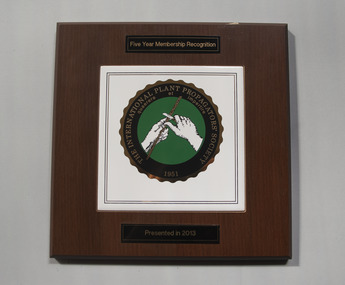
Plaque - Plaque and Research Agreement, The International Plant Propagators' Society Five Year Membership Recognition Plaque and Research Agreement Document, 1995 -2013
Plaque was presented in 2013 and was hung on the staff room walls until 2015. The letter to Ross Gregory Hall was written by Jolyon Burnett, Senior Industry Program Manager, granting funding for NY538 International Propagators Society Australian Region Annual Conference, Melbourne, May 1996. The agreement between The Horticultural Research and Development Corporation and the Faculty of Agriculture, Forestry and Horticulture for this project was signed by Gregory Moore, Principal of the College in 1995.1. Commerative plaque mounted on bevilled varnished wooden board for Five Year Membership Recognition (2008-2013). Presented in 2013 to the college. 2. Letter to Mr Ross Gregory Hall, Senior Lecturer (Production Management) dated 25 October 1995 from Jolyon Burnett of the Horticultural Research and Development Corporation (NSW) accepting his application for funding of the NY538 International Plant Propagators Society Australian Region Annual Conference Melbourne May 1996 3. Research Agreement between The Horticultural Research and Development Corporation and the Faculty of Agriculture, Forestry and Horticulture - Burnley for an approved NY538 project. Signed by Gregory Moore Principal of the College 27/11/1995 (6 A4 pages)1. Five Year Membership Recognition THE INTERNATIONAL PLATN PROPAGATORS' SOCIETY 1951 quaerere et impertire Presented in 2013. Logo in center.ross gregory hall, jolyon burnett, gregory moore, international plant propagators' society, annual conference 1996, burnley college -
 Orbost & District Historical Society
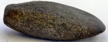
axe head
Inspected by Joanna Freslov, archaeologist 2/6/2008. Genuine Aboriginal axe head up to 2000 years old. Possibly came through trading from western district. Stone tools were used for a variety of purposes, in ways similar to those of the steel knives, axes, hammers and chisels. Ground-edge tools are made from fracture-resistant stone, such as basalt.This stone is able to withstand repeated impact, and and wqas generall used for stone axes. The stone was dug or found and then roughly shaped into a tool blank with blows from a hammerstone. The edges were then sharpened and refined by grinding the tool against a coarse, gritty rock. The necessary tools and equipment for hunting, fishing and warfare were one of the very few items that Aboriginals carried with them from place to place. Most were used for a multiplicity of purposes. Because many were made from raw natural materials, such as wood, generally only partial remains are found today. This axe head is an example of an early stone tool used by the Indigenous people of Victoria.Small grey oval-shaped axe head.axehead stone-artifact aboriginal tool -
 Warrnambool and District Historical Society Inc.
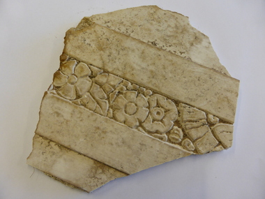
Buildings- Decoration, Plaster fragment from Criterion Hotel, Circa late 19th century
The Criterion Hotel was located on the western side of Kepler Street near the corner of Lava Street. John Tate of Woodford was the first licensee of the Criterion Hotel in 1873. The Humm family and the McGennan families were licensees for a considerable amount of time in the late 19th and 20th centuries. It was one of the last venues in the town to host live music. The last publican, John Palmer remembered it as a workers pub popular with local truckies and football clubs, in particular, Bushfield, Russell’s Creek and South Rovers. The Criterion closed in 2008 with the aim of turning it into office space but it was burnt beyond repair in 2010 and the remains were demolished in 2013.The Criterion Hotel was one of the earliest and longest licensed hotels in Warrnambool. As such it has local historical significance. The original building was an impressive landmark and the hotel itself has significant social importanceWhite plaster fragment with floral pattern enclosed within two plain borders. It is roughly five sided but edges are broken.criterion hotel, history of warrnambool, warrnambool hotels -
 Kiewa Valley Historical Society
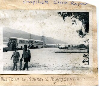
Photograph- Bus tour to Murray 2 Power Station
The Murray Region Hydroelectric Power Stations are two of seven hydro power stations, located near Khancoban in NSW. The two power stations are part of the Snowy Mountains Hydro-electricity Scheme, which is an extensive hydroelectricity and irrigation complex constructed in south-east Australia between 1949 and 1974 and now run by Snowy Hydro. Although both power stations are located in NSW, since 1 July 2008 all power generated has been allocated to the Victorian region of the National Electricity Market. Murray 2 Power Station was the first in the Snowy Scheme to use Japanese supplied large electrical and mechanical components Photographs demonstrate local Kiewa Valley residents enjoying an educational visit to Murray 2 Power Station which holds significance to the early history of the Hydro-electric Scheme in the area. Also demonstrates a pictorial history of social activities undertaken during this periodBlack and white photograph mounted on buff card Bus tour to Murray 2 Power Station showing 2 buses and group of Kiewa Valley residentsHandwritten in blue ink above photo "Snapshots Clare Roper' Handwritten in black ink below photo "Bus tour to Murray 2 Power Station'kiewa valley residents, clare roper -
 Kiewa Valley Historical Society
T-Shirt - High Country Line Dancers
Kiewa Valley Line Dancers meet regularly to move in unison to music while standing in lines. There are certain moves that are memorised to the music creating the effect of everyone moving together while facing one direction and dancing on their own. Line dancing has been around for a long time possibly originating from round & square dancing in the 1800s. In the 1990s country western music was influenced by the popularity of line dancing. Then ballroom rhythms and technique took line dancing to the next level. Line dancing reached Europe and in 2008 gained the attention of the French government. Line dancers dance to most styles of music and is popular throughout the world.This shirt belonged to Lorna Reid who lived in Tawonga in the Kiewa Valley. Line dancing began with Jim Budd in Mt Beauty in 1994 at the old Guide Hall with the assistance of the Neighbourhood Centre. Isla, a visiting teacher, with her husband Peter, continued classes at the Community Centre followed by Yvonne Sutton. At this time Social events were held with clubs from Myrtleford, Wodonga, Albury and Wangaratta. The next teacher was Joy Keith who held classes twice a week (Tuesday and Wednesday), with Eileen Speechly, from Gippsland, who held a class on Saturdays. In 2007, Robyn Quick took classes. An Intermediate class on Wednesday and Beginners on Friday. She visits Myrtleford once a week to learn from a teacher there. Line dancing is still (2018) enjoyed by many women in the Kiewa Valley giving them the opportunity to socialize and exercise together.Red polo shirt with collar and two red buttons at top front. Short sleeves. Front and back - black print of two 'mountains' with "High Country / Line Dancers / Kiewa Valley. Label size 18 "Player"kiewa valley line dancers, music, kiewa valley, tawonga, lorna reid -
 Uniting Church Archives - Synod of Victoria
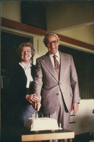
Photograph, Rev. Keith & Allison Pither, 1967
Keith Pither was born at Shepparton in 1914 and grew up on a farm. Attended Otira Methodist Home Mission Training College from 1936 and by 1939 was a probation minister at Burnie (Tas.). Enlisted in the army 1939 and served in the Middle East and Northern Australia. In 1943 he was ordained in the field as a chaplain and later served in New Guinea. Married Allison (Alison?) Brown in 1945 and they had four children, Brian, Rhonda, Andrew and Howard. Completed his studies at Melbourne University 1946. Placements were Red Cliffs, Carlton Methodist Mission, Benalla, Portland, Sandringham and Ivanhoe. Died 19/6/2008.The Pithers are holding a knife about to cut an anniversary cake."Rev. K. M. Pither and Mrs Allison Pither 1967"pither, keith, red cliffs, carlton methodist mission, benalla, portland, sandringham, ivanhoe -
 Unions Ballarat
Photograph: Flo O'Neill, Norm Borchers and Joan Kirner, June 1989
Joan Kirner served as a member of the state parliament from 1982-1994. Deputy Premier of Victoria, Minister of Education and subsequently Premier of Victoria (1990-92). Photo taken in June 1989. Norm Borchers passed away in 2008. Borchers was a Club President of the Sebastopol Lions Club (1975-76). He worked for the railways as an engineering employee and was long-term trade unionist (Amalgamated Engineering Union and the Australian Railways Union) and ALP member; he lived and worked in the Ballarat area. Norm was active in workplace disputes during the ALP split in 1955. He was a long time supporter of Ballarat Trades Hall.Photograph.btlc, ballarat trades and labour council, ballarat trades hall, kirner, joan, o'neill, flo, borchers, norm, politicians, state premiers -
Unions Ballarat
Photograph: Premier of Victoria John Cain, Nancye Cain and Norm Borchers, 21 June 1989
Picture (left to right): John Cain, Norm Borchers, Nancye Cain. John Cain was the 41st Premier of Victoria from 1982-1990. Nancye Cain (nee Williams) is his wife. Norm Borchers passed away in 2008. Borchers was a Club President of the Sebastopol Lions Club (1975-76). He worked for the railways as an engineering employee and was long-term trade unionist (Amalgamated Engineering Union and the Australian Railways Union) and ALP member; he lived and worked in the Ballarat area. Norm was active in workplace disputes during the ALP split in 1955. He was a long time supporter of Ballarat Trades Hall.Postcard sized invitation.John Cain's autograph sticky taped to the back of the photograph. Some descriptive text on the back of the photo.btlc, ballarat trades hall, ballarat trades and labour council, premier - victoria, cain, john, politicians, borchers, norm, cain, nancye, politicians' spouses -
Federation University Art Collection
Drawing, 'Copse' by Tony Hanning, 2015
Tony HANNING (1950- ) Dr Tony Hanning is an internationally recognised glass artist whose work is represented in all major collections in Australia and many overseas collections including the V&A Museum in London and the Tacoma Art Museum in the USA. The imagery in Tony Hanning's work often is representative of the Gippsland landscape. He has a PhD from Mondash University (2008), a Master of Arts from Monash University (1998); and a Diploma, Visual Arts, Gippsland Institute of Advanced Education, Monash University, Melbourne (1971). From 1971-1980 Tony Hanning was the Director of Latrobe Valley Arts Centre (later Latrobe Regional Gallery, Morwell)Framed and mounted charcoal drawing depicting large trees (conifers and probably deciduous) in a field rendered with hatchingLower right, signed Tony Hanning '15tony hanning, staffmember, landscape, trees, treescape, alumni -
 Melbourne Legacy
Document, President's Address - 'At Home Function', 2007
A copy of speech given by President Bill Rogers to the 'At Home' function on 18 October 2007. The function was Melbourne Legacy's way of saying thank you to the many valued friends who do so much in assisting Legacy in many different ways throughout the year. Two generous cheques were presented to Legacy, by Simon Kinch of the Blackburn RSL and Jim Stevens and Ray Skals from the Watsonia RSL. Watsonia RSL had donated over $188,000 in the preceding 10 years. Document was from a folder of documents donated to the archive by Legatee Bill Rogers that related to his time as President (March 2006 - March 2008).A record of the appreciation shown by Legacy to it's benefactors.Print out x 2 pages of a speech given by President Bill Rogers to legatees in 2007.fundraising, rsl, donations -
 Melbourne Legacy
Document - Speech, Legacy Week Address 2007 by Tom Uren, 2007
A copy of a speech by former Parliamentarian Tom Uren to open Legacy Week in 2007. He spoke of his war service and captivity as a POW on the Thai- Burma railway. He spent 1 and half years under the leadership of Sir Dunlop. Part of his time was at Hellfire pass (Konyu cutting) and Hintok (Hintock) camps. He relates his philosophy on life, some of it learned in captivity. That the strong should look after the weak (see page 5). Document was from a folder of documents donated to the archive by Legatee Bill Rogers that related to his time as President (March 2006 - March 2008).A record that Melbourne Legacy supplied updates to the media.Three A4 page photocopy of a speech by Tom Uren at the opening of Legacy Week in 2007.speakers, legacy week, tom uren -
 Melbourne Legacy
Document, Story Behind the Stamps, 2006
An article written by Legatee Bill Rogers about volunteers, led by Beryl Billing, who process used stamps for sale to fundraise for Legacy. The article may have appeared in the Bulletin. It acknowledged the huge amount of work Beryl had done over the years. Beryl's husband was a Legatee with Dandenong/West Gippsland Group (now called South Eastern). Beryl started the stamp group in February 1981 and over 27 years the stamp group raised $208,698. Document was from a folder of documents donated to the archive by Legatee Bill Rogers that related to his time as President (March 2006 - March 2008) or as a legatee.A record of the acknowledgement given to long-standing volunteers.One A4 page by Bill Rogers about Beryl Billing and the Stamp ladies.beryl billing, stamps -
 Melbourne Legacy
Document, From an address at a function held 4th November 1939, 2006
A typed copy of the speeches given on 4th November 1939 to farewell Stan Savige as he returned to the Army. It shows Sir John Gellibrand as patron of Legacy giving a toast to Stan Savige, as the Founder of Legacy. It includes Stan Savige's response which encompassed his views for the future of Legacy and the challenges coming during the war. Other copies in original documents are in the archive. Legatee Bill Rogers may have used parts of the speeches in his time as President. Document was from a folder of documents donated to the archive by Legatee Bill Rogers that related to his time as President (March 2006 - March 2008).An important link to Legatee Stan Savige, the founder of Legacy as well as the famous soldier, at a watershed moment in his life.Print out x 4 pages of a speech to toast Stan Savige as he returned to the Army in 1939.stan savige, sir john gellibrand, toast, speeches -
 Melbourne Legacy
Document - Speech, Launch of Legacy Badge Week, 2007
A speech by Legatee Bill Rogers to launch Legacy Week at the Queens Hall in the Victorian Parliament House on 30th August 2007. He thanks the host Mr Justin Madden MLC for the use of the venue. Also present was The Hon. Ted Ballieu MLA. he says: "Badge Week provides the opportunity to raise funds to support the many programs conducted by Melbourne Legacy. Legacy continues to care for and support the dependants of servicemen and women killed in the line of duty or who have died subsequently." Document was from a folder of documents donated to the archive by Legatee Bill Rogers that related to his time as President (March 2006 - March 2008).A record of a speech by a President at the launch of Legacy Week.Print out x 2 pages of a speech by Legatee Bill Rogers at the launch of Legacy Week.legacy week, speeches -
Eltham District Historical Society Inc
Document - Folder, Sibbel Builders Pty Ltd
Sibbel Builders was a partnership of brothers Herman and Martin Sibbel; they lived in Eltham. Their daughters Wilhelmina McCarroll and Fleur Sibbel founded the furniture design company Zuster. Contents Manningham Heritage Study report, 68-70 Olympus Drive, Lower Templestowe, 8 July 2005, pp260-261: Background of Sibbel Builders Printout: Research information, Sibbel Builders Pty Ltd. Details of Wilhelmina McCarroll and Fleur Sibbel and furniture design company Zuster. Newspaper advertisement: Diamond Valley Leader, 25 June 2008. 19 Spring Street, Greensborough, a Sibbel Classic house [reverse: 43 Para Road, Montmorency].Newspaper clippings, A4 photocopies, etcwilhelmina mccarroll, fleur sibbel, zuster furniture design, martin sibbel, herman sibbel, sibbel builders pty ltd, 19 spring street greensborough, 43 para road montmorency -
 Peninsula Grammar
Newsletter, The Peninsula School Gazette, August, 1961
The Gazette was a newsletter of Peninsula Grammar (formerly the Peninsula School) used to communicate to families of students and to highlight events, activities and achievements.Black and white printed newsletter, 6 pages.non-fictionThe Gazette was a newsletter of Peninsula Grammar (formerly the Peninsula School) used to communicate to families of students and to highlight events, activities and achievements.newsletters, foundation