Showing 1846 items matching "gippsland east"
-
 Orbost & District Historical Society
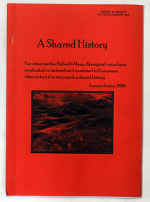
book, Peisley, Annette, A Shared History, 2006
... /European history of East Gippsland. genoa-history aboriginal ...This book is a useful research tool on the Aboriginal/European history of East Gippsland.A 31 pp book with a bright red/orange cover titled A Shared History a history of the Bidwell-Maap Aboriginal People and European contact history, Genoa district.genoa-history aboriginal-bidwell-maap -
 Orbost & District Historical Society
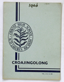
magazine, Croajingolong 1960, 1960
This is the thirteenth issue of the Orbost High School magazine. The name Croajingolong derives from the Australian Aboriginal Krauatungalung words galung, meaning "belonging to" and kraua, meaning "east". It belonged to Mary Gilbert, a former teacher at the school.This is the thirteenth issue of the Orbost High School magazine and is a useful reference tool.A magazine with a pale blue cover. Dark blue printing : Croajingolong and the Orbost High School crest of a sheaf of corn inside a double oval with Orbost High School and its motto " acti labores iucundi". Vol. No 13 1960.This publication has been professionally printed and contains photographs.croajingolong orbost-high-school -
 Orbost & District Historical Society
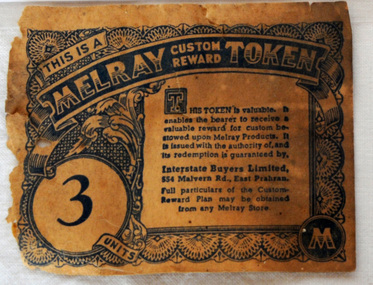
token, mid 20th century
" As well as preserving companies, various grocery chains, buying groups and wholesale co-operatives sold jam under their own brand names. One such company was Melray. Melray, founded in East Prahran, Melbourne, in 1932, was the forerunner of the Foodland chain (1958). It had branches across the country. Their jam labels included special reward tokens for redemption in-store. It is most likely that Melray jam was produced by Henry Jones’ Australasian Jam Company, or at least labelled at the iconic Jam Factory in South Yarra, Melbourne – a site of jam production in Australia for almost 100 years. Many Melray labels were discovered there, when the site was converted to a shopping centre in the 1970s, a period of industry-wide decline." (Information from australiapostcollectables web-site) The Melray Association of Independent Grocers consisted of the leading storekeepers throughout the State of Victoria, with a central headquarters and bulk store in Melbourne.These tokens were issued by Melray Stores as a reward for custom. This item is associated with the period when Australia produced and exported much more of its agricultural produce - including tinned jam.A paper token - Melray Custom Reward Token. This is a reward token issued by Melray for regular custom - 3 units.melray grocery-store custom commerce -
 Orbost & District Historical Society
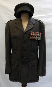
military uniform, Before 1939
This is the army uniform of James Chester Kerr Trewin a lieutenant in 2/7th and 58/59th Battalions. He served in the Middle East, Syria and New Guinea. James Trewin was wounded in action.This item gives an insight into the human element of World War 11 ensuring that those who were part of the Orbost community and played a vital role during this time are remembered.A khaki coloured WW11 jacket (male) with a cap. There are medals on a strip. Three bronze stars : 1939-1945 Star; Africa Star; Pacific Star. Round silver medals : 1939-1945 Defence Medal ; 1939-1945 Australian Service Medal . There is a Rising Sun - Australian Commonwealth Military Force - on the lapel and on the cap. On left sleeve is a strip of black and red bars.uniform-military trewin-james ww11 -
 Orbost & District Historical Society
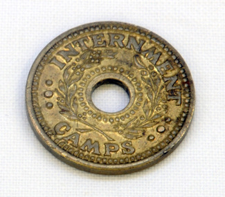
coin, Arendsen & Sons, WW11
For security reasons, tokens were used in Australian WW11 Internment Camps. They were introduced in 19433 to replace the paper canteen coupons. This token was used at the internment camp at Bete Bolong just outside Orbost during WW11. This camp was established in 1943 and was there until 1946. The internees had been transferred from the camp at Murchison East to provide farm labour. The coin was given to Lindsay Thomson when he was a student.This token was used at the Bete Bolong POW camp from 1943-1945. This camp housed Italian POWs, some of whom remained/returned after the war to settle in Orbost.An internment camp coin. This is a one penny coin token with a hole in the centre. It is made of brass.ONE PENNY INTERNMENT CAMPStoken ww11 bete-bolong internment-camp -
 Orbost & District Historical Society
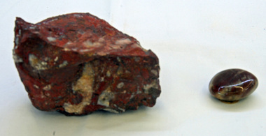
jasper fossils
... of the geological history of East Gippsland jasper fossil nautilloidea ...Presumed found in the Buchan area. Inspected by George Rawlings 6.2.2013Fossils are among the most valuable sources of information about the Earth's history. This fossil is part of the geological history of East GippslandTtwo pieces of jasper fossil. Genus-nautiloidea, family-cephalopoda, order - mollusca. Fossil of a cuttlefish like animal- head and tentacles protruding from one end of the long tubular shell. This is in red jasper. The small fossil piece has been polished.jasper fossil nautilloidea mollusc -
 Orbost & District Historical Society
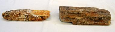
petrified wood
These pieces were found in the Genoa area approximately 150 kms east of Orbost.Two pieces of petrified wood.petrified-wood -
 Orbost & District Historical Society
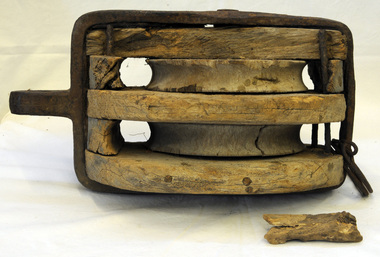
pulley
This pulley was found by Geoff Stevenson, on a beach near Cape Conran (east of Orbost). It probably came from a sailing ship which was wrecked there. Pulleys are simple devices for increasing mechanical advantage in a wire, chain or rope system. A pulley consists of a wheel with a specialized rim that rotates on an axle and carries some type of cable or chain. Ships used a variety of blocks (pulleys) for various tasks, such as stowing cargo or handling the sails. A large wooden pulley encased in iron. It was probably used on a sailing ship. pulley cape-conran sailing-ship maritime -
 Orbost & District Historical Society
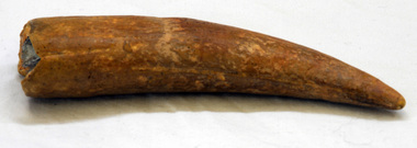
fossil
This fossil was found by Peter Cook just west of East Cape at Cape Conran (east of Orbost),. Original correspondence re its identification came from Andy Murray - Conservation & Natural Resources, Orbost. It was on display at the Orbost Visitor Information Centre - the Slab Hut.A fossil tooth from a marine species. It may be from a an extinct ziphiid or beaked whale (Warneke Marine Mammal Services 20.10.1993). It may be a fossil from a large species of subadult seal (Ewan Fordyce Senior Lecturer in Geology, University of Otago 11.10.1993).fossil-tooth whale seal marine cape-conran -
 Mission to Seafarers Victoria
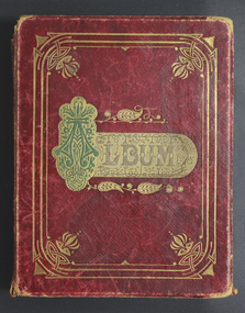
Book (Item) - Scrapbook, David Hood Duncan, Album, 1850-1900
This scrapbook contains newspaper cuttings, hand written poems and quotes from friends and family members and pressed flowers and ferns. Entries were made in the mid 1800s to early 1900s and relate to Duncan family history. The initials suggest this is Lillie and Olive's father, David Hood Duncan, who created this scrapbook. David Hood Duncan married Ada Blanche Thomson (1861-1928) on 25 November 1896. Ada was the daughter of John Gilmour Thomson (1829-1905) from Moonee Ponds and Hannah Davies (1834-1890) Their first daughter, Lillie, was born on 15 October 1897 in Woodland, South Gippsland where he was a farmer. In 1908, 1910, 1911, 1913, Lillie Duncan sent letters to Patience from the Young Folk section of the Australian. She was writing from Woodlea, Cathkin, where they had moved as there was no school in South Gippsland. They moved to 11 Paxton Street, East Malvern when David retired. He was leasing a farm, Kia Ora, in Koo Wee Rup, the South Gippsland. Ada Blanche died on 28 December 1928. David died on 24 May 1942.This is an album of social and historic significance, being part of a sub-collection of material that provides a snapshot of the type of individuals and families involved in the Ladies Harbour Lights Guild and the activities carried out by that organisation.Decoratively embossed word on front cover : "ALBUM" . Inner pages: Handwritten in various inks throughout are poems and quotes. Two unidentified initials followed by Duncan name on the inside page. duncan, poems, quotes, newspaper cuttings, albums, scrapbooks, lillie duncan, olive duncan, poetry, ferns, plants, david hood duncan, ada blanche duncan (nee thomson), epistolary -
 Orbost & District Historical Society
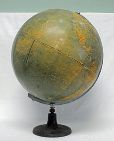
globe, C1958
... of education in East Gippsland. It is also associated with Evelyn ...This desk globe was owned by Evelyn Bessie Travaskis and used when teaching at State School Wairewa where she taught from 2-2-1945 until her retirement on 29-6-1956. She retired from the Education Department temporary staff, aged 76. ( More info.from Newsletter November 2015 by John Phillips). The Philips' Challenge Globe was commonly used in Australian schools in the teaching of geography. This item is associated with the history of education in East Gippsland. It is also associated with Evelyn Trevaskis.A large globe mounted on a round metal stand which has three holes for securing to a flat surface - a desk or tabletop. It sits in a half meridian.C 1958 Philips' Challenge Globetrevaskis-evelyn globe education-equipment-geography wairewa-school -
 Ringwood and District Historical Society
Name List, A suggested list of names suitable for streets in Ringwood, and showing origin of name - compiled 1970, c.1970
A suggested list of names suitable for streets in Ringwood, and showing origin of name. Two pages foolscap, 100 names approx. ; Hull: Surveyed Gippsland Road now Maroondah Highway, 1855 (Also name of roar in Croydon); Darke, Wm Wedge, Surveyed all land between Yarra and Western Port, including Ringwood - 1843; Wedge, Chas. Nephew of John Helder Wedge, Batman's surveyor, 1834. Active in Ringwood East Progress Association over 40 years ago.; "Barker's Track" - forerunner of Gippsland Road, Maroondah Highway.; Bickford, N Superintendent of Hodgkinson's Field Party of Surveyors etc. Original Land Owners; Isaacs,S. G. Bought first land in Ringwood - March 1858 - Lot 3; Moss, M.Lot 1 - April 1858; Davis, J. Lot 6 - April 1858; Riley, P. Lot 11 - April 1858; Marks, M.Lot 15 - November 1858; Wieland, C.F. Lot 14b - July 1872; Richter, K.H. Lot 14a - April 1869; Molloy, J. Lot 21 - December 1877; Watson, B. Lot 22a - April 1869; Stutt, W. Lot 27 - June 1884; Blood, R & W.Lot 42-3 - March 1872; Cox, J. Lot 41 - March 1870; Moncrieff, T.Lot 40a - September 1876; Pett, J. Lot 40b - January 1878; Feltham, F. Lot 28a - September 1881; Downing, J.J.Lot 32b - October 1881; Burge, W. Lot 39 - April 1875; Axford, W. Lot 32a - December 1877; Ball, E.A.Lot 37 - March 1869; Parker, G. Lot 28 - June 1882; Gangell, W.Lot 24a - January 1883; Hodgson, A.D. Lot 25a - May 1875; Muldowney, P. Lot 30d - June, 1877; Hosie, J.S. Lot 34, 30b - June 1878; Rourke, H.Lot 36 - July 1869; Duggan, T.Lot 35 - May 1870; Pach, W. Lot 30e - May 1884; Morris, J. Lot 25b - June 1882; Kleinert, A. Lot 29c - August 1886 +Additional Keywords: Hull / Darke, Wm Wedge / Wedge, Chas / Wedge, John Helder / Bickford, N -
 Warrnambool and District Historical Society Inc.
Map - Maps, Soldiers Settlement WW2, Circa 1950
The soldiers' settlement scheme operated after the first and second world wars in an effort to more closely settle the land and also give opportunities to returned soldiers. Crown land and other larger estates were acquired for the purpose. Most of these maps relate to the area north of Warrnambool where many of the subdivisions were parts of larger estates.These maps pertaining to the Soldiers' Settlement program, relate to an interesting part of Australian and local history. As such they have historic and social interest and significance.A collection of 25 paper maps which relate to to the soldiers settlement post World War 2. Some have details of the people allocated the land and some smaller maps have the printed details of the applicants requirements.Text is black on white paper which in some cases is quite aged. The maps are as follows: .1 Narrapumelap Estate ( Ripon & Hampden) .2 Narrapumelap Estate Part 2 (Villers & Ripon) .3 Narrapumelap Estate Part 3 ( Villiers & Ripon) .4 Burrumbeet Estate ( Ripon) .5 ' Berrambool' Estate 9 Hampden & Villiers) .6 ' Hopkins Hill' Estate Villiers 4011 acres .7 Caramut North No 2 Estate ( Villiers ) .8 ' Morpor' Estate ( Villiers) 4172 acres .9 ' Morgiana' Estate ( Normandy) 3453 acres .10 ' Chatsworth House' ( Villiers) 9341 Acres .11 ' East Elwood' Estate Villiers 2407 acres .12 Grey's Estate ( Mornington) 1151acres .13 ' Rowes Estate' ( Buln Buln Gippsland 733 acres .14 'Tarrone' Estate No 2 Part map .15 'Chaldon Meade' Estate (Bourke) Bulla 517 acres .16 ' Terranallum South' Estate Hampden 3757 acres .17 ' Brung Brungle' Estate Dundas 695 .18 ' Armidale ' Estate ( Dundas)2108 acres .19 ' Moyne Falls' Estate ( Villiers) 627 acres .20' Yulong' Estate 9 Lowan 6321 acres .21 Murray Valley Irrigation District 9 Moira)113 acres .22 Murray Valley Irrigation District 103 acres .23 ' Mount Fyans' Estate ( Hampden) .24 ' Barwidgee ' Estate ( Villiers) 4277 acres .25 'Pine Hills' Estate 2nd portion ( Lowan) 6190 acres narrapumelap, berrambool, hopkins hill, caramut north, morpor, chatsworth house, east elwood, terrinallum, moyne falls, tarrone, caramut soldiers settlers, burrumbeet, morgiana, grey's estate mornington, chaldon meade, brung brungle -
Glen Eira Historical Society
Document - Murrumbeena State School No. 3449
This file contains a photocopy of entry for Murrumbeena Primary School from a Caulfield Conservation Study by Andrew Ward, March 1995, noted in study are site address, a description of the building’s structure, history, references and statement of significance. Also in this file is a typed history of Murrumbeena Primary School with added hand – written notations. There is not author and it is undated.murrumbeena primary school, rosstown state school, multi – purpose hall, murrumbeena state school, gippsland railway, enrolment, hobart road murrumbeena, presbyterian church hall, out of school hours., statement of significnace, carnegie state school, east kew primary school, andrew ward., victorian public works department, staff and administration, maintenance. -
 Marysville & District Historical Society
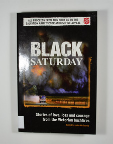
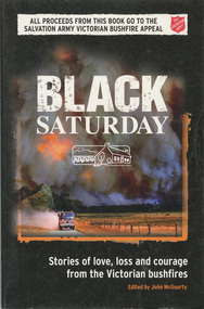
Book, John McGourty, Black Saturday-Stories of love, loss and courage from the Victorian bushfires, 2009
Stories of love, loss and courage from the Victorian bushfires on Black SaturdayFront cover has a photograph taken on Black Saturday by Alex Coppel from the Sunday Herald Sun; smoke from Black Saturday fires turns day into night as CFA volunteers race towards a new firefront at Labertouche. There is also a banner across the top of the front cover that says 'All proceeds from this book go to the Salvation Army Victorian Bushfire Appeal. non-fictionStories of love, loss and courage from the Victorian bushfires on Black Saturdaybushfire, black saturday, victoria, kilmore east, wandong, strathewen, kinglake west, st andrews, steels creek, kinglake, flowerdale, marysville, gippsland, bendigo, beechworth, medgegonga -
Federation University Historical Collection
Book, Federation University Annual Report, 2014, 2014
In 2014 Federation University Australia was formed with the merger of University of Ballarat and Monash University Gippsland Campus. Although formally created as a university in 1994, the University of Ballarat had a lineage back to 1870 with the establishment of the Ballarat School of Mines. With campuses from Horsham in the west of the state, to Churchill in the east, the name Federation University Austalia was chosen to convey the scope and capacity of an expanded regional university with a federation network of campuses contributing to a new and different Australian university.Hard copy and pdf of the 2014 Federation University Australia Annual Report. federation university annual report, paul hemming, david battersby, monash university gippsland campus, gippsland campus, university of ballarat, dennis napthine, pam sutcliffe, peter hall, robert ayton, don johns, stuart berzins, lyndel ward, adelaina horner, alison mcrae, mashelle parrett, steve davies, tony stone, ian nethercote, peter wilson, michael ryan, george fong, deborah spring, kim dowling, karen douglas, todd walker, meredith doig, marcia devlin, darren holland, andy smith, frank stagnitti, john blair, graeme ambrose, rowena coutts, john dixon, bernard o'meara, vicku rethuis -
Federation University Historical Collection
Photograph - Art Student, University of Ballarat Student study, c2005, c2005
Federation University Australia was established on 1 January 2014. Formerly known as the University of Ballarat, its enabling legislation was the University of Ballarat Amendment (Federation University Australia) Act 2013. Although formally created as a University in 1994, the University of Ballarat has a lineage back to 1870 with the establishment of the School of Mines Ballarat, making it the third institution of higher learning to be established in Australia and the first to be established in regional Australia. On 1 January 1994, Ballarat University College became the University of Ballarat and in 1998 the University merged with three TAFE Institutes to become a dual sector institution with multiple campuses. On 1 January 2014, the University of Ballarat amalgamated with the Monash University Gippsland Campus to form Federation University Australia. The Gippsland Campus also had a long lineage dating back to 1928 with the establishment of the Yallourn Technical School which became a predecessor institution to the Gippsland College of Advanced Education formed in 1968. In 1990, it was renamed the Monash University College and in 1993 became the Gippsland Campus of Monash University. In 2016, Federation University Australia announced plans to take possession, over a two-year period, of Monash’s Berwick Campus in the south-east corridor of Melbourne. Federation University Australia, or FedUni, is headquartered in Ballarat and offers programs in Higher Education and Vocational Education and Training to regional Victoria and beyond. The University’s commitment to educational and social equity, teaching excellence, research distinction, environmental sustainability and regional capacity building has enabled it to develop in a way that draws on its proud heritage to inform its future. Its regional character sets a framework for the University’s priorities but does not constrain it from serving wider community interests, nationally and internationally. The name Federation University Australia was chosen to convey the scope and capacity of an expanded regional university with a federated network of campuses.Colour photograph of students on the grass outside the Union Building on Mt Helen Campus.federation university, mount helen campus, students, alumni, art, painter -
 Bairnsdale RSL Sub-Branch Inc.
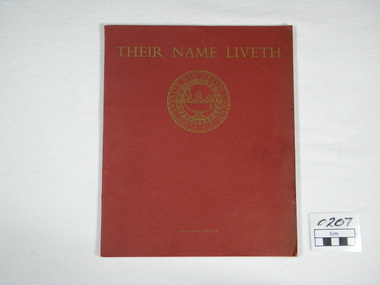
Commonwealth War Graves Commission, Her Majestry,s Stationary Office by the Campfield Press, Their Name Liveth Vol VI Part II, 1968
Some Pictures of War Cemeteries of South -East Asia,The Pacific Islands and Japan 1914-1918 and 1939-1945Red covered book Their name Liveth on top of cover Seal of Commonwealth War Graves Commission under TitleTheir Name Liveth Commonwealth War Graves Commissionjapan, war, east, port, islands, new, guinea, south, cemeteries, asia, pacific, fiji, caledonia, adelaide, rabaul, lea, morsby, labuan, yokohama, kranji, singaporechangi, kanchanaburi, thailand, thanbyuzayat, burma -
4th/19th Prince of Wales's Light Horse Regiment Unit History Room
Order of Ceremony, The Royal Australian Amored (sic) Corps the Keeffe Family & Eoghan McDonald Celebrates (sic) the Unveiling of a Commemorative Plaque 16 November 2014, 2014
The 13th Australian Armoured Regiment was a Gippsland militia unit that had been called up for full time duty in December 1941 as a traditional light horse regiment. The early months of 1942 had seen the regiment lose its horses, a conversion to a motor regiment and finally to an armoured regiment in May. During this period there were considerable changes in personnel, however the regiment maintained its strong links to Gippsland and its former identity. Between May and November 1942, individual soldiers had become proficient in their trade training and the regiment changed its focus to troop and squadron activities. On 16 November 1942, the unit was located at the Puckapunyal Army Camp. C Squadron's training program involved a night driving exercise where a column of armoured and B vehicles would depart camp at 0245 hours and proceed to a site to the East of Seymour and set up a bivouac between Whiteheads Creek and Highlands Road. Numerous army camps surrounded the Seymour area; and much of the surrounding farm land had been acquired for military purposes. By November 1942 exercises such as C Squadron's were commonplace and had been repeated on numerous occasions since 1939. At 0400 hrs, C Squadron's vehicles reached O'Sullivan's Paddock on the Kobyboyn Road; prior to reaching the Old Telegraph Road the column turned to the North towards a known crossing point on Whiteheads Creek. The column consisted of seven M3 Medium Tanks and four Universal Carriers. In the case of Corporal McLeod's vehicle, there were seven crewmen rather than the usual five man crew. On arrival at the creek crossing, Captain C.M.I. 'Sandy' Pearson dismounted and with the assistance of Sergeant R.J. Ball began to guide individual tanks across the creek. Four tanks had crossed the creek without difficulty when Corporal McLeod's tank, ARN 24652, began its descent. Captain Pearson stated at the Coroner's Inquiry in December 1942, "Whilst climbing out of the ford the vehicle swerved to the left, apparently striking the tree. It was not the portion of the tank (front) that struck the tree. The tank straightened and appeared to be well under control, suddenly the bank on the left collapsed to the extent of 3ft by 12ft by15ft long causing the vehicle to slide into the creek and turn upside down." Captain Pearson and Sergeant Ball were faced with a nightmarish situation: The Grant had come to rest upside down in soft mud, six crew members were unaccounted for, escape hatches could not be opened and the weight of the tank was settling deeper into the water and mud. Compounding the problem was that the location of the tank did not allow for the other tanks to safely conduct a recovery. It was truly the darkest night.Single A4 card. folded, Contains an account of the raising of 13 Armoured Regiment in December 1941and a tank accident during a night creek crossing in which six crewmen were killed, and, Order of Ceremony for plaque unveiling, Guest of Honour LtCol Stuart Cree CO/CI School of Armour13 armored regiment, tank accident, puckapunyal -
 Eltham District Historical Society Inc
Book, Black Saturday : Stories of love, loss and courage from the Victorian bushfires edited by John McGourty, 2009
The Black Saturday bushfires were a series of bushfires that ignited or were burning across the Australian state of Victoria on and around Saturday, 7 February 2009 and were Australia's all-time worst bushfire disasters. Contributions from reporters and photographers from News Limited. The book is a collection of individual stories, featuring deeply personal contributions from: people directly affected by the bushfires, their friends and relatives; the people who came to their aid - fire fighters, doctors, nurses and wildlife rescuers; accounts from journalists on the scene; and those involved in coordinating the response. Arranged town-by-town, with introductions detailing the scope and impact of the fires on each community. Contents: Kilmore East & Wandong - Strathewen & Kinglake West - St Andrews & Steels Creek - Kinglake - Flowerdale - Marysville--Gippsland -Beechworth & Mudgegonga - the lost ( listing those who perished ) - map of tragedy. Proceeds from the sale of each book was given to the Salvation Army Victorian Bushfire Appeal.SoftcoverYarra Plenty Regional Library identification sticker with name, number and bar code ISBN 9780732290108strathewen, st andrews, black saturday, fires -
 Orbost & District Historical Society
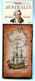
map, Shell Australia, 1970
This Shell road map was made as part of the 200 year celebration of Captain James Cook's voyage on the HM Endeavour and the first sighting of Australia at Point Hicks in 1770. The Bicentenary of James Cook in Australia was commemorated in Australia in 1970. The British explorer Lieutenant (later Captain) James Cook sailed and charted the East Coast of Australia in 1770, and claimed the eastern seaboard of the Continent for the British Crown. This was not considered the official bicentenary of Australia, but rather the mapping of the Eastern coastline. This item reflects the commemoration of a significant event in Australian history.A coloured foldout touring map of Australia with a picture of James Cook and the ship, Endeavour, on the front.map-australia bicentennial-cook-1970 -
 Orbost & District Historical Society
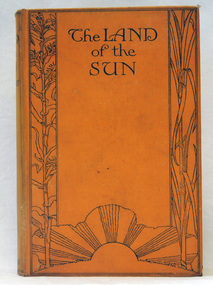
book, Butler & Tanner, The Land of the Sun, 1924
... an association with Mallacoota, a small town in the East Gippsland region ...This is the author's account of life in Northern Queensland. Edwin James Brady was an Australian poet. He was born at Carcoar, New South Wales, and was educated both in the United States and Sydney. He worked as a wharf clerk, a farmer, and journalist, and edited both rural and city newspapers. Brady established a writers' and artists' colony at Mallacoota, in 1909, and he continued to live there until his death in 1952. E. J. Brady was a leading figure of Australian literature. He has an association with Mallacoota, a small town in the East Gippsland region of Victoria, Australia. A 303 pp book with a hard back cloth covered bright orange cover. It is titled in black print " The Land of the Sun" and has black print illustrations of crops and the sun. It contains black/white plates and a fold-out map of Queensland.brady-edwin-james book--the-land-of-the-sun queensland-northern -
 Orbost & District Historical Society
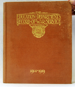
books, The Education Department's Record of War Service 1914 - 1919, 1921
... of the particpation of teachers of the East Gippsland area in World war 11 ...Teachers from all across Victoria enlisted in the Australian Imperial Army to fight overseas. 752 from the Victorian Education Department are listed as signing up. Many were teachers but also included were clerical staff, medical officers. Included in the book are details of the contributions made by others through donations of "comfort items" and subscriptions. There are details of The Young Workers' Patriotic Guild, the war savings effort in the schools and general school subscriptions. 703.1 was presented to Jarrahmond School and 703.2 to Corringle School. Neither school exists today. This is a useful reference tool for the study of the particpation of teachers of the East Gippsland area in World war 11.Two copies of a hard back book with a light brown/orange cover with the title, "The Education Department's Record of War Service 1914-1919' in gold print. It contains portraits and biographical notes on "the men who fell" and "the men who returned". world-war-11 department-of-education-victoria -
 Orbost & District Historical Society
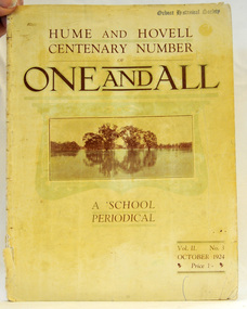
magazine, Clothier & Co, One And All, 1924
This magazine was circulated amongst the pupils, parents, and teachers of the Beechworth Inspectorate, North-East Victoria. This magazine is Vol. 2, no. 3 (Oct. 1924), Hume and Hovell Centenary Number.School magazines were the forerunners of today's school newsletters and were generally published annually. They are contemporary records of the students and staff of the school and usually contain examples of the students' work.This one, published to commemorate the centenary contains information on the Hume and Hovell expedition the purpose of which was to find new grazing land in the south of the colony, and also to find an answer to the mystery of where New South Wales's western rivers flowed. At the centenary of Hume and Hovell exploration in 1924 a committee was formed to co-ordinate and organise local celebrations along the route from Albury to Corio Bay. A roadside cairn was unveiled near Beechworth.A stapled school magazine with a cream coloured cover. It has an illustration of a river and trees reflected in the water on the front. The title, "ONE AND ALL" is at the top in black print. It has " Hume and Hovell Centenary Number" above the title.education-beechworth school-magazine-one-and-all -
 Orbost & District Historical Society
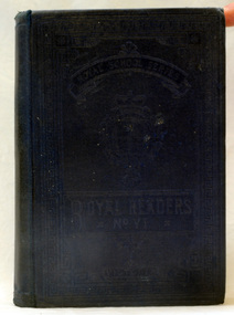
school text book, Thomas Nelson & Sons, Royal Readers No V1, 1895
... children in Victoria. It reflects the changes in education in East ...The Royal Readers had been prepared especially for Victorian schools and featured some Australian content. The authors made great use of the natural world as well as incidents and common daily events to attract children to the stories. Teachers were encouraged to teach children not only the 'art of reading' but also a 'love of reading'. Illustrations were used effectively to attract children 'through the eye' to the stories and to help them understand same. They were used extensively in Victorian schools as well as in other states. However, during the 1890s and especially the early 1900s, governments came under increasing pressure to change the reading books again because these books did not reflect the rapid scientific advances in the 1890s. Royal Readers date quickly when a new syllabus was introduced in 1905. Education materials were to be relevant to children's daily lives with a demand for greater local content. (info. from http://education.qld.gov.au)This book as an example of school work in the early 20th century. It reflects the the way reading was taught, to young children in Victoria. It reflects the changes in education in East Gippsland and is a useful comparison tool for literacy teaching. A small book with a blue fabric cover. It is titled Royal Readers No V1 and is a part of a series of Royal Readers.inside cover - E.A. Stephenson, Longford.education-texts schools-reading royal-readers -
 Orbost & District Historical Society
whale vertebra
Found at Point Riccardo in 1960's. Humpback whales migrate along the east coast of Australia from calving grounds in Queensland to feeding grounds in Antarctica.Whales migrate along the east coast of Australia from calving grounds in Queensland to feeding grounds in Antarctica and can be seen from many high spots from Marlo to Cape Conran.Whale vertebra bone. Possibly from a humpback whale.maritime whaling bone whale -
 Orbost & District Historical Society
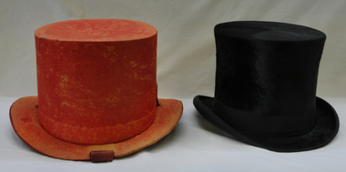
hat, Robertson & Moffat, late 19th -early 20th century
This item is representative of formal gentlemen's dress in the latter part of the 19th century/early 20th century.Man's top hat, black velour with ribbon around base. Brown leather and cream silk inner. With cover - bright red top hat keeper.Made expressly for Robertson & Moffat. Burke St East Melb. Inside - 7 1/8 YL/021/-hat costume-men headwear top-hat -
 Orbost & District Historical Society
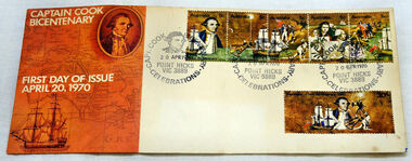
first day cover, Australia Post, April 1970
The Point Hicks cancel was used 8,269 times on the commemorative covers dated 20th April 1970. The first day cover commemorates the bicentenary of Cook's sighting of Point Hicks.When sailing along the coast of what is today southern Victoria, Cook recorded in his journal in April 1770 that he had named "The Southernmost Point of land we had in sight as Point Hicks, because Leiut Hicks, was the first who discoverd this land." This was the first European name recorded during that Endeavour voyage to be applied to a feature on the east coast of Australia. There is no longer a post office at Point Hicks and was possibly a temporary one used only for this issue.A first day issue envelope with stamps. Produced to commemorate the sighting of Point Hicks by Captain James Cook 0n 20 April 1770. It is a large cover with a strip of 5x 5c & a single 30c stamps. first-day-cover cook-james stamps philately point-hicks -
 Orbost & District Historical Society
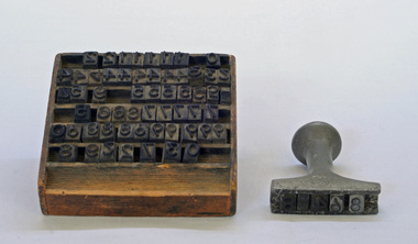
stamp holder and numbers, Victorian Government Railways, c. 1930s- 1980s
Used on the Orbost-Bairnsdale railway line which closed in 1987. The Bairnsdale-Orbost railway was opened in 1916 to serve the agricultural and timber industry. Because of the decline in traffic and heavy operating costs, the line was finally closed in August, 1987. Orbost Railway Station was opened on Monday 10 April 1916 as the terminus of the Orbost railway line, and closed in 1987. The station was located on the west side of the Snowy River despite the town of Orbost being on the east side of the river, in order to save on the costs of a bridge over the river, which at the time had highly variable levels This item is associated with the history of the Orbost-Bairnsdale railway line and therefore reflects the role that the rail line played in the social and economic history of Orbost.A stamp holder made of aluminium into which numbers and possibly letters can be inserted. Also a square shallow wooden box containing numbers which are used with the stamp. The numbers appear to be made of rubber.possibly V G R railway-history orbost-bairnsdale-railway -
 Orbost & District Historical Society
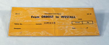
railways envelope, Victorian Railways, c. 1970s-1980s
Used at Orbost railway station for the consignment of goods/freight, in this case, timber to Westall. The Bairnsdale-Orbost railway was opened in 1916 to serve the agricultural and timber industry. Because of the decline in traffic and heavy operating costs, the line was finally closed in August, 1987. Orbost Railway Station was opened on Monday 10 April 1916 as the terminus of the Orbost railway line, and closed in 1987. The station was located on the west side of the Snowy River despite the town of Orbost being on the east side of the river, in order to save on the costs of a bridge over the river, which at the time had highly variable levels. This item is associated with the history of the Orbost-Bairnsdale railway line and therefore reflects the role that the rail line played in the social and economic history of Orbost.An unused brown/buff coloured goods/freight consignment envelope used by Victorian Railways, this one for timber from Orbost to Westall. 2498-78 VICTORIAN RAILWAYS From ORBOST to WESTALL Contents TIMBER railway-history orbost-bairnsdale-railway