Showing 6648 items
matching gullies
-
 Marysville & District Historical Society
Painting (Item) - Oil painting, Isaac Whitehead, A spring morning near Fernshaw 1880, 1880
A copy of an early oil painting of Fernshaw in Victoria.A copy of an early oil painting of Fernshaw in Victoria by Isaac Whitehead. Isaac Whitehead (1819–1881) was an Irish-Australian artist who worked in watercolour and pastel. He was also a picture framer and art promoter. It is believed that Isaaz Whitehead emigrated to Australia with his family in either 1853 or 1858. Isaac Whitehead died at his home 50 Punt Road, Prahran, Melbourne, on 21 April 1881. Isaac Whitehead had established himself as the foremost picture framer in Melbourne by 1860, known for his highly ornate frames with floral decorations. Among the clients of his framing business were Louis Buvelot, Nicholas Chevalier, and Eugene von Guérard. In his own paintings, he painted a number of scenes of the forests of Gippsland, Victoria. His work focused on the rich landscapes with trees and ferns, with a high degree of botanical detail. His work won him two medals and his work was posthumously exhibited at 1884 Victorian Jubilee Exhibition, the 1886 London Colonial and Indian Exhibition, and the 1888 Melbourne Centennial Intercolonial Exhibition. Fernshaw was a rural township 63 km northeast of Melbourne and 10 km northeast of Healesville. Situated on the Watts River, near where a log had fallen making a convenient crossing, Fernshaw was settled in the 1860s. It provided good country for orchards and berry growing. The location was at the foot of Blacks Spur, with Mounts Juliet and Mondah rising on either side, providing spectacular scenery. There were nearby fern gullies giving rise to the name – ‘shaw’ is old English for thicket or wood. By 1875 Fernshaw had a post office (1865), two hotels, a school (1871), and stores. It was famed for its beauty, attracting tourists. In 1886 the Melbourne and Metropolitan Board of Works began work on the Watts River water catchment scheme – later to become Maroondah – and the Board obtained approval for the catchment country to be reserved and kept free of settlement. This required the removal of the Fernshaw township, which was completed by about 1890.isaac whitehead, fernshaw, victoria, louis buvelot, nicholas chevalier, eugene von guerard, gippsland, victorian jubilee exhibition, london colonial and indian exhibition, melbourne centennial intercolonial exhibition, watts river, healesville, blacks spur, mount juliet, mount mondah -
 Marysville & District Historical Society
Photograph (Item) - Black and white photograph, Fred Kruger, Scene on the Watts River near Fernshaw, Unknown
A copy of a black and white photograph on the Watts River near Fernshaw in Victoria.A copy of a black and white photograph on the Watts River near Fernshaw in Victoria taken by Fred Kruger. Fred Kruger (born Johan Friedrich Carl Kruger, 18 April 1831 – 15 February 1888) was a German-born photographer noted for his early photography of landscape and indigenous peoples in Victoria, Australia. Fernshaw was a rural township 63 km northeast of Melbourne and 10 km northeast of Healesville. Situated on the Watts River, near where a log had fallen making a convenient crossing, Fernshaw was settled in the 1860s. It provided good country for orchards and berry growing. The location was at the foot of Blacks Spur, with Mounts Juliet and Mondah rising on either side, providing spectacular scenery. There were nearby fern gullies giving rise to the name – ‘shaw’ is old English for thicket or wood. By 1875 Fernshaw had a post office (1865), two hotels, a school (1871), and stores. It was famed for its beauty, attracting tourists. In 1886 the Melbourne and Metropolitan Board of Works began work on the Watts River water catchment scheme – later to become Maroondah – and the Board obtained approval for the catchment country to be reserved and kept free of settlement. This required the removal of the Fernshaw township, which was completed by about 1890.fernshaw, watts river, victoria, fred kruger, photograph -
 Marysville & District Historical Society
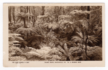
Postcard (item) - Black and white postcard, Rose Stereograph Company, Talbot Drive, Marysville, Vic. No. 2, Michael Dene, 1913-1967
A postcard in a series produced by the Rose Stereograph Company in Victoria, Australia as a souvenir of Marysville.A black and white photograph showing trees and tree ferns, taken along the Michaeldene Trail near Lady Talbot Drive in Marysville in Victoria. The Michaeldene Trail is a level two loop that leads to the Taggerty River Lookout and may be undertaken as either as a Short (2.7 km) Loop, or a Long (4.3 km) Loop - 30 minutes to one hour and a half. The attractive bushland linking the Steavenson and Taggerty Rivers allows walkers and cyclists to step back in time to Marysville’s historic logging past. Sections of this mostly flat circuit follow old tramline alignments, which in places reveal the original timber sleepers on which the big logs were transported to the nearby sawmill.The Taggerty River Lookout offers views over the Taggerty River. The Trestle Bridge was built to span a small gully and provide access to the timber on Red Hill. Lady Talbot Drive is a 24 kilometer scenic rainforest car journey which passes a number of walks and waterfalls in the Yarra Ranges National Park. Lady Talbot Drive is named after Lady Sarah Elizabeth, the wife of Sir Reginald Talbot, who was the Governor of Victoria from 25th April, 1904 to 6th July 1908. This postcard was produced by the Rose Stereograph Company as a souvenir of Marysville.REAL PHOTO POST CARD THE "ROSE"SERIES DE LUXE PRODUCED IN AUSTRALIA Published by "The Rose Stereographs" Armadale, Victoria.marysville, victoria, michael dene, michael dene track, p. 2307, walking track, rose series postcard, postcard, souvenir, lady talbot drive, sarah elizabeth talbot, sir reginald talbot -
 Marysville & District Historical Society
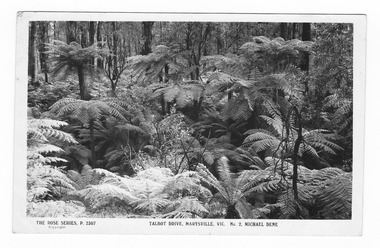
Postcard (item) - Black and white postcard, Rose Stereograph Company, Talbot Drive, Marysville, Vic. No. 2, Michael Dene, 1913-1967
A postcard in a series produced by the Rose Stereograph Company in Victoria, Australia as a souvenir of Marysville.A black and white photograph showing trees and tree ferns, taken along the Michaeldene Trail near Lady Talbot Drive in Marysville in Victoria. The Michaeldene Trail is a level two loop that leads to the Taggerty River Lookout and may be undertaken as either as a Short (2.7 km) Loop, or a Long (4.3 km) Loop - 30 minutes to one hour and a half. The attractive bushland linking the Steavenson and Taggerty Rivers allows walkers and cyclists to step back in time to Marysville’s historic logging past. Sections of this mostly flat circuit follow old tramline alignments, which in places reveal the original timber sleepers on which the big logs were transported to the nearby sawmill.The Taggerty River Lookout offers views over the Taggerty River. The Trestle Bridge was built to span a small gully and provide access to the timber on Red Hill. Lady Talbot Drive is a 24 kilometer scenic rainforest car journey which passes a number of walks and waterfalls in the Yarra Ranges National Park. Lady Talbot Drive is named after Lady Sarah Elizabeth, the wife of Sir Reginald Talbot, who was the Governor of Victoria from 25th April, 1904 to 6th July 1908.REAL PHOTO POST CARD THE "ROSE"SERIES DE LUXE PRODUCED IN AUSTRALIA Published by the Rose Stereographs Armadale, Victoria. Tomorrow is your Official day/ I believe. So Very Very many happy/ returns, & best of luck & good/ wishes from/ your May I rec'd this on/ 1st. (illegible)/ thought it a good snap of our ferns.marysville, victoria, michael dene, michael dene track, p. 2307, walking track, rose series postcard, postcard, souvenir, lady talbot drive, sarah elizabeth talbot, sir reginald talbot -
 Marysville & District Historical Society
Photograph (Item) - Black and white photograph, Nicholas John Caire, c1880-1884
A copy of an early black and white photograph of Murchison Street in Marysville in Victoria taken by Nicholas John Caire.A copy of an early black and white photograph of Murchison Street in Marysville in Victoria taken by Nicholas John Caire. Murchison Street was named for Roderick Impey Murchison who was one of the most distinguished geologists of the 19th century. His liberality and social position plus the pride he took in his science were of immense value in furthering the cause of learning in Britain. Nicholas John Caire was born in 1837 in Guernsey. He arrived in Adelaide about 1860 along with his parents who encouraged his early interest in photography. He opened a studio in Adelaide in 1867 after traveling extensively throughout the Gippsland taking photographs. After marrying in 1870 he moved to Talbot in Victoria until 1876 when he opened a studio in the Royal Arcade in Melbourne. After 1885 Nicholas John Caire gave up his city work and made his home in South Yarra and devoted the rest of his life to outdoor photography, specializing in the bush, the gullies, and the mountains of south-eastern Victoria. LES HARSANT/ HEALESVILLE Entrance to Marysville/ from Nicholas Caire photo - c.1880-84 See Pitkethly, N.J. Caire, Landscape Photographer Pithkethly, Rosanna, Vic. 1988; plate 17murchison street, marysville, victoria, nicholas john caire, roderick impey murchison, geology, geologist -
 Marysville & District Historical Society
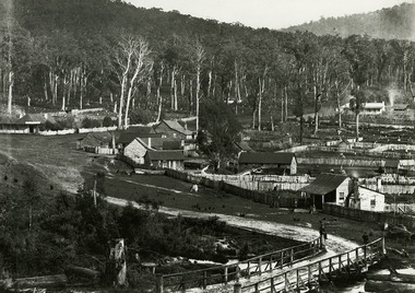
Photograph (Item) - Black and white photograph, Nicholas John Caire, c1900
A copy of an early black and white photograph of Marysville in Victoria taken by Nicholas John Caire.A copy of an early black and white photograph of Marysville in Victoria taken by Nicholas John Caire. N.J. Caire had a great love for the area in and surrounding Marysville and in the late 1800's took many photographs of Marysville and its surrounds. N.J. Caire was born in 1837 in Guernsey. He arrived in Adelaide about 1860 along with his parents who encouraged his early interest in photography. He opened a studio in Adelaide in 1867 after traveling extensively throughout the Gippsland taking photographs. After marrying in 1870 he moved to Talbot in Victoria until 1876 when he opened a studio in the Royal Arcade in Melbourne. After 1885 N.J. Caire gave up his city work and made his home in South Yarra and devoted the rest of his life to outdoor photography, specializing in the bush, the gullies and the mountains of south-eastern Victoria. Photography - Caire, N.J. Town of Marysville In: Victorian Views 1905 - Album 224. P.24 National Library of Australiamarysville, victoria, nicholas john caire -
 Marysville & District Historical Society
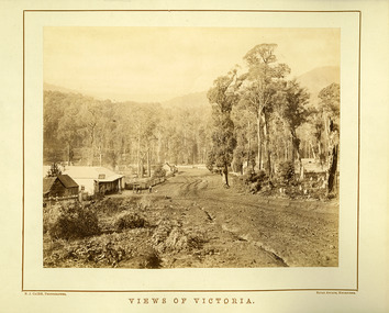
Photograph (Item) - Black and white photograph, Nicholas John Caire, Views of Victoria, Unknown
An early black and white photograph of the main road in Marysville in Victoria taken by Nicholas John Caire.An early black and white photograph of the main road in Marysville in Victoria showing the Keppels Australian Hotel which was built and opened by the Keppel Family in 1865. The Keppels Australian Hotel was the first hotel to be opened in Marysville. The Keppel Family were among Marysville's earliest pioneering families. This photograph was taken by Nicholas John Caire. N.J. Caire had a great love for the area in and surrounding Marysville and in the late 1800's took many photographs of Marysville and its surrounds. N.J. Caire was born in 1837 in Guernsey. He arrived in Adelaide about 1860 along with his parents who encouraged his early interest in photography. He opened a studio in Adelaide in 1867 after traveling extensively throughout the Gippsland taking photographs. After marrying in 1870 he moved to Talbot in Victoria until 1876 when he opened a studio in the Royal Arcade in Melbourne. After 1885 N.J. Caire gave up his city work and made his home in South Yarra and devoted the rest of his life to outdoor photography, specializing in the bush, the gullies and the mountains of south-eastern Victoria. N.J. CAIRE, PHOTOGRAPHER ROYAL ARCADE, MELBOURNEmarysville, victoria, keppels australian hotel, keppel family, nicholas john caire, photograph -
 Marysville & District Historical Society
Photograph (Item) - Black and white photograph, Nicholas John Caire, 1883
An early black and white photograph of the township of Marysville in Victoria.An early black and white photograph of the township of Marysville in Victoria. This photograph of Marysville was taken by Nicholas John Caire in 1883. Nicholas John Caire was born in 1837 in Guernsey. He arrived in Adelaide about 1860 along with his parents who encouraged his early interest in photography. He opened a studio in Adelaide in 1867 after traveling extensively throughout the Gippsland taking photographs. After marrying in 1870 he moved to Talbot in Victoria until 1876 when he opened a studio in the Royal Arcade in Melbourne. After 1885 Nicholas John Caire gave up his city work and made his home in South Yarra and devoted the rest of his life to outdoor photography, specializing in the bush, the gullies, and the mountains of south-eastern Victoria. nicholas john caire, marysville, victoria -
 Marysville & District Historical Society
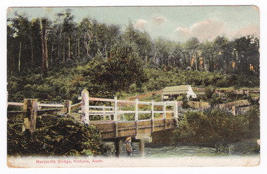
Postcard (Item) - Colour tinted postcard, Nicholas John Caire, Marysville Bridge, Victoria, Austr, 1878-1904
One of a series of postcards of photographs taken by socialite photographer Nicholas John Caire.One of a series of postcards of photographs taken by socialite photographer Nicholas John Caire. N.J. Caire had a great love for the area in and surrounding Marysville and in the late 1800's took many photographs of Marysville and its surrounds. N.J. Caire was born in 1837 in Guernsey. He arrived in Adelaide about 1860 along with his parents who encouraged his early interest in photography. He opened a studio in Adelaide in 1867 after traveling extensively throughout the Gippsland taking photographs. After marrying in 1870 he moved to Talbot in Victoria until 1876 when he opened a studio in the Royal Arcade in Melbourne. After 1885 N.J. Caire gave up his city work and made his home in South Yarra and devoted the rest of his life to outdoor photography, specializing in the bush, the gullies and the mountains of south-eastern Victoria.POST CARD This Space may be Used/ for Correspondence The Address Only to be/ Written Here. 88421 Dear Miss McNair./ We arrived home/ quite safely on Sat./ The children met/ us with Fran and/ Auntie Ethel at the/ Circular Quay. All/ were well and real/ glad to have us home/ again. We were so sorry/ we were too late/ for the train. We thought/ we saw Mr Mr McNair walking from/ the train. Love to ????/ Kisses for Ollie from A.M.G. Miss McNair/ Wattle Street/ Bendigo/ Victoriamarysville, victoria, nicholas john caire, bridge scene, 88421, postcard, souvenir -
 Marysville & District Historical Society
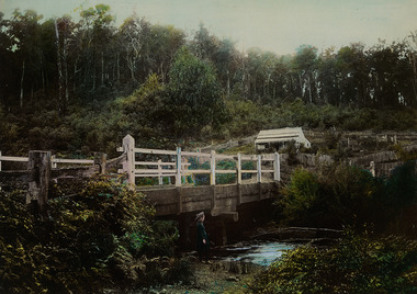
Photograph (Item) - Colour tinted photograph, 1878-1904
A copy of an early colour tinted photograph of a wooden bridge in Marysville in Victoria.A copy of an early colour tinted photograph of a wooden bridge in Marysville in Victoria. This photograph was taken by Nicholas John Caire between 1878 and 1904. Nicholas John Caire was born in 1837 in Guernsey. He arrived in Adelaide about 1860 along with his parents who encouraged his early interest in photography. He opened a studio in Adelaide in 1867 after traveling extensively throughout the Gippsland taking photographs. After marrying in 1870 he moved to Talbot in Victoria until 1876 when he opened a studio in the Royal Arcade in Melbourne. After 1885 Nicholas John Caire gave up his city work and made his home in South Yarra and devoted the rest of his life to outdoor photography, specializing in the bush, the gullies, and the mountains of south-eastern Victoria. nicholas john caire, marysville, victoria -
 Federation University Historical Collection
Photograph - Black and White Photograph, Gold Nugget From White Horse Gully Bendigo, 16/04/1853
Pphotograph of an illustration from teh Illustrated London News 16 April 1853.white horse gully, bendigo, gold nugget -
Ringwood and District Historical Society
Legal record - Conditions of Sale (C.E.Carter), Lot 18 - Bayswater, Lot 5 - Fern Tree Gully, Lot 13 - Bayswater, Lot 1 - Ringwood, Lot 26 - Ringwood, Various Vendors and C.E.Carter, 1941
Particulars and Conditions of Sale of Property , from various Vendors to C.E.Carter. -
 Greensborough Historical Society
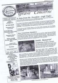
Newsletter, Queenstown Cemetery, Grave concerns. Issue 1 October 2015, 01/10/2015
Newsletter about Queenstown Cemetery, its history and maintenanceBlack and white newsletter, stapledqueenstown cenetery, smith's gully -
 Emerald Museum & Nobelius Heritage Park
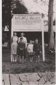
Photograph Stillwell Family, 1953
Entrance to Stillwell Valley (at edge of Emerald Lake). Graham and Helen Stillwell (now Swaine) with Aunt Gwen Stillwell and friends. Grandfather, Bertie Stillwell opened Emerald Lake in 1941.Bertie Stillwell was a Councillor with Fern Tree Gully Council. Stillwell's Deviation is located off Avons Rd, Avonsleigh.Black & White photograph. stillwell-valley; bertie-stillwell; emerald-lake-park; helen-swaine; -
 Eltham District Historical Society Inc
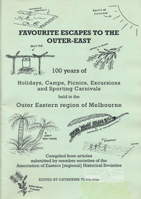
Book, Association of Eastern Historical Societies, Favourite Escapes to the Outer-East edited by Catherine Turnbull, 2002
Compiled from articles submitted by member societies of the Association of Eastern [regional] Historical Societies58 p. : ill. ; 30 cm.ISBN 0957788088lillydate, fern tree gully, yarra flats, gulf station, smiths gully, doncaster, narre warren, gembrook, eltham, blackburn lake, surrey hills, warrandyte, bayswater, yarra glen, queenstown, marysville, waverley, wonga park, bend of islands, dandenongs -
 Eltham District Historical Society Inc
Photograph, Cant house and farm, Salters Rush
Photocopy of image of house and farm of William and Jessie Cant, Salters Rush, Queenstown. The orchard grew cherries, apples, plums, pears, quinces and berries - raspberry, blackberry, gooseberry, red currants and black currants. Also vegetables and flowers. All cultivation done by hand. (Chancellor photograph)houses, farming, orchards, salters rush, queenstown, smiths gully, william cant, jessie cant -
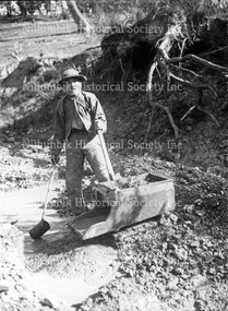 Nillumbik Historical Society Incorporated
Photograph - Black & white photograph, Johnny working in Watery Gully
Black & white photograph -
 Nillumbik Shire Council
Yvonne BIRCH, Landscape, Smiths Gully
-
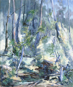
 Gippsland Art Gallery
Painting, Piggott, Owen, Gully Trees, 1979-80
Donated from the estate of the artist, 2016Acrylic, Canvasgippsland, artwork, permanent collection -
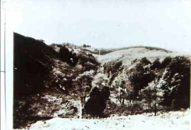 Inverloch Historical Society
000674 - Photograph - 1929 - Leongatha - Gully from Reservoir - from J Fincher
-
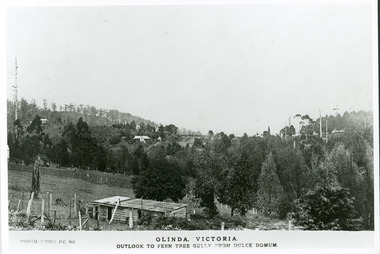 Mt Dandenong & District Historical Society Inc.
Photograph, Olinda, Victoria. Outlook to Ferntree Gully from Dulce Domun
Rose Series Postcard number 965Copy of Photo Series postcard #965 with view looking west to Mt Dandenong Road and Ridge Road. Looking across to where the Log Cabin (Kellys) would now be.mount dandenong, dulce domum, photo series -
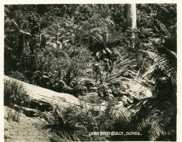 Mt Dandenong & District Historical Society Inc.
Photograph, Lyre Bird Gully, Olinda, c1930s
Number 4 in commercial series.Small photograph, number 4 in Olinda series, showing ferns and fallen trees in natural bush scene.olinda, lyre bird gully, lyre bird, bush -
 Brimbank City Council
Flag, Green Gully Soccer Club
-
Federation University Historical Collection
Book, Historic Sites Survey: North Central Study Area, 1979
The North Central Study Area included the Shires of Avoca, Bet Bet, east Loddon, Goulburn, Untly, Kara Kara, Korong, Maldon, Marong, Metcalfe, McIvor, Newstead, Strathfieldsaye, Stawell, Talbot, Clunes, Tullaroop and Waranga. 153 page book with white plastic binding. It is an historic sites survey for the North Central Study Area commissioned by the Land Conservation Council, the Ministry for COnservation and the Australian Heritage Commission. castlemaine, mount alexander goldfield, maldon, percydale, warrenmang, moliagul, tarnagulla, stuart mill, the whipstick, whroo, rushworth, graytown ironbark forest, st arnoaud, new bendigo, landsborough, inglewood, kurting, wedderburn, wehla, kooroora, langham flat, mcintyre, rheola, diamond hill, fosterville, coliban water works, green gully, newstead, muckleford forest, costerfield, graytown, bailieston, waranga irrigaiton system, eucalyptus distillery, mia mia bridge, korokubeal township researce, concegella slate quarry, chewton, fryerstown, kingower, timor, talbot, majorca, carisbroook, clunes, st arnaud, taradale, icomos, dunolly, limestone, castlemaine slate quarry, harcourt granite, taradale railway viaduct, loddon united waterworks trust, gouldburn weir, carisbrook lock-up, history of tree planting in streets, history of public reserves, r.u. nicholls nurseryman, thomas lang, francis moss, ballarat botanical gardens, ballarat school of mines botanical gardens, lake wendouree, victoria park, ballarat, muont holled smith, ballaarat old cemetery planting, eastern oval, ballarat east botanical gardens, ballarat east town hall gardens, eureka stockade reserve, ballarat observatory plantings, yarrowee creek plantings, yarrowee bluestone channels, ballarat woollen mill, band and albion mullock heap, black hill plantings, yarrowee creek channels, canadian creek channel, specimen vale channel, poverty point reserve, union jack reserve buninyong, imperial mine, buninyong, victoria street plantings, bridge mall, sturt street gardens, ballarat avenue of honour plantings, white flat oval plantings, camp street, elms, burnt creek -
Federation University Historical Collection
Newspaper, ANZAC Centenary newspaper features, 2015, 25/04/2015
The Centenary of the ANZAC landing of Gallipoli was marked in 2015. .1) Herald Sun Gallipoli 100-year Anniversary - The Legend Begins. Includes information on Gallipoli, Gallipoli landing, Lemnos, VC Winners, William Dunstan, Bigali, The Nek, Indigenous soldiers, Lone Pine, Gallipoli Retreat Images include: Gallipoli, William Birdwood, Harold Walker, Winston Churchill, Ian Hamilton, John Fisher, William Throsby Bridges Otto Linden von Sanders, Herbert Asquith, Sinclair MacLagan, Mehit Sefik, Mastafa Kermal, nurses on Lemnos, Alexander Burton, Bigali, Turkey, Keith Murdoch, Charles Bean, Joe Stratford, Frank Loud, Thomas Ford, Leslie Boyce, Raymond Brownell, Alfred Lovett, Leonard Lovett, Frederick Amos Lovett, Herbert Stahle Lovett, Cyril Brudenell White, Minyip .2) ANZAC Day 2015 Supplement from The Age. The supplement includes information on Australia's compulsory cadet training, Wireless telegraphists, horses .3) The Age ANZAC centernary Galipoli Tribute, 2015. Eight page broad sheet with amazing stories from the front line. Includes a listing of all those who lost their lives on the Gallipoli Peninsula, timeline of the Gallipoli landing, information on Douglas Barrett-Lennard, William Throsby Bridges, Alan Dudley Henderson, James Charles Martin, Arthur Harold Jopp, John Simpson Kirkpatrick, Cecil Anthony McAnulty, Laurence W. Street, Alfred Shout, Joseph Stratford, Alexander Stewart Burton, Alfred Hearpsgallipoli, anzac centenary, gallipoli landing, walker's ridge, pope's hill, quinn's post, lone pine, pine ridge, shrapnel gully, the sphinx, maclaurin's hill, monash valley, plugge's plateau, dardenells, keith murdoch, charles bean, cadets, compulsory cadet training -
Federation University Historical Collection
Reports, Unidentified Mammal Report, 1970-1990
The folder or correspondence is the result of a Freedom of Information request made to the Department of of Conservation, Forests and Lands in 2011. The folder was collected for research being conducted by David Waldron.Folder of reports relating to "Big Cats", Thylacines, and other large predators sightings australian mythical animals collection, david waldron, thylacine, sassafras, peter monhorst, jodie hoey, kelvin smith, traralgon south, gormondale, bridgewater, g. mcclure, whorouly, albury, jim walker, andrea westcott, john dawson, nicole walsh, grampians, eddy scott, talbot, lancefield, kalorama, inglewood, gavin cerini, dereel, rosemary fernandez, brian walters, alexandra, unidentified mammel, romsey, bill butterworth, flowerdale, bob hoare, trafalgar, lyn demopolis, broadford, green gully, ian weir, noel pascoe, bruce carter, mount stirling, andrea cooper, stawell, yvonne shepherd, red hills, halls gap, jill reid, puma, w.r.c. hill, caelli -
Federation University Historical Collection
Book, Maldon Historic Reserve Management Plan, 1989
This book was prepared by the Royal Botanic Gardens, Mebourne Soft covered report of 83 pages, including 10 folded leaves of plates , and 11 maps (some coloured). maldon, geology, flora, vermin, parkin's reef, derby hill, beehive reef, long gully, union hill, mount tarrengower, eaglehawk gully, porcupine flat, neggetty range, peg leg gully, sandy creek, smiths creek, landscape -
 Eltham District Historical Society Inc
Photograph, Research Gully Road
Source: Mrs. E.R. Reynolds, Thompson Crescent, ResearchThis photo forms part of a collection of photographs gathered by the Shire of Eltham for their centenary project book,"Pioneers and Painters: 100 years of the Shire of Eltham" by Alan Marshall (1971). The collection of over 500 images is held in partnership between Eltham District Historical Society and Yarra Plenty Regional Library (Eltham Library) and is now formally known as the 'The Shire of Eltham Pioneers Photograph Collection.' It is significant in being the first community sourced collection representing the places and people of the Shire's first one hundred years.Digital imagesepp, shire of eltham pioneers photograph collection, research (vic.), research gully road -
 Eltham District Historical Society Inc
Photograph, Research. Showing top part of present day (1970) Ingrams Road on left. Then research Gully Road
Source: Mrs. E.R. Reynolds, Thompson Crescent, ResearchThis photo forms part of a collection of photographs gathered by the Shire of Eltham for their centenary project book,"Pioneers and Painters: 100 years of the Shire of Eltham" by Alan Marshall (1971). The collection of over 500 images is held in partnership between Eltham District Historical Society and Yarra Plenty Regional Library (Eltham Library) and is now formally known as the 'The Shire of Eltham Pioneers Photograph Collection.' It is significant in being the first community sourced collection representing the places and people of the Shire's first one hundred years.Digital imagesepp, shire of eltham pioneers photograph collection, research (vic.) -
 Eltham District Historical Society Inc
Document - Property Binder, 1572 Main Road, Research
Typed sheets (2 pages): History of Research State School No. 2959, Principal F P Sheehan, historian M Allwood,main road, property, houses, shops, businesses, research (vic.), research state school no. 2959, caledonian gold field, swiper's gully, wallaby town, research gully, discovery gold plenty ranges, fountain of friendship hotel, ray morris, alice russell, norma family, bettison family, reynolds family, william west, joseph m makey, henry james cole, mary jane rodda, florissa milton, f p sheehan, m allwood, research hotel