Showing 2482 items
matching 1940s.
-
 Eltham District Historical Society Inc
Photograph, Liz Pidgeon, Heritage Excursion; East of Eltham, 6 Sep 2014, 20 May 2017
Newsletter No. 218, September 2014 September Excursion - East of Eltham Walk In Newsletter No. 197, March 2011, there was a brief history of Crown Allotment 15 Section 5 Parish of Nillumbik (CA 15) a parcel of land of a quarter of a square mile extending from Eucalyptus Road to Reynolds Road at the eastern extremity of Eltham. From the 1940s it was known as Stokes orchard. In later years it has been subdivided for residential purposes but leaving significant areas as power line and water supply reserves and bushland reserves that are habitat for the threatened For our excursion on 6th September we intend to walk through CA 15 to a bushland reserve east of Reynolds Road. The walk will traverse the boundary between suburban Eltham and the non-urban areas to the south and east. This is a pleasant walk through residential areas and bushland. Along the way we will discuss the early and more recent history of CA 15 as well as local natural history and geology. This walk is about 3.5 km in length and will take 2 to 2.5 hours. It will start at 2pm at the corner of Eucalyptus Road, Pitt Street and Nyora Road.Born Digitaleltham east, eltham district historical society, heritage excursion, activities, nyora road, reynolds road, gum tree road reserve, diosma road, stokes orchard, eucalyptus road -
 City of Moorabbin Historical Society (Operating the Box Cottage Museum)
Photograph, Black & White x4 Maypole Dance Moorabbin State School 1922, 1922
In October 1872, State School 1111 Box Rise opened on the corner of Worthing Road and Dane Road. In order for this school to open, School No 442, a Wesleyan School, on the corner of Wickham Road and Chapel Lane, had to agree to close to meet pupil number requirements. Charles Sadgrove was head teacher of the new State School when it opened on October 1st 1872 and he remained until 1878. The school was renamed South Brighton in 1887 to accord with the nearby railway station which opened around that time. The main part of the present building dates from 1890. By the early 1900s the school had been extended to the north. . The school contains a plaque for Harry G Hawker, one of the pioneers of aviation, who attended the school in the closing years of the nineteenth century. The school was renamed Moorabbin in 1909.During the 1940s and 1950s population in the area surged and school enrolments peaked to over 800 under head teacher CS Lansell. Enrollments decreased to 470 in 1969. By the 1990s however, enrollments began to increase again. ( G Whitehead KCC Historian) Since 1890 Moorabbin Primary School No.1111 has been socially significant at a local level providing education for the families of the early settlers in Moorabbin ( South Brighton) Black & White photographs x 4 of pupils at Moorabbin State School Maypole Dancing c1922keys robert, marriott charles, gregg barriecity of moorabbin, county of bourke, moorabbin roads board, parish of moorabbin, shire of moorabbin, henry dendy's special survey 1841, were j.b.; bent thomas, o'shannassy john, king richard, charman stephen, highett william, ormond francis, maynard dennis, methodist church wickham road, box rise state school no.1111, methodist chapel cheltenham, education, early settlers -
 Melbourne Legacy
Photograph, Sir Edward Dunlop, 1986
A large poster of Sir Ernest Edward "Weary" Dunlop, AC, CMG, OBE (12 July 1907 – 2 July 1993). He was an Australian surgeon who was renowned for his leadership while being held prisoner by the Japanese during World War II. He was involved with Legacy on numerous occasions - including a dinner with Clive James in 1993.When he passed away in 1993 there was a tribute in the Answer. Unknown when the photo was taken - perhaps the 1940s (Note; the colour patch on the upper arm.) Photo has possibly been taken on Anzac Day. (Note; Anzac Day badge on left lapel of battle dress jacket and sprig of rosemary rising above decorations pinned on right chest of battle dress jacket.). The Technical Bookshop were tenants in the shopfront premises of Legacy House for many years. This could have been advertising material for Weary Dunlops War Diaries which were published by Penguin in 1986, presumably the poster was given to Legacy in December 1990 when no longer required in store.This shows the Technical Bookshop had a good relationship with Legacy and understood the connection between Weary Dunlop and Legacy.Coloured photo of Sir (Ernest) Edward "Weary" Dunlop that was used to promote a book about him. Reverse side, a Christmas message to Legacy, written in blue texta. Penguin publishing company logo appears in the bottom left hand corner.Reverse side, handwritten in blue texta "To Legacy. Merry Christmas love Technical Bookshop xxx. 1990"dunlop, portrait -
 Kew Historical Society Inc
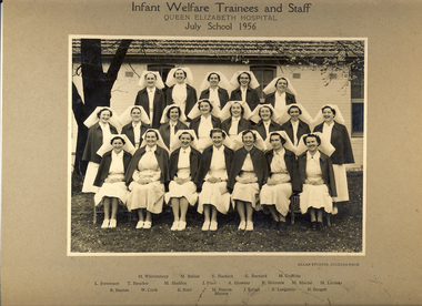
Photograph, Infant Welfare Trainees and Staff, Queen Elizabeth Hospital, 1956
Carlton Refuge/Carlton Home was established in 1857 in Madeline Street, Carlton (relocating in 1890 to Keppel Street, Carlton). The Carlton Home provided maternity care for married and unmarried mothers, and residential care for infants and toddlers unable to be at home with their mother. It also operated a day-care centre for children. Most of the residents were mothers or children on private placements. The Children's Welfare Department used the Carlton Home as a maternity home for wards, a foster home for infant wards, and for children requiring placements under the infant life protection provisions of the Children's Welfare Act. By the late 1940s, the home was in a bad state of repair and it closed in 1949. In 1951, the facility reopened as the Queen Elizabeth Maternal and Child Health Centre that also operated as an Infant Welfare and Mothercraft Training School. The Centre provided after-care for nursing mothers and babies transferring from maternity hospitals, and specialised care for babies referred by private practitioners and the Social Welfare Department – babies who were premature, frail or had feeding or similar problems. (Source: DHHS)The photograph is a valuable primary resource relating to training for maternal and infant welfare centres in Kew, Victoria. It has a strong provenance through inscriptions linking it to the Denmark Street Maternal and Child Health Centre.Photograph, mounted on card of Infant Welfare Trainees and Staff, Queen Elizabeth Hospital, 1956. The photograph lists the names of the individuals below the photograph. They include: Back Row {L-R] M Whittenbury, M Bolton, E Haebich, G Barnard, M Griffiths / Middle Row [L-R] L Stevenson, T Boucher, M Madden, J Price, A Glowrey, R Helmore, M Murfet, M Lindsay / Front Row [L-R] R Buxton, W Crick, G Stott, M Buxton Matron, J Keogh, B Longmuir, E Borgelt.Obverse: Infant Welfare Trainees and Staff, Queen Elizabeth Hospital, July School 1956 Reverse: "Presented to Kew Historical Soc by Dr Darbyshire following a 50 year birthday display at the Denmark Street Maternal and Child Health Centre [Kew] in May 1980. [Illegible]."denmark street maternal and child health centre, baby health centres --- kew (vic), queen elizabeth hospital, infant welfare -
 Melbourne Legacy
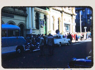
Slide, Legacy House in Market Street, 1957
A slide image of the old Legacy House in Market Street from 1957. It shows children and people gathered to go on an outing to the sea known for many years as Operation Float. Legacy rented the Market St premises for many years. A small 'Legacy House' sign can just be seen between the bus and the sign post. It was part of the Western Market complex that was demolished and redeveloped in the early 1960s. Legacy held meeting and the girls classes on the second floor of the building but it was barely fit for purpose. In the 1940s a generous donation by an anonymous donor meant Legacy could purchase a building at 342 Swanston St, but due to several factors were never able to inhabit it. Finally it was sold in 1954 and Junior Legacy Melbourne purchased 289-299 Swanston Street Melbourne (previously called Red Cross House) in 1956 from the Commonwealth Government. As part of the conditions of the donation it was named in memory of David H Dureau. Renovations were needed to the 289-299 Swanston St building so this slide shows that Legacy were still in the Market St building in 1957 while they occurred. A record of the Market Street building that Legacy occupied for many years until 1956-7.Colour slide of Legacy House in Market Street from 1957.Slides has 'Que for Operation Float looking up Market St'. It is numbered '14' by the manufacturer.properties, market st, streetscape