Showing 2588 items matching " yarra park"
-
 Kew Historical Society Inc
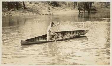
Photograph - Victorian Canoe Club, Racer completed (Retriever), 1920-30
... Yarra...Burke Road...Mornington...Studley park...Park and Kew where the canoes were used. The subject of this photograph is identified as 'Racer completed (Retriever)' where the completed canoe is trialled on the Yarra River....Park and Kew where the canoes were used. The subject of this photograph is identified as 'Racer completed (Retriever)' where the completed canoe is trialled on the Yarra River. ...Canoeing on the River Yarra at Melbourne was an important and widespread recreational pursuit for Melbournians, especially in the first half of the twentieth century. The Victorian Canoe Club was formed in 1912 at a meeting in Melbourne and its first committee elected in the same year. Records indicate that the Club continued into at least the 1950s .The album has historic and social significance as a record of recreational activities (as well as canoe making) in the early years of the twentieth century. It has local significance as the site of the headquarters of the Club was in Studley park. A number of photographs in the album provide vistas of Kew on the Yarra that are otherwise unavailable.One of 24 labelled photos in part album, originating from the Victorian Canoe Club, which had its headquarters in Studley Park, Kew. The album includes a photographic record of canoe construction and also locations in Studley Park and Kew where the canoes were used. The subject of this photograph is identified as 'Racer completed (Retriever)' where the completed canoe is trialled on the Yarra River."Racer completed (Retriever)"victorian canoe club, canoe making, river yarra, burke road, mornington, studley park, kew, steaming gear, canoe construction -
 Kew Historical Society Inc
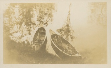
Photograph - Victorian Canoe Club, Nagha & Dunapna completed completed, 1920-30
... Yarra...Burke Road...Mornington...Studley park...Park and Kew where the canoes were used. The subject of this photograph is identified as 'Nagha & Dunapna completed' with an overhead view of two named canoes on the banks of the Yarra River....Park and Kew where the canoes were used. The subject of this photograph is identified as 'Nagha & Dunapna completed' with an overhead view of two named canoes on the banks of the Yarra River. ...Canoeing on the River Yarra at Melbourne was an important and widespread recreational pursuit for Melbournians, especially in the first half of the twentieth century. The Victorian Canoe Club was formed in 1912 at a meeting in Melbourne and its first committee elected in the same year. Records indicate that the Club continued into at least the 1950s .The album has historic and social significance as a record of recreational activities (as well as canoe making) in the early years of the twentieth century. It has local significance as the site of the headquarters of the Club was in Studley park. A number of photographs in the album provide vistas of Kew on the Yarra that are otherwise unavailable.One of 24 labelled photos in part album, originating from the Victorian Canoe Club, which had its headquarters in Studley Park, Kew. The album includes a photographic record of canoe construction and also locations in Studley Park and Kew where the canoes were used. The subject of this photograph is identified as 'Nagha & Dunapna completed' with an overhead view of two named canoes on the banks of the Yarra River."Nagha & Dunapna completed"victorian canoe club, canoe making, river yarra, burke road, mornington, studley park, kew, steaming gear, canoe construction -
 Kew Historical Society Inc
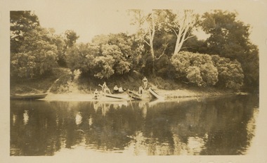
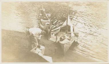
Photograph - Victorian Canoe Club, Camp site near Burke Road, 1920-30
... Yarra canoe clubs canoeing Recreation -- canoeing Burke Road -- Kew (Vic.) Kew "Camp site near Bourke Rd" One of 24 labelled photos in part album, originating from the Victorian Canoe Club, which had its headquarters in Studley Park, Kew. ...Canoeing on the River Yarra at Melbourne was an important and widespread recreational pursuit for Melbournians, especially in the first half of the twentieth century. The Victorian Canoe Club was formed in 1912 at a meeting in Melbourne and its first committee elected in the same year. Records indicate that the Club continued into at least the 1950s .The album has historic and social significance as a record of recreational activities (as well as canoe making) in the early years of the twentieth century. It has local significance as the site of the headquarters of the Club was in Studley Park. A number of photographs in the album provide vistas of Kew on the Yarra that are otherwise unavailable.One of 24 labelled photos in part album, originating from the Victorian Canoe Club, which had its headquarters in Studley Park, Kew. The album includes a photographic record of canoe construction and also locations in Studley Park and Kew where the canoes were used. The subject of this photograph is identified as 'Camp site near Burke Road' with four canoes on the river bank with members beside them. "Camp site near Bourke Rd"victorian canoe club, river yarra, canoe clubs, canoeing, recreation -- canoeing, burke road -- kew (vic.), kew -
 Kew Historical Society Inc
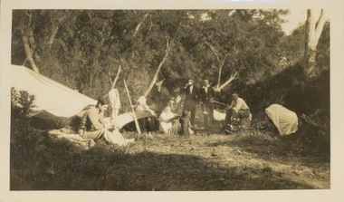
Photograph - Victorian Canoe Club, Camp site near Burke Road, 1920-30
... Yarra canoe clubs canoeing Recreation -- canoeing Burke Road -- Kew (Vic.) Kew "Camp site near Bourke Rd" One of 24 labelled photos in part album, originating from the Victorian Canoe Club, which had its headquarters in Studley Park, Kew. ...Canoeing on the River Yarra at Melbourne was an important and widespread recreational pursuit for Melbournians, especially in the first half of the twentieth century. The Victorian Canoe Club was formed in 1912 at a meeting in Melbourne and its first committee elected in the same year. Records indicate that the Club continued into at least the 1950s .The album has historic and social significance as a record of recreational activities (as well as canoe making) in the early years of the twentieth century. It has local significance as the site of the headquarters of the Club was in Studley Park. A number of photographs in the album provide vistas of Kew on the Yarra that are otherwise unavailable.One of 24 labelled photos in part album, originating from the Victorian Canoe Club, which had its headquarters in Studley Park, Kew. The album includes a photographic record of canoe construction and also locations in Studley Park and Kew where the canoes were used. The subject of this photograph is identified as 'Camp site near Burke Road' with members around a fire at a campsite."Camp site near Bourke Rd"victorian canoe club, river yarra, canoe clubs, canoeing, recreation -- canoeing, burke road -- kew (vic.), kew -
 Kew Historical Society Inc
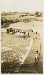
Photograph - Victorian Canoe Club, Dight's Falls, Studley Park, 1920-30
... Dight's Falls -- Yarra River "Dyghts Falls, Studley Park" One of 24 labelled photos in part album, originating from the Victorian Canoe Club, which had its headquarters in Studley Park, Kew. ...Canoeing on the River Yarra at Melbourne was an important and widespread recreational pursuit for Melbournians, especially in the first half of the twentieth century. The Victorian Canoe Club was formed in 1912 at a meeting in Melbourne and its first committee elected in the same year. Records indicate that the Club continued into at least the 1950s .The album has historic and social significance as a record of recreational activities (as well as canoe making) in the early years of the twentieth century. It has local significance as the site of the headquarters of the Club was in Studley Park. A number of photographs in the album provide vistas of Kew on the Yarra that are otherwise unavailable.One of 24 labelled photos in part album, originating from the Victorian Canoe Club, which had its headquarters in Studley Park, Kew. The album includes a photographic record of canoe construction and also locations in Studley Park and Kew where the canoes were used. The subject of this photograph is identified as 'Dight's Falls, Studley Park'.The view is from above and shows an early trestle bridge across the Falls on which people, possibly members of the Club, are walking or standing. The point of view would appear to be looking up river towards Fairfield."Dyghts Falls, Studley Park"victorian canoe club, river yarra, burke road -- kew (vic.), dight's falls -- fairfield (vic.), dight's falls -- kew (vic.), dight's falls -- yarra river -
 Kew Historical Society Inc
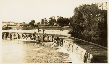
Photograph - Victorian Canoe Club, Dight's Falls, Studley Park, 1920-30
... Dight's Falls -- Yarra River "Dyghts Falls, Studley Park" One of 24 labelled photos in part album, originating from the Victorian Canoe Club, which had its headquarters in Studley Park, Kew. ...Canoeing on the River Yarra at Melbourne was an important and widespread recreational pursuit for Melbournians, especially in the first half of the twentieth century. The Victorian Canoe Club was formed in 1912 at a meeting in Melbourne and its first committee elected in the same year. Records indicate that the Club continued into at least the 1950s .The album has historic and social significance as a record of recreational activities (as well as canoe making) in the early years of the twentieth century. It has local significance as the site of the headquarters of the Club was in Studley Park. A number of photographs in the album provide vistas of Kew on the Yarra that are otherwise unavailable.One of 24 labelled photos in part album, originating from the Victorian Canoe Club, which had its headquarters in Studley Park, Kew. The album includes a photographic record of canoe construction and also locations in Studley Park and Kew where the canoes were used. The subject of this photograph is identified as 'Dight's Falls, Studley Park'.The view shows an early trestle bridge across the Falls on which people, possibly members of the Club, are standing. The point of view would appear to be looking up river towards Fairfield."Dyghts Falls, Studley Park"victorian canoe club, river yarra, burke road -- kew (vic.), dight's falls -- fairfield (vic.), dight's falls -- kew (vic.), dight's falls -- yarra river -
 Kew Historical Society Inc
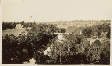
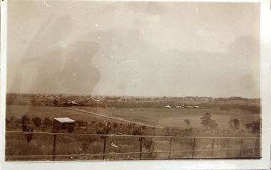
Photograph - Victorian Canoe Club, V.C.C. site, Studley Park, 1920-30
... Yarra Bend Asylum...Suspension bridge -- Kew...Kane's Bridge...Studley park...The subject of this photograph is identified as 'V.C.C. site, Studley Park'.The panoramic view shows a number of important landmarks during this period. On the left of the photograph is one of the remaining buildings of the Yarra Bend Asylum. ...The subject of this photograph is identified as 'V.C.C. site, Studley Park'.The panoramic view shows a number of important landmarks during this period. On the left of the photograph is one of the remaining buildings of the Yarra Bend Asylum. ...Canoeing on the River Yarra at Melbourne was an important and widespread recreational pursuit for Melbournians, especially in the first half of the twentieth century. The Victorian Canoe Club was formed in 1912 at a meeting in Melbourne and its first committee elected in the same year. Records indicate that the Club continued into at least the 1950s .The album has historic and social significance as a record of recreational activities (as well as canoe making) in the early years of the twentieth century. It has local significance as the site of the headquarters of the Club was in Studley Park. A number of photographs in the album provide vistas of Kew on the Yarra that are otherwise unavailable.One of 24 labelled photos in part album, originating from the Victorian Canoe Club, which had its headquarters in Studley Park, Kew. The album includes a photographic record of canoe construction and also locations in Studley Park and Kew where the canoes were used. The subject of this photograph is identified as 'V.C.C. site, Studley Park'.The panoramic view shows a number of important landmarks during this period. On the left of the photograph is one of the remaining buildings of the Yarra Bend Asylum. Stretching across the river is a suspension bridge on the site of the present Kane's Bridge. The reference to the V.C.C. site is unclear within the context of the photo which appears to be taken from the vicinity of the Johnston Street Bridge."V.C.C. site, Studley Park"victorian canoe club, river yarra, canoe clubs, yarra bend asylum, suspension bridge -- kew, kane's bridge, studley park -
 Kew Historical Society Inc
Photograph - Victorian Canoe Club, Y.M.C.A. Camp, Mornington, 1920-30
... Yarra at Melbourne was an important and widespread recreational pursuit for Melbournians, especially in the first half of the twentieth century. The Victorian Canoe Club was formed in 1912 at a meeting in Melbourne and its first committee elected in the same year. Records indicate that the Club continued into at least the 1950s . The album has historic and social significance as a record of recreational activities (as well as canoe making) in the early years of the twentieth century. It has local significance as the site of the headquarters of the Club was in Studley Park ...Canoeing on the River Yarra at Melbourne was an important and widespread recreational pursuit for Melbournians, especially in the first half of the twentieth century. The Victorian Canoe Club was formed in 1912 at a meeting in Melbourne and its first committee elected in the same year. Records indicate that the Club continued into at least the 1950s .The album has historic and social significance as a record of recreational activities (as well as canoe making) in the early years of the twentieth century. It has local significance as the site of the headquarters of the Club was in Studley Park. A number of photographs in the album provide vistas of Kew on the Yarra that are otherwise unavailable.One of 24 labelled photos in part album, originating from the Victorian Canoe Club, which had its headquarters in Studley Park, Kew. The album includes a photographic record of canoe construction and also locations in Studley Park and Kew where the canoes were used. The subject of this photograph is identified as 'Y.M.C.A. Camp, Mornington' at which members of the club presumably were staying. If it is Camp Manyung, that would date the photo to at least 1930, when the camp was established."Y.M.C.A. Camp, Mornington"victorian canoe club, canoe clubs, ymca camps, ymca camp -- mornington (vic.) -
 Kew Historical Society Inc
Album - Victorian Canoe Club : Album 2, 1920-30
... Yarra...Burke Road...Mornington...Studley park...Descriptive titles in the album include (sometimes referring to two photos): Steaming gear / Mould for racer / Ribs bent on mould / Planking [3] / Planking racer / Planking Nagha / Planking completed / Off mould / Built-up ends and deck frames / Racer completed (Retriever) / Nagha & Dnapna completed / V.C.C. Studley Park / On the Yarra / Through the rapids / Yarra near Bourke [sic] Rd [2] / Camp site near Bourke [sic] Rd / Dyghts [sic] Falls, Studley Park [2] / V.C.C. site, Studley Park / Y.M.C.A. ...Descriptive titles in the album include (sometimes referring to two photos): Steaming gear / Mould for racer / Ribs bent on mould / Planking [3] / Planking racer / Planking Nagha / Planking completed / Off mould / Built-up ends and deck frames / Racer completed (Retriever) / Nagha & Dnapna completed / V.C.C. Studley Park / On the Yarra / Through the rapids / Yarra near Bourke [sic] Rd [2] / Camp site near Bourke [sic] Rd / Dyghts [sic] Falls, Studley Park [2] / V.C.C. site, Studley Park / Y.M.C.A. ...Canoeing on the River Yarra at Melbourne was an important and widespread recreational pursuit for Melbournians, especially in the first half of the twentieth century. The Victorian Canoe Club was formed in 1912 at a meeting in Melbourne and its first committee elected in the same year. Records indicate that the Club continued into at least the 1950s .The album has historic and social significance as a record of recreational activities (as well as canoe making) in the early years of the twentieth century. It has local significance as the site of the headquarters of the Club was in Studley park. A number of photographs in the album provide vistas of Kew on the Yarra that are otherwise unavailable.24 labelled photos in part album, originating from the Victorian Canoe Club, which had its headquarters in Studley Park, Kew. The album includes a photographic record of canoe construction and also locations in Studley Park and Kew where the canoes were used. Descriptive titles in the album include (sometimes referring to two photos): Steaming gear / Mould for racer / Ribs bent on mould / Planking [3] / Planking racer / Planking Nagha / Planking completed / Off mould / Built-up ends and deck frames / Racer completed (Retriever) / Nagha & Dnapna completed / V.C.C. Studley Park / On the Yarra / Through the rapids / Yarra near Bourke [sic] Rd [2] / Camp site near Bourke [sic] Rd / Dyghts [sic] Falls, Studley Park [2] / V.C.C. site, Studley Park / Y.M.C.A. Camp, Mornington.Each photograph is labelled in white inkvictorian canoe club, canoe making, river yarra, burke road, mornington, studley park, kew -
 Kew Historical Society Inc
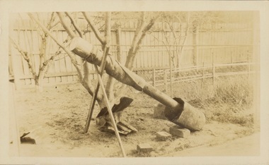
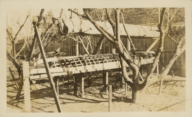
Photograph - Victorian Canoe Club, Steaming gear, 1920-30
... Yarra...Burke Road...Mornington...Studley park...Yarra at Melbourne was an important and widespread recreational pursuit for Melbournians, especially in the first half of the twentieth century. The Victorian Canoe Club was formed in 1912 at a meeting in Melbourne and its first committee elected in the same year. Records indicate that the Club continued into at least the 1950s . The album has historic and social significance as a record of recreational activities (as well as canoe making) in the early years of the twentieth century. It has local significance as the site of the headquarters of the Club was in Studley park ...Canoeing on the River Yarra at Melbourne was an important and widespread recreational pursuit for Melbournians, especially in the first half of the twentieth century. The Victorian Canoe Club was formed in 1912 at a meeting in Melbourne and its first committee elected in the same year. Records indicate that the Club continued into at least the 1950s .The album has historic and social significance as a record of recreational activities (as well as canoe making) in the early years of the twentieth century. It has local significance as the site of the headquarters of the Club was in Studley park. A number of photographs in the album provide vistas of Kew on the Yarra that are otherwise unavailable.One of 24 labelled photos in part album, originating from the Victorian Canoe Club, which had its headquarters in Studley Park, Kew. The album includes a photographic record of canoe construction and also locations in Studley Park and Kew where the canoes were used. The subject of this photograph is identified as 'Steaming gear' which was the equipment used in a backyard to heat and soften the wood used to make a canoe so that it would be pliable and could respond to a mould."Steaming gear"victorian canoe club, canoe making, river yarra, burke road, mornington, studley park, kew, steaming gear, canoe construction -
 Kew Historical Society Inc
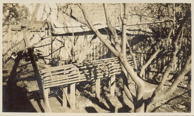
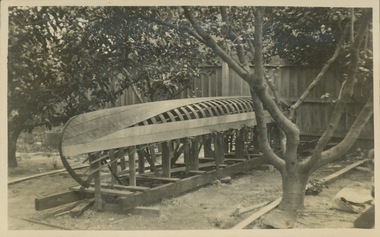
Photograph - Victorian Canoe Club, Mould for racer, 1920-30
... Yarra that are otherwise unavailable. Victorian Canoe Club Canoe making canoe construction canoe moulds "Mould for racer" One of 24 labelled photos in part album, originating from the Victorian Canoe Club, which had its headquarters in Studley Park, Kew. ...Canoeing on the River Yarra at Melbourne was an important and widespread recreational pursuit for Melbournians, especially in the first half of the twentieth century. The Victorian Canoe Club was formed in 1912 at a meeting in Melbourne and its first committee elected in the same year. Records indicate that the Club continued into at least the 1950s .The album has historic and social significance as a record of recreational activities (as well as canoe making) in the early years of the twentieth century. It has local significance as the site of the headquarters of the Club was in Studley park. A number of photographs in the album provide vistas of Kew on the Yarra that are otherwise unavailable.One of 24 labelled photos in part album, originating from the Victorian Canoe Club, which had its headquarters in Studley Park, Kew. The album includes a photographic record of canoe construction and also locations in Studley Park and Kew where the canoes were used. The subject of this photograph is identified as 'Mould for racer' which was set up in a backyard to form the frame for manufacturing a racing canoe."Mould for racer"victorian canoe club, canoe making, canoe construction, canoe moulds -
 Kew Historical Society Inc
Photograph - Victorian Canoe Club, Ribs bent on mould, 1920-30
... Yarra that are otherwise unavailable. Victorian Canoe Club Canoe making canoe construction "Ribs bent on mould" One of 24 labelled photos in part album, originating from the Victorian Canoe Club, which had its headquarters in Studley Park, Kew. ...Canoeing on the River Yarra at Melbourne was an important and widespread recreational pursuit for Melbournians, especially in the first half of the twentieth century. The Victorian Canoe Club was formed in 1912 at a meeting in Melbourne and its first committee elected in the same year. Records indicate that the Club continued into at least the 1950s .The album has historic and social significance as a record of recreational activities (as well as canoe making) in the early years of the twentieth century. It has local significance as the site of the headquarters of the Club was in Studley park. A number of photographs in the album provide vistas of Kew on the Yarra that are otherwise unavailable.One of 24 labelled photos in part album, originating from the Victorian Canoe Club, which had its headquarters in Studley Park, Kew. The album includes a photographic record of canoe construction and also locations in Studley Park and Kew where the canoes were used. The subject of this photograph is identified as 'Ribs bent on mould' after being softened by steaming."Ribs bent on mould"victorian canoe club, canoe making, canoe construction -
 Kew Historical Society Inc
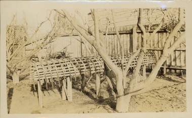
Photograph - Victorian Canoe Club, Planking, 1920-30
... Yarra that are otherwise unavailable. Victorian Canoe Club Canoe making canoe construction "Planking" One of 24 labelled photos in part album, originating from the Victorian Canoe Club, which had its headquarters in Studley Park, Kew. ...Canoeing on the River Yarra at Melbourne was an important and widespread recreational pursuit for Melbournians, especially in the first half of the twentieth century. The Victorian Canoe Club was formed in 1912 at a meeting in Melbourne and its first committee elected in the same year. Records indicate that the Club continued into at least the 1950s .The album has historic and social significance as a record of recreational activities (as well as canoe making) in the early years of the twentieth century. It has local significance as the site of the headquarters of the Club was in Studley park. A number of photographs in the album provide vistas of Kew on the Yarra that are otherwise unavailable.One of 24 labelled photos in part album, originating from the Victorian Canoe Club, which had its headquarters in Studley Park, Kew. The album includes a photographic record of canoe construction and also locations in Studley Park and Kew where the canoes were used. The subject of this photograph is identified as 'Planking' where the wooden planks forming the hull have been softened by steaming and bent to conform to the shape of the mould."Planking"victorian canoe club, canoe making, canoe construction -
 Kew Historical Society Inc
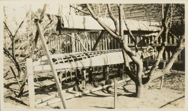
Photograph - Victorian Canoe Club, Planking, 1920-30
... Yarra that are otherwise unavailable. Victorian Canoe Club Canoe making canoe construction "Planking" One of 24 labelled photos in part album, originating from the Victorian Canoe Club, which had its headquarters in Studley Park, Kew. ...Canoeing on the River Yarra at Melbourne was an important and widespread recreational pursuit for Melbournians, especially in the first half of the twentieth century. The Victorian Canoe Club was formed in 1912 at a meeting in Melbourne and its first committee elected in the same year. Records indicate that the Club continued into at least the 1950s .The album has historic and social significance as a record of recreational activities (as well as canoe making) in the early years of the twentieth century. It has local significance as the site of the headquarters of the Club was in Studley park. A number of photographs in the album provide vistas of Kew on the Yarra that are otherwise unavailable.One of 24 labelled photos in part album, originating from the Victorian Canoe Club, which had its headquarters in Studley Park, Kew. The album includes a photographic record of canoe construction and also locations in Studley Park and Kew where the canoes were used. The subject of this photograph is identified as 'Planking' where the wooden planks forming the hull have been softened by steaming and bent to conform to the shape of the mould."Planking"victorian canoe club, canoe making, canoe construction -
 Kew Historical Society Inc
Photograph - Victorian Canoe Club, Planking, 1920-30
... Yarra that are otherwise unavailable. Victorian Canoe Club Canoe making canoe construction "Planking" One of 24 labelled photos in part album, originating from the Victorian Canoe Club, which had its headquarters in Studley Park, Kew. ...Canoeing on the River Yarra at Melbourne was an important and widespread recreational pursuit for Melbournians, especially in the first half of the twentieth century. The Victorian Canoe Club was formed in 1912 at a meeting in Melbourne and its first committee elected in the same year. Records indicate that the Club continued into at least the 1950s .The album has historic and social significance as a record of recreational activities (as well as canoe making) in the early years of the twentieth century. It has local significance as the site of the headquarters of the Club was in Studley park. A number of photographs in the album provide vistas of Kew on the Yarra that are otherwise unavailable.One of 24 labelled photos in part album, originating from the Victorian Canoe Club, which had its headquarters in Studley Park, Kew. The album includes a photographic record of canoe construction and also locations in Studley Park and Kew where the canoes were used. The subject of this photograph is identified as 'Planking' where the wooden planks forming the hull have been softened by steaming and bent to conform to the shape of the mould."Planking"victorian canoe club, canoe making, canoe construction -
Kew Historical Society Inc
Album - Victorian Canoe Club : Album 2, 1931-5
... Yarra as well as to regional Victoria. All but one of the photographs in the album were labelled by the owner in white ink. The individual photographs in this album are also posted on Victorian Collections separately, typically under the label of the photo in the album. E.g "Salvaging wrecked canoe". Descriptive titles in the album include (sometimes referring to two photos): Xmas 1930, Leaving Studley Park...Yarra as well as to regional Victoria. All but one of the photographs in the album were labelled by the owner in white ink. The individual photographs in this album are also posted on Victorian Collections separately, typically under the label of the photo in the album. E.g "Salvaging wrecked canoe". Descriptive titles in the album include (sometimes referring to two photos): Xmas 1930, Leaving Studley Park ...Canoeing on the River Yarra at Melbourne was an important and widespread recreational pursuit for Melbournians, especially in the first half of the twentieth century. The Victorian Canoe Club was formed in 1912 at a meeting in Melbourne and its first committee elected in the same year. Records indicate that the Club continued into at least the 1950s .The album has historic and social significance as a record of recreational activities in the early years of the twentieth century.Part of an unbound old album, containing photographs of members of the Victorian Canoe Club undertaking a series of trips to the lower and upper Yarra as well as to regional Victoria. All but one of the photographs in the album were labelled by the owner in white ink. The individual photographs in this album are also posted on Victorian Collections separately, typically under the label of the photo in the album. E.g "Salvaging wrecked canoe". Descriptive titles in the album include (sometimes referring to two photos): Xmas 1930, Leaving Studley Park / Breakfast on wharf after camping on lower Yarra / repacking / Old Cerberus / Shooting the rapids, Warrandyte / [Untitled] / Pound Bend tunnel (2) / Old mine / Salvaging wrecked canoe / Mallacoota trip / Gippsland LakesNil apart from individual photo labelsvictorian canoe club, river yarra, kew, warrandyte, upper yarra, lower yarra, cerberus, mallacoota, recreation -- canoeing -
 Kew Historical Society Inc
Photograph - Victorian Canoe Club, Xmas 1930, leaving Studley Park
... The first photo reveals three of the four club members leaving their clubhouse in Studley Park to travel downstream to the Lower Yarra and beyond to Port Phillip Bay. ...The first photo reveals three of the four club members leaving their clubhouse in Studley Park to travel downstream to the Lower Yarra and beyond to Port Phillip Bay. ...Canoeing on the River Yarra at Melbourne was an important and widespread recreational pursuit for Melbournians, especially in the first half of the twentieth century. The Victorian Canoe Club was formed in 1912 at a meeting in Melbourne and its first committee elected in the same year. Records indicate that the Club continued into at least the 1950s .The photos in this album are historically and socially significant as a record of recreational activities in the first half of the twentieth century. A number of photographs in the album provide views of sections of the Yarra, as well as areas in regional Victoria, that may otherwise be unavailable.One of 12 sepia [faded] photographs of members of the Victorian Canoe Club. The first photo reveals three of the four club members leaving their clubhouse in Studley Park to travel downstream to the Lower Yarra and beyond to Port Phillip Bay. "Xmas 1930. Leaving Studley Park"victorian canoe club, river yarra, travel -- 1930s, canoeing -
 Kew Historical Society Inc
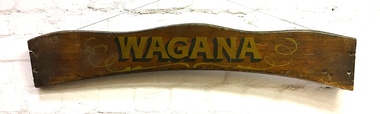
Sign, Wagana, 1920s
... Yarra was a very popular weekend pastime. Each of the early boats was individually named in gold letters on its varnished wooden backboard. This is all that remains of one of the Thames pulling boats from Burns' Boatshed at Studley Park which was destroyed by a falling tree in a storm. ...Yarra was a very popular weekend pastime. Each of the early boats was individually named in gold letters on its varnished wooden backboard. This is all that remains of one of the Thames pulling boats from Burns' Boatshed at Studley Park which was destroyed by a falling tree in a storm. ...In the 1920s and 30s, rowing on the Yarra was a very popular weekend pastime. Each of the early boats was individually named in gold letters on its varnished wooden backboard. This is all that remains of one of the Thames pulling boats from Burns' Boatshed at Studley Park which was destroyed by a falling tree in a storm. Their entire fleet of rowing boats has now been replaced by fiberglass boats.Varnished wooden backplate of a rowing boat. The shaped sign is embossed with the name 'Wagana" in gold lettering, outlined and shaded in black paint. Gilt scroll work surrounds the name. The ends of the backplate shows the holes where the plate was once attached to the seat of the boat. The name Wagana means 'to dance' in Wiradjuri language."Wagana"burns' boatshed, thames pulling boats, yarra river -- kew (vic.), boathouses - river yarra -
 Kew Historical Society Inc
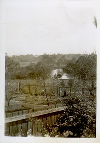
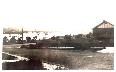
Photograph - View of the Yarra River from 8 Kellett Grove, North Kew, 1948
... The view from the rear of 8 Kellett Grove predates the construction of the Eastern Freeway so provides a rare view of the area before it was built. yarra river -- north kew kellett grove -- north kew Verso: NORTH KEW 1948 / Stamped 51019 Small sepia snapshot taken from the back yard of a house at 8 Kellett Grove, in what was then known as North Kew. A tower of the Kew Asylum on the top left of the horizon assist the viewer to recognise that the land to the left of the river is in Kew and Studley Park. ...North Kew, now divided between Kew and Kew East, bordered the Yarra River. As such, it was a region subject to flooding in the Yarra Valley. Development beyond this point (ie Kellett Grove) was limited by the City of Kew's planning regulations. Prior to urban development, the area since European settlement and the first land sales in the district in the 1840s, had been used for dairy farming. The view from the rear of 8 Kellett Grove predates the construction of the Eastern Freeway so provides a rare view of the area before it was built.Small sepia snapshot taken from the back yard of a house at 8 Kellett Grove, in what was then known as North Kew. A tower of the Kew Asylum on the top left of the horizon assist the viewer to recognise that the land to the left of the river is in Kew and Studley Park.Verso: NORTH KEW 1948 / Stamped 51019yarra river -- north kew, kellett grove -- north kew -
 Kew Historical Society Inc
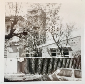
Photograph - 'Villa Alba', 44 Walmer Street, 1981
... Villa Alba, a two-storeyed residence with rendered masonry walls and a slate roof, stands opposite Studley Park, overlooking the Yarra River. It is believed to have been first built before 1863, but substantially remodelled and enlarged in about 1882-83 for William Greenlaw, the Manager of the Colonial Bank of Australasia. ...Kew Historical Society Inc Kew Court House 188 High Street Kew melbourne Villa Alba, a two-storeyed residence with rendered masonry walls and a slate roof, stands opposite Studley Park, overlooking the Yarra River. It is believed to have been first built before 1863, but substantially remodelled and enlarged in about 1882-83 for William Greenlaw, the Manager of the Colonial Bank of Australasia. ...Villa Alba, a two-storeyed residence with rendered masonry walls and a slate roof, stands opposite Studley Park, overlooking the Yarra River. It is believed to have been first built before 1863, but substantially remodelled and enlarged in about 1882-83 for William Greenlaw, the Manager of the Colonial Bank of Australasia. Although the house and its tower must always have been a landmark in the area and the architecture is unusual, almost Norman in style, it is the interior which is the most remarkable feature of Villa Alba. (Source: VHD)Small black and white photographic positive of Vila Alba, 44 Walmer Street, Kew in 1981 when the original 1880s house was surrounded by hospital wards. The latter had been built by the Royal Women's Hospital after it acquired the site in 1950. The site wa Slater transferred to the Mount Royal Hospital before being purchased and converted into a museum of interior design.Verso: "Villa Alba 1981"villa alba -- 44 walmer street -- kew (vic.), mount royal hospital, henry pride wing -
 Kew Historical Society Inc
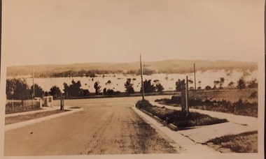
Photograph - Yarra Valley Floods: Kew East, 1916
... Yarra in Kew was devoted to dairy farming. In the twentieth century, before and after the construction of the Eastern Freeway, much of this low-lying area was used as golf courses and public parks....Yarra in Kew was devoted to dairy farming. In the twentieth century, before and after the construction of the Eastern Freeway, much of this low-lying area was used as golf courses and public parks. ...Flooding of the Yarra Valley, including that section of the Yarra bordering Kew and Kew East in the north and west of the municipality, was a regular occurrence. Extreme flood events of the Yarra River are recorded to have occurred in 1891, 1901, 1916, 1923 and 1934. The Municipality of Kew's response to these floods was to enact planning decisions restricting residential development in flood prone areas following the floods of 1916, 1921 and 1934. While floods continued after the development of the Upper Yarra Reservoir (construction 1948-57), the regularity and extent of these inundations diminished. During the nineteenth century, the land abutting the south side of the Yarra in Kew was devoted to dairy farming. In the twentieth century, before and after the construction of the Eastern Freeway, much of this low-lying area was used as golf courses and public parks.One of a collection of photographs of flooding in the Kew section of the Yarra Valley which are in important research resource for the location and extent of flooding in the first half of the twentieth century. Flooding of the Yarra Valley at East Kew in 1916. The view is taken from the intersection of Kilby Road with what is believed to be Birdwood Street, looking across the flood waters to Ivanhoe. The extensive flooded area shown in the photograph would have included the Kew Golf Club. Verso: "Floods along Kilby Road / near Birdwood St? & Kilby Road / 1917? / 87yarra river, yarra valley, floods -- kew, kilby road -- kew (vic.), kew golf club -
 Kew Historical Society Inc
Photograph - Yarra Valley at Kew, 1918
... Yarra in Kew was devoted to dairy farming. In the twentieth century, before and after the construction of the Eastern Freeway, much of this low-lying area was used as golf courses and public parks....Yarra in Kew was devoted to dairy farming. In the twentieth century, before and after the construction of the Eastern Freeway, much of this low-lying area was used as golf courses and public parks. yarra river yarra valley Verso: "Willsmere / East Kew? ...During the nineteenth century, the land abutting the south side of the Yarra in Kew was devoted to dairy farming. In the twentieth century, before and after the construction of the Eastern Freeway, much of this low-lying area was used as golf courses and public parks.View of the farmland in the Yarra Valley at what is believed to be East Kew in 1918. Verso: "Willsmere / East Kew? / 1918"yarra river, yarra valley -
 Kew Historical Society Inc
Photograph - Yarra Valley Floods: Kew East, 1916
... Yarra in Kew was devoted to dairy farming. In the twentieth century, before and after the construction of the Eastern Freeway, much of this low-lying area was used as golf courses and public parks....Yarra in Kew was devoted to dairy farming. In the twentieth century, before and after the construction of the Eastern Freeway, much of this low-lying area was used as golf courses and public parks. ...Flooding of the Yarra Valley, including that section of the Yarra bordering Kew and Kew East in the north and west of the municipality, was a regular occurrence. Extreme flood events of the Yarra River are recorded to have occurred in 1891, 1901, 1916, 1923 and 1934. The Municipality of Kew's response to these floods was to enact planning decisions restricting residential development in flood prone areas following the floods of 1916, 1921 and 1934. While floods continued after the development of the Upper Yarra Reservoir (construction 1948-57), the regularity and extent of these inundations diminished. During the nineteenth century, the land abutting the south side of the Yarra in Kew was devoted to dairy farming. In the twentieth century, before and after the construction of the Eastern Freeway, much of this low-lying area was used as golf courses and public parks.One of a collection of photographs of flooding in the Kew section of the Yarra Valley which are in important research resource for the location and extent of flooding in the first half of the twentieth century. Flooding of the Yarra Valley at East Kew in 1916. The view is taken from a street (maybe Birdwood Avenue) intersecting with Kilby Road looking northeast across the flood waters to Ivanhoe and Heidelberg. The extensive flooded area shown in the photograph would have included remnant dairy farms and the Kew Golf Club. Verso: "Floods / Yarra River / East Kew / Kilby Road / 1917? / 87"yarra river, yarra valley, floods -- kew, kilby road -- kew (vic.), kew golf club -
 Kew Historical Society Inc
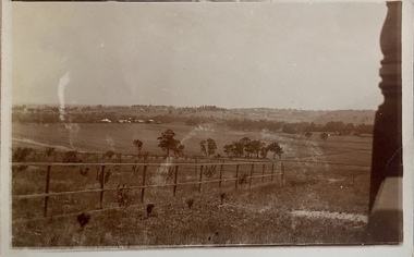
Photograph - Yarra Valley at Kew, 1912
... Yarra in Kew was devoted to dairy farming. In the twentieth century, before and after the construction of the Eastern Freeway, much of this low-lying area was used as golf courses and public parks....Yarra in Kew was devoted to dairy farming. In the twentieth century, before and after the construction of the Eastern Freeway, much of this low-lying area was used as golf courses and public parks. yarra river yarra valley farming -- kew (vic.) ...During the nineteenth century, the land abutting the south side of the Yarra in Kew was devoted to dairy farming. In the twentieth century, before and after the construction of the Eastern Freeway, much of this low-lying area was used as golf courses and public parks.Real-photo postcard of the farmland in the Yarra Valley in what is believed to be North Kew in 1912. Verso: "Willsmere / East Kew / 1912"yarra river, yarra valley, farming -- kew (vic.) -
 Kew Historical Society Inc
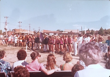
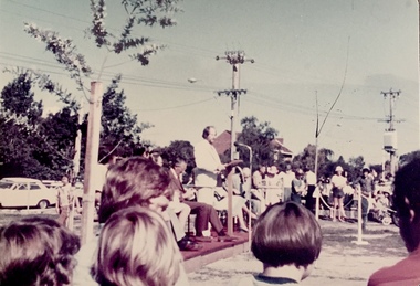
Photograph - Civic event in Stradbroke Park, 1976
... Historical Documentation: 1851 - Portion 91 purchased by Edward Glynn; 1888 - The Harp of Erin Estate (which included Section 91) offered for sale; 1896 - The area now known as Stradbroke Park was bisected by a creek that flowed from the Yarra via Hay's Paddock (q.v.) and extended through to Burke Road; 1943 - W.D. ...Historical Documentation: 1851 - Portion 91 purchased by Edward Glynn; 1888 - The Harp of Erin Estate (which included Section 91) offered for sale; 1896 - The area now known as Stradbroke Park was bisected by a creek that flowed from the Yarra via Hay's Paddock (q.v.) and extended through to Burke Road; 1943 - W.D. ...Stradbroke Park. Extent: Kilby Road to Harp Road at Burke Road. Historical Documentation: 1851 - Portion 91 purchased by Edward Glynn; 1888 - The Harp of Erin Estate (which included Section 91) offered for sale; 1896 - The area now known as Stradbroke Park was bisected by a creek that flowed from the Yarra via Hay's Paddock (q.v.) and extended through to Burke Road; 1943 - W.D. Birrell, Town Clerk of Kew, proposed that the creek be filled and a reserve created; 1954 - Entire area designated as 'open space' and named 'Stradbroke Park'. The line of the creek that ran through the Park created a further reserve on the north side of High Street, now known as 'Harrison Reserve'. Existing Condition: The park is largely of mown grass that has mature trees set into it It is possible that a number of these are remnant of the original vegetation, while there are also a number of exotic trees introduced, particularly at the northern end of the park. The southern end is dominated by playing fields. (Source: Sanderson, P 1988. Kew Conservation Study)Colour photographic positive (with colour degradation) of sporting teams at a civic event in Stradbroke Park in Kew East in May 1976. The event was officiated by the Mayor of Kew, Cr Alan Hutchinson. Sporting teams in uniform included: footballers, athletes, cricketers, hockey players. Stradbroke Park is situated on the western boundary of Kew at Burke and Harp Roads.stradbroke park, cr alan hutchinson, team sports -- kew (vic.) -
 Kew Historical Society Inc
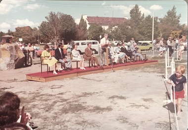
Photograph - Civic event in Stradbroke Park, 1976
... Historical Documentation: 1851 - Portion 91 purchased by Edward Glynn; 1888 - The Harp of Erin Estate (which included Section 91) offered for sale; 1896 - The area now known as Stradbroke Park was bisected by a creek that flowed from the Yarra via Hay's Paddock (q.v.) and extended through to Burke Road; 1943 - W.D. ...Historical Documentation: 1851 - Portion 91 purchased by Edward Glynn; 1888 - The Harp of Erin Estate (which included Section 91) offered for sale; 1896 - The area now known as Stradbroke Park was bisected by a creek that flowed from the Yarra via Hay's Paddock (q.v.) and extended through to Burke Road; 1943 - W.D. ...Stradbroke Park. Extent: Kilby Road to Harp Road at Burke Road. Historical Documentation: 1851 - Portion 91 purchased by Edward Glynn; 1888 - The Harp of Erin Estate (which included Section 91) offered for sale; 1896 - The area now known as Stradbroke Park was bisected by a creek that flowed from the Yarra via Hay's Paddock (q.v.) and extended through to Burke Road; 1943 - W.D. Birrell, Town Clerk of Kew, proposed that the creek be filled and a reserve created; 1954 - Entire area designated as 'open space' and named 'Stradbroke Park'. The line of the creek that ran through the Park created a further reserve on the north side of High Street, now known as 'Harrison Reserve'. Existing Condition: The park is largely of mown grass that has mature trees set into it It is possible that a number of these are remnant of the original vegetation, while there are also a number of exotic trees introduced, particularly at the northern end of the park. The southern end is dominated by playing fields. (Source: Sanderson, P 1988. Kew Conservation Study)Colour photographic positive (with colour degradation) of sporting teams at a civic event in Stradbroke Park in Kew East in May 1976. The event was officiated by the Mayor of Kew, Cr Alan Hutchinson. Stradbroke Park is situated on the western boundary of Kew and bordered by Burke and Harp Roads.stradbroke park, cr alan hutchinson, team sports -- kew (vic.) -
 Kew Historical Society Inc
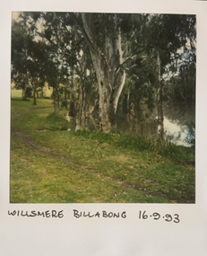
Photograph - Willsmere [Kew] Billabong, 1993
... yarra river -- floods -- kew (vic.)...willsmere park...Willsmere Park is bounded by the the Yarra River, Green Acres Golf Club, Willow Grove and the Eastern Freeway. ...Kew Historical Society Inc Kew Court House 188 High Street Kew melbourne Willsmere Park is bounded by the the Yarra River, Green Acres Golf Club, Willow Grove and the Eastern Freeway. ...Willsmere Park is bounded by the the Yarra River, Green Acres Golf Club, Willow Grove and the Eastern Freeway. The land on which the park is now situated was bought by Thomas Wills at the Crown Land Sales of 1846 (Section 56). From the 1840s to the 1940s it was intensively farmed. The park is dominated by very large playing fields, while planting to the southern boundary was undertaken when the Eastern Freeway was built. It is only along the banks of the Yarra that there is any remnant native vegetation. Willsmere Park is of significance as an area of open land that remains from the flood plain that once dominated northern Kew. (Source: Kew Conservation Study, 1988)Original colour small format polaroid photograph of Willsmere [Kew] Billabong on September 1993."Willsmere Billabong 16.9.93"yarra river -- floods -- kew (vic.), willsmere park -
 Kew Historical Society Inc
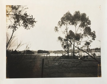
Photograph - Flooding of the Yarra Valley at Kew East, 1974
... Yarra in Kew was devoted to dairy farming. In the twentieth century, before and after the construction of the Eastern Freeway, much of this low-lying area was used as golf courses and public parks....Yarra in Kew was devoted to dairy farming. In the twentieth century, before and after the construction of the Eastern Freeway, much of this low-lying area was used as golf courses and public parks. ...Flooding of the Yarra Valley, including that section of the Yarra bordering Kew and Kew East in the north and west of the municipality, was a regular occurrence. Extreme flood events of the Yarra River are recorded to have occurred in 1891, 1901, 1916, 1923 and 1934. The Municipality of Kew's response to these floods was to enact planning decisions restricting residential development in flood prone areas following the floods of 1916, 1921 and 1934. While floods continued after the development of the Upper Yarra Reservoir (construction 1948-57), the regularity and extent of these inundations diminished. During the nineteenth century, the land abutting the south side of the Yarra in Kew was devoted to dairy farming. In the twentieth century, before and after the construction of the Eastern Freeway, much of this low-lying area was used as golf courses and public parks.Late example of the capacity of the Yarra Valley at Kew to flood, even though drainage works and the Upper Yarra Reservoir had reduced their regularity.Original black and white print photograph of the low-lying land at East Kew under floodwater on 16 May 1974. The vantage point of the photographer is Lister Street. In the photo, the fences of the Kilby Farm can be seen. Flooding was caused by overflowing water in Glass' Creek and the River Yarra. Annotation verso: "Hay's Paddock op No.30 Lister Street / 16 May 1974 11.50am / R.L. 46.04"hays paddock, floods, yarra river, glass' creek, lister street -
 Kew Historical Society Inc
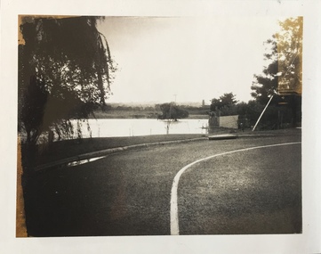
Photograph - Flooding of the Yarra Valley at Kew East, 1974
... Yarra in Kew was devoted to dairy farming. In the twentieth century, before and after the construction of the Eastern Freeway, much of this low-lying area was used as golf courses and public parks....Yarra in Kew was devoted to dairy farming. In the twentieth century, before and after the construction of the Eastern Freeway, much of this low-lying area was used as golf courses and public parks. ...Flooding of the Yarra Valley, including that section of the Yarra bordering Kew and Kew East in the north and west of the municipality, was a regular occurrence. Extreme flood events of the Yarra River are recorded to have occurred in 1891, 1901, 1916, 1923 and 1934. The Municipality of Kew's response to these floods was to enact planning decisions restricting residential development in flood prone areas following the floods of 1916, 1921 and 1934. While floods continued after the development of the Upper Yarra Reservoir (construction 1948-57), the regularity and extent of these inundations diminished. During the nineteenth century, the land abutting the south side of the Yarra in Kew was devoted to dairy farming. In the twentieth century, before and after the construction of the Eastern Freeway, much of this low-lying area was used as golf courses and public parks.Late example of the capacity of the Yarra Valley at Kew to flood, even though drainage works and the Upper Yarra Reservoir had reduced their regularity.Original black and white print photograph of the low-lying land at East Kew under floodwater on 16 May 1974. The vantage point of the photographer is Lister Street. Flooding was caused by overflowing water in Glass' Creek and the River Yarra. Annotation verso: "Lister Street looking north / Flood level / 16 May 1974 11.30am / R.L. 46.04"hays paddock, floods, yarra river, glass' creek, lister street