Showing 2831 items
matching fences
-
 Lakes Entrance Historical Society
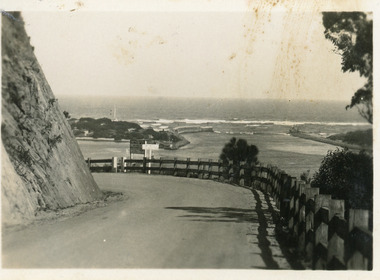
Postcard - The Entrance, Bulmer H.D, 1940c
Black and white small format postcard showing a bend in the Princes Highway on the Kalimna Hill. The road runs between the steep road cutting and post and rail guard fence. The artificial entrance from Bass Strait to Lakes system is in view. Lakes Entrance Victoriawaterways, islands -
 Lakes Entrance Historical Society
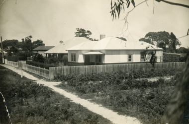
Photograph, 1930
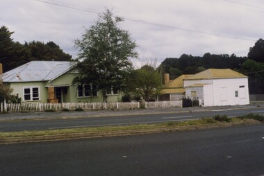
Bracken fern covered lane beside property late developed as Lambert Street.Black and white photograph of a house in Myer Street, clad in cement sheet with hipped roof, clipped hedge inside wire lace front fence, footpath in front of property is unsealed. House at 37 Myer Street, in background, known as Ardlui. Lakes Entrance Victoriaroads and streets, houses, heritage study -
 Lakes Entrance Historical Society
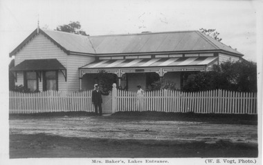
Photograph, Vogt W S, 1910c
Also enlargement 18 x 25, also sepia toned copy from postcard titled Mrs Baker's, Lakes Entrance. Guest House conducted by Mrs Zelie Alphonsine Baker, previously Lake, nee Ducret. Husband George 'Brinet' Baker. Later proprietors were Mrs Syd Ashton, 1930's, and Gerlands, 1950's. Site now occupied by Lakes Photographics, King and Heath shops, all Myers St (west side) to Church StBlack and white photograph of St Rosieres Boarding House. showing weatherboard residence, corrugated iron roof, half veranda at front, timber awning over windows of gabled room. George - Briney - Baker and wife Zelie at front fence. Lakes Entrance Victoriatourism, guesthouses, architecture -
 Sunbury Family History and Heritage Society Inc.
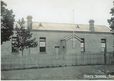
Photograph - Sunbury State School, C1880 - 1910
The building in the photograph was the first Sunbury State School No.1002. Prior to the school being built, lessons were conducted in the Presbyterian Church. After parents organised a petition in 1869 for the school to be housed in a proper building and a committee of management was formed, work on a new school building commenced. The old building had many structural deficiencies and the red brick building was built on the same site in 1911. A non-digital black and white photograph of an austere looking rendered building with a flagpole attached to a small portico at the entrance of the building. The roof is corrugated iron and has two air vents and two chimneys on it. There is a picket fence with a gate across the front and a tree is growing in the front.sunbury state school no. 1002., macedon street, stawell street -
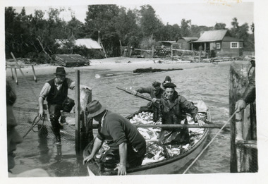 Lakes Entrance Historical Society
Photograph, 1947c
Also black and white enlargement 11.5 x 16Black and white small format photograph of fishermen at the fish pens in lake at Western Side of entrance. Four men in rowing boat loaded with fish, one man on fence, another holding rope to steady boat. Fishermen's cottages in background. Lakes Entrance Victoriafishing industry, boats and boating, waterways, occupation, fish -
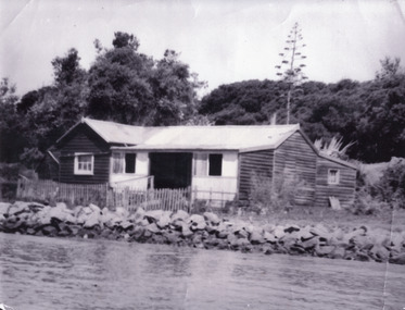 Lakes Entrance Historical Society
Photograph - Schnapper Cottage, 1944
Black and white photograph showing, Schnapper cottage on western side of entrance. Dark weatherboards, front partially screened in, picket fence along front, rocks along shoreline, thick vegetation on dunes, tall century plant at rear of house. Lakes Entrance Victoria waterfront, historic buildings -
 Bendigo Historical Society Inc.
Negative - DUDLEY HOUSE COLLECTION: NEGATIVES OF DUDLEY HOUSE PLUS 3 IMAGES
Dudley House brick building is one of the earliest and most intact 1850s buildings remaining in Bendigo CBD. Like all government buildings of this era, its exterior is fairly modest, unlike the opulent styles of later decades. It was originally built as a residence for the district surveyor, who designed the Bendigo street layout that we still use to this day. Strip of Photo Negatives of Dudley House in View Street Bendigo, Victoria Australia. 3 Images date unknown, but car parked out of front of property is from the 1960s. Looks like a wooden fence is enclosing the property can we date image from this?bendigo, buildings, dudley house -
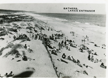 Lakes Entrance Historical Society
Postcard - Ocean Beach, 1950c
2 other copiesBlack and white small format postcard of bathers at the ocean beach. It shows a crowd of people on the sand dunes, remains of a brush fence, Southern Ocean and Red Bluff in distance. Taken from original tower, built for Royal Lifesaving Club. Lakes Entrance VictoriaBathers, Lakes Entrance topography, people, beaches, recreation -
 Bendigo Historical Society Inc.
Photograph - BILL ASHMAN COLLECTION: COHUNA BUTTER FACTORY
Black and white photo of the exterior of the Cohuna Butter Factory. In the foreground are fences and double wooden gates. The factory has a truck parked in front of it. To the left is a large chimney. In front are three tanks on high stands and a long stack of fire wood. Name written on the back.sciences, bill ashman collection - correspondence, cohuna butter factory -
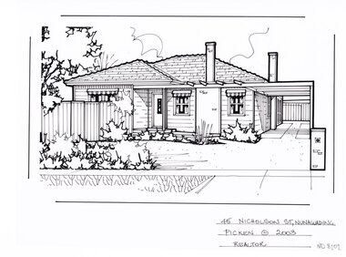 Whitehorse Historical Society Inc.
Artwork, other - Ink Line Drawing, Margaret Picken, 45 Nicholson St., Nunawading, 2003
A property illustration by Margaret Picken Commissioned by a real estate agency for the purpose of advertising 45 Nicholson St., Nunawading. This property is listed as having sold for $372,000 in 2003 Made by using Rotring ‘Rapidigraph’ drafting pens with Rotring ink on Rapidigraph polyester drafting film, double matte. Trained as a cartographic draftsman within the mining industry, Margaret Picken is an artist who worked producing property illustrations for real estate agencies in eastern suburbs of Victoria from 1983-2005. Retiring from the industry as technological changes favored coloured photography over illustrations, and commissioning companies over sole contractors.This artwork is of Historical Significance as a record of local domestic architecture.A black ink line drawing on drafters film by Margaret Picken, of a black and white line drawing of a single story weatherboard house. On the right is a driveway leading to a connected carport, and curving around in front of the house. On the left is a front garden in the foreground, and a gated fence to the backyard.45 Nicholson St., Nunawading Picken © 2003 Realtorwhitehorse historical society, schwerkolt cottage, housing, architecture, margaret picken, house, garden, real estate, nunawading -
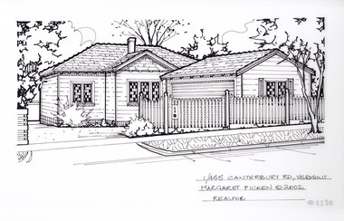 Whitehorse Historical Society Inc.
Artwork, other - Ink Line Drawing, Margaret Picken, 1/455 Canterbury Rd., Vermont, 2002
A property illustration by Margaret Picken Commissioned by a real estate agency for the purpose of advertising 1/455 Canterbury Rd., Vermont This property is listed as having sold for $233,500 in 2002 Made by using Rotring ‘Rapidigraph’ drafting pens with Rotring ink on Rapidigraph polyester drafting film, double matte. Trained as a cartographic draftsman within the mining industry, Margaret Picken is an artist who worked producing property illustrations for real estate agencies in eastern suburbs of Victoria from 1983-2005. Retiring from the industry as technological changes favored coloured photography over illustrations, and commissioning companies over sole contractors.This artwork is of Historical Significance as a record of local domestic architecture.A black ink line drawing on drafters film by Margaret Picken, of a black and white line drawing of a single story weatherboard house with a driveway on the left leading into the background, and curving right toward a built in garage in front of the house. In the foreground in a picket fence, enclosing the property. 1/455 Canterbury Rd., Vermont Margaret Picken © 2002 Realtorwhitehorse historical society, schwerkolt cottage, housing, architecture, margaret picken, house, garden, real estate, vermont, vermont south -
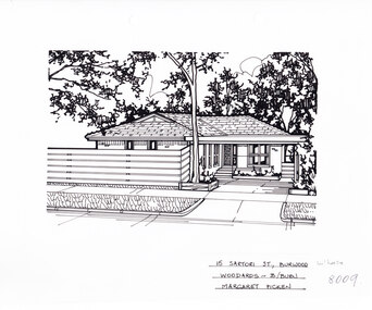 Whitehorse Historical Society Inc.
Artwork, other - Ink Line Drawing, 15 Satori St., Burwood, circa 1983-2005
A property illustration by Margaret Picken Commissioned by the real estate agency Woodards for the purpose of advertising 15 Satori St., Burwood Made by using Rotring ‘Rapidigraph’ drafting pens with Rotring ink on Rapidigraph polyester drafting film, double matte. Trained as a cartographic draftsman within the mining industry, Margaret Picken is an artist who worked producing property illustrations for real estate agencies in eastern suburbs of Victoria from 1983-2005. Retiring from the industry as technological changes favored coloured photography over illustrations, and commissioning companies over sole contractors.This artwork is of Historical Significance as a record of local domestic architecture.A black ink line drawing on drafters film by Margaret Picken, of 15 Satori St., Burwood. A single story brick house, with a driveway on the left leading to a connected carport which covers the front door. in the foreground is a horizontal plank timber fence, and a tall gumtree.15 Satori St., Burwood Woodards - B.Burn Margaret Pickenwhitehorse historical society, schwerkolt cottage, housing, architecture, margaret picken, burwood, house, garden -
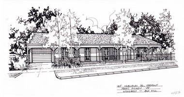 Whitehorse Historical Society Inc.
Artwork, other - Ink Line Drawing, Margaret Picken, 45 Nurlendi Rd., Vermont, 1988
A property illustration by Margaret Picken Commissioned by a real estate agency for the purpose of advertising 45 Nurlendi Rd., Vermont. This property is listed as having sold for $171,500 in 1988 Made by using Rotring ‘Rapidigraph’ drafting pens with Rotring ink on Rapidigraph polyester drafting film, double matte. Trained as a cartographic draftsman within the mining industry, Margaret Picken is an artist who worked producing property illustrations for real estate agencies in eastern suburbs of Victoria from 1983-2005. Retiring from the industry as technological changes favored coloured photography over illustrations, and commissioning companies over sole contractors.This artwork is of Historical Significance as a record of local domestic architecture.A black ink line drawing on drafters film by Margaret Picken, of a single story brick house with veranda across the frontage, on the left it forms a carport in front of the connected garage. In the foreground on the left is the driveway, while on the right is a front garden enclosed by a wrought iron fence.45 Nurlendi Rd., Vermont Marg. Picken '88 Woodards - Boxhillwhitehorse historical society, schwerkolt cottage, housing, architecture, margaret picken, house, garden, real estate, vermont, vermont south -
 Linton and District Historical Society Inc
Photograph, Preston House and Shop, Sussex Street, Linton, 1988
The white corner building was formerly a fruit and vegetable shop which was run by various generations of the Preston family, the last of whom was George Preston. The shop closed in the 1970s and this photo taken in 1988 shows it without its original verandah. Dean Hart afterwards purchased the weatherboard house as a residence and demolished the shop building on the corner.Colour photograph showing a green double-fronted weatherboard house in Sussex Street, Linton. The house has a chimney, pitched roof and a small porch, and a picket fence across the front. A smaller, white-painted building fronts the footpath on the corner of Sussex and Gillespie Streets.buildings, houses, shops, preston's shop, george preston, dean hart -
 Bendigo Historical Society Inc.
Photograph - NORFOLK BREWERY, 1961
black and white photo: rear of Norfok Brewery, mid centre brick building, 2 arched doorways on ground floor, 2 double arched windows top floor, 1 chimney at each end of roof. Lane fence at front. Dove cote, 2 buildings at right. Tall timber building at left centre., Tall timber at left centre. ' Batchelder photographer Pall Mall' van and horse left front. Horse and dray with 3 barrels right front. 3 men handling barrels. Slab fence, slab buildings at right. Written on side of horse cart: Sayer & Co.batchelderbuildings, commercial, produce store -
 Surrey Hills Historical Society Collection
Photograph, 5 York Street, Mont Albert, November 1999 (1), 1999
This is the home of Ernest Augustus Young (1891-1985) and Ruby Nichell Whitby (1892-1984) and their son Ernest Lance Young. Lance was born 24 March 1915 in Surrey Hills; after he married Beryl Mair. Electoral roll for 1937 gives the house name as 'Whitby Lodge'. Ernest and Ruby also had twins Clive and James who died in infancy. Buried at Box Hill Cemetery - M-*-0867 (family plot) This is part of a large collection relating to the Mair, Deakin and Young families. REF: Memoir of Laurie Newton (nee Young) - Her grandfather bought the land and had the house built. She remembers it as having pressed ceilings in some rooms and ornate fireplaces and tiles and leadlight windows in some rooms and doors with leadlight panels. Her grandfather was a keen gardener with an ornamental front garden and many vegetables and fruit trees in the back yard. Her grandfather sold the adjoining block (No 3 York Street), which had been used for growing flowers and vegetables, to John and Edna Jean. Reid. She also remembered that he extended the house and divided it into 2 flats, renting out the northern side for 20 years. Sold by Jellis Craig on 24 December 2010 - With formal living, dining, 3 bedrooms, 2 bathrooms, garage/ample OSP. Land: 18.2m x 40.8m (60' x 134') approx. Large 2 storey house replaced the house. Adjacent house (No 7 York Street) has been renovated. This is part of a large collection relating to the Mair, Deakin and Young families. Colour photo of the street view of 5 York Street, Mont Albert. Taken from the verge, it is a good view of the front of the house. The house is weatherboard with a red corrugated iron roof with simple finials. It is Edwardian in style with simple chimneys in brick and stucco. There is a small veranda with simple fretwork on the southern corner of the house and a bay window to one of the front rooms. There are striped canvas blinds, which are down, on the windows of the 2 front rooms, above which are small lead light windows. The house is partly screened by a mature shrubs. The garden is set behind a fence low fence and constructed from dressed stone. In black permanent marker on rear: "5 YORK ST / NOV. 1999" ernest augustus young, ruby nichell whitby, ruby nichell young, ernest lance young, box hill cemetery, whitby lodge, house names, mont albert -
 Surrey Hills Historical Society Collection
Photograph, 5 York Street, Mont Albert, November 1999 (2), 1999
This is the home of Ernest Augustus Young (1891-1985) and Ruby Nichell Whitby (1892-1984) and their son Ernest Lance Young. Lance was born 24 March 1915 in Surrey Hills; after he married Beryl Mair. Electoral roll for 1937 gives the house name as 'Whitby Lodge'. Ernest and Ruby also had twins Clive and James who died in infancy. Buried at Box Hill Cemetery - M-*-0867 (family plot) This is part of a large collection relating to the Mair, Deakin and Young families. REF: Memoir of Laurie Newton (nee Young) - Her grandfather bought the land and had the house built. She remembers it as having pressed ceilings in some rooms and ornate fireplaces and tiles and leadlight windows in some rooms and doors with leadlight panels. Her grandfather was a keen gardener with an ornamental front garden and many vegetables and fruit trees in the back yard. Her grandfather sold the adjoining block (No 3 York Street), which had been used for growing flowers and vegetables, to John and Edna Jean. Reid. She also remembered that he extended the house and divided it into 2 flats, renting out the northern side for 20 years. Sold by Jellis Craig on 24 December 2010 - With formal living, dining, 3 bedrooms, 2 bathrooms, garage/ample OSP. Land: 18.2m x 40.8m (60' x 134') approx. Large 2 storey house replaced the house. Adjacent house (No 7 York Street) has been renovated. This is part of a large collection relating to the Mair, Deakin and Young families. Colour photo of the street view of 5 York Street, Mont Albert. Taken from the rear of the house verge, it is a good view of the front of the house. The house is weatherboard with a red corrugated iron roof with simple finials. It is Edwardian in style with simple chimneys in brick and stucco. There is a small veranda with simple fretwork on the southern corner of the house and a bay window to one of the front rooms. There are striped canvas blinds, which are down, on the windows of the 2 front rooms, above which are small lead light windows. The house is partly screened by a mature shrubs. The garden is set behind a fence low fence and constructed from dressed stone. In black permanent marker on rear: "5 YORK ST / NOV. 1999" ernest augustus young, ruby nichell whitby, ruby nichell young, ernest lance young, box hill cemetery, whitby lodge, house names, mont albert -
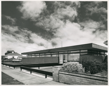 Royal District Nursing Service (now known as Bolton Clarke)
Photograph - Photograph, black and white, 30 06 1965
This photograph is a record of the Melbourne District Nursing Service (MDNS) Moorabbin Centre, situated at 611 South Road, Moorabbin. It was opened in mid 1965 and was the fourth Centre MDNS had opened. Following Royal patronage in 1966, it became known as Royal District Nursing Service (RDNS) Moorabbin Centre.Gradually over the years, Melbourne District Nursing Service, MDNS, later known as Royal District Nursing Service, RDNS, from 1966 when they received Royal patronage, opened Centres throughout the Melbourne Metropolitan area. Their Trained nurses (Sisters) left from these Centres each morning to carry out their nursing visits in a specific area, taking any sterilized equipment needed with them. They returned at the end of the day to write up their patients nursing histories, clean and reset any equipment used ready for sterilization, and to contact other medical personal as necessary. Most of the RDNS cars were housed at each Centre, only a few being driven home by a Sister.Black and white photograph of RDNS Moorabbin Centre. The building is a single story brick building with a flat roof. A row of short glass windows are seen above the brick work to the left of the large glass doors which are on the right of the building. A low standing horizontal fence is seen along the front and along either side of the path leading up to the door. Some bushes are seen in the right hand side garden of the building. A footpath can be seen in front of the fence. On the left of the photograph can be seen a white house with a pitched roof. A dark sky with fluffy white 'cumulus' clouds are seen above the buildings.Photographers stamp. Quote No. DX 18mdns, melbourne district nursing service, mdns centres, royal district nursing service, rdns -
 Phillip Island and District Historical Society Inc.
Photograph, 1920
"Waiting to meet the Boat". Cowes Post Office, corner Main Street and The Esplanade. A brick building with corrugated iron roof, two brick chimneys, a porch extending across front verandah, wooden posts, awning roof striped. Fencing across with free access above four steps. Ten figures on verandah and in front with hats, bags and jackets. Women with long skirts and dresses. In foreground a small fenced area.Post Office, crn Esplanade and Main Street, Coweslocal history, photographs, buildings - historic, post office, black & white photograph, mary robb -
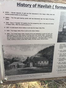 Kiewa Valley Historical Society
Papers - Havilah Cemetery, Havilah Cemetery Formerly Running Creek Cemetery
In 1889, 24 residents of the Running Creek and surrounding district submitted a petition to the Minister of Lands, Melbourne requesting land for a cemetery. Their request was granted. The Cemetery was decommissioned in the early 1950s and the last trustee for the cemetery died in 1986. There is a wooden fence around the boundary (May 2024). One paper lists 29 names in the Burial Register 1861-1948. The last two sheets record the history as a timeline from the 1850s to the 1900s. Havilah was a gold mining settlement from the 1850s located 20km west of the Kiewa Valley and in the Ovens catchment near Myrtleford.Five black and white A4 pages stapled together. Copies of the sign erected at the gate of 'Havilah cemetery formerly Running Creek Cemetery'. Also the 'History of Havilah formerly Running Creek'havilah, running creek, cemetery -
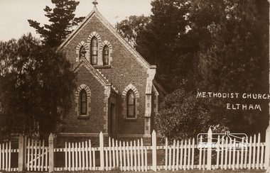 Eltham District Historical Society Inc
Photograph, Eltham Methodist Church, 1909, 1909
Situated at 810 Main Road on the corner of John Street. The Church was surrounded by a picket fence and tall pine trees. The Church was built by George Stebbings in the 1850s and is an example of fine craftmanship. Formerly Wesleyan, Methodist then Uniting church; the foundations of the church building were constructed with stone from the walls of the first Eltham State Primary School (No. 209) building which collapsed in 1874 and were purchased by Robert David Taylor. REVISED STATEMENT OF SIGNIFICANCE, CONTEXT, 2010 via Victorian Heritage Database What is significant? The 1880 bichromatic brick church and the surrounding site to the title boundaries. How is it significant? The church is architecturally, historically, socially and spiritually significant to the Shire of Nillumbik. Why is it significant? The church is architecturally significant as a finely detailed example of a brick 19th century rural community church, one of only four in the Shire (Criteria E & B). The church is historically significant as an important link with the time when Eltham was a small, insular country settlement. Also for the historical evolution visible in the complex, with the modest 1880s church and larger red brick rear hall from the early 20th century as a reflection of population growth in the area (Criterion A). The church is historically, spiritually and socially significant because it has played, and continues to play, an important part in the spiritual and social life of the community (Criterion G).Sepia postcard of Eltham Methodist Church, 1909eltham, methodist church, church, state school no. 209, eltham state school, robert david taylor, eltham uniting church, uniting church, wesleyan church -
 Lake Bolac & District Historical Society
Black and white photograph, "Fintry" Lake Bolac
The house at "Fintry" Lake Bolac, the home of Lewis Whiteway and Victoria May Wills and family and then of Lewis Wills and his wife Amy and their family. The house was constructed in 1906, the materials having been brought up from Geelong by ox-drawn dray. The fence of the tennis court can be seen extreme right with the bay-window of the sitting room through the wire netting. On the road is a wagon-load of redgum for use as strainer-posts.lake bolac, wills, fintry, ox-dray -
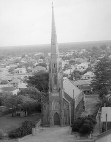 Stawell Historical Society Inc
Photograph, St. Matthew’s Presbyterian Church from town hall clock tower c1959-1960
St. Matthew’s Church 1959-1960 taken from town hall clock tower. Photo taken around 1959 -1960. The Centenary book states brick fence and pillars were a gift from McCracken Family, but not in the year the church was built. This photo was used for the Centenary book cover and was taken from the Town Hall clock tower. The roof line in bottom right corner of photo is rear of town hall.Two photographs of St Matthew's Church taken from the Stawell Town Hall. The photo shows an aerial view of the church and houses behind the church. stawell religion -
 Melton City Libraries
Photograph, Wendy, Bon and Peter Barrie, c.1948
Sections of the property from the Ferris Rd to the Toolern Creek were compulsorily acquired for the construction of the Melton By Pass road to become the Western Freeway. The freeway plan divided the original 1911“Darlingsford” farm. The section of the Ferris Rd 70-acre paddock belonging to Bon became the Freeway and roundabout. The construction to the west passed over the paddocks and the internal track along the fences connecting the Barrie brothers to the original Homestead at the Toolern Creek. Wendy, Bon and Peter Barrie entering Ferris Road from houselocal identities -
 Wodonga & District Historical Society Inc
Album - Ringer's River by Des Martin - Plate 2 - MacLough sacks Neilson as manager of "Gooloora"
MacLough surprises Neilson, erstwile manager of "Gooloora", breakfasting off a bottle of whisky and a cup of black tea, and sacks him on the spot. Ordering the hands to be called together he looks them over and queries the absence of young O'Day. Jackeroo Reg Apperton tells him O'Day is out mending a fence at the back of the stud paddock, and MacLough commands that Apperton drive him out there forthwith. D. Hartsman as Neilson.The album and images are significant because they document literature written by a prominent member of the Wodonga community. The presentation of this precis was supported by several significant district families and individuals.Ringer's River Album Coloured photo Plate 2des martin, many a mile, ringer's river, northeast victoria stories -
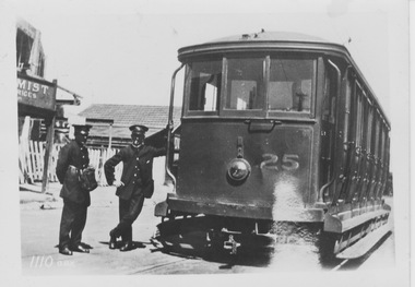 Melbourne Tram Museum
Photograph - VR tram 25, c1920s
The photograph shows VR tram 25 with uniformed tram crew standing on the ground beside the driver's cab entrance with the driver holding a hand rail. On the left is part of a chemist shop verandah and a picket fence. VR 25 originally operated on the broad gauge track from St Kilda Station to Brighton, then in 1919 was converted to standard gauge to operate on the Sandringham to Black Rock line. The location of this photograph is the Black Rock terminus.Yields information about VR tram 25Black and white photograph with notes on the rear.In biro on the rear "Melbourne K J Magor No. per K Train 1110 aBx"vr tram, tram 25, uniformed crew, picket fance, st kilda station, brighton, sandringham, balck rock, broad gauge, standard gauge, terminus -
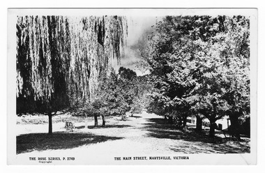 Marysville & District Historical Society
Postcard (Item) - Black and white postcard, Rose Stereograph Company, The Main Street, Marysville, Victoria, 1913-1967
A postcard in a series produced by the Rose Stereograph Company in Victoria, Australia as a souvenir of Marysville.A black and white photograph of Marysville's main street. This is now known as Murchison Street. This postcard was produced by The Rose Stereograph Company as a souvenir of Marysville.POST CARD The "Rose" Series/ De Luxe A Real Photograph/ Produced in Australia Published by the Rose Stereograph Co.,/ Armadale, Victoriamain street, murchison street, marysville, victoria, p. 2749, rose series postcard, postcard, souvenir -
 Bendigo Military Museum
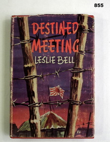
Book, Leslie Bell et al, Destined Meeting, 1960
Red hard cover, blue patch on spine with title & author. Dust cover worn edges, damaged back, authors photo on back. Front red, brown, & mauve colours scene through barbed wire fence with Japanese flag on hut. 256 illustrated pages.On fly leaf: L Schillingbooks, military, history -
 Glenelg Shire Council Cultural Collection
Photograph - Photograph - LB / TB, n.d
Port of Portland Authority Archivesport of portland archives -
 Halls Gap & Grampians Historical Society
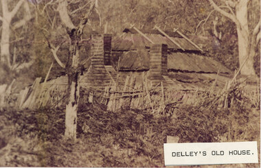
Photograph - Sepia, C 1876
This is a photo of Delley's house. For further information see "Bridging The Gap" p13-14,17,22,54. This photo is an enlargement of a portion of Record 531.Photo shows old house. The roof is constructed of wooden slats held down by pieces of what appears to be fluming. There are two chimneys and the lower half of the house is obscured by a stick fence and undergrowth. There is a large tree in the foreground and another in the far right background. The house is surrounded by bush.buildings, houses