Showing 3729 items matching "landscape"
-
 Flagstaff Hill Maritime Museum and Village
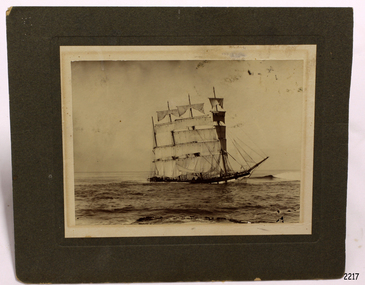
Photograph - Vessel, Sailing Ship, Foyle Photographic Studio, 1908
The photograph is of the sailing ship Falls of Halladale. The ship is in shallow water at Peterborough where it sank on November 14th 1908. The inscription on the photograph reads "Nov 4th 1908". The iron-hulled, four-masted barque, the Falls of Halladale, was a bulk carrier of general cargo. She left New York in August 1908 on her way to Melbourne and Sydney. In her hold, along with 56,763 tiles of unusual beautiful green American slates (roofing tiles), 5,673 coils of barbed wire, 600 stoves, 500 sewing machines, 6500 gallons of oil, 14400 gallons of benzene, and many other manufactured items, were 117 cases of crockery and glassware. Three months later and close to her destination, a navigational error caused the Falls of Halladale to be wrecked on a reef off the Peterborough headland at 3 am on the morning of the 15th of November, 1908. The captain and 29 crew members all survived, but her valuable cargo was largely lost, despite two salvage attempts in 1908-09 and 1910. ABOUT THE ‘FALLS OF HALLADALE’ (1886 - 1908) Built: in1886 by Russell & Co., Greenock shipyards, River Clyde, Scotland, UK. The company was founded in 1870 (or 1873) as a partnership between Joseph Russell (1834-1917), Anderson Rodger and William Todd Lithgow. During the period 1882-92 Russell & Co., standardised designs, which sped up their building process so much that they were able to build 271 ships over that time. In 1886 they introduced a 3000 ton class of sailing vessel with auxiliary engines and brace halyard winches. In 1890 they broke the world output record. Owner: Falls Line, Wright, Breakenridge & Co, 111 Union Street, Glasgow, Scotland. Configuration: Four masted sailing ship; iron-hulled barque; iron masts, wire rigging, fore & aft lifting bridges. Size: Length 83.87m x Breadth 12.6m x Depth 7.23m, Gross tonnage 2085 ton Wrecked: the night of 14th November 1908, Curdies Inlet, Peterborough south west Victoria Crew: 29 The Falls of Halladale was a four-masted sailing ship built-in 1886 in Glasgow, Scotland, for the long-distance cargo trade and was mostly used for Pacific grain trade. She was owned by Wright, Breakenridge & Co of Glasgow and was one of several Falls Line ships, all of which were named after waterfalls in Scotland. The lines flag was of red, blue and white vertical stripes. The Falls of Halladale had a sturdy construction built to carry maximum cargo and able to maintain full sail in heavy gales, one of the last of the ‘windjammers’ that sailed the Trade Route. She and her sister ship, the Falls of Garry, were the first ships in the world to include fore and aft lifting bridges. Previous to this, heavily loaded vessels could have heavy seas break along the full length of the deck, causing serious injury or even death to those on deck. The new, raised catwalk-type decking allowed the crew to move above the deck stormy conditions. This idea is still used today on the most modern tankers and cargo vessels and has proved to be an important step forward in the safety of men at sea. On 4th August 1908, with new sails, 29 crew, and 2800 tons of cargo, the Falls of Halladale left New York, bound for Melbourne and Sydney via the Cape of Good Hope. The cargo on board was valued at £35,000 and included 56,763 tiles of American slate roofing tiles (roof slates), 5,673 coils of barbed wire, 600 stoves, 500 sewing machines, 6,500 gallons of oil, 14,400 gallons of benzene, plumbing iron, 117 cases of crockery and glassware and many other manufactured items. The Falls of Halladale had been at sail for 102 days when, at 3 am on the night of 14th November 1908, under full sail in calm seas with a six knots breeze behind and misleading fog along the coast, the great vessel rose upon an ocean swell and settled on top of a submerged reef near Peterborough on the south-west Victoria’s coast. The ship was jammed on the rocks and began filling with water. The crew launched the two lifeboats and all 29 crew landed safely on the beach over 4 miles away at the Bay of Islands. The postmistress at Peterborough, who kept a watch for vessels in distress, saw the stranding and sent out an alert to the local people. A rescue party went to the aid of the sailors and the Port Campbell rocket crew was dispatched, but the crew had all managed to reach shore safely by the time help arrived. The ship stayed in full sail on the rocky shelf for nearly two months, attracting hundreds of sightseers who watched her slowly disintegrate until the pounding seas and dynamiting by salvagers finally broke her back, and her remains disappeared back into deeper water. The valuable cargo was largely lost, despite two salvage attempts in 1908-09 and 1910. Further salvage operations were made from 1974-1986, during which time 22,000 slate tiles were recovered with the help of 14 oil drums to float them, plus personal artefacts, ship fittings, reams of paper and other items. The Court of Marine Inquiry in Melbourne ruled that the foundering of the ship was entirely due to Captain David Wood Thomson’s navigational error, not too technical failure of the Clyde-built ship. The shipwreck is a popular site for divers, about 300m offshore and in 3 – 15m of water. Some of the original cargo can be seen at the site, including pieces of roof slate and coils of barbed wire. The photograph shows the ship Falls of Halladale in full sail, demonstrating the sails used for power at sea.A sepia landscape photograph; image of a sailing ship in shallow water in full sail. The vessel is the"Falls of Halladale" aground off Peterborough 1908. A figure is in the foreground. Photographed in 1908 by Foyle of Warrnambool. A pencil inscription on the back is underlined. A white sticker is attached.In pencil on reverse "The Falls of Halladale / Wrecked at Peterborough / Nov 4th 1908" [Note: the ship was wrecked on Nov 14th 1908] On white sticker "131"flagstaff hill, flagstaff hill maritime museum and village, warrnambool, maritime museum, maritime village, great ocean road, shipwreck coast, photograph, falls of halladale, sailing ship, vessel, shipwreck, foyle -
 Clunes Museum
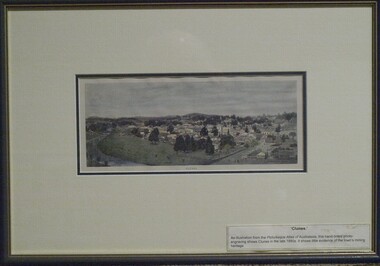
Print - ANTIQUARIAN PRINT, W C FITLER, CLUNES
.1 LITHOGRAPH PRINT COPIED ONTO BUFF PAPER OF CLUNES LANDSCAPE VIEW LOOKING SOUTH EAST MOUNTED AND FRAMED IN BLACK WOOD UNDER GLASS .2 PRINT OF LITHOGRAPH BLACK AND WHITE MOUNTED ON BUFF COLOURED BOARD. COPY OF .1.1 & .2 BELOW PRINT ON BOTTOM IN BLACK INK: CLUNES .1 CERTIFICATE OF AUTHENTICITY FROM LECKIE GALLERY MALDONclunes landscape, lithograph -
 Eltham District Historical Society Inc
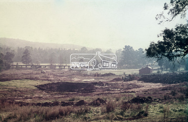
Slide, Construction of Eltham Town Park, 25 Jul 1973
Construction of Eltham Town Park; reclamation of the eastern end of the tip overflow and landscape in progress of being sculptured and lakes formed. Shillinglaw Cottage and the Eltham Trestle Bridge visible. The park was later renamed Alistair Knox Park.35 mm colour positive transparency Mount - Agfacolor Service (Blue)Memorial Park 25 July 1973eltham, alistair knox park, eltham town park, shillinglaw cottage, eltham trestle bridge, eltham tip, trestle bridge -
 Robin Boyd Foundation
Slide, Robin Boyd, 1965
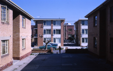
Robin Boyd has written 'Australiana' on the slide mount (item S1081) at the same location. Robin Boyd was always on the lookout for signage and blots on the landscape, especially when writing and illustrating his 1960 book, “The Australian Ugliness”.Colour slide in a mount. Flats, AustraliaMade in Australia / 13 / AUG 65M / Encircled 2 (Handwritten) / Australiana 2 (Handwritten) / 10 (Handwritten) / Encircled 2 (Handwritten)australia, slide, robin boyd -
 Robin Boyd Foundation
Slide, Robin Boyd, 1965
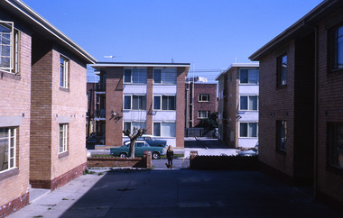
Robin Boyd has written 'Australiana' on the slide mount (item S1081) at the same location. Robin Boyd was always on the lookout for signage and blots on the landscape, especially when writing and illustrating his 1960 book, “The Australian Ugliness”.Colour slide in a mount. Flats, AustraliaMade in Australia / 14 / AUG 65M / Encircled 31 (Handwritten)australia, slide, robin boyd -
 Robin Boyd Foundation
Slide, Robin Boyd, 1965
Robin Boyd has written 'Australiana' on the slide mount (item S1081) at the same location. Robin Boyd was always on the lookout for signage and blots on the landscape, especially when writing and illustrating his 1960 book, “The Australian Ugliness”.Colour slide in a mount. Flats, AustraliaMade in Australia / 15 / AUG 65M / Encircled 10 (Handwritten)melbourne, slide -
 City of Kingston
Photograph - Black and white, 20 December 1945
This aerial photograph depicts the changing landscape of Cheltenham and Highett since WWII. Photographed in 1945, there is a mix of urban dwellings and industrial development and precedes the major transformation of Cheltenham with the development of the Southland shopping centre in the 1960s and expansion in the 1990s.A large part of Cheltenham was originally established as a rural market gardening community. The railway line and station brought urban development to the area and in the north, the Highett area was dominated by the Highett Gas Works. Cheltenham became a major destination for shopping in the 1960s with the opening of Southland.Aerial photograph taken in 1945 of Cheltenham and Highett within the City of Kingston. The image includes the Highett Reserve, (top right), the Methodist Children Homes (now Southland), Nepean Highway and Jamieson Street. Highett Gas Works is visible in the top left and the land now named William Fry Reserve at the intersection of Bay Road and Nepean Highway. A visible large parcel of land on the corner of Bay Road and Nepean Highway was developed in the 1990s as the west side addition to Southland. The densely vegetated area in the upper right sector of the image is now dense with housing. Tulip Grove, Heather Grove and Gilford Street are visible bottom left. This image is possibly from the collection of aerial photographs commissioned by the Department of Crown Lands and Survey and taken by Adastra Airways.Black ink: 57252 White lettering: VIC-10 57252 20.12.45 [lens information indecipherable] PROJ. No.5 MELB. METROP AREA Black pencil: 80highett, cheltenham, highett gas works, urbanisation -
 City of Kingston
Photograph - Black and white, 20 December 1945
This aerial photograph depicts the changing landscape of Cheltenham and Highett since WWII. Photographed in 1945, there is a mix of urban dwellings and industrial development and precedes the major transformation of Cheltenham with the development of the Southland shopping centre in the 1960s and expansion in the 1990s.A large part of Cheltenham was originally established as a rural market gardening community. The railway line and station brought urban development to the area and in the north, the Highett area was dominated by the Highett Gas Works. Cheltenham became a major destination for shopping in the 1960s with the opening of Southland.Aerial photograph taken in 1945 of Cheltenham and Highett within the City of Kingston. The image includes the Highett Reserve, (top right), the Methodist Children Homes (now Southland), Nepean Highway and Jamieson Street. Highett Gas Works is visible in the top left and the land now named William Fry Reserve at the intersection of Bay Road and Nepean Highway. A visible large parcel of land on the corner of Bay Road and Nepean Highway was developed in the 1990s as the west side addition to Southland. The densely vegetated area in the upper right sector of the image is now dense with housing. Tulip Grove, Heather Grove and Gilford Street are visible bottom left. This image is possibly from the collection of aerial photographs commissioned by the Department of Crown Lands and Survey and taken by Adastra Airways.Black type: Reverse lettering VIC-10 57252 20.12.45 [lens information indecipherable] PROJ. No.5 MELB. METROP AREA White lettering: Reverse writing 57252cheltenham, highett, highett gas works, urbanisation -
 Kiewa Valley Historical Society
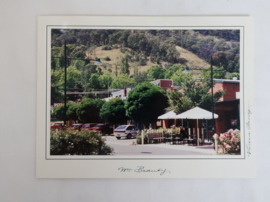
Photo - Mt Beauty, by Vivienne Harvey
Mt Beauty began as a construction town built by the SECV during the construction of the Kiewa Hydro Electric scheme from the 1940s to 1961. This photo gives a glimpse of the development of the town's shopping centre with modern cars and street landscaping.A photo enabling comparisons to be made on the development of the Mt Beauty shopping centre.Coloured shiny photo labelled at the bottom "Mt Beauty" and on right side "Vivienne Harvey". On the white back in black is the name of the photographer and her contact details. The photo is a close up of part of the shopping centre.mt beauty shopping centre -
 Surrey Hills Historical Society Collection
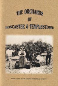
Book, The Orchards of Doncaster & Templestowe
For 100 years Doncaster-Templestowe was a major fruit producing area. The industry had a profound effect on the landscape and vegetation. Although orcharding families came from a variety of backgrounds, German families were an important sub-group.A comprehensive history of fruit growing in the Doncaster-Templestowe area between 1850s and 1950s when orchards began to be subdivided for housing. It includes B&W photos and line drawings and maps. It covers details of the varieties grown, the families involved, pests, machinery involved, markets, blacksmiths and reasons for the demise of the industry in the area.irvine green, eric collyer, doncaster-templestowe historical society, gottlieb thiele, ruffey creek, bismarck street, victoria street, thomas petty, george hislop, john whitten, john clay, august aumann, carl hanke, gottfried uebergang, waldau, max schramm, german lane, george street, john tully, henry crouch, george tortice, august zerbe, jane serpell, sidney williams, phylloxera, joseph bosisto, richard serpell, frederick thiele, w s williams, edwin lawford, james read, john finger, richard clay, ferdinand finger, leeds street, wetherby road, john russell, sarah uebergang, mary hislop, rudolph werner, john petty, archibald mclaren, john hicks, joe hicks, john smedley, william smedley, william hunter, sylvester mullens, laurie's forge, curtis hillman, anne hillman, dan harvey, calder's forge, hillman's blacksmith works, thomas serpell, gill smith, victorian fruit growers association, h g reynolds, alfred thiele, william webb, fred zerbe, mary anne clay, orchardist's coolstore, r h werner & co, j h land, orchardists and fruit cool stores association, a t petty, r read, r chivers, jack noonan, arthur ireland, jack robinson, george knee, donvale cool store, herb petty, frank petty, fred tolly, gordon white, blue moon fruit co-operative ltd, kathleen petty, peg chivers, jack russell, mathew adams, george mcgahy, edwin bullock, james hodson, edwin wilson, david corbett, edwin lowford, thomas beavis, william hanke, tom petty, edward crossman, andrew zander, carl aumann, heinrich fromhold, thomas chivers, william williams, reinhold denhert, henry finger, august furhmann, henry serpell, john ireland, frank smedley, william kent, william knee, thomas buck, henry white, gottlieb leber, alexander speers -
 Ballarat Heritage Services
Photograph - Colour, Bessibelle Drystone Sheep Wash, 2016, 24/04/2016
The Bessiebelle Sheepwashes and Yards complex is located on the former 14,000 acre Ardonachie Run, established in 1848 by pastoralist Samuel Gorrie, then carrying 6,000 sheep. In 1864 this run was subdivided into smaller runs, and the sheep washes were located within Mount Eccles and Lake Gorrie Run. The date of construction of the washes and walls is not known, although they were probably constructed within the period 1848-1864. The Bessiebelle Sheepwashes and Yards are probably the largest and most sophisticated surviving example of a traditional pastoral property sheepwash in Victoria. They clearly demonstrate the large network of races, yards and folds necessary for washing thousands of sheep over a short period of time. The Bessiebelle sheep washes apparently predate later technological changes and the necessity for hot water washing. The Bessiebelle sheepwashes and yards are of landscape significance as a cultural landscape which has been both modified by, and cleverly adapted to, an annual process that was of critical importance within the pastoral calendar. The drystone walls and races appear to evolve from the rocky terrain, and have a strong organic affinity with the prevailing harsh landscape. The drystone walls demonstrate a high level of craftsmanship and skill in their construction, and reflect the extensive scale of pastoral operations across the landscape. The Bessiebelle sheepwashes and yards are of archaeological significance to the State of Victoria. The site has not been fully surveyed but its complexity strongly suggests a potential to reveal more about the washing processes and associated pastoral occupation and activity in the area.(Heritage Victoria)drystone, bessibell, sheep race, sheep wash, agriculture -
 Port Melbourne Historical & Preservation Society
Book, Ralph P Neqale, Jolly Dogs Are We - the history of yachting in Victoria 1835 - 1894, 1984
Jolly Dogs Are We - the history of yachting in Victoria 1838 - 1894, researched between 1970 and 1982 by author Ralph Neale. Hardback volume 338 pp with four-colour dust covertransport - shipping, sport - yachting, societies clubs unions and other organisations, hobson's bay, natural environment - lagoon, ralph p neale, alf hollarnd - sandridge waterman, wilbraham frederick evelyn liardet, wfe liardet -
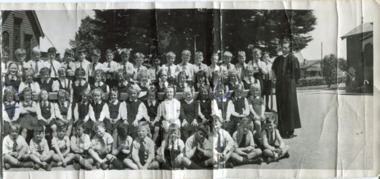 Surrey Hills Historical Society Collection
Digital photo, Our Holy Redeemer school photo, late 1950s (Part 2), 1950s
School history - ref https://ourholyredeemer.cam.org.au/history In 1904 Fr. George Robinson erected a weatherboard school-hall where the present hall now stands. It was blessed and opened by Archbishop Carr on 20th November of that year. In January 1905, the Sisters of St Joseph took charge of the school. Archbishop Mannix opened and blessed the new brick school on 10th November 1918. From 1941-1972, Fr Tim Fitzpatrick was parish priest and head of the school. Personal history: Although they lived in Prospect Street, Box Hill, John and Mary Turnbull attended Our Holy Redeemer School, as did Susan Hirst who lived across the road from the Turnbull family with her parents Ray and Shirley Hirst at 29 Prospect Street.Part of a large landscape black and white photo of a priest with a large group of children grouped as follows: Back row: 19 boys Second back row: 14 girls Second row: 15 girls Front row: 12 boys. Behind the group is a large cypress tree and to either side the church and (?) school building. The girl in the 2nd row, first on the left is marked with an 'T' in blue biro; the girl 3rd from the right in the same row is circled in blue biro. There is a Californian bungalow in the background. This is half of a large landscape photo and the 2 pieces should be viewed together. On front 'T' and a circle in blue biro are believed by the donor to have been made by Hugh Turnbull, his father. On rear in black: "OUR HOLY REDEEMER - SURREY HILLS / PROBABLY 1950's" schools, our holy redeemer school, fr tim fitzpatrick, john turnbull, mary turnbull, susan hirst -
 Eltham District Historical Society Inc
Slide, Construction of Eltham Town Park, 25 Jul 1973
Construction of Eltham Town Park; landscape has been scupltured and lakes formed. Shillinglaw Cottage , Main Road, Eltham Shire Council Offices and Catholic Church all visible. The park was later renamed Alistair Knox Park.35 mm colour positive transparency Mount - Agfacolor Service (Blue)Memorial Park 25 July 1973eltham, main road, alistair knox park, eltham town park, shillinglaw cottage, bridge street -
University of Melbourne, Burnley Campus Archives
Work on paper (item) - Student Work, Hawthorn Site Analysis
Likely created as an assignment for HORT90035, 'Landscape Construction and Graphics,' a subject at Burnley Horticultural College coordinated by Andrew Laidlaw. This is due to the fact that it was found amongst other work submitted for this subject. This would mean that some other papers are missing. assignment, burnley -
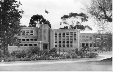 University of Melbourne, Burnley Campus Archives
Photograph - Sepia print, Administration Building, c. 1950
A few years after the surrounding beds had been planted. Appears as an illustration in, "Green Grows Our Garden," A.P. Winzenried p 89. Caption reads, "A landscaping challenge. Stark outlines of the building are gradually softened by foliage."Sepia print. Administration building. 2 students walking behind the Emily Gibson bed.administration building, green grows our garden, a.p. winzenried, planting of surrounding beds, emily gibson, garden design -
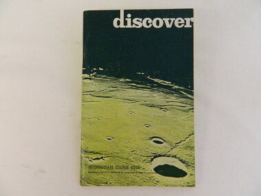 Kiewa Valley Historical Society
Book - Religious Education, Discover by June Wright, Peter Harvey, Robert Evans, 1970
Students attended Sunday School classes at the Kergunyah Presbyterian Church. Sunday school was held in a little 16 foot square wooden building which came from Rocky Valley after it was no longer needed there. Ewen Wallace's father initiated and organised the move. C2011 the building was knocked down because of white ants. The Presbyterian Church will be 125 years old in 2015.Historical: Religious Education: This book was used by students who attended the Sunday School classes at Kergunyah Presbyterian Church. Religion: Presbyterian Church at Kergunyah, in the Kiewa Valley, celebrates its 125th anniversary in 2015 after being handed over to the Uniting Church in the 1970s.Green book with cardboard cover. Dark green at top of book with white block letters, lower case, for title. Lower part of book is light green and depicts moon landscape. Back cover is bright green. 88 pages held by 2 staples.religion, religious education, christian, presbyterian, methodst, churches of christ, congregational churches, anglican, kergunyah, sunday school, ewen wallace -
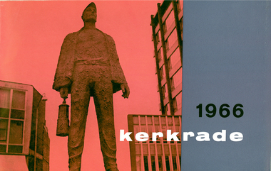 Federation University Historical Collection
Promotional booklet about Kerkrade's music festival, Kerkrade 1966, 1966
Frank Wright was a renown resident of Smeaton, where he was born in 1901. He lived at Laura Villa, and attended Smeaton State School. His father William was a gold miner and his mother's name was Sarah. He was the youngest of eleven children. Their family won many singing and instrumental awards. Frank was tutored by Percy Code and was awarded a gold medal for the highest marks in the ALCM examinations in the British Colonies at the age of seventeen years. He became the Australian Open Cornet Champion by the age of eighteen. A year later, Frank conducted the City of Ballarat Band, and later the Ballarat Soldiers’ Memorial Band. He formed the Frank Wright Frisco Band and Frank Wright and his Coliseum Orchestra. These bands won many South Street awards, and Frank as conductor won many awards in the Australian Band Championship contest. In 1933 Frank Wright sailed to England to conduct the famous St Hilda’s Band and was appointed in 1934 as the Musical Director of the London County Council (the GLC or Greater London Council), where he organized many amazing concerts in most of the 150 parks, in and around the London district. He was also responsible for some of London’s major concerts at Kenwood, the Crystal Palace and Holland Park. He was made Professor of Brass and Military Band Scoring and Conducting and was a Fellow of the Guildhall School of Music and Drama. Frank was often invited to adjudicate Brass Band Championships around Europe, in Australia, including South Street and in New Zealand. Frank was awarded an M.B.E. in 1967 and he died in November 1970. The Frank Wright Medal at the Royal South Street competition is awarded to an individual recognized as making an outstanding contribution to brass music in Australia.Landscape produced with a two toned (red and blue) cover. This booklet contains information, photographs and a map of the venue of the world famous music festival held in the town of Kerkrade in the Netherlands. On one of the pages is a photograph and short bio of Frank Wright who was one of the adjudicators.frank wright, kerkrade, music festival -
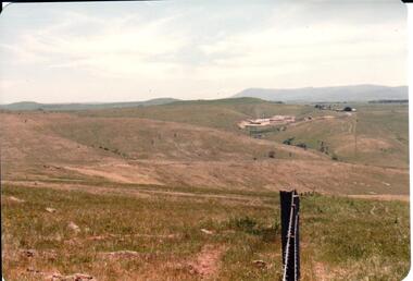 Hume City Civic Collection
Photograph, early 1980s
The Sunbury Tip was transferred from the end of Reservoir Road as housing development spread in that area to a site on the NW side of Mt. Holden near Riddell Road in the early 1980s.A landscape coloured photograph with rounded corners. It is a panoramic view of open country NW of Sunbury near Riddell Road. There is a fence post with barbed wire hanging from it in the immediate foreground and Macedon Ranges and part of the Western Highlands can be seen across the skyline.macedon ranges, mt. macedon, camel's hump, sunbury municipal tip, george evans collection -
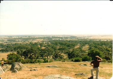 Hume City Civic Collection
Photograph, early 1980s
Gellibrand Hill along with the surrounding 3 properties: Attwood, Cumberland and Woodlands were incorporated into Gellibrand Park during the 1980s. Tullamarine became Melbourne's main air terminal in 1970 and replaced Essendon Airport.A coloured landscape photograph with rounded corners of the Tullamarine Airport taken from Gellibrand Hill. A man with his back to the camera is on the RHS and another person is running down the hill on the LHS. The area in the middle distance is lightly treed and the airport is in the distance to the right of the photograph.gellibrand hill, tullamarine airport, george evans collection -
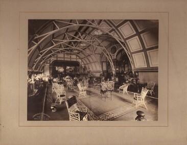 National Trust of Australia (Victoria)
Photograph - Photograph, Black + White, c1903
This photograph informs the viewer of the grand ballroom at Rippon Lea homestead in Elsternwick in the late 1800s. One of 33 rooms in this mansion, built for Fredrick Sargood in 1868, the ballroom stood where the swimming pool is currently located. Louisa Jones’ (nee Nathan) love of the 1930s Hollywood style prompted her to demolish the old ballroom and replace it with the swimming pool. She converted Sargood’s billiard room into a ballroom during the late 1930s. Large black and white photograph (now sepia with age) in a ' landscape format' mounted on cardboard. The room featured in the image has an arched dome-shaped roof, a floor adorned with rugs, a vast and heavily ornate space and approximately 12 wicker chairs in the foreground.Written on verso of mount: 'Ballroom & organ at Rippon Lea' Stamped onto front left bottom corner of photograph: 'Johnstone & O'Shannessy/ & Co./ Propy. Ltd/ Collins St. Melb.' rippon lea, 1890s, ballroom, architecture, decorative arts, sargood family -
Whitehorse Historical Society Inc.
Article, Biography notes City Designers Skills, 1991
Anne Latrielle's new Biography of noted Melbourne Landscape Gardener, the late Ellis Stones,Anne Latrielle's new Biography of noted Melbourne Landscape Gardener, the late Ellis Stones, entitled 'The Natural Garden', contains some fascinating snippets about Nunawading. He had 'innovative' ideas on planting median strips along Springvale and Canterbury Roads.Anne Latrielle's new Biography of noted Melbourne Landscape Gardener, the late Ellis Stones,landscapes, stones, ellis, blackburn and district tree preservation society, latreille anne - the natural garden -
 Whitehorse Historical Society Inc.
Report, A Report on the Development of Yarran Dheran, 1/05/1985 12:00:00 AM
Report by a landscape designer, Paul Thompson, on Yarran Dheran as it was in 1985 and its development in terms of the 1974 master plan. Various areas are discussed in detail. Also includes a summary of the Master Plan. Lists of weeds. Recommendations of appropriate plants for various zones. 22p.yarran dheran, native plants, weeds, parks and reserves -
 Northern District School of Nursing. Managed by Bendigo Historical Society Inc.
Photograph - School 78 Student
School 78 Nr K Dodson in old Library taking book from shelf. 1971 Three Black and white proof photos. Two photos of nurse standing at library shelf with book in hand - landscape. One photo portrait with nurse standing a library shelf taking book from shelf in Old Library 1971 - Nr K Dodson.Numbered on back 7014 - 23,31,34. Names and details on backnursing history, nursing training -
 South Gippsland Shire Council
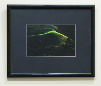
Painting, Oil, Corner Inlet, 1988
Framed oil painting featuring a coastal landscape titled: "Corner Inlet" by B. M. Casey. Set in light brown textured vinyl window mount with gold edging. Engraved brass plaque lower edge. Brown and gold painted wood frame. -
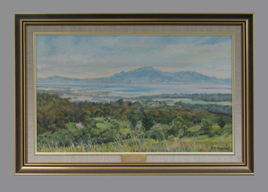
 South Gippsland Shire Council
Photograph, colour, Last Light at Mount Best, 2006
Framed colour photograph titled " Last Night at Mount Best" The landscape features a red building in the centre of green rolling hills. Black card window mount. Glossy black timber frame. Two gold screws with nylon hanging cord on back . -
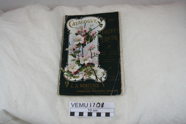 Emerald Museum & Nobelius Heritage Park
Book, Catalogue of Fruit Trees 1915 C.A. Nobelius Nurseryman, Gembrook Nurseries, Emerald, Victoria, Australia, 1915
This is the twenty fourth catalogue of trees and it contains fruit trees, nut trees, berries and some ornamental trees. Carl Nobelius wrote in his General Remarks that he had one million trees to sell, clean, healthy and pest free. The nurseries were 250 acres in extent and contained two and a half million trees in various stages. His nurseries were at Emerald, Railway Siding and his office half a mile from Emerald Railway Station. He imported new varieties from overseas and the nursery was the largest in the Southern Hemisphere, employing 80 people between 1903 and 1930.Green Catalogue 1915 of Fruit Trees, also Elms, Oaks, Planes, Poplars and other Deciduous and Ornamental Trees. The catalogue contains 5 black and white prints of landscape views of the nursery, plus there are 5 bright colour inserts of individual pears and apples.nobelius -
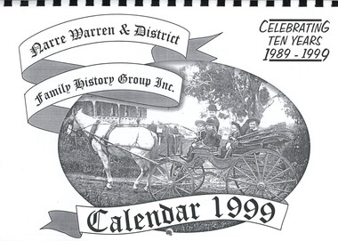 Narre Warren and District Family History Group
Booklet, Narre Warren & District Family History Group Inc, Narre Warren & District Family History Group Inc. Calendar 1999. Celebrating ten years. 1989 - 1999, 1998
1999 printed calendar (black and white) with photos of Narre Warren, Narre Warren North, Berwick, Beaconsfield, Harkaway and Hallam from the collections of Max Thomson and Pam Sweeting.1999 A4 (landscape) calendar with a two page spread each month, historic photo of area on top and calendar month on bottom. Black plastic comb binding, with acrylic cover sheet. Photo of Mrs Kent with 4 of her children and their governess in a carriage. non-fiction1999 printed calendar (black and white) with photos of Narre Warren, Narre Warren North, Berwick, Beaconsfield, Harkaway and Hallam from the collections of Max Thomson and Pam Sweeting.narre warren & district family history group, fred hall, james bailey, charles knell, narre warren state school no. 2924, anniversary calendar -
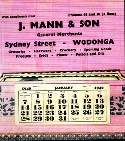 Wodonga & District Historical Society Inc
Ephemera - Calendars - Mann of Wodonga, Various
J. Mann and Sons was first established as a farm produce store in 1921. The range of products was extended in the 1930s and included groceries and hardware, as well as the first petrol bowser in Wodonga outside the store. After WWII, the premises were extended and the range of products continued to increase. In the 1960s the Mann Family opened a new supermarket in Wodonga, in addition to the hardware business, providing steel, plumbing and industrial supplies, and they employed over 100 people at one stage. With changes in the retail industry, the Mann Family sold the main hardware business to Bunnings and the steel and rural produce business to the Kelly brothers in 2006.These calendars are significant as they were produced for a prominent Wodonga business which served the community for 85 years.Three different calendars were produced for Mann of Wodonga. The calendars are for 1940, 1941 and 1969. The first two calendars are a single page whilst the 1969 calendar features two months per page. The 1941 and 1969 calendars feature images of international landscapes.j. mann & sons, mann wodonga -
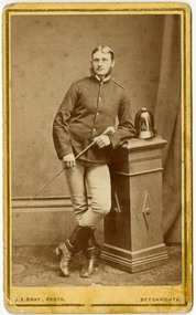 Victoria Police Museum
Carte de Visite (Constable Fitzpatrick), Carte de visite Alexander Fitzpatrick
Constable Alexander Fitzpatrick had a questionable character even before being posted to Greta Police Station in 1878. He made an attempt to arrest Dan Kelly but did not follow correct procedure. He went by himself and had also been drinking beforehand. While Fitzpatrick stated that he was assaulted and suffered a minor gun show wound at the hands of "Ned" Kelly and other family members, his claims were disputed by them. The Kellys "went bush" after this incident and two police parties - one led by Michael Kennedy - were sent in pursuit of them.Sepia toned photograph on cardboard showing Constable Alexander Fitzpatrick holding a riding crop with left elbow resting on a pillar."J.E. Bray, Photo Beecworth" (underneath photograph). "Portrait & Landscape Photographer J.E. Bray Beecworth, Victoria. Negatives kept, copies 1/. each, may be had by forwarding name and address accompanied with remittance to the amount of the order. Photographs coloured in water colours" (on reverse of carte de visite)alexander fitzpatrick, edward kelly, ned kelly, kelly gang, arrest, greta police station, 1878, bushrangers, carte de visite, bray, beechworth