Showing 6909 items
matching photography-cameras
-
 Bendigo Military Museum
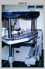
Photograph - Orthorectification Equipment - Army Survey Regiment, Fortuna, Bendigo, c1975, c1988
Orthophoto mapping provided the Survey Corps with the capability to produce map products quickly in the event of a crisis. These are four photographs of equipment used by the Army Survey Regiment to produce orthophotomaps. The Wild GZ1 orthophoto projector shown in photo.1P was introduced in 1973 and was the first equipment used to orthorectify colour and monochrome film aerial photography. Height profiles were originally produced on a PEB8 Stereo profiler and later were software generated. Photos of the PEB8 are available in Victorian Collections item 6222.17P, photos .5P and .6P. In the same era the IBM 1130 computer; OMI/Nistri AP/C-3 analytical plotter with coordinatograph, OP/C orthophoto projector and Zeiss Planimat D2 stereoplotters were introduced. Orthorectification is the process of removing geometric distortions and scale errors/variations from images. Images have tilt and relief distortions that make it difficult to compare accurately a map and an image of the same geographic area. Once an image is orthorectified, features on the image are shown in their planimetric locations. The WILD OR1 orthophoto projector and workstation shown in photos .2P to.4P was introduced in the mid-1980s. It was the second-generation equipment used to orthorectify colour and monochrome film aerial photography, replacing the system introduced in 1973. See items 6124.5P and 6133.4P for more photographs of orthorectification equipment.These four photographs of orthorectification equipment were taken at the Army Survey Regiment at Fortuna, Bendigo, c1975 and c1988. The photos are on 35mm colour slides and scanned at 96 dpi. They are part of the Army Survey Regiment’s Collection. .1) - Photo, colour, c1975, Wild GZ1 orthophoto projector. .2) - Photo, colour, c1988, WILD OR-1 unrectified colour photo in carrier, orthorectified and re-scaled colour image. .3) & .4) - Photo, colour, c1988, WILD OR-1 Orthorectification Workstation.1P to .4P – Some of the equipment is annotated on the frame of the 35mm slides.royal australian survey corps, rasvy, army survey regiment, asr, army svy regt, fortuna -
 Eltham District Historical Society Inc
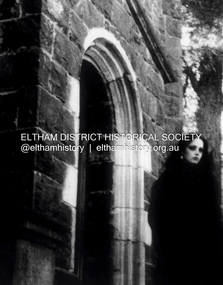
Photograph - Digital Photograph, Rhys Humphries, The Countess, 2023
Photo was taken on a Pentax k1000 on 35mm B&W film. And burned and dodged in the darkroom with a filter of 5 layered on filter 2. Montsalvat Youth Photography Prize 2023 The Montsalvat Youth Photography Competition 2023 was opened to young people aged 14 - 18, based in Victoria. Entrants were invited to explore the grounds, buildings, people, and activities of Montsalvat – to capture its essence and bring their own imagination to the process. First Prize: $1000 sponsored by Future Leaders The winner’s work printed and framed by Montsalvat for display in the Barn Gallery for a three-week exhibition slot. Second Prize: $500 Ten artists were shortlisted and placed on rotational display on Montsalvat’s website and screened in the Barn Gallery for a three-week digital exhibition. In sponsorship with Eltham District Historical Society, the shortlisted works were also to be catalogued and preserved, providing a permanent display of work for young photographers. KEY DATES: Entries opened: Monday the 3rd of April 2023 Entries closed: Friday 8th September - Midnight Finalists advised: Friday 15th September The winners were formally awarded their prize at Montsalvat on Sunday, October 8, 2023. The winners: • 1st place – Yirong Huang Enliven • 2nd place - Rhys Humphries, The Countess • 3rd Place- Jemimah Lavis Windowmontsalvat youth photography prize 2023, montsalvat, second place, emilion clark -
 Ballarat Tramway Museum
Photograph - Black & White Photograph/s - set of 2, State Electricity Commission of Victoria (SECV), 1945?
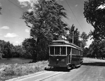
Yields information about one of the first two maximum traction bogie trams in Ballarat in October 1945 after it had been repainted for use in Ballarat by the SEC and the Lake / depot area at the time.Black and white photograph of SEC No. 15 in Wendouree Parade just to the south of St. Aidans Drive. Photo taken looking south with the trolley pole to the camera in the raised position. Appears to be a new trolley rope. Tram has destination of "Gardens via Drummond Nth". Possibly taken soon after receipt and repainting in Ballarat in 1945. "The Ballarat Tramways" notes that No. 15 arrived in Ballarat October 1945 and was renumbered to No. 36 in 1953. Print made by John Phillips c1995. Print used in the interpretation panel at Gardens Loop - believed to be an SEC photo. 2135.1 - as above by wider to the left, shows more the lake. Added 13/4/2009. See The Ballarat Tramways. Additional large print added 21/3/2021.2135.1 - on rear "Delivered from Melbourne in 1945" "Car 15, renumbered 36 in 1953 in order to consolidate the bogie cars from car 34 onwards." and "William F Scott:" address label.tramways, trams, wendouree parade, bogie trams, tram 15 -
 Bayside Gallery - Bayside City Council Art & Heritage Collection
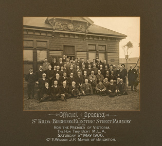
Photograph - sepia photograph, Official Opening, St Kilda - Brighton Electric Street Railway, 1906
electric street railway, public transport, st kilda, brighton, mayor, councillors, thomas bent, premier, opening, celebration, cr. t. wilson, cr. h.b. gibbs, hon. d.e. mcbryde, mr goddard, mr j.n. browne, town clerk, mr bradford, electrical engineer, mr tait, railways commissioner, hon. j.c. campbell, mr rees, mr r.g. mccutcheon, sepia, photograph, tram -
 Kew Historical Society Inc
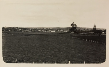
Photograph - Farmland, near Bruthen or Swan Reach, 1926
Henry Beater Christian (1886-1962) , was a descendant of one of the earliest settler families in Kew. Employed at the Kew Asylum as a 'public servant', he was a skilled amateur photographer, photographing numerous scenes in Kew and on his travels around Victoria. The majority of his photographs date from 1916 to 1929. His finest photographs are housed in two photograph albums. Digital copy of a photograph from page 31 of the 47-page photograph album containing 261 gelatinous silver images, loaned by Diane Washfold with permission given to digitise and hold a copy in our collection. John Chapman has written in 'Bushwalking Clubs - A Brief History', about the establishment in Victoria of the first bushwalking club in 1888, and the popularisation of bushwalking during the interwar period. Henry Christian's 'walks' appear to have been undertaken solely or with a companion/s. This black and white photo is part of a group of six photos taken on an 18 kilometre walking trip between Bruthen and Swan Reach in East Gippsland in 1926. The route of the walk followed the Tambo River. The photographer focusses the camera view on the township in the distance with farms in the foreground."BRUTHEN TO SWAN REACH 1926"henry beater christian (1886-1962), landscape photography, christian-washfold collection, photograph albums, bushwalking, bruthen, swan reach, tambo river, east gippsland -
 Melbourne Tram Museum
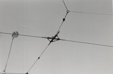
Photograph - Set of 4 Black & White Photograph/s, Keith Kings, about 6/1977
Set of 4 black and white photographs of MMTB trialling overhead fittings for pantographs on the West Preston line. .1 - dummy fitting of where two overhead trolley wires cross each other at 90 degrees .2 - cross frog and signal contactor .3 - Section insulators with pantograph pan depression bars .4 - ears fitted to a curve section with a short dropping sections. Handwritten note (filed with photos) giving photo numbers, location and that sent to ET. Not dated as such. Electric Traction magazine issues for June and August 1977 - see image i5 an it advises of the pantograph trials and changes made. W2 546 had been fitted during May 1977 with a pantograph and a closed circuit camera.trams, tramways, mmtb, west preston, overhead, electrical engineering, electric traction, pantographs -
 Federation University Historical Collection
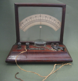
Ammeter, Henry Sutton (probably), Ammeter attributed to Henry Sutton, 1883 (estimated)
W.B Withers wrote of Sutton: "In the realm of science Ballarat has become of world-wide fame through the inventions by Mr Henry Sutton, a native of the place. His skill and acquirements in electricity, telegraphy, telephony, photography and also in astronomical and microscopal studies have won for him a high position as a practical scientist, and the credit is the greater as he is a self-taught student … Mr Sutton, before he was fourteen years old, had read every book on science to be found in the library of the Ballarat Mechanics' Institute." The Ballarat School of Mines (SMB) was fortunate to have this genius appointed as the lecturer-in-charge of the new Electricity and Magnetism department from 23 April 1883. Although Henry Sutton submitted his resignation to the Council of SMB in October 1884 it was resolved that he be asked to reconsider, and Mr Sutton continued to teach at SMB until the end of 1886. He was a prominent member of the Camera Club, and many of the other SMB clubs. Sutton had an active and fertile brain, and was known for his inventions, especially his work on the telephone, telephane and carbon lamps. Sutton presented a vacuum pump, worked by water jet, for use in SMB Chemistry classes. His report of 1883 states: ‘A telephonic circuit has been laid down between the [SMB] engine-house and workshops, to be used for experimental purposes.’ Henry Sutton spent much thought on artificial flight, and made some interesting experimental studies with flying birds. The storage of electricty also attracted his attention, and, after much work and thought evolved the Sutton Secondary Battery. A paper on this battery was presented to the Royal Society, London, and was afterwards printed in the 'Transactions'. Henry Sutton is listed on the Federation University Honour Roll at https://www.federation.edu.au/curator/honour-roll/honourroll_sutton.shtmlA crude scientific instrument that measures amps, with a timber base and frame. Terminal posts and sliders contacts are positioned on top of the base, with flex attached. Henry Sutton lectured at the Ballarat School of Mines (SMB) in Electricty and Magnestism between 1883 and 1886. In 1883 Sutton reported: ‘…The class has been unfortunately situated, by having to wait for instruments of precision ordered from England, but which have not come to hand. The delay has caused us to start constructing instruments, which it is hoped will bear favourable comparison with those of older date.'ammeter, henry sutton, electrical, inventor, electricity and magnetism, sutton, scientific instruments -
 Eltham District Historical Society Inc
Photograph - Aerial Photograph, Landata, Eltham / Research, Vic, Jan. 1951
Centred on Brinkkotter Road opposite Yarramie Reserve, Eltham bounded by Maroondah Aqueduct to north, Nyora Road to south, Eltham College to east and Leane Drive to west. Historic Aerial Imagery Source: Landata.vic.gov.au Aerial Photo Details: Project No :65 Project : MELBOURNE AND METROPOLITAN PROJECT NO. 2 Run : 7 Frame : 8 Date : 01/1951 Film Type : B/W Camera : EAG9 Flying Height : 12200 Scale : 12000 Film Number : 1419 GDA2020 : 37°42'32"S, 145°10'41"E MGA2020 : 339408, 5824924 (55) Melways : 22 F3 (ed. 42)Historical aerial photos and photo maps provide viusal evidence of the chronology of changes to the built landscape of the district and assist in dating other imagesaerial photo, 1951-01, eltham, neil webster collection, brinkkotter road, eltham college, leane drive, maroondah aqueduct, melways 22f3, nyora road, yarramie reserve -
 Eltham District Historical Society Inc
Photograph - Aerial Photograph, Landata, Eltham, Vic, Jan. 1951
Centred on Beard Street between Main Road and Frank Street, Eltham bounded by Maroondah Aqueduct to north, Arthur Street to south, Maroong Drive to east and Catholic Ladies College to west. Historic Aerial Imagery Source: Landata.vic.gov.au Aerial Photo Details: Project No :65 Project : MELBOURNE AND METROPOLITAN PROJECT NO. 2 Run : 7 Frame : 9 Date : 01/1951 Film Type : B/W Camera : EAG9 Flying Height : 12200 Scale : 12000 Film Number : 1419 GDA2020 : 37°42'23"S, 145°09'39"E MGA2020 : 337874, 5825170 (55) Melways : 22 B3 (ed. 42)Historical aerial photos and photo maps provide viusal evidence of the chronology of changes to the built landscape of the district and assist in dating other imagesaerial photo, 1951-01, eltham, neil webster collection, arthur street, beard street, catholic ladies college, frank street, main road, maroondah aqueduct, maroong drive, melway 22b3, research (vic.) -
 Eltham District Historical Society Inc
Photograph - Aerial Photograph, Landata, Eltham North, Feb. 1956
Centred on present day 54 Kelway Crescent, Eltham North bounded by Glen Gully Road to north, Meruka Drive to south, Eltham College to east and Leach Street to west. Historic Aerial Imagery Source: Landata.vic.gov.au Aerial Photo Details: Project No :250 Project : MELBOURNE OUTER SUBURBS PROJECT Run : 17 Frame : 113 Date : 02/1956 Film Type : B/W Camera : EAG9 Flying Height : 10000 Scale : 12000 Film Number : 1176 GDA2020 : 37°42'16"S, 145°08'08"E MGA2020 : 335650, 5825336 (55) Melways : 21 G2 (ed. 42)aerial photo, 1956-02, eltham, eltham north, glen gully road, leach street, main road, melway 21g2, meruka drive, montmorency, neil webster collection -
 Eltham District Historical Society Inc
Photograph - Aerial Photograph, Landata, Montmorency, Feb. 1956
Centred on present day Tahlee Place Reserve and Sherbourne Preschool, Montmorency bounded by Progress Road to north, Withers Way to south, Main Road to east and Leach Street to west. Historic Aerial Imagery Source: Landata.vic.gov.au Aerial Photo Details: Project No :250 Project : MELBOURNE OUTER SUBURBS PROJECT Run : 17 Frame : 114 Date : 02/1956 Film Type : B/W Camera : EAG9 Flying Height : 10000 Scale : 12000 Film Number : 1176 GDA2020 : 37°42'50"S, 145°08'02"E MGA2020 : 335512, 5824286 (55) Melways : 21 F5 (ed. 42)aerial photo, 1956-02, neil webster collection, central park, eltham, leach street, main road, melway 21f5, montmorency, progress road, withers way, sherbourne preschool, tahlee place reserve -
 Eltham District Historical Society Inc
Photograph - Aerial Photograph, Landata, Lower Plenty, Feb. 1956
Centred on present day 217 Old Eltham Road, Lower Plenty bounded by Pitt Street to north, Yarra River to south, Main Road to east and Bonds Road to west. Historic Aerial Imagery Source: Landata.vic.gov.au Aerial Photo Details: Project No :250 Project : MELBOURNE OUTER SUBURBS PROJECT Run : 17 Frame : 116 Date : 02/1956 Film Type : B/W Camera : EAG9 Flying Height : 10000 Scale : 12000 Film Number : 1176 GDA2020 : 37°43'58"S, 145°07'49"E MGA2020 : 335237, 5822186 (55) Melways : 21 E10 (ed. 42)aerial photo, 1956-02, neil webster collection, eltham, main road, bonds road, elham, lower plenty, melway 21e10, pitt street, yarra river -
 Eltham District Historical Society Inc
Photograph - Aerial Photograph, Landata, Eltham, Feb. 1956
Centred on present day Shalbury Avenue, Eltham bounded by Leane Drive and Parsons Road to north, Nyora Road to south, Reynolds Road to east and the Diamond Creek to west Historic Aerial Imagery Source: Landata.vic.gov.au Aerial Photo Details: Project No :250 Project : MELBOURNE OUTER SUBURBS PROJECT Run : 18 Frame : 95 Date : 02/1956 Film Type : B/W Camera : EAG9 Flying Height : 10000 Scale : 12000 Film Number : 1176 GDA2020 : 37°41'57"S, 145°09'51"E MGA2020 : 338145, 5825965 (55) Melways : 22 C1 (ed. 42)aerial photo, 1956-02, neil webster collection, eltham, diamond creek (creek), melway 22c1, nyora road, parsons road, reynolds road, shalbury avenue -
 Eltham District Historical Society Inc
Photograph - Aerial Photograph, Landata, Research, Vic, Feb. 1956
Centred on present day Thompson Crescent, Research bounded by Maroondah Aqueduct to north, Thompson Crescent and Nyora Road to south, Bells Hill Road to east and Eucalyptus Road to west Historic Aerial Imagery Source: Landata.vic.gov.au Aerial Photo Details: Project No :250 Project : MELBOURNE OUTER SUBURBS PROJECT Run : 19 Frame : 6 Date : 02/1956 Film Type : B/W Camera : EAG9 Flying Height : 10000 Scale : 12000 Film Number : 1176 GDA2020 : 37°42'38"S, 145°11'02"E MGA2020 : 339927, 5824736 (55) Melways : 22 H4 (ed. 42)aerial photo, 1956-02, neil webster collection, bells hill road, eltham, eucalyptus road, maroondah aqueduct, melway 22h4, nyora road, research (vic.), thompson crescent -
 Eltham District Historical Society Inc
Photograph - Aerial Photograph, Landata, Research, Vic, Apr. 1963
Centred on present day Thompson Crescent and Nicholson Close, Research bounded by Maroondah Aqueduct to north, Nyora Road to south, Eltham College to east and Eltham Gateway Hotel to west. Historic Aerial Imagery Source: Landata.vic.gov.au Aerial Photo Details: Project No :486 Project : MELBOURNE (1963) PROJECT Run : 5 Frame : 61 Date : 04/1963 Film Type : B/W Camera : RC8 Flying Height : 5100 Scale : 9600 Film Number : 1805 GDA2020 : 37°42'24"S, 145°10'06"E MGA2020 : 338528, 5825143 (55) Melways : 22 D3 (ed. 42)aerial photo, neil webster collection, eltham, 1963-04, eltham college, eltham gateway hotel and conference centre, maroondah aqueduct, melway 22d3, nicholson close, nyora road, research (vic.), thompson crescent -
 Eltham District Historical Society Inc
Photograph - Aerial Photograph, Landata, Eltham, Vic, Apr. 1963
Centred on present day John Street, Eltham between Main and Bible streets bounded by Elsa Court to north, Main Road Bridge to south, Wattle Grove to east and Bolton Street to west. Historic Aerial Imagery Source: Landata.vic.gov.au Aerial Photo Details: Project No :486 Project : MELBOURNE (1963) PROJECT Run : 6 Frame : 123 Date : 04/1963 Film Type : B/W Camera : RC8 Flying Height : 5100 Scale : 9600 Film Number : 1805 GDA2020 : 37°43'12"S, 145°08'54"E MGA2020 : 336800, 5823623 (55) Melways : 21 J6 (ed. 42)aerial photo, neil webster collection, 1963-04, bolton steet, elsa court, eltham, john street, main road, main road bridge, melway 21j6, wattle grove -
 Eltham District Historical Society Inc
Photograph - Aerial Photograph, Landata, Eltham, Vic, Apr. 1963
Centred on present day Eltham Ridge, Bolton Street, Eltham bounded by Elsa Court to north, Main Road to south, Bible Street to east and Reichelt Avenue and Rattray Road to west. Historic Aerial Imagery Source: Landata.vic.gov.au Aerial Photo Details: Project No :486 Project : MELBOURNE (1963) PROJECT Run : 6 Frame : 124 Date : 04/1963 Film Type : B/W Camera : RC8 Flying Height : 5100 Scale : 9600 Film Number : 1805 GDA2020 : 37°43'12"S, 145°08'16"E MGA2020 : 335876, 5823604 (55) Melways : 21 G6 (ed. 42)aerial photo, neil webster collection, 1963-04, bible street, bolton street, eltham, eltham ridge, main road, montmorency, rattray road, reichelt avenue -
 Eltham District Historical Society Inc
Photograph - Aerial Photograph, Landata, Eltham, Vic, Apr. 1963
Centred on present day Griffith Park Road, Eltham bounded by Mount Pleasant Road to north, Yarra River and Templestowe to south, Main Road at Reynolds Road to east and Falkiner Street to west. Historic Aerial Imagery Source: Landata.vic.gov.au Aerial Photo Details: Project No :486 Project : MELBOURNE (1963) PROJECT Run : 7 Frame : 233 Date : 04/1963 Film Type : B/W Camera : RC8 Flying Height : 5100 Scale : 9600 Film Number : 1805 GDA2020 : 37°44'04"S, 145°09'10"E MGA2020 : 337237, 5822053 (55) Melways : 22 A10 (ed. 42)aerial photo, neil webster collection, 1963-04, eltham, falkiner street, griffith park road, melway 22a10, mount pleasant road, reynolds road, templestowe, yarra river -
 Eltham District Historical Society Inc
Photograph - Aerial Photograph, Landata, Eltham, Vic, Apr. 1972
Centred on present day Zig Zag Road near Coolabah Drive, Eltham bounded by Allendale Road to north, Park West Road to south, Parsons Road to east and Banks Road to west. Historic Aerial Imagery Source: Landata.vic.gov.au Aerial Photo Details: Project No :985 Project : MELBOURNE 1972 Run : 26 Frame : 191 Date : 04/1972 Film Type : B/W Camera : RC10 Flying Height : 5700 Scale : 9600 Film Number : 2636 GDA2020 : 37°41'56"S, 145°09'26"E MGA2020 : 337533, 5826000 (55) Melways : 22 A1 (ed. 42)aerial photo, neil webster collection, 1972-04, allendale road, eltham, eltham north, zig zag road, banks road, coolabah drive, melway 22a1, park west road, parsons road -
 Eltham District Historical Society Inc
Photograph - Aerial Photograph, Landata, Eltham, Vic, Apr. 1972
Centred on present day Parsons Road, Eltham bounded by Allendale Road to north, Frank Street to south, Research Shops and Raglan Road to east and Zig Zag Road to west. Historic Aerial Imagery Source: Landata.vic.gov.au Aerial Photo Details: Project No :985 Project : MELBOURNE 1972 Run : 26 Frame : 192 Date : 04/1972 Film Type : B/W Camera : RC10 Flying Height : 5700 Scale : 9600 Film Number : 2636 GDA2020 : 37°42'00"S, 145°09'59"E MGA2020 : 338360, 5825897 (55) Melways : 22 D1 (ed. 42)aerial photo, neil webster collection, 1972-04, allendale road, eltham, zig zag road, frank street, melway 22d1, parsons road, raglan road, research (vic.), research shops, eltham barrel -
 Eltham District Historical Society Inc
Photograph - Aerial Photograph, Landata, Eltham, Vic, Apr. 1972
Centred on present day Woodridge Estate, Eltham bounded by Park Road to north, Mount Pleasant Road to south, Stokes Orchard Estate to east and Eltham Railway Station to west. Historic Aerial Imagery Source: Landata.vic.gov.au Aerial Photo Details: Project No :985 Project : MELBOURNE 1972 Run : 27 Frame : 46 Date : 04/1972 Film Type : B/W Camera : RC10 Flying Height : 5700 Scale : 9600 Film Number : 2636 GDA2020 : 37°42'49"S, 145°09'46"E MGA2020 : 338053, 5824365 (55) Melways : 22 C5 (ed. 42)aerial photo, neil webster collection, 1972-04, eltham, eltham railway station, melway 22c5, mount pleasant road, park road, stokes orchard estate, woodridge estate -
 Eltham District Historical Society Inc
Photograph - Aerial Photograph, Landata, Eltham, Vic, Apr. 1972
Centred on present day Main Road at Pryor Street, Eltham bounded by Park West Road to north, Napoleon Street to south, Woodridge Estate to east and Ryans Road to west. Historic Aerial Imagery Source: Landata.vic.gov.au Aerial Photo Details: Project No :985 Project : MELBOURNE 1972 Run : 27 Frame : 47 Date : 04/1972 Film Type : B/W Camera : RC10 Flying Height : 5700 Scale : 9600 Film Number : 2636 GDA2020 : 37°42'45"S, 145°09'12"E MGA2020 : 337223, 5824470 (55) Melways : 22 A4 (ed. 42)aerial photo, neil webster collection, 1972-04, eltham, eltham railway station, woodridge estate, eltham shops, main road, melway 22a4, napoleon street, park west road, pryor street, ryans road -
 Eltham District Historical Society Inc
Photograph - Aerial Photograph, Landata, Eltham, Vic, Apr. 1972
Centred on present day Dalton Street at Mount Pleasant Road, Eltham bounded by Arthur Street to north, Yarra River and Kent Hughes Road to south, Eucalyptus Road to east and Susan Street to west. Historic Aerial Imagery Source: Landata.vic.gov.au Aerial Photo Details: Project No :985 Project : MELBOURNE 1972 Run : 28 Frame : 208 Date : 04/1972 Film Type : B/W Camera : RC10 Flying Height : 5700 Scale : 9600 Film Number : 2635 GDA2020 : 37°43'29"S, 145°08'54"E MGA2020 : 336816, 5823118 (55) Melways : 21 J8 (ed. 42)aerial photo, neil webster collection, 1972-04, eltham, arthur street, dalton street, eucalyptus road, kent hughes road, melway 21j8, mount pleasant road, susan street, yarra river -
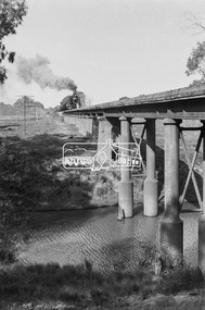
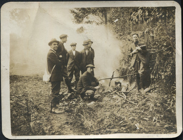
 Eltham District Historical Society Inc
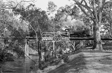
Photograph, Steam locomotive K-158 crossing the railway bridge over the Campaspe River at Rochester, Victoria, c.November 1963, 1963
It is the railway bridge over the Campaspe River at Rochester, Vic. original to the construction of the line. It was taken late on a Saturday morning and shows the regular goods train of that period approaching, then crossing the bridge. I originally planned to take just one view. The approaching train was first then it was a rapid run back along the raised river bank to get the broadside shot. I had little time to steady myself or properly check camera settings, hence the slightly soft focus etc. The train would eventually continue over the Echuca Iron Bridge into NSW. I think its ultimate destination was Deniliquin but not sure.Digital TIFF file Scan of 35mm Ilford FP3 black and white negative transparencygeorge coop collection, k-158, k-class steam locomotive (vr newport workshops), railway bridge, campaspe river, rochester -
 Eltham District Historical Society Inc
Photograph, Steam locomotive K-158 crossing the railway bridge over the Campaspe River at Rochester, Victoria, c.November 1963, 1963
It is the railway bridge over the Campaspe River at Rochester, Vic. original to the construction of the line. It was taken late on a Saturday morning and shows the regular goods train of that period approaching, then crossing the bridge. I originally planned to take just one view. The approaching train was first then it was a rapid run back along the raised river bank to get the broadside shot. I had little time to steady myself or properly check camera settings, hence the slightly soft focus etc. The train would eventually continue over the Echuca Iron Bridge into NSW. I think its ultimate destination was Deniliquin but not sure.Digital TIFF file Scan of 35mm Ilford FP3 black and white negative transparencygeorge coop collection, k-158, k-class steam locomotive (vr newport workshops), railway bridge, campaspe river, rochester -
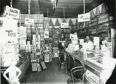 Surrey Hills Historical Society Collection
Photograph, Inside Bill Whittingham's grocery shop, 144 Union Road, 1930
Copied from a glass negative; original photo taken by Ian Barkla's father, Frank Leslie Barkla of 37 Grovedale Road. He was a keen amateur photographer and member of the Melbourne Camera Club. There is also a copy by Ken Hall. Date is approximate. The shops between Croydon and Guildford Road were built at the end of the 1920s and occupied immediately. Next north of Whitty's was H Wichell (bootmaker at 146), J T Poynton (butcher at 148), Mrs A Wardell (confectioner at 150), R J Skinner (grocer at 152), W Ives (fruit and vegetables at 154) and W R Latchford (hardware at 156). Black and white photo of the interior of Bill Whittingham's grocery shop at 144 Union Road, Surrey Hills. There is a counter on the RHS behind which there is a man in a white coat. The counter is stacked at one end with goods and at the other there is a glass case. The shelves at the rear of the shop are stacked high and there are multiple advertising signs, including ones for Perservene soap, Ovaltine, Bourn-vita cocoa and Brockhoff biscuits.Label: "I R Barkla. Collection / Location SURREY HILLS / Date ....... / Neg. No 284"whitty's, advertising, shops, grocers, businesses, union road shops, bill whittingham, frank leslie barkla -
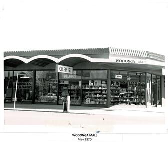 Wodonga & District Historical Society Inc
Photograph - Codling Collection 01 - Wodonga Mall and construction
Miss Olive Codling was a Foundation Member and a Life Member of the Wodonga Historical Society. Many of her prize-winning photos are held in the Society Collection. She also held a range of roles and committee positions in a wide range of Wodonga community organisations. These included the Horticultural Society, the Wodonga Arts Council, the Wodonga Camera Club and the Wodonga Lapidary Club. As the population of Wodonga grew in the late 1960s and 1970s, development focussed on the central section of High Street. The Wodonga Mall was built in 1969 on the corner of Stanley and High Streets in Wodonga and was the location of a variety of small businesses including a chemist and Sarroff's Dry Cleaners.This photo collection is significant as it documents how the businesses and buildings in Wodonga have evolved and contributed to the community throughout the 20th century. A series of 3 black and white photos showing the development of the Wodonga Mallwodonga businesses, high st wodonga, melba theatre -
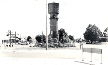 Wodonga & District Historical Society Inc
Photograph - Codling Collection 01 - Water Tower, High Street, 1980
Miss Olive Codling was a Foundation Member and a Life Member of the Wodonga Historical Society. Many of her prize-winning photos are held in the Society Collection. She also held a range of roles and committee positions in a wide range of Wodonga community organisations. These included the Horticultural Society, the Wodonga Arts Council, the Wodonga Camera Club and the Wodonga Lapidary Club. Elaine Mann was married to David Mann, a successful Wodonga businessman and community leader who passed away in Wodonga in June 2012. David was a member of the Mann family who began their business in Wodonga in 1920. Elaine was a teacher in Wodonga for many years.This photo collection is significant as it documents how the businesses and buildings in Wodonga have evolved and contributed to community throughout the 20th century.THE WATER TOWER is a major landmark of High Street, Wodonga. It began operation from January 1924 until it ceased operation in 1959. It stood unused for a decade until the lower section was modified and put to use as “ The Tower’s Cobbler’s Inn” in 1962. In 1972 Wodonga City Council proposed to demolish the Tower. Their suggestion received an unfavorable response from the city’s citizens, so the Tower still stands today. This image shows High Street and Hovell Street looking to the north The Civic Centre Theatre is on the right in Hovell Street. On the left in High Street is Tower Place on left. On the far left Repco which by 1998 became a Chinese restaurant and remains so in 2021.wodonga businesses, high st wodonga, water tower, hovell street wodonga, high street wodonga -
 City of Moorabbin Historical Society (Operating the Box Cottage Museum)
Photograph, postcard "Boiling the Billy" c1900, Early 1900's "Boiling the Billy", c1900
Early 1900's. "Boiling the billy". The term billy or billycan is particularly associated with Australian usage, but is also used in the UK and Ireland. It is widely accepted that the term "billycan" is derived from the large cans used for transporting bouilli or bully beef on Australia-bound ships or during exploration of the outback, which after use were modified for boiling water over a camp fire. Postcards developed out of the complex tradition of nineteenth-century printed calling cards, beginning with the advent of the Cartes-de-Visite in France. In the 1850s, Parisian photographer Andre Adolphe Eugene Disderi invented a photographic process involving egg white, albumen, and silver nitrate to create inexpensive portraits on paper cards. These photographic Cartes-de-Visites were 2 1/2 (75mm) by 4 inches (98mm) and became a popular, collectable form of "visiting cards" world-wide. Photographers would reprint portraits of famous individuals they had taken at their studios or during travel and sell them as collectable cards. Postcards as we know them now first began in 1861 as cards mailed by private post. In the 1870s picture postcards grew in popularity throughout the United States, Britain, Europe, and Japan. Cards were first permitted to have a "Divided Back," with text written on the left half of a dividing line and the address on the right half, beginning in England in 1902. Around 1900 the first postcards made of "Real Photos" rather than artwork began to circulate, aided in by advances in amateur photography equipment by companies such as Kodak. Kodak also introduced postcard paper for photographic development and photography studios began to offer portraits printed as postcards Many local town, countryside, and architectural images were captured during this period by local photographers, then printed and sold as postcards . Advances in amateur photography all contributed to a postcard craze that lasted from 1900 to the First World War. Postcards were the preferred means to send a quick note, whether across town or across a continent.Postcard with a black and white Photograph on the front and a 'Divided Back ' for the message and address. There are seven men surrounding the billy suspended over a camp fire. The ground has a lot of dead branches around. One man is bending down towards the billy. Two men on either side of the camp fire are carrying either a white bag across their shoulders or the fish in their hands. You can see, that there is some steam also coming out of the billy, which means that its hot. Court Post Card. / this space may be used for correspondence. / The address only to be written here.1900's, boiling the billy , postcards, photographers, england, hungary, america, cartes-de-visite, visiting cards, moorabbin, cheltenham, bentleigh, market gardeners, early settlers, pioneers, -
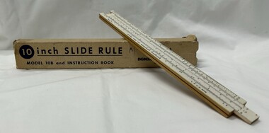 Greensborough Historical Society
Functional object - Ruler, Engineering Instruments, Inc, 10 inch slide rule model 10B and instruction booklet, 1947-1967
George Lee Lawrence (1901–1976) established a firm in Chicago to make slide rules for photography. In 1935 he moved to Wabash, Ind., renamed the company Lawrence Engineering Service, and began to manufacture general purpose slide rules. In 1938 he relocated once more to Peru, Ind., and in 1947 it was changed to Engineering Instruments, Inc., and the company remained in business until its building burned down in 1967. The model 10-B sold for 25 cents during this period. There is no record that Lawrence ever received a patent for any aspect of his design or manufacturing process.Used up to the 1960s prior to the invention of the electronic calculator.10 inch one-sided wooden slide rule painted white on the front face, which consists of two divided scales, one fixed and on movable, and a sliding window called a cursor. A, D, and K scales are on the base, and B, CI, and C scales the inside of the slide. The underside of the rule is marked with: tables for equivalents and conversions. Housed in cardboard box with instruction booklet.The top of the base is marked: MADE IN U.S.A. It is also marked ENGINEERING INSTRUMENTS, INC., PERU, INDIANA and PAT. PEND. Underside: This Famous Slide Rule... at a popular price. Solves Problems in Multiplication, Division, Proportion, Squares Roots, Cubes and Cube Roots, Reciprocals, etc., Instantly. Accurately Calibrated White Face on Well Seasoned Hardwood. Both ends of box: MODEL 10B-BK Price of 15 shillings handwritten on box.slide rule, mathematics