Showing 2027 items matching "station building"
-
 Charlton Golden Grains Museum Inc
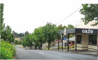
Photograph, Charlton Shire, Lou's Cafe High St Charlton c.1987, c.1987
Lou's Cafe c. 1987. In the 1930s and early 40's it was Riches Cafe and Billiards Saloon. Sold to Halligan's, Duggans, Jerry Cowell until 1951 when Luths took over the building as a Car and Tractor agency. Next door was Bennett's Shoe Repair Shop which was later a Stock & Station Agency. Part of a streetscape series done for the Shire of Charlton c. 1987.Colour photograph of a single storey building. Signage on the windows reads Lou's CAFE and on the awning Lou's MILK Bar. Other signs on the windows read Fresh Fruit VEGS, meals, TAKE AWAY FOOD, FISH & CHIPS, HAMBURGERS. Signs above the awning advertise Pauls Streets and Peters ice creams. Two cars parked in front of shop and a man and a woman are standing beside one of the cars. Drive way to the left of the cafe and a single storey, glass fronted building is on the LH side of the photo. Signs on the windows read Crafts, Haberdashery, Gifts and BAGGAGE. To the right of the cafe is a yellow-green fence.lou's cafe, riches cafe and billiard saloon, halligan, duggan, jerry cowell, business -
 Stawell Historical Society Inc
Photograph, Aerial photo of Stawell Lower Main Street looking towards the Grampians 1950's
Aerial shot 1950's, Caltex Service Station, Cato Lake, War Memorial and Weights Bridge, Salvation Army Building and McClure's used Car yard. -
 Linton and District Historical Society Inc
Photograph, Funeral by Nelson Brothers
Black and white copy of original photograph showing a funeral cortege of horse and carts on a dirt road in front of a large building.nelson funeral, nelson brothers, newport power station, 1922, horses, carriage, buggy -
 Ringwood and District Historical Society
Photograph, R.F. Miles, Sergeant, AIF. c1915
Black and white photograph (2 copies- 1 original, found at "Glamorgan' Ringwood, 1 copy)Written on back of photograph, "R.F. Miles". Additional information is as follows: "R. F. Miles. Raoul Fortescue Miles was one of the seven sons of Captain Edward Thomas Miles and Mrs. Charlotte Eliza Miles. There were also four girls. Names of these in order are: Edward Leslie, Amy Florence, Augustus Temple, Lilian Ethel (Mrs. G.M. Parker), Hilda Clare (Mrs. J.W. Barrett), Arthur Hunter, Thomas Alfred, Sydney Derwent, Raoul Fortescue, Kathleen Mary Edith (Mrs. Howe), Keith Lyttleton. The only survivors are Thomas Alfred and Kathleen Howe. Raoul Miles served in the 12 Bn. in the first AIF and rose to the rank of sergeant. He Married an English girl at the end of 1st World War and brought her as an 18 year old bride to Australia. He worked Hendon which was owned by Captain Miles. In the early twenties he went to Seaford and opened a cafe on Napean Highway. He then opened an estate agency as well in front of his house. He was a councillor in the then Shire of Frankston and Hastings. He was Shire President at some time. Just before the 2nd World War he opened an estate agency in Frankston near the station. He also had a post office agency in the building which he owned. After the war he and his brother Sydney subdivided land and built houses at Seaford. His wife died suddenly and for some years he lived alone in a two storey houses divided into two flats. He died when he was about 72 or 73. During World War 2 he was a recruiting officer for the R.A.A.F. He had five children: - Jean (Mrs. Hayward, Portland?), Barbara (Mrs. Collins, Wattle Park), Laurie (Mrs. Thorpe Woods, Kent, England), Ted, Seaford?, Bill, Seaford?". -
 Lakes Entrance Historical Society
Photograph - Lake Tyers Aboriginal Settlement, 1940
Unidentified children, photograph taken at Lake Tyers Aboriginal Station.Small format black and white photograph four small children, one in pram, church building in background. Lakes Tyers Victoriaaboriginals, lake tyers -
 Port Melbourne Historical & Preservation Society
Photograph, Railway Pier, Melbourne, Victoria, c. 1900
Railway Pier opened in 1852 with the building of the Hobson's Bay Railway linking the city to Port Melbourne. In 1923 in was re-built as Station Pier.Sepia postcard of Railway Pier with shed on left in front of 2 ships . A sailing ship lies on the opposite side below the Finger Pier. A steamer being towed away from the pier by a tug .piers and wharves - railway pier, transport - shipping -
 Melbourne Tram Museum
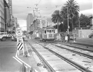
Photograph - Set of two - trackwork Flinders St, 1971
The photographs shows MMTB track renewal work in Flinders St during 1971. The first photo shows W2 tram 408 and a wide body tram behind running while work is being carried out, with several workers standing clear. The second photo shows a replacement cross over installed near Queen St. In the background are Flinders St Station and the Gas and Fuel buildings. Fletcher Jones building is on the left hand side of the second photo.Yields information about undertaking trackwork while running trams and the minimal closing of the roadway to motor traffic.Black and White photograph with photographer's notes on rear"Flinders St 1971" and "Dave Macartney"trams, tramways, trackwork, flinders st, w2 class, tram 408 -
 Charlton Golden Grains Museum Inc
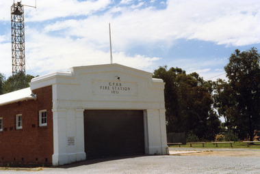
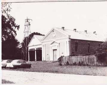
Photograph, Charlton Shire, Charlton Fire Station c. 1987, c.1987
The Charlton Fire Station was built in 1931.Colour photograph of the Charlton Fire Station. A single storey red brick building with a white frontage. A large entrance and three high high windows down the side. There is a plaque on the LH side of the main entrance that can't be clearly read.. The signage above the main entrance reads C.F.B.B. FIRE STATION 1931 There is a light above this sign. The fire tower is at the rear of the building. There is a low railing fence on the right side.charlton fire station, charlton fire brigade, public services -
 Charlton Golden Grains Museum Inc
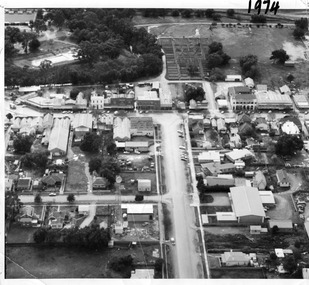
Photograph, Aerial photo of Armstrong St, Charlton, c.1974
Aerial photo looking down Armstrong St. Camp street on the left, Shire Hall on the right. High St runs across the photo. The Avoca River is visible in the top LH side. The swimming pool and bowling green is above the rive. On High St (from L-R) Dr Surgery, H Bath Chemist, Grocery, Roy Dobson, Hairdresser, Stowe's, Westpac Bank (two storey white building), Dillon's Building, Globe Hotel, Charlton Club, butcher shop, Arundell's shoe shop, Watson's Stock & Station Agency, Bullock's grocery, Williams St (Curtin Ave), Bannon's Butchers, East Charlton Hotel, MB Luth & Co, Lou's cafe. The old sale yards are at the end of Williams Street. Camp St lower side (from L-R) Court House, Police residence, Police Station, Telecom on corner. The photo is thought to be taken from Ossie Sanderson's airplane in 1974.Black & white aerial photo looking down a broad street that ends in a t-intersection. There is a street that comes off to the left about 1/3 of the way up the photo. There is a large building directly opposite this street. In the upper right there is a two storey building with arches on its verandah. In the upper LH side there is a swimming pool and bowling greens.armstrong st charlton, charlton, business, industry, westpac bank, globe hotel, east charlton hotel, dillon building -
 Clunes Museum
Photograph
COPY OF PHOTOGRAPH OF CLUNES FIRE BRIGADE BUILDING IN HILL STREET, PRIOR TO THE NEW FIRE STATION IN ALLIANCE STREET.local history, photography, photographs, fire brigade -
 Eltham District Historical Society Inc
Film - Video (VHS), Jenni Mitchell, Demolition of the Shire of Eltham Offices, 1996
Poor video quality (noise and interference), incomplete and unedited raw footage. A video documenting the demolition of the Shire of Eltham offices at 895 Main Road Eltham under the direction of the Commissioners appointed for the new Shire of Nillumbik and some of the communities activities surrounding the event. The building was demolished exactly 25 years after the southern wing housing Engineering and Planning on the upper level and the Eltham Library on the ground level was opened in celebration of the Shire of Eltham's centenary. Video has lots of distortion and noise, and sections of clips dubbed over. Immediate initial footage of Jenni Mitchell talking about asbestos claims in the Shire Offices (Sigmund Jorgensen standing behind her) advising Council did a review of the building several years previously and had been cleared of health problems. Cuts to group of people standing outside front door of offices but possibly voice dub over not related ? Then the date 27 Jul 1996 on a scene flashes on screen immediately followed by an edited clip intro of title and credits with classical music track. It then opens with Jenni Mitchell driving to the Shire Offices on Saturday 27 July 1996 at 11.00am. Footage of Main Road past Pitt Street, Alistair Knox Park then entering Shire Office driveway which is fenced off and contractor signs hanging up. Scenes at rear of building showing some internal demolition has commenced. View of the Administration wing. More clips of road driving, Alistair Knox Park, Eltham Library and visitor car park for Shire Offices. Cuts to a group of people standing in access to visitor carpark with new Eltham Library in background, one being immediate former Shire of Eltham President, John Graves. Scenes of people looking through chain link fence and security guard checking front door. John Graves being filmed that someone informed him the Shire was offering the building to the Community Health Centre for $2.3 million and that if they had been offered a price of $1.1 for what it apparently was sold for they would have snapped it up. View of truck loaded with brick rubble literally struggling to ascend the hill of Library Place to exit into Main Road. Cuts to a scene looking at Eltham War memorial Hall through the Memorial Gate, then the Shillinglaw trees and large banner sign ‘Delta Demolitions’ hanging on office façade. Views of front door, old library and bluestone wall. Scene (31 Jul 1996) filmed at night of several white crosses with “RIP Community” and “RIP Democracy”. Scene (1 August 1996) again driving along Main Road towards the Shire Offices then scenes of the offices showing substantially more demolition to exterior, groups of people standing on footpath outside watching, Delta heavy demolition machines, woman holding sign “Democracy where have you gone …”, the odd person in full protection gear and breathing apparatus hand carrying materials out to place on rubbish pile in front of people standing on footpath watching (with no protection) and then stamping on it to break it creating dust, security person in hard hat (no other protection) wandering around, many groups standing around watching, news film crew, person standing on roadside edge holding signs facing traffic stating “Pirate Planning” and “ Grant us your ears” also sign on back of parked car “Elthams High Jacks”, another sign “Community Democracy”, views of crosses in Main Road median strip “RIP Community”, groups of people on footpaths and reporters conducting interviews, footage of unknown person standing with Jenni Mitchell and Sigmund Jorgensen advising people have the right to protest, Jenni Mitchell urging people to ask questions of local MP and Council and Sigmund Jorgensen referring to the three historic Shillinglaw trees with demolition machinery operating in background, Jenni Mitchell and others installing more crosses in median strip; demolition machines operating inside and outside the building, more views of onlookers including Sigmund Jorgensen then Police approaching on footpath, workers and machinery continuing to operate, views of the old library being demolished, the former Community Services department, security personnel. Scene (2 August 1996) more heavy demolition machinery in operation smashing building up, people standing around southern wing watching, view overlooking Eltham Library of train pulling in to Eltham station. Scene (7 August 1996) more heavy demolition and people wandering around with only hard hat protection, no dust protection, comments from one operator dumping a bin of material stating “wait till there’s a Hungry Jack’s here, you’ll be laughing, fuel, videos, hamburgers. You’ll be up with the rest of the world soon, you’ll have electricity and everything here, ha ha ha ha”, more heavy machinery demolition and breaking up of materials, view of Hitachi train going by and Administration wing, view inside the front door opening of the staircase leading to upper level, person walking around operating heavy machinery with a hose spraying rubble (no protective gear other than hard hat interspersed with edit cuts of meeting of Commissioners and independent observers on panel as well as members of the community in public gallery. Nillumbik Shire CEO Barry Rochford addressing the meeting., Chief Commissioner Don Cordell directly addressing Jenni Mitchell with respect to permission to take photographs, Barry Rochford continues to address the question asked of Council about the valuation of the former Shire of Eltham Office building/site, public gallery calling out asking why was building demolished, what was the urgency. Scene (14 August 1996) views of southern wing, previous single demolition operator again mocking people filming, operators working in and around building, Shillinglaw trees and largely demolished front, heavy demolition equipment at work, piles of building rubble, hose spraying water over rubble, large trucks arriving for rubble removal and loading of truck. Scene (21 August) more of the same, building virtually down, Shillinglaw trees standing tall and alone, water spraying on rubble and wattle in bloom. Cuts to Council meeting with public onlookers. Barry Rochford walks out, Wayne Phillips addresses meeting explaining one or two people shouting, members of the community challenging Council (Commissioners) about why due process appear to have been subverted. Former Shire President Robert Marshall in public audience, cuts back to Shire office carpark entrance site and sign hung on fence in front of library “Think Again!” and people standing around observing awaiting a protest demonstration erecting a large sign on stilts stating “Shell No!”, people singing a revised version of God Save the Queen (God Save Us All), Sigmund Jorgensen in attendance, Jenni Mitchell, Sigmund Jorgenson and others address the protest crowd, followed by people mingling, music being played then people standing around the cleared site circumference all with arms linked (video very broken up with noise) then chants “Save the Gateway” and “No Shell for Eltham” and more music and singing “Put up a parking lot”. The crowd then proceeds to walk along the footpath of Main Road. Scene (15 Sep 1996) meeting at Montsalvat in Great Hall addressed by Sigmund Jorgensen discussing a recently published list of the Commissioner’s to senior Council Officers of banned Nillumbik people, others encouraging people to view proposed plans for the site and lodge objections. Specific issues regarding asbestos claims are also addressed. Harry Gilham addresses the meeting on the subject of the Eltham War Memorial and Memorial Gardens and how Council believe a roundabout in the vicinity is of greater importance. Views of various artworks on display (for auction) and music performance in the Barn Gallery. Meeting addressed by Sigmund Jorgensen discussing an appeal against Council granting a permit to Dallas Howgate to develop the site and that the Minister has called the matter in to be decided by the governing council. This is followed by an auction of paintings. 0.05 - Jenni Mitchel, Sigmund Jorgensen and Peter Doughtery in background. 0.18 - Jock Kyme in front of building – David Essex, Marg Johnson on his left-hand side. 5.34 - John Graves – ex Shire of Eltham Councillor and President. 9.02 - Unknown person being interviewed. 9.30 - Jenni Mitchell, unknown person, Mark Burns, community activist. 10.04 - Sigmund Jorgenson, Jenni Mitchell. 12.04 - Police members 21.33 - Nillumbik Council offices 7 August 1996 Barry Rochford CEO, Vin Heffernan Commissioner, Don Cordell Chief Commissioner, Kevin Abbott Commissioner, unknown person. 28.00 - Barry Rochford CEO 28.05 - Kahn Frankie - in commissioner’s seat after commissioners and council staff have vacated the council chamber. 28.26 - Wayne Phillips, State Liberal member for Eltham, addressing community in response to questions. 28.36 - Mark Burns, community activist addressing gallery. 28.48 - Ken Hines, ex Shire of Eltham Councillor and President. 29.34 - Ken Hines, ex Shire of Eltham Councillor and President standing, Robert Marshall, ex Shire of Eltham Councillor and President seated in front. 29.41 - Karen Gerhards, community activist. 30.06 - Marg Johnson with loud hailer, next to Jock Kyme, community activist. 31.32 - Marg Johnson with possibly Frank Burgoyne?, Sigmund Jorgensen, Jock Kyme. 35.35 - Harry Gilham at meeting at Montsalvat on 15 September 1996. 35.43 - Sigmund Jorgenson at lectern. 36.42 - Marg Jennings. 37.47 - Mark McDonald, Jim Connor, ex Shire of Eltham Councillor in background. 36.28 - John Cohen, ex Shire of Eltham Councillor and President. 38.56 - Ken Hines, ex Shire of Eltham Councillor and President. 41.11 - Harry Gilham, president of the Eltham District Historical Society. 43.55 - Sigmund Jorgensen in Long Gallery at Montsalvat, at start of the art auction to raise funds for community action. 45.50 - Unknown person conducting art auction. VHS Video cassette (poor quality) Converted to MP4 file format 45:01, 535MBvideo recording, 895 main road, alistair knox park, artworks, auction, barn gallery, barry rochford, community health centre, dallas howgate, delta demolitions, demolition, don cordell, eltham, eltham library, eltham shire office, eltham war memorial, eltham war memorial gate, eltham war memorial hall, great hall, harry gilham, jenni mitchell, john graves, library place, main road, memorial gardens, mervyn hannan, montsalvat, pitt street, protest, robert marshall, roundabout, shell oil, shillinglaw trees, sigmund jorgensen, sign, wayne phillips -
 Linton and District Historical Society Inc
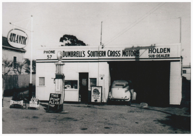
Photograph, Dumbrell's Southern Cross Motors, 52 Sussex Street, Linton
... blacksmith's workshop. In 2017 parts of the building are still ...This garage was on the site of the Ball family's blacksmith's workshop. In 2017 parts of the building are still on the site, although in a very dilapidated condition.Photograph copied from original of a petrol station/mechanic's workshop. At the time the photograph was taken the workshop was owned by John and Alice (Jill) Dumbrell. The date the photograph was taken is unknown. The car that is parked in the workshop was owned by Ernie Page, an employee of the Bank of New South Wales in Linton.john dumbrell, alice (jill) dumbrell, dumbrell's southern cross motors linton, holden dealership linton, atlantic petrol, buildings, petrol stations, mechanics, dark family -
 Sunbury Family History and Heritage Society Inc.
Photograph, c1920s - 1930s
The station in the photograph has not been identified.A black and white non-digital photograph with a cream border of people at a railway station and others looking over the post and rail fence at the people on the rail tracks. A row of trees are growing in the background and some buildings are also visible,railways -
 Linton and District Historical Society Inc
Photograph, Piggoreet Township
Piggoreet Township developed very quickly after gold was discovered in the Springdallah area (at that time called Spindella) in the 1850s. By the early 1860s the township had a population in the hundreds, as well as shops, a school, a police station and court house, hotels and churches.Copy of original photograph which shows roads, buildings, general layout of the former township at Piggoreet.piggoreet township -
 Wodonga & District Historical Society Inc
Photograph - Hut 97 Bonegilla Migrant Experience
Bonegilla Army Base and Migrant Reception Centre began when funds were allocated to build Bonegilla Army Camp in June 1940. Builders began to erect about 600 huts prior to the Army moving in during September of that year. Between 1942 - 1943 it was enlarged to 848 buildings. In 1947 Bonegilla Reception and Training Centre began operating with the Army providing transport, security and catering services. From 1949 until 1965 the Bonegilla Reception and Training Centre operated without a military presence. Bonegilla Migrant Reception and Training Centre was made up of 24 blocks. It had its own churches, banks, sporting fields, cinema, hospital, police station and railway platform. It became the largest and longest operating reception centre in the post-war era. More than 300,000 migrants passed through its doors between 1947 and 1971, with most of those originating from non-English speaking European countries. From1965 with the increased Australian commitment to the Vietnam War and the need to find accommodation to train National Servicemen for Vietnam, the Army negotiated with the Department of Immigration to take over several blocks at Bonegilla. In 1971 the Reception Centre closed and the site reverted to the Army. After 1971 the Army undertook a major site redevelopment with the construction of Latchford Barracks as the Army Apprentice School. Later Latchford Barracks was redeveloped into part of the Army Logistic Training Centre. Between 1978 and 1982, nearly all of the centre was demolished in a major redevelopment. The new replacement buildings were formally opened as Latchford Barracks in 1983. Demolition of the buildings prompted calls for recognition of the site and the role it had played in Australia’s post-World War II Immigration program. After much discussion between the Department of Army and Heritage and local groups about the significance of the site, the Australian Heritage Commission proceeded with its listing on the Register of the National Estate. A Conservation Management Plan was prepared for Block 19 in 1996. The Army transferred Block 19 to the Victorian Government. In 2002 Heritage Victoria listed Block 19 on the State Heritage Register, giving attention to both the migrant and army connections with the site. Hut 97 at Bonegilla Migrant Experience is the home of the Wodonga & District Historical Society Inc.This image is significant because it records a building which is part of the Bonegilla Migrant Reception Centre which played a critical role as the largest and longest operating Migrant Reception Centre in Australia.A colour photo of Hut 97 at Block 19, Bonegilla Migrant Experience, now the home of Wodonga & District Historical Society Inc.hut 97 bonegilla migrant experience, wodonga & district historical society, immigration australia -
 Linton and District Historical Society Inc
Photograph, Linton Railway Station and Stationmaster's House
... Black and white photograph of platform and buildings...Linton Railway Station Buildings Stationmaster's house ...Black and white photograph of platform and buildings at Linton Railway Station. The stationmaster's house can be seen on the right-hand side of the photograph.linton railway station, buildings, stationmaster's house linton -
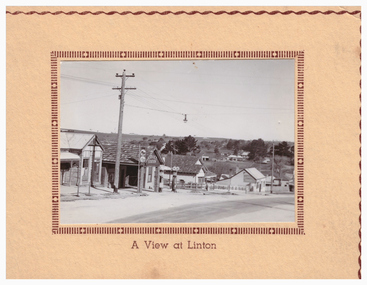 Linton and District Historical Society Inc
Postcard, A View at Linton, Sussex Street, Linton, view to south-east, circa 1940
A very small photograph which has been made into a souvenir/postcard. The photograph is a view of Sussex Street, Linton, looking to the south-east. Buildings which can be seen in the photograph include Bennett's garage/service station, the Bennett family home, and the Edinburgh Bakery. The photograph is glued to a cream-coloured card which has a decorative edge cut into it. A printed border surrounds the photograph, and the words "A View at Linton" are printed underneath it. The card appears to have had the left-hand edge trimmed with scissors.sussex street linton, buildings, shops, houses, bennett's garage, bennett family home, edinburgh bakery, postcards, souvenirs -
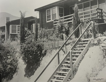 Falls Creek Historical Society
Photograph - Bogong Alpine Village Houses 1946
The images in the Bogong Village Collection were displayed in Bogong Jack’s Tavern for over 20 years and were donated to the Falls Creek Museum when the Tavern closed in 2021. In 1939, the State Electricity Commission of Victoria established a field headquarters at Bogong to house workers and their families for the Kiewa Hydroelectric Scheme which ran from the 1930s to the 1960s. The workmen's camp was originally started with tents and was called Junction Camp. By 1947, the village supported 300 workers and their families. It included 40 houses, a hostel for single staff, a post office, a police station, a medical centre, and a primary school. The staff hostel was known as Kiewa House. At the completion of the Scheme, in the 1960s, the village was opened to public/tourism use. In 1968 the Victorian Education Department acquired the camp buildings and four houses from the State Electricity Commission of Victoria to establish an Outdoor Education Centre which operated for over 50 years. The Kiewa Hydroelectric Scheme was privatized in the 1990s and sold to Southern Hydro, before being acquired by AGL in 2005. In 2023 the Grollo Group signed a 73 year sublease on Bogong Village and has plans for its redevelopment as a workers’ village.These images are significant because they capture the development of Bogong Village as an important element of the Kiewa Hydroelectric Scheme in Victoria.Two black and white images featuring houses in Bogong Village in January 1946. They are constructed of weatherboard, with brick chimneys and tin roofs. Timber steps lead up to the front door and a garden has been planted in front of the house.bogong alpine village, bogong high plains, bogong houses 1946 -
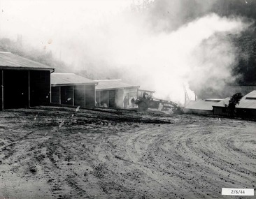 Falls Creek Historical Society
Photograph - Bogong Alpine Village 1944
The images in the Bogong Village Collection were displayed in Bogong Jack’s Tavern for over 20 years and were donated to the Falls Creek Museum when the Tavern closed in 2021. In 1939, the State Electricity Commission of Victoria established a field headquarters at Bogong to house workers and their families for the Kiewa Hydroelectric Scheme which ran from the 1930s to the 1960s. The workmen's camp was originally started with tents and was called Junction Camp. By 1947, the village supported 300 workers and their families. It included 40 houses, a hostel for single staff, a post office, a police station, a medical centre, and a primary school. The staff hostel was known as Kiewa House. At the completion of the Scheme, in the 1960s, the village was opened to public/tourism use. In 1968 the Victorian Education Department acquired the camp buildings and four houses from the State Electricity Commission of Victoria to establish an Outdoor Education Centre which operated for over 50 years. The Kiewa Hydroelectric Scheme was privatized in the 1990s and sold to Southern Hydro, before being acquired by AGL in 2005. In 2023 the Grollo Group signed a 73 year sublease on Bogong Village and has plans for its redevelopment as a workers’ village.These images are significant because they capture the development of Bogong Village as an important element of the Kiewa Hydroelectric Scheme in Victoria.A collection of four black and white images capturing the weather conditions in the Bogong area in June 1944bogong alpine village, bogong high plains, bogong june 1944 -
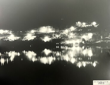 Falls Creek Historical Society
Photograph - Bogong Alpine Village 1947
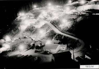
The images in the Bogong Village Collection were displayed in Bogong Jack’s Tavern for over 20 years and were donated to the Falls Creek Museum when the Tavern closed in 2021. In 1939, the State Electricity Commission of Victoria established a field headquarters at Bogong to house workers and their families for the Kiewa Hydroelectric Scheme which ran from the 1930s to the 1960s. The workmen's camp was originally started with tents and was called Junction Camp. By 1947, the village supported 300 workers and their families. It included 40 houses, a hostel for single staff, a post office, a police station, a medical centre, and a primary school. The staff hostel was known as Kiewa House. At the completion of the Scheme, in the 1960s, the village was opened to public/tourism use. In 1968 the Victorian Education Department acquired the camp buildings and four houses from the State Electricity Commission of Victoria to establish an Outdoor Education Centre which operated for over 50 years. The Kiewa Hydroelectric Scheme was privatized in the 1990s and sold to Southern Hydro, before being acquired by AGL in 2005. In 2023 the Grollo Group signed a 73 year sublease on Bogong Village and has plans for its redevelopment as a workers’ village.These images are significant because they capture the development of Bogong Village as an important element of the Kiewa Hydroelectric Scheme in Victoria.Two black and white images capturing Bogong Village by night and the spillway at Junction Dam.bogong alpine village, bogong high plains, bogong 1947 -
 Linton and District Historical Society Inc
Photograph, View to south west along Sussex Street, Linton, 2014
... Ruby Cocoa café Linton police station Buildings Jennnings ...Colour photograph showing trees and buildings in Sussex Street, Linton: 'Ruby Cocoa' café, police station, former Jenning's milk bar.ruby cocoa café, linton police station, buildings, jennnings milk bar -
 Falls Creek Historical Society
Photograph - Jack Maddison Leading horses on the Bogong High Plain
The images in the Bogong Village Collection were displayed in Bogong Jack’s Tavern for over 20 years and were donated to the Falls Creek Museum when the Tavern closed in 2021. In 1939, the State Electricity Commission of Victoria established a field headquarters at Bogong to house workers and their families for the Kiewa Hydroelectric Scheme which ran from the 1930s to the 1960s. The workmen's camp was originally started with tents and was called Junction Camp. By 1947, the village supported 300 workers and their families. It included 40 houses, a hostel for single staff, a post office, a police station, a medical centre, and a primary school. The staff hostel was known as Kiewa House. At the completion of the Scheme, in the 1960s, the village was opened to public/tourism use. In 1968 the Victorian Education Department acquired the camp buildings and four houses from the State Electricity Commission of Victoria to establish an Outdoor Education Centre which operated for over 50 years. The Kiewa Hydroelectric Scheme was privatized in the 1990s and sold to Southern Hydro, before being acquired by AGL in 2005. In 2023 the Grollo Group signed a 73 year sublease on Bogong Village and has plans for its redevelopment as a workers’ village. John Maddison and his wife Mary Padman emigrated from London to Australia in 1850 with their five sons. Jack (John James William Maddison) was one of their great grandsons. In 1877 Jack’s grandfather George Maddison selected land between the East and West Kiewa branches of the Kiewa River - known as the "Island". It is now known as Mount Beauty. The Maddison family built Aertex Hut at the top of T Spur at Mt. Bogong for use when grazing cattle. It later became known as Maddison's Hut. Staircase Spur walking track at Bogong was formerly known as Maddison’s Track as it is the path once used by the Maddison family to drive their cattle on to the high plains. These images are significant because they feature the son of a pioneering family on the Bogong High Plains.A black and white photograph of Jack Maddison leading horses on the Bogong High Plains.bogong alpine village, bogong high plains, maddison family mt beauty, maddison's hut, aertex hut, -
 Falls Creek Historical Society
Photograph - Bogong Alpine Village and Howman's Dam Camp 1948
The images in the Bogong Village Collection were displayed in Bogong Jack’s Tavern for over 20 years and were donated to the Falls Creek Museum when the Tavern closed in 2021. In 1939, the State Electricity Commission of Victoria established a field headquarters at Bogong to house workers and their families for the Kiewa Hydroelectric Scheme which ran from the 1930s to the 1960s. The workmen's camp was originally started with tents and was called Junction Camp. By 1947, the village supported 300 workers and their families. It included 40 houses, a hostel for single staff, a post office, a police station, a medical centre, and a primary school. The staff hostel was known as Kiewa House. At the completion of the Scheme, in the 1960s, the village was opened to public/tourism use. In 1968 the Victorian Education Department acquired the camp buildings and four houses from the State Electricity Commission of Victoria to establish an Outdoor Education Centre which operated for over 50 years. The Kiewa Hydroelectric Scheme was privatized in the 1990s and sold to Southern Hydro, before being acquired by AGL in 2005. In 2023 the Grollo Group signed a 73 year sublease on Bogong Village and has plans for its redevelopment as a workers’ village.These images are significant because they capture the development of Bogong Village as an important element of the Kiewa Hydroelectric Scheme in Victoria.Two images capturing the depiction Bogong Village and the Howman's Dam Camp 1948bogong alpine village, bogong high plains, bogong 1947 -
 Falls Creek Historical Society
Photograph - Aerial View of Bogong Alpine Village
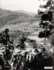
The images in the Bogong Village Collection were displayed in Bogong Jack’s Tavern for over 20 years and were donated to the Falls Creek Museum when the Tavern closed in 2021. In 1939, the State Electricity Commission of Victoria established a field headquarters at Bogong to house workers and their families for the Kiewa Hydroelectric Scheme which ran from the 1930s to the 1960s. The workmen's camp was originally started with tents and was called Junction Camp. By 1947, the village supported 300 workers and their families. It included 40 houses, a hostel for single staff, a post office, a police station, a medical centre, and a primary school. The staff hostel was known as Kiewa House. At the completion of the Scheme, in the 1960s, the village was opened to public/tourism use. In 1968 the Victorian Education Department acquired the camp buildings and four houses from the State Electricity Commission of Victoria to establish an Outdoor Education Centre which operated for over 50 years. The Kiewa Hydroelectric Scheme was privatized in the 1990s and sold to Southern Hydro, before being acquired by AGL in 2005. In 2023 the Grollo Group signed a 73 year sublease on Bogong Village and has plans for its redevelopment as a workers’ village.These images are significant because they capture the development of Bogong Village as an important element of the Kiewa Hydroelectric Scheme in Victoria.An aerial view of Bogong Village and surrounds, date unknown.bogong alpine village, bogong high plains, aerial photos bogong village -
 Falls Creek Historical Society
Photograph - Bogong Alpine Village 1940
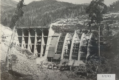
The images in the Bogong Village Collection were displayed in Bogong Jack’s Tavern for over 20 years and were donated to the Falls Creek Museum by the Liz Krien & the Bogong Village Trust Board when the Tavern closed in 2021. In 1939, the State Electricity Commission of Victoria established a field headquarters at Bogong to house workers and their families for the Kiewa Hydroelectric Scheme which ran from the 1930s to the 1960s. The workmen's camp was originally started with tents and was called Junction Camp. By 1947, the village supported 300 workers and their families. It included 40 houses, a hostel for single staff, a post office, a police station, a medical centre, and a primary school. The staff hostel was known as Kiewa House. At the completion of the Scheme, in the 1960s, the village was opened to public/tourism use. In 1968 the Victorian Education Department acquired the camp buildings and four houses from the State Electricity Commission of Victoria to establish an Outdoor Education Centre which operated for over 50 years. The Kiewa Hydroelectric Scheme was privatized in the 1990s and sold to Southern Hydro, before being acquired by AGL in 2005. In 2023 the Grollo Group signed a 73 year sublease on Bogong Village and has plans for its redevelopment as a workers’ village.These images are significant because they capture the development of Bogong Village as an important element of the Kiewa Hydroelectric Scheme in Victoria.A collection of 10 black and white images capturing the development of Bogong Alpine Village. They depict development of the new village, the surrounding area and some staff members during 1940.bogong alpine village, bogong 1940, bogong high plains -
 Falls Creek Historical Society
Photograph - Bogong Alpine Village 1943
The images in the Bogong Village Collection were displayed in Bogong Jack’s Tavern for over 20 years and were donated to the Falls Creek Museum when the Tavern closed in 2021. In 1939, the State Electricity Commission of Victoria established a field headquarters at Bogong to house workers and their families for the Kiewa Hydroelectric Scheme which ran from the 1930s to the 1960s. The workmen's camp was originally started with tents and was called Junction Camp. By 1947, the village supported 300 workers and their families. It included 40 houses, a hostel for single staff, a post office, a police station, a medical centre, and a primary school. The staff hostel was known as Kiewa House. At the completion of the Scheme, in the 1960s, the village was opened to public/tourism use. In 1968 the Victorian Education Department acquired the camp buildings and four houses from the State Electricity Commission of Victoria to establish an Outdoor Education Centre which operated for over 50 years. The Kiewa Hydroelectric Scheme was privatized in the 1990s and sold to Southern Hydro, before being acquired by AGL in 2005. In 2023 the Grollo Group signed a 73 year sublease on Bogong Village and has plans for its redevelopment as a workers’ village.These images are significant because they capture the development of Bogong Village as an important element of the Kiewa Hydroelectric Scheme in Victoria.A collection of seven black and white images capturing the development of Bogong Alpine Village and the Pretty Valley area during 1943.bogong alpine village, bogong high plains, bogong 1943 -
 Falls Creek Historical Society
Photograph - Bogong Alpine Village 1942
The images in the Bogong Village Collection were displayed in Bogong Jack’s Tavern for over 20 years and were donated to the Falls Creek Museum when the Tavern closed in 2021. In 1939, the State Electricity Commission of Victoria established a field headquarters at Bogong to house workers and their families for the Kiewa Hydroelectric Scheme which ran from the 1930s to the 1960s. The workmen's camp was originally started with tents and was called Junction Camp. By 1947, the village supported 300 workers and their families. It included 40 houses, a hostel for single staff, a post office, a police station, a medical centre, and a primary school. The staff hostel was known as Kiewa House. At the completion of the Scheme, in the 1960s, the village was opened to public/tourism use. In 1968 the Victorian Education Department acquired the camp buildings and four houses from the State Electricity Commission of Victoria to establish an Outdoor Education Centre which operated for over 50 years. The Kiewa Hydroelectric Scheme was privatized in the 1990s and sold to Southern Hydro, before being acquired by AGL in 2005. In 2023 the Grollo Group signed a 73 year sublease on Bogong Village and has plans for its redevelopment as a workers’ village.These images are significant because they capture the development of Bogong Village as an important element of the Kiewa Hydroelectric Scheme in Victoria.A collection of four black and white images capturing the development of Bogong Alpine Village and the Pretty Valley area during 1942.bogong alpine village, bogong high plains, bogong 1942 -
 Falls Creek Historical Society
Photograph - Bogong Alpine Village 1941
The images in the Bogong Village Collection were displayed in Bogong Jack’s Tavern for over 20 years and were donated to the Falls Creek Museum when the Tavern closed in 2021. In 1939, the State Electricity Commission of Victoria established a field headquarters at Bogong to house workers and their families for the Kiewa Hydroelectric Scheme which ran from the 1930s to the 1960s. The workmen's camp was originally started with tents and was called Junction Camp. By 1947, the village supported 300 workers and their families. It included 40 houses, a hostel for single staff, a post office, a police station, a medical centre, and a primary school. The staff hostel was known as Kiewa House. At the completion of the Scheme, in the 1960s, the village was opened to public/tourism use. In 1968 the Victorian Education Department acquired the camp buildings and four houses from the State Electricity Commission of Victoria to establish an Outdoor Education Centre which operated for over 50 years. The Kiewa Hydroelectric Scheme was privatized in the 1990s and sold to Southern Hydro, before being acquired by AGL in 2005. In 2023 the Grollo Group signed a 73 year sublease on Bogong Village and has plans for its redevelopment as a workers’ village.These images are significant because they capture the development of Bogong Village as an important element of the Kiewa Hydroelectric Scheme in Victoria.A collection of four black and white images capturing the development of Bogong Alpine Village. They depict development of the new village, the surrounding area and some staff members during 1941.bogong alpine village, bogong high plains, bogong 1941 -
 Sunbury Family History and Heritage Society Inc.
Photograph, The Royal Hotel, 1936
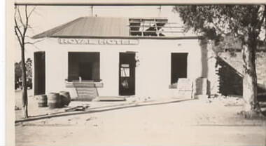
The single storey Royal Hotel was built on the SE corner of Brook and Evans Street in 1861, two years after a rail service reached Sunbury. It occupied that site until July 1936 after a fire destroyed the building. It was decided to demolish the old hotel and replace it with a modern building. The first stages of the building's demolition have been captured in this image.The Royal Hotel was one of the first hotels to be built in Evans Street when businesses moved from Macedon Street closer to the station after rail services came to Sunbury in 1859.A non-digital black and white photograph of a single storey hotel building being demolished. The doors and windows have been removed as well a portion of the iron roofing. Three empty barrels are stacked by the doorway. royal hotel, brook street, evans street, hotels -
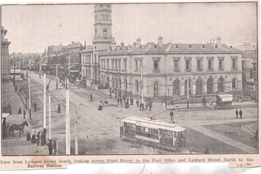 Ballarat Tramway Museum
Photograph - Illustration, WTP, "View from Lydiard Street South looking across Sturt St", c1907
Illustration of the intersection of Sturt St and Lydiard St Nth with the Ballarat Post Office being the primary feature. Has an ESCo tram turning from Sturt St into Lydiard St. Shows the trackwork at this location and has several horse-drawn vehicles in the photograph. Note the building in the road space on the left-hand side of the photograph. The caption along the bottom edge "View from Lydiard Street South looking across Sturt Street to the Post Office and Lydiard Street North to the Railway Station. On the rear has an item about Ballarat itself and its history. See also item 6245 for a postcard of this view. Yields information about the post office corner at the time of the opening of the tramway and demonstrates printing techniques.Black and white Illustration cut from a journaltramways, trams, sturt st, esco, post office, lydiard st north