Showing 810 items matching " aerial views"
-
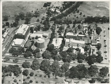 International House, The University of Melbourne
Photograph (Item), Aerial view of the site of International House (includes Scheps Building)
... Aerial view of the site of International House (includes...Black and white photograph of Aerial view of the site... Building) Aerial view of the site of International House (includes ... -
 Bendigo Historical Society Inc.
Map - BENDIGO MAP AERIAL VIEW, 1934
... BENDIGO MAP AERIAL VIEW...Map of Bendigo. Aerial View of Bendigo taken in 1934... PHOTOGRAPH Aerial bendigo 1934 Map of Bendigo. Aerial View of Bendigo ...Map of Bendigo. Aerial View of Bendigo taken in 1934. Published by City of Great Bendigo.photograph, aerial, bendigo 1934 -
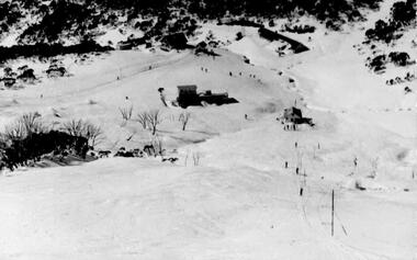 Falls Creek Historical Society
Postcard - Views of Falls Creek 1959
... A set of postcards showing aerial views of Falls Creek... aerial views of Falls Creek as well as groups of skiers ...postcards feature images taken by Frederick Charles Griffith. “Fred” Griffith was born in Albury, NSW on 2 March 1910. Educated in Albury and Geelong Grammar. Beginning in 1927 he spent many years working first as a jackeroo and on a range of prominent pastoral and merino stud properties in NSW and Queensland. In 1935 he repurchased his former family property “Toonallook", Bowna, NSW and developed it to be the largest Romney Marsh stud in the world, exporting rams to Argentina. He introduced many innovative practices on his property including rabbit control measures and aerial crop dusting. He was an active member of the Albury Show Society and in 1949 established the Albury Sheep Show. Fred was also the Albury representative on the Graziers’ Association Council for over 30 years. He became a life member of both the Albury and Commercial Clubs. Fred’s greatest hobby was snow skiing. His first visit to the snow was to Kosciusko in 1919. The Albury Ski Club was formed in 1935 and Fred was an inaugural member. In 1949 they were granted a site at Falls Creek to build their own lodge. Fred guaranteed the Club for finance from the Bank of NSW. The first portion of the prefabricated building was constructed in Albury. It was transported to Falls Creek on the back of Fred’s truck and erected in one day. This was the bathroom section and the rest was completed in 1950. The original lodge was burned down in 1952 and a new one built the following year. In 1955, Fred also built the Bowna Lodge for his family in partnership with David Fairbairn. He became head of the North Eastern District Skiing Association (N.E.D.S.A.) and successfully applied to run the Australian Ski Championships. Fred also inaugurated children’s races at Falls Creek and ran them for about 20 years. He also formed the company “Falls Creek Ski Tows”. In 1956 Fred along with a group of key people selected the site for Thredbo Village. Fred and his brother sold Toonallook in sections between 1951 and 1974. He moved to Albury and set up as a landscape gardener and fencing contractor. After a serious work accident, Fred retired in 1985 and moved to Rosebud, Victoria where he died on 19 August 1992.These postcards document how Falls Creek was portrayed to the wider community.A set of postcards showing aerial views of Falls Creek as well as groups of skiers on the slopes, On Back of each card: POSTCARD CORRESPONDENCE / ADDRESS ONLY In a square for stamp Placement - KODAKfred griffith, albury ski club, falls creek, bowna ski club -
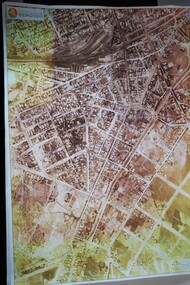
 Bendigo Military Museum
Map - MAP HUE VIETNAM, C.1960’s
... Colour printed map of Hue Citadel on paper. Aerial view... on paper. Aerial view of land, river and building outlines. Map MAP ...The city of Hue is in South Vietnam. The map was used by a member of the AATTV during the Tet Offensive in Thau Thien province. Map brought home from Vietnam by Murray Stanley Metherall. Refer 590.2.Colour printed map of Hue Citadel on paper. Aerial view of land, river and building outlines.hue, vietnam, tet -
 Robin Boyd Foundation
Slide, Robin Boyd, 1966
... Colour slide in a mount. Aerial view, probably of Northern... / Encircled 1 (Handwritten) Colour slide in a mount. Aerial view ...Robin Boyd was appointed Exhibits Architect for the Australian Pavilion at Expo ‘67 in Montreal. In 1966 Boyd travelled to Far North Queensland and the Northern Territory for research – the Expo exhibits included a coral display, a large rock feature made from Australian sandstone and a native plant garden.Colour slide in a mount. Aerial view, probably of Northern Territory, when visiting Alice SpringsMade in Australia / 31 / DEC 66M4 / Encircled 1 (Handwritten)northern territory, slide -
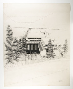 RMIT Design Archives
Architectural drawings
... Architectural perspective drawing featuring aerial view... perspective drawing featuring aerial view of the Chancery ...Architectural perspective drawing featuring aerial view of the Chancery at the Australian High Commission, Kuala Lumpurink, acetate -
 Federation University Art Collection
Bookplate, 'Ex Libris Kevin'
... An aerial view depicts a red-roofed house and a tractor... An aerial view depicts a red-roofed house and a tractor amongst ...After a quiet period, interest in bookplates in Australia began to increase in the early 1970s, Entrepreneurial art and book collectors such as Edwin Jewell and others commissioned multiple Bookplate designs from a range of well known fine artists. At a 1997 meeting in Melbourne of the Ephemera Society of Australia Edwin Jewell and others announced the formation of the Australian Bookplate Society. The society was instrumental in promoting the art of the bookplate through establishment of the Australian Bookplate Design competition.An aerial view depicts a red-roofed house and a tractor amongst green, yellow and brown paddocks.Kevin Marriot on backbookplate, printmaking, australian bookplate design award -
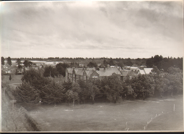 Ballarat and Queen's Anglican Grammar School
b&w Photograph, Aerial view of Ballarat Grammar buildings
... Aerial view of Ballarat Grammar buildings...aerial view of school buildings with large trees along... St. N. 2996 pencilled on verso aerial view of school ...aerial view of school buildings with large trees along building line and hedge around propertyVerso - N. L. HARVEY (Press Photo Service) A.M.P. Chambers Lydiard St. N. 2996 pencilled on versoballarat-grammar, education, ballarat, wendouree, school -
 Lakes Entrance Historical Society
Photograph - Lakes Entrance, Brian Lloyd, c1954
... Aerial view of Lakes Entrance c1954. Plus 2 other aerial...Aerial view of Lakes Entrance c1954. Plus 2 other aerial ...Aerial view of Lakes Entrance c1954. Plus 2 other aerial views in albumBlack and white photograph of a section of the town taking in St Brendans church, Bulmer Street from Esplanade to Church Street, some of the waterfront, the footbridge and hummocks Lakes Entrance Victoriaaerial photograph, township, beaches -
Glenelg Shire Council Cultural Collection
Photograph - Photograph - Tohoku Paper Co., Ltd., Akita Mill, n.d
... Aerial view of a factory on the coast. Jetties and piers...: Tohoku Paper Co., Ltd, Akita Mill Aerial view of a factory ...Glenelg Shire Council RecordsAerial view of a factory on the coast. Jetties and piers in background. Framed in aluminium frame with thin plastic glazing.Front: Tohoku Paper Co., Ltd, Akita Millpaper and pulp industries, japan, maritime industry -
 Federation University Historical Collection
photographs and negatives, Aerial Photographs of Ballarat and Mount Helen, c1985
... of aerial views of Ballarat, Mt Helen and Mount Buninyong... photographs and 47 negative strips of aerial views of Ballarat, Mt ...Thirteen colour photographs and 47 negative strips of aerial views of Ballarat, Mt Helen and Mount Buninyongballarat, mount helen, buninyong, aerial photographs, student residences, bella guering residence, peter lalor residences, mount helen campus, camp street campus, arts academy, lake wendouree, ballarat cbd, ballarat school of mines, smb campus -
Glenelg Shire Council Cultural Collection
Photograph - Photograph - Aerial view of Thomas Borthwick and Sons abattoir, c. 1968
... Photograph - Aerial view of Thomas Borthwick and Sons...Black and white photograph. Aerial view of Thomas Borthwick... UP TO 1000 PERSONNEL Black and white photograph. Aerial view ...Port of Portland Authority archives.Front: (no inscriptions) Back: T.B + S PORTLAND ABBATOIR/ PORTLAND'S MAJOR INDUSTRY EMPLOYS UP TO 1000 PERSONNELport of portland archives, thomas borthwick and sons abattoir, drive-in theatre -
Stawell Historical Society Inc
Book - Report, Grampians National Park Draft Management Plan, 1985
... Soft Cover with B/W Photo of aerial view of ranges... Barry Clugston Soft Cover with B/W Photo of aerial view ...For Public comment to National Park Service, Victoria. A Division of the department of Conservation, Forest and LandsSoft Cover with B/W Photo of aerial view of ranges of Grampians. Black taped Spine binding.$5 Barry Clugston -
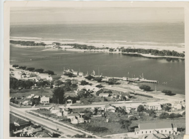
 Port Fairy Historical Society Museum and Archives
Photograph
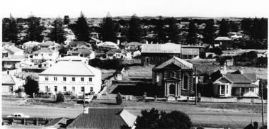
... Black and white photograph of aerial view Caledonian... victoria hotel Black and white photograph of aerial view Caledonian ...SE view from St Johns Tower 1973Black and white photograph of aerial view Caledonian & Victoria Hotels centre. Reardon theatre far leftst john's tower, tower, st johns, town, aerial, caledonian, victoria, hotel -
 University of Melbourne, Burnley Campus Archives
Photograph - Black and white prints, Aerial View of Burnley Campus, 1963-1970
... Aerial View of Burnley Campus...aerial view...Black and white photographs. Aerial View of Burnley Campus.... burnley campus aerial view south eastern freeway richmond park ...Freeway was not begun until 1968.Black and white photographs. Aerial View of Burnley Campus. (B) Original of (A). Enlargement (C) Laminated copy(A) Inscribed on reverse, "South Eastern Freeway 9.7.63 R22.024.439." (C) Paper attachment: The Burnley College Portion of Richmond Park in 1972. Swan Street Takes Its Familiar Route. The Boulevard Has Been Constructed. The Golf Course is in Place. The Series of Parallel Buildings Along the Railway Line at the Bottom of the Photo Are the Poultry Sheds Used For Egg-Laying Competitions. Burnley Sidings Were Still to be Built. In the Mid-1990's Much of the Western Portion of the College Grounds/Richmond Park Was Sold.burnley campus, aerial view, south eastern freeway, richmond park, swan street, yarra boulevard, richmond golf course, poultry sheds -
 University of Melbourne, Burnley Campus Archives
Photograph - Black and white print, Airspy, Aerial View of Burnley Campus c. 1925, c. 1925
... Aerial View of Burnley Campus c. 1925...Colour photograph of black and white photograph. Aerial... photograph of black and white photograph. Aerial view of Burnley ...TH Kneen and EB Littlejohn note that the Principal's House has been extended. This was done for J P McLennan, Principal 1917-1921. Note "Bird Cage" in Orchard, dwarf fruit trees, shed where tobacco was stored. Photo taken before Plant Research Institute was built in 1929. Photo shows there had been cultivation outside the College grounds, beyond the orchard area and hedge.Colour photograph of black and white photograph. Aerial view of Burnley Campus. Cultivation outside Burnley Campus burnley campus, principal's house, jp mclennan, bird cage, orchard, dwarf fruit trees, plant research institute, principal's residence, tobacco storage sheds, cultivation outside campus -
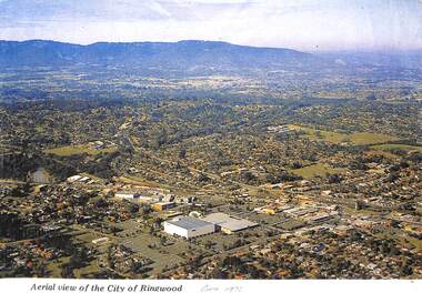 Ringwood and District Historical Society
Photograph, Aerial view of the City of Ringwood - Circa 1972
... Aerial view of the City of Ringwood - Circa 1972..."Written on face of photograph" Aerial view of the City..." Aerial view of the City of Ringwood showing Eastland (stage 1 ...Coloured photograph"Written on face of photograph" Aerial view of the City of Ringwood showing Eastland (stage 1), Ringwood High and Technical Schools. -
Glenelg Shire Council Cultural Collection
Photograph, Softwoods Holdings Site, North Portland, April 1976, 1976
... Aerial view of a large open field with large building..., centre) Aerial view of a large open field with large building ...Port of Portland Authority archives.Back: Softwoods Holdings Site North Portland (lower left, pencil) APRIL, 1976 (lower left, blue pen) Portland Harbor Trust Commissioners (purple stamp, centre)port of portland -
 Eltham District Historical Society Inc
Photograph, Yarra River, Sweeneys flats, 1994c
... Colour photogrpah of oblique aerial view looking east over... photographs Colour photogrpah of oblique aerial view looking east over ...Colour photogrpah of oblique aerial view looking east over Yarra River and Sweeneys flats c.1994sweeneys lane, yarra river, culla hill, thomas sweeney, aerial photographs -
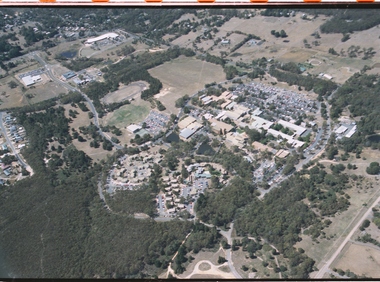
 Federation University Historical Collection
Photograph - Photograph - Colour, Federation University Gippsland Campus, c1995, c1995
... Large photograph adhered to foamcore showing an aerial view... showing an aerial view of the Federation University Gippsland ...The following information was the preface of the 1985 GIAE handbook: The Gippsland institute of Advanced Education was established by an Order-in-Council in September, 1968, but, owes its origin to engineering diploma courses established in 1928 to service the developing electrical industry. The Council of the Institute includes members of the Gippsland community who are prominent in industry, commerce, education and the professions, the Director of the institute, the representative of the academic staff, of general staff, of students and of the Convocation of the Institute. In 1972 the Institute occupied the first of its permanent buildings on a large campus in rural surroundings near the township of Churchill, ten kilometres south of Morwell and one hundred and sixty kilometres east of Melbourne. Engineering laboratories are temporarily located in buildings on the site of the Yallourn College of TAFE at Newborough and they will be consolidated on the Churchill campus by the end on 1985. In 1974 new buildings were completed under a self-help program to house the School of Visual Arts. A building complex to provide the first stages of the permanent library and the Union, and accommodation for the School of Business and Social Sciences was completed in 1976. An Education building, an Applied Science building and student residential buildings for 108 student places were completed at the beginning on 1976. The Binishell, a multi-purpose facility was completed in 1980. On its establishment, the Institute assumed responsibility for the diploma courses which were previously offered by the Yallourn Technical College. These were diploma in Civil, Electrical, and Mechanical Engineering, Applied Chemistry, and Business, all of which were recognised by the appropriate professional bodies. The Gippsland Institute of Advanced Education is the only centre of Higher Education east of Melbourne and offers a range of vocational courses at associate diploma, diploma, degree, graduate degree and master levels to meet the educational needs of the Gippsland regions. The institute also has a very large commitment to a program on external studies. Federation University Australia was established on 1 January 2014. Formerly known as the University of Ballarat, its enabling legislation was the University of Ballarat Amendment (Federation University Australia) Act 2013. Although formally created as a University in 1994, the University of Ballarat had a lineage back to 1870 with the establishment of the School of Mines Ballarat, making it the third institution of higher learning to be established in Australia and the first to be established in regional Australia. On 1 January 1994, Ballarat University College became the University of Ballarat and in 1998 the University merged with three TAFE Institutes to become a dual sector institution with multiple campuses. On 1 January 2014, the University of Ballarat amalgamated with the Monash University Gippsland Campus to form Federation University Australia. The Gippsland Campus also had a long lineage dating back to 1928 with the establishment of the Yallourn Technical School which became a predecessor institution to the Gippsland College of Advanced Education formed in 1968. In 1990, it was renamed the Monash University College and in 1993 became the Gippsland Campus of Monash University. Large photograph adhered to foamcore showing an aerial view of the Federation University Gippsland Campus at Churchill, Victoria as it was c1995.churchill, gippsland campus, gippsland institute of advanced education, federation university, yallourn, morwell, binishell -
Glenelg Shire Council Cultural Collection
Photograph - Photograph - Aerial view of Thomas Borthwick and Sons abattoir and Walock Swamp, Nov-55
... Photograph - Aerial view of Thomas Borthwick and Sons...Black and white photograph. Aerial view of taken from... Victoria Australia Black and white photograph. Aerial view of taken ...Port of Portland Authority archives.Front: (no inscriptions) Back: 'AIRSPY PHOTO' CD PRATT 86 McCracken St ref No2/B/73 Essendon Phone Fx 2840 Victoria Australiaport of portland archives, tb and s abattoir, walock swamp -
Glenelg Shire Council Cultural Collection
Photograph - Photograph - View of port and facilities, c. 1974
... Black and white photograph. Aerial view taken from...: (no inscriptions) Black and white photograph. Aerial view taken from ...Port of Portland Authority archives.Front: (no inscriptions) Back: (no inscriptions)port of portland archives, portland harbour, k s anderson, no6, no5 berths -
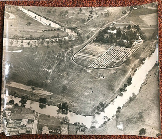
 Bendigo Historical Society Inc.
Photograph - Aerial View Sydenham Gardens Estate Circa 1972
... Aerial View Sydenham Gardens Estate Circa 1972...Photograph: aerial view of Sydenham Gardens Estate Circa... Photograph: aerial view of Sydenham Gardens Estate Circa 1972 ...The Sydenham gardens were set up in 1854 to provide an area of relaxation for diggers. A German, Mr Kraemer, made extensive plantings of ornamentals and fruit trees. The area expanded to 11 acres in 1865 and 25 acres in 1916. T O Hunter owned the gardens from about 1896 and initially it was used for many types of entertainment including, picnics, festivals and sporting events. It was situated off Holdsworth Road in what is now Jackass Flat. T O Hunter was a cordial manufacturer in Macrae Street, who was prominent in many sporting areas. He was President of the Bendigo Coursing Association and raced both dogs and horses. By the time he sold the gardens in 1936 to Mr Muir, he was using the gardens as grazing for his horses.Photograph: aerial view of Sydenham Gardens Estate Circa 1972 , as noted on photo Colour photo, A5 sizephoto sydenham gardens estate, aerial photo -
 Bendigo Historical Society Inc.
Photograph - HANRO COLLECTION: AERIAL VIEW OF HANRO BENDIGO
... HANRO COLLECTION: AERIAL VIEW OF HANRO BENDIGO...Photograph. Black and White aerial view photograph... and White aerial view photograph of the Hanro Knitting Mills ...Photograph. Black and White aerial view photograph of the Hanro Knitting Mills, Hargreaves Street, Bendigo, in the centre of the photo.organization, business, hanro knitting mills, hanro -
Stawell Historical Society Inc
Archive - Handbook, Aunde Employee Induction Handbook, 18/12/2003
... aerial view Aunde Buildings... Plastic Cover over book. Black Card cover. B/W. Photo aerial view ...Plastic Cover over book. Black Card cover. B/W. Photo aerial view Aunde BuildingsAunde Australia Oty Ltd. Employee Induction Handbook -
 Port Fairy Historical Society Museum and Archives
Photograph
... Black and white photograph aerial view of Braim House... house Black and white photograph aerial view of Braim House ...Views from St Johns 1973Black and white photograph aerial view of Braim House Methodist Church and it's Manse with Sunday school in backgroundphoto, st johns, tower, james street, aerial, methodist, weslyian, braim house -
 City of Kingston
Photograph - Black and white, c. 1944
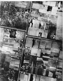
... Black and white aerial view of Moorabbin. Houses, market... Parkdale Aerial photograph of Moorabbin, including Chesterville ...Aerial photograph of Moorabbin, including Chesterville Road, Keys Road and Wickham Road, Moorabbin, Briggs cottage, Neill's waterhole, McKittrick property, site of FRUMELBlack and white aerial view of Moorabbin. Houses, market garens, roads, and water features are all clearly visible.Handwritten in red ink on reverseL A 603 / 97% [in red circle] Handwritten in blue ink on reverse: 9502 06111 / M'bbinmoorabbin, city of moorabbin, chesterville, keys, wickham -
 Ballarat and Queen's Anglican Grammar School
b&w Photograph, Aerial photograph of School Buildings
... Aerial view of School buildings showing chapel LHS.... Chambers Lydiard St. N. 2993 pencilled in on verso Aerial view ...Aerial view of School buildings showing chapel LHS and foreground on south east corner of Ballarat Grammar propertyVerso - N. L. HARVEY (Press Photo Service) A.M.P. Chambers Lydiard St. N. 2993 pencilled in on versoballarat-grammar, buildings, school, education, wendouree, ballarat, chapel -
 Federation University Historical Collection
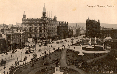
Postcard - Black and white, Valentine, Donegall Square, Belfast
... Black and white postcard showing an aerial view of Donegall... and white postcard showing an aerial view of Donegall Square ...WW1 Holmes Family souvenirAustralian soldier's WW1 souvenirBlack and white postcard showing an aerial view of Donegall Square in Belfast. Trams, horses and people are evident on the streetschatham-holmes family collection, belfast, ireland -
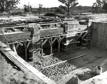 Federation University Historical Collection
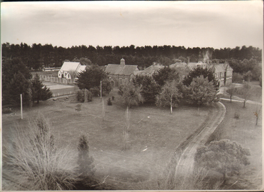
Photograph, N.l. Harvey & Son, Mount Helen Campus, 1968, 1969
... development. .1) Aerial view of foundation work, from west, towards...) Aerial View from South. Earthworks and foundations .3) Aerial ...The Federation University campus at Mount Helen was first used by students in 1970.Seven photographs of the Mt Helen Campus Stage one development. .1) Aerial view of foundation work, from west, towards Green Hill .2) Aerial View from South. Earthworks and foundations .3) Aerial View from south west. Earthworks, general view .4) Aerial View from above the South West corner of E building. .5) Aerial View from North East. Gear Avenue in background .6) Aerial View from North West. Earthworks extend from Gear Avenue .7) Ground level view. First columns of E building. .13) Mt Helen development Stage One, Engineering Diploma Buildings. This image shows the wall beam and pier construction to the East Wall of the Fluid Mechanics Laboratory adjacent to the pump chamber, 17 June 1968. .18) Flume Pit and Pump Chamber, 15 July 1968. .28) East Wing Pit Looking North, 26 August 1968 .40) Construction as of 04 November 1968federation university, federation university australia, feduni, university of ballarat, ballarat college of advanced education, ballarat institute of advanced education, building, earthworks, foundation, early development, soil testing laboratory