Showing 347 items
matching footbridges
-
 Eltham District Historical Society Inc
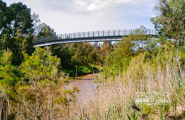
Photograph, Footbridge across the Yarra River at Eltham Lower Park
The Yarra River Footbridge was opened in August 2004 and links the Diamond Creek Trail between the Shire of Nillumbik and City of Manningham. It is a shared pathway and also links with the Main Yarra Trail. It affords lovely views over the Yarra River.Colour photographbridge, eltham lower park, eltham south, homestead road, lenister farm, yarra river, footbridge, lookout, diamond creek trail -
 Lakes Entrance Historical Society
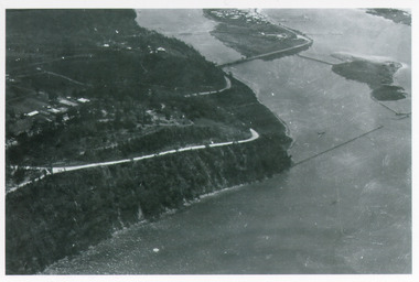
Photograph - Kalimna, Bulmer H D, 1940c
Black and white photograph of aerial view of Kalimna Heights, showing scattered buildings, Princes Highway around side of cliff, western end of township, North Arm bridge, footbridge to Bullock Island, and rock groynes. Track to lookout and signal beacon visible. Lakes Entrance Victoria waterways, roads and streets, bridges, township -
 Lakes Entrance Historical Society
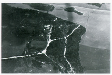
Photograph - Kalimna, Bulmer H D, 1940c
Black and white photograph of aerial view of Kalimna escarpment, Princes Highway, road to Kalimna Hotel, scattering of buildings including Gainsborough House, in distance is North Arm bridge, footbridge to undeveloped Bullock Island with rock groynes in place. Part of eastern pier of entrance at Lakes Entrance, Victoria. waterways, topography, township, bridges -
 Ringwood and District Historical Society
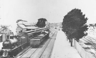
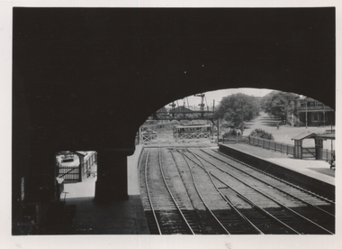
Photograph, Ringwood railway station looking east circa 1920's
Undated photograph of Ringwood railway station precinct, however some indication of date has been determined by a railway enthusiast- see inscriptionNo inscription but accompanying typed information reads, "From a postcard..... It doesn't show the footbridge and so it was taken before 13/12/1920. And the signal with the six arms on it is seen in the background and therefore it must have been taken after October, 1912". -
 Canterbury History Group
Photograph - View of Canterbury c1908, C1908
... Footbridges ...Black and white post card of Canterbury Gardens c1908.canterbury, canterbury gardens, canterbury mansions, hodgens hotel, canterbury railway station, canterbury public library, footbridges, trees -
Canterbury History Group
Photograph - Canterbury Gardens 1908, 1908
... Footbridges ...Black and white photograph, and sepia copy, of the Canterbury Gardens from Canterbury Road, 1908, canterbury, canterbury road, canterbury gardens, balwyn road, malones hotel, canterbury station, canterbury library, footbridges -
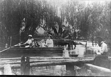 Kiewa Valley Historical Society
Photo - Water Wheel and Punt on the Kiewa River - Tangambalanga Homestead
In early times, Homesteads were part of pastoral runs many of which had frontage onto a river.Tangambalanga Homestead, on the Kiewa River, was subdivided in 1862 from T. Mitchell to Thomas BrownBlack and white shiny photo with women and children in a boat on 'flood' waters and a woman on the bank near a footbridge or jetty. The ladies are wearing hats, long skirts and blouses. In the background there is a large water wheel and trees. This photo is published on Page 19 of 'A History of the Kiewa Valley' by Esther Temple and David Lloyd.tangambalanga homestead, water wheel on the kiewa river, punt on the kiewa river -
 Greensborough Historical Society
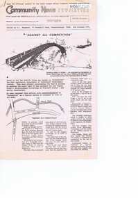
Newsletter, Greenhills and North Greensborough Progress Association, Community News: official journal of the Greenhills and Nth. Greensborough Progress Association and the Apollo Parkways Progress Association. 6th October, 1975, 06/10/1975
This edition includes a report on the Progress Association's [September 1975] meeting, Against all competition [Plenty River's footbridge at Flintoff Street], From the Council Chambers, Apollo Uprising! Family Day Care scheme. A digital copy of this Newsletter is available from Greensborough Historical Society.Newsletter, 6 p., illus.greenhills and north greensborough progress association, greenhills, apollo parkways progress association, apollo parkways -
 Darebin Parklands Association
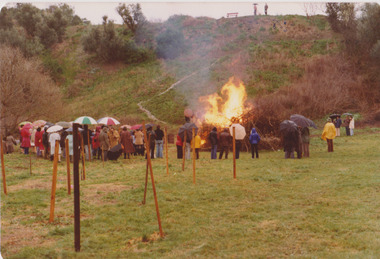
Opening of the bridge August 1979, Rockbeare Park Conservation Group, 1979
Colour photograph. Opening of bridge showing bonfire ; showing hill behind footbridge with dead blackberry canes on right. This item and all other Darebin Parklands Association archival material is now held by State Library Victoria (Accession No: YMS 13746). Please contact State Library Victoria if access is required.Annotated on back. -
 Sunshine and District Historical Society Incorporated
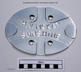
Base Plate, New H.V.McKAY FOOTBRIDGE, Circa 2013-2014
The steel mesh and crossbar sides of the new H.V.McKay footbridge are designed to replicate the appearance of the old crossbar gates which were at the old H.V.McKay works. The new bridge contains 111 of these plates attached to the centre of all crossbar sections which enclose both sides of the walkway of the bridge. The plate is a donated spare which was left over from the original manufactured plates that were attached to the new H.V.McKay footbridge. The plate is in our possession for safe keeping and for future reference.Stainless steel oval shaped plate with four holes for mounting to mesh sides of the walkway on the bridge. The plate has engraved lettering and lines intended to replicate a Sunshine Crossbar gate. H.V.McKAY SUNSHINE (The small c is underlined which can't be replicated on this data base)base plate, stainless steel plate, crossbar gates, regional rail link, hv mckay footbridge, h.v.mckay footbridge, sunshine -
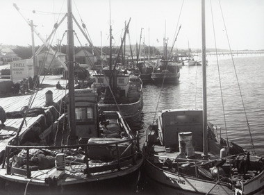 Lakes Entrance Historical Society
Photograph - Fishing Boats, 1955c
Black and white photograph of the eastern wharf, showing many fishing vessels moored at jetty, variously known as Harbecks Wharf and Scallop Wharf. Two sheds and fuel shed, motorbike, fishing nets and people on the jetty. Tops of War Memorial cypress trees, Cunninghame Arm Footbridge in background. Lakes Entrance Victoria fishing industry, waterfront, boats and boating, memorials -
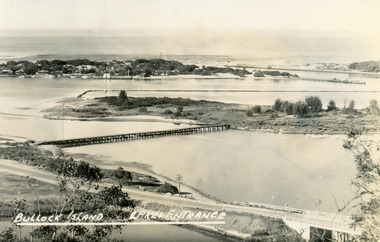 Lakes Entrance Historical Society
Postcard - Bullock Island, Bulmer H D, 1945
Black and white postcard of Bullock Island, Lakes Entrance, showing an extensive rock groyne to the south of the island, into which dredged sand and spoil is to be placed in order to extend the island's area. North Arm bridge, Bullock Island footbridge, New Works settlement and Entrance channel also in image. Lakes Entrance VictoriaBullock Island, Lakes Entranceboats and boating, fishing industry, islands -
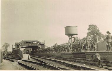 Bendigo Historical Society Inc.
Postcard - ACC LOCK COLLECTION: B&W PHOTO OF A RAILWAY STATION CROWDED WITH SOLDIERS, POSTCARD, 1914-1918
Postcard, WW1, B&W photo of the Warminster railway station in Wiltshire. Dozens of Australian soldiers standing on the RHS platform awaiting the train to take them on leave. Footbridge between the two platforms. Water tank in the background. Two copies. Handwritten in ink on the back of one 'Aussies' awaiting the Leave Train Warminster Wilts March '18postcard, postcard, ww1, australian soldiers, warminster, wiltshire, railway station -
 Ringwood and District Historical Society
Photograph, Mullum Creek. Taken from footbridge at end of Adelaide St, Ringwood. Aug. 1973
See also 2983Backing sheet on two copies reads, "Mullum Creek, Aug. 1963. Taken from footbridge at end of Adelaide St." Other copy reads, "Same area of flooded Mullum Creek as photo 403. A week later 1963".(Photo 403 is RE34 in Record 2983) -
 Ballarat Tramway Museum
Photograph - View from Ballarat Railway Station footbridge, Ken Magor, c1950
The photo shows an SEC tram crossing the railway level crossing in Lydiard St North from the Ballarat Railway station footbridge. Shows shelters and closed gates at the end of the platforms used to control passenger access. Victoria House in the background. Not dated, probably during the early 1950s. See also item 8897 for a similar photograph.Yields information Ballarat Railway Station and the level crossing.Black and white print with notes on rear."Ken Magor Neg No. 1902" and two pencil numbers "91" and "19"trams, tramways, lydiard st north, level crossing, railway station, ballarat railway station -
 Lakes Entrance Historical Society
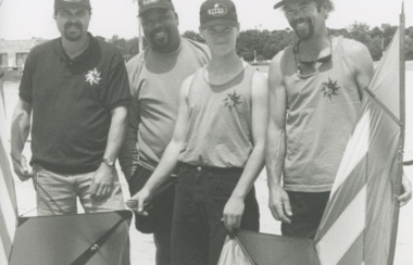
Photograph - Kite Festival Dustan Tackett Al Washington Rick Tackett and Stephen Bates. Drum Band, 1/11/1995 12:00:00 AM
Kite Team Invisible Wind from Portland Oregon USA which competed in the International Kite Festival Dustan Tackett Al Washington Rick Tackett and Stephen Bates Lakes Entrance Victoria. Drum band performing at the International Kite Festival venue near the Footbridge Lakes Entrance number 04049.1 size 9x 11.5 cmBlack and white photograph of Kite Team Invisible Wind from Portland Oregon USA which competed in the International Kite Festival Dustan Tackett Al Washington Rick Tackett and Stephen Bates Lakes Entrance Victoria. Also 2 other photos , Drum band and people under large inflatable ball festival, sports, kites, events, beaches -
 Kew Historical Society Inc
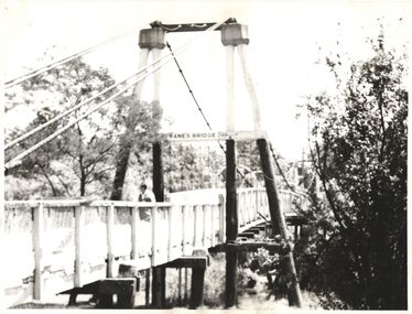
Photograph - Photograph (copy), Kanes Bridge, Studley Park, 195-1955
In 1928 a footbridge was erected to link Kew with the public golf course across the Yarra. The total cost of construction came to 250 pounds and the bridge became known as Kane's Bridge. During the 1934 floods the bridge was washed downstream, and was subsequently rebuilt. The present form of the bridge resembles the earlier bridge which crossed from the Yarra Bend Asylum to Kew, further upstream. (VHD)This work forms part of the collection assembled by the historian Dorothy Rogers, that was donated to the Kew Historical Society by her son John Rogers in 2015. The manuscripts, photographs, maps, and documents were sourced by her from both family and local collections or produced as references for her print publications. Many were directly used by Rogers in writing ‘Lovely Old Homes of Kew’ (1961) and 'A History of Kew' (1973), or the numerous articles on local history that she produced for suburban newspapers. Most of the photographs in the collection include detailed annotations in her hand. The Rogers Collection provides a comprehensive insight into the working habits of a historian in the 1960s and 1970s. Together it forms the largest privately-donated collection within the archives of the Kew Historical Society.A photographic copy of an older photograph of Kanes Bridge."Kanes Bridge"kanes bridge, yarra river, bridges - kew (vic.) -
 Kew Historical Society Inc
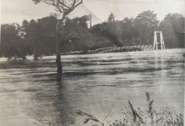
Photograph - Kane's Bridge on the Yarra River, December 1934
In 1928 a footbridge was erected to link Kew with the public golf course across the Yarra. The total cost of construction came to 250 pounds and the bridge became known as Kane's Bridge. During the 1934 floods the bridge was washed downstream, and was subsequently rebuilt. The present form of the bridge resembles the earlier bridge which crossed from the Yarra Bend Asylum to Kew, further upstream. (VHD)Original, black and white positive of Kane's Bridge in December 1934, when the 'great flood' of the Yarra caused the bridge's destruction. Inscribed verso: "Kane's Bridge Yarra in flood Dec 1934"river yarra, yarra -- kew (vic.), kanes bridge, 1934 floods -
 Kew Historical Society Inc
Photograph - Kane's Bridge destroyed by the 1934 Flood, 1934
In 1928 a footbridge was erected to link Kew with the public golf course across the Yarra. The total cost of construction came to 250 pounds and the bridge became known as Kane's Bridge. During the 1934 floods the bridge was washed downstream, and was subsequently rebuilt. The present form of the bridge resembles the earlier bridge which crossed from the Yarra Bend Asylum to Kew, further upstream. (VHD)Black and white positive print (identical to 2021.70 but with a different annotation) showing the destruction of Kane's Bridge in the floods of 1934. The Kodak paper would indicate a 1950s reprinting.Annotation verso: "Kane's Bridge in 1934 flood / Dec. 1934.kane's bridge, river yarra, yarra valley, 1934 floods -
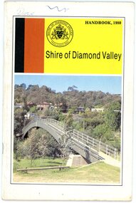 Greensborough Historical Society
Book, Shire of Diamond Valley, Shire of Diamond Valley Handbook 1980, 1980_
Guide to services provided by Shire of Diamond Valley. The Shire of Diamond Valley was a Local Government Area located about 20 kilometres northeast of Melbourne. The shire covered an area of 74.38 square kilometres and existed from 1964 until 1994. Cover illustration of footbridge over the Plenty River at Flintoff Street. The span is 50 metres and cost $56,100 to build in 1978.Annual guide to services in Shire of Diamond Valley32 pages, col illus., maps. shire of diamond valley, greensborough, handbooks -
 Bendigo Historical Society Inc.
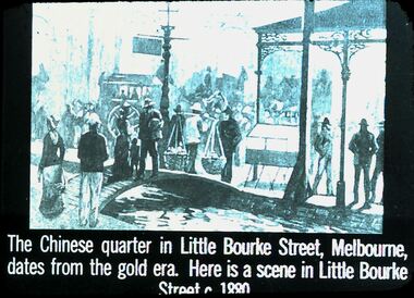
Slide - DIGGERS & MINING. THE CHINESE ON THE GOLD FIELDS, c1880
Diggers & Mining. The Chinese on the Gold Fields. Slide: The Chinese quarter in Little Bourke Street, Melbourne, dates from the gold era. Here is a scene in Little Bourke Street c1880. Shows a footbridge over creek many shoppers male and female including Chinese out shopping. Includes buildings and a large carriage in background. Markings: 11. Used as a teaching aid.hanimounteducation, tertiary, goldfields -
 Eltham District Historical Society Inc
Negative - Photograph, J.A. McDonald, Eltham-Yarra Glen Road, Lower Plenty footbridge, Sep. 1955
The Eltham-Yarra Glen Road as designated originated at the Shire of Eltham boundary at the Plenty River. West of the river the road was known as the Heidelberg-Eltham Road. The section from the Plenty River is now known as Lower Plenty Road which becomes Main Road. The footbridge no longer exists but was originally sited to the south, adjacent to the old Lower Plenty Bridge, now part of the Plenty River Trail. Record of various Shire of Eltham infrastructure works undertaken during the period of 1952-1962 involving bridge and road reconstruction projects, sometimes with Eltham Shire Council Project Reference numbers quoted. It was during this period that a number of significant improvements were made to roads and new bridges constructed within the shire that remain in place as of present day (2022). In many situations, the photos provide a tangible visible record of infrastructure that existed throughout the early days of the Shire. The album was put together by or under the direction of the Shire Engineer, J.A. McDonald.1955-09, eltham-yarra glen road, lower plenty footbridge, lower plenty, lower plenty bridge, lower plenty road, main road, plenty river trail, bridge construction, infrastructure, shire of eltham -
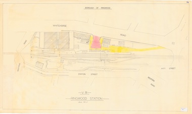 Ringwood and District Historical Society
Plan, Borough of Ringwood - VR Ringwood Station - Circa 1930s
Technical drawing of Ringwood Railway Station features, surrounding streets and buildings including Cool Stores, Packing Shed, Coke Bin, Coal Box, Dam, Garage, Shops, ES&A Bank, Station Master's Residence, Drill Hall, Goods Shed, Signal Box, Passenger Platform, Footbridge, and Clock Tower at Warrandyte Road. Station entrance and traffic access areas shaded red and yellow.Scale: 1"=40' -
 Lakes Entrance Historical Society
Photograph - Kite Festival, 1/11/1995 12:00:00 AM
Princes Highway viewing Point Kalimna showing Bullock Island during the International Kite Festival. The vast expanse of dumped sand perfect for Kite Flying but not the environment covers a large area of the island Lakes Entrance Victoria. Also a colour photograph taken of banners and kites at the Foorbridge venue of the International Kite Festival number 04048.1Colour photograph taken from Princes Highway viewing Point Kalimna showing Bullock Island during the International Kite Festival. The vast expanse of dumped sand perfect for Kite Flying but not the environment covers a large area of the island Lakes Entrance Victoria. Also 2 colour photographs taken of banners and kites at the Footbridge venue of the International Kite Festival number 04048.1 and 04048.2 sports, kites, events -
 Eltham District Historical Society Inc
Negative - Photograph, J.A. McDonald, Eltham-Yarra Glen Road, Lower Plenty footbridge, Sep. 1955
Tony Carberry and J. Jolly The Eltham-Yarra Glen Road as designated originated at the Shire of Eltham boundary at the Plenty River. West of the river the road was known as the Heidelberg-Eltham Road. The section from the Plenty River is now known as Lower Plenty Road which becomes Main Road. The footbridge no longer exists but was originally sited to the south, adjacent to the old Lower Plenty Bridge, now part of the Plenty River Trail. Record of various Shire of Eltham infrastructure works undertaken during the period of 1952-1962 involving bridge and road reconstruction projects, sometimes with Eltham Shire Council Project Reference numbers quoted. It was during this period that a number of significant improvements were made to roads and new bridges constructed within the shire that remain in place as of present day (2022). In many situations, the photos provide a tangible visible record of infrastructure that existed throughout the early days of the Shire. The album was put together by or under the direction of the Shire Engineer, J.A. McDonald.1955-09, eltham-yarra glen road, lower plenty footbridge, j. jolly, lower plenty, lower plenty bridge, lower plenty road, main road, plenty river trail, tony carberry, bridge construction, infrastructure, shire of eltham -
 Eltham District Historical Society Inc
Photograph, Odyssey House Victoria, 28 Bonds Road, Lower Plenty, 6 March 1990
Odyssey House drug rehabilitation centre in Bonds Road, Lower Plenty is a distinctive landmark, especially when viewed from across the Yarra at Templestowe. It was built in the 1950’s as a seminary for the Blessed Sacrament Fathers. Because of the poor and circuitous road access, a suspension footbridge was built across the river. As well as providing easy access for the priests residents of Templestowe could attend services at the seminary. The bridge is now part of the Yarra Trails system.Colour photographlower plenty, bonds road, odyssey house -
 Melbourne Tram Museum
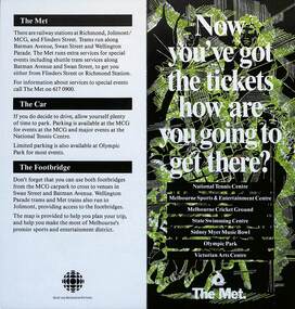
Pamphlet, The Met, "Now you've got the tickets how are you going to get there?", mid 1990s
Pamphlet "Now you've got the tickets how are you going to get there?" published jointly by The Met and Sport and Recreation Victoria with a map of the major sporting venues in the city area and the Victorian Arts Centre. Published before the diversion of the Batman Ave tram line via Flinders St. Gives tips on parking, train/tram travel, and the MCG footbridge. The line was diverted via Flinders St on 6/6/1999 - see reference. yields information about the travelling to the major Melbourne sports venues.Pamphlet - 2 fold DL printed in colour with map.trams, tramways, the met, sporting venues, public transport, maps, batman ave, batman avenue -
 Bendigo Historical Society Inc.
Photograph - HARRY BIGGS COLLECTION: HIGH ST. BENDIGO, 1857
Harry Biggs Collection. Black & white photo of High St. Bendigo. Shop signs visible - T. Baldwin Hair Cutting, shaving shampooing; Burston's Colonial Boot Store, Royal Hotel, Britannia House. A sign post: 'Eadie & McIntyre Gold Office'. In foreground Bendigo Creek with a footbridge to the left. Two gnarled trees in centre of photo. Photo taken near View Point. Image taken in 1850's.place, building, commercial, harry biggs collection, high st. bendigo -
 Lakes Entrance Historical Society
Postcard - Aerial view of Lakes Entrance, 1940c
Also 1 Black and White Photographic copy 12.5cmx17.5cm, fair condition P01154-2Black and White Photographic miniature postcard showing the southern abutment of the North Arm Bridge, town, including Club Hotel and garage, sand, hummocks and in distance, the footbridge across Cunninghame Arm. Workmens huts at bridge approach, motor car and truck parked westside of bridge approach. Boats in western boat harbour. Atlantic Ethyl sign behind Club Hotel, and tanks on tall tankstands. Lakes Entrance Victoriabridges, coast, hotels, boats and boating, fences, transport -
 Kew Historical Society Inc
Print - Walmer Street Foot Bridge, 1901
Photographic print of the Walmer Street Bridge. The view of the Bridge is from the Abbotsford side of the Yarra. A section of pipe on the near side of the bridge is a remnant of the irrigation pipes that carried water from above Dight's falls to the Melbourne Botanic Gardens. The former bridge, constructed in 1896 was swept away in the 1901 Flood. It has two major brick piers while the remainder of the trestle supports are metal. The original photograph from which this copy was made was taken after 1901 as it shows the second bridge under construction. Houses in Young Street, Kew, can be seen on the far side of the river.Reverse: " Walmer St footbridge 1901 being repaired after flood / Constructed 1892 substantially renewed in 1901 and in 1928 / Rebuilt in 1977 by Kew Council aided by State funding. Won for designer Martin Aylard a New Zealand award presented by the timber Research & Development Assoc / Site of Simpsons Road passenger foot ferry". bridges - yarra river -- kew (vic.), walmer street bridge -- kew (vic.)